A83 Rest and Be Thankful
Overview
The A83 Rest and Be Thankful project is looking at developing a resilient and sustainable route to Argyll and Bute, and a long-term solution to the challenges at the Rest and Be Thankful, which has been the site of a number of landslides.
We'll be updating our project storymap to share information about the work being undertaken as part of the project development and there'll also be further opportunities to share your feedback as design work continues.
A83 Rest and Be Thankful updates
Public engagement events on the long-term solution at the A83 Rest and Be Thankful are being held from 18 to 21 March at four venues across Argyll and Bute.
The events will provide local communities and road users with the opportunity to meet the designers, as well as view and comment on the design development and the progress towards delivering the medium-term improvements along the Old Military Road (OMR).
Cabinet Secretary for Transport Fiona Hyslop said:
“The Scottish Government is steadfast in its commitment to delivering a long-term solution to the landslip risks at the A83 Rest and Be Thankful.
“The announcement last June of the preferred route option for the long-term solution was a significant confirmation of our commitment to improve the route. The design work for this is being progressed at pace with a view to publishing draft Orders by the end of this year.
“At the same time, we are progressing our plans to increase the resilience of the temporary diversion route along the Old Military Road (OMR) until the long-term solution to the challenges at the Rest and Be Thankful is in place. The first phase of the work to realign the southern end of the OMR route, reducing the risk of flooding, is well underway and expected to be complete this spring.
“Design work for both the long-term solution and future phases of the medium-term improvements is being taken forward and these public engagement events next month will update local communities and road users on how this design work is progressing and let them comment on our latest plans. A virtual exhibition will also go live on 18 March for those unable to attend the public events.
"All of this underlines the Scottish Government’s commitment to work with key stakeholders and local communities to ensure that Argyll and Bute remains open for business.”
First phase of ground investigations for the Old Military Road improvements now completed at the A83 Rest and Be Thankful
Work took place from Monday 24 July and took one week to complete. The information gathered from this ground investigation will provide a detailed geotechnical understanding of the ground conditions, this being essential to inform the detailed design and construction of the first phase of the Old Military Road improvements. The associated news article for can be found here: First phase of ground investigations for the Old Military Road improvements to get underway at the A83 Rest and Be Thankful | Transport Scotland
Preferred Route: Permanent, long-term solution
The preferred route for the Access to Argyll and Bute (A83) project was announced as the Brown Option in Spring 2023.
The preferred route is generally located along the existing A83, starting at the Croe Water and ending north of the junction with the B828.
To protect users from debris flows and landslides, a structure known as a debris flow shelter will be provided to cover the part of the road considered at risk from the Beinn Luibhean slope. The debris flow shelter will put a roof over the road, supported by a robust protection wall on the hill ward side and a series of columns on the valley side to maintain an open aspect to the glen. Behind the protection wall there will be a catch pit, designed to channel land slip material and rock fall, allowing it to be removed safely and efficiently without adversely impacting the road user or the slopes below the A83.
Work continues to be taken forward at pace to further develop our proposals, including the detailed development and assessment of the preferred route option (i.e. Design Manual for Roads and Bridges (DMRB) Stage 3 assessment) along with the preparation of an Environmental Impact Assessment and draft Orders.
Public exhibitions for the preferred route were held from 12th to 15th June 2023 which provided local communities and road users the opportunity to see and comment on the preferred route.
Details of the exhibitions
The Three Villages Hall, Arrochar, G83 7AB
- Monday 12th June – 12 to 7pm
- Tuesday 13th June – 10am to 5pm
Lochgilphead Baptist Church, Lochgilphead, PA31 8LP
- Wednesday 14th June – 12 to 7pm
- Thursday 15th June – 10am to 5pm
If you were not able to attend the public exhibitions, a virtual exhibition was available online.
Materials presented at the exhibition are available here - A83 Access to Argyll and Bute.
Improvements to the Old Military Road
On 23 December 2022 the then Minister for Transport, Jenny Gilruith MSP announced improvements to the Old Military Road as a medium term solution to improve the resilience of the temporary diversion route to the A83, should it be closed. A link to a report which sets out the option development and assessment process for a medium-term solution is provided below:
Plans and further information can be found on the A83 Storymap website.
Recommended preferred route corridor
From an initial public consultation on 11 route corridor options that was held in Autumn 2020 and the multi-disciplinary work that has subsequently taken place to assess these route corridor options, a recommended preferred route corridor was announced in March 2021. This is Route Corridor 1 through Glen Croe.
Details of five possible route options through the preferred route corridor were published at the same time. These have been developed from further assessment undertaken by the project team. These route options were each designated a colour:
- brown
- yellow
- green
- purple
- pink
The brown option closely follows the alignment of the current A83 Trunk Road, while the yellow, green, purple and pink options were alternative routes through Glen Croe. These route options included the construction of new lengths of carriageway, viaducts, tunnels and debris flow shelters as well as considering further landslide mitigation works.
From March until the end of May 2021, we invited initial views on the recommended preferred corridor and the possible route options within the corridor. Further details can be found below:
A83 Storymap and Initial Consultation Reports
Public engagement is extremely important to us – it’s a vital part of our work as we develop our plans.
Public exhibitions were held in June 2023, in-person and online, to present the preferred route option that has been selected. The exhibitions provided local communities and road users the opportunity to find out more about the preferred route, speak with project team members and provide feedback. Further details can be found in Section 6.
To help us keep you informed of the project’s progress, and to give you an insight into the work that goes into a complex engineering and major infrastructure project such as this, we have a dedicated storymap to share more information with you. We hope you enjoy reading this and look forward to your continuing interest in this project.
We have also published the findings from our initial consultation on the 11 route corridor options that was held between 23 September and 30 October 2020 as well as our findings on the preferred route corridor consultation which was held between 14 March and 28 May 2021.
We would like to thank everyone who responded to these consultations.
- Consultation Report: Public Consultation on Route Corridor Options
- Consultation Report: Public Consultation on the Preferred Route Corridor
Design Manual for Roads and Bridges (DMRB) Assessment Reports
Following the announcement of the preferred route in Spring 2023, the DMRB Stage 2 Assessment Report was published following detailed assessment of the five route options and identification of the preferred route.
The DMRB Stage 3 assessment and development of the preferred route design is now underway.
At the end of April 2021, we published the (DMRB) Stage 1 Assessment Report. This follows on from the Preliminary Assessment and describes further assessment of the preferred route corridor and initial proposed options now being further developed.
Preliminary Assessment Work
We have carried out preliminary assessment work to develop a robust understanding of the existing conditions within each of the 11 route corridor options previously identified and the implementability considerations, or how feasible, affordable and publicly acceptable they would be to develop. This included a high-level environmental assessment. This was the first step in the work that was required to identify a preferred route corridor option.
We also assessed four additional route corridors, which are located in proximity to Glen Croe, that were identified in feedback received from the public during the consultation held in September and October 2020. However, the assessment of these additional route corridors confirmed that they are less advantageous than the recommended preferred route corridor through Glen Croe.
The output of this early assessment work is documented in the Preliminary Assessment Report. This report includes details on each of the route corridors, including the four additional route corridors received during our public consultation, and how they have been assessed.
Strategic Environmental Assessment
Following publication of the SEA Scoping Report, which provides information on the environmental topics that are to be included in the SEA, as well as the baseline data, relevant plans, policies and proposed methodology that will be used. We published the SEA Environmental Report in April 2021. In consultation with a range of stakeholders, we have identified environmental constraints along each proposed route corridor.
Environmental constraints include sensitive landscapes, sites of ecological note, cultural heritage resources and other environmental features and we will consider how these may be affected by the proposed scheme. We published the SEA Post Adoption Statement, which reports how environmental considerations have been integrated into the project and how consultation feedback was taken into account, in November 2021.
Background
The section of the A83 between Ardgartan and the Rest and Be Thankful car park has a history of hillside instability, in particular on the slopes above the Rest and Be Thankful.
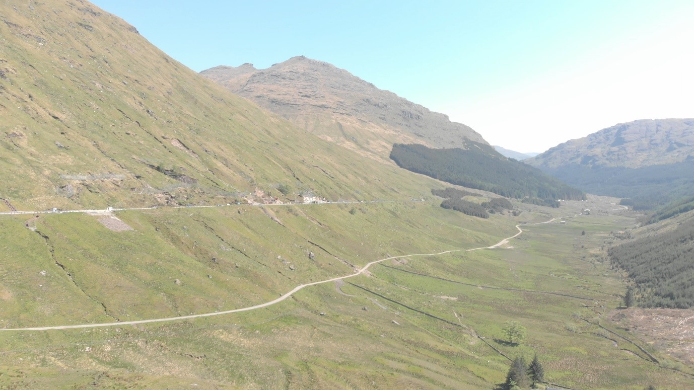
The Rest and Be Thankful is the highest point on the A83, separating Glen Kinglas from Glen Croe. It is also one of the places in Scotland with the highest risk of landslides and debris flow hazards. These have increased in recent years due to the frequency of heavy, intense and prolonged periods of rainfall.
Following a number of landslides in 2004, Transport Scotland carried out the Scottish Road Network Landslides Study. As part of this study a hazard assessment and ranking exercise was carried out for debris flow. From this assessment the A83 Ardgartan to Rest and Be Thankful is one of the most highly ranked debris flow hazard sites in Scotland.
As part of the £87 million invested in the maintenance of the full length of the A83 since 2007, over £16 million has been invested in landslide mitigation works at the Rest and Be Thankful. This was to help keep Argyll open for business by reducing the impact of landslides on the A83.
We are aware of the A83's importance as the primary route to Argyll. In 2012, the A83 Route Study was carried out to identify and assess potential options to minimise the effects of road closures.
Our objectives then were to:
- reduce the impact on journey times by reducing the frequency and duration of road closures caused by landslides
- reduce the economic impact to the A83 study area by reducing the frequency and duration of road closures.
The resulting landslide measures have seen the opening of the alternative military road, installation of catchfences, catchpits and improvements to drainage at this location. These interventions have already proven to be successful, with the Standard Incident Diversion Route not being in use since 2021.
We continue to explore ways to reduce the risk of impacts caused from landslides in the area.
Construction of the latest roadside catchpit at the Rest and Be Thankful, a project valued at £3.4 million, is currently scheduled to be completed in summer 2023. Once complete, the Phase 3B catchpit will provide an additional 1,800 tonnes of volume to collect debris flow from landslides, to add to the 19,400 tonnes provided in the existing five catchpits.
We have also progressed the programme to proactively plant trees on the hillside to help reduce the risk of landslides in the area. Land purchase at the Rest and Be Thankful has completed and we are working closely with Forestry & Land Scotland to reintroduce the required local provenance native vegetation on the hillside.
Short, Medium and Long term schemes
Short-term mitigation
In terms of the ongoing short term work since 2007, over £16 million has been invested in landslide mitigation works at the Rest and Be Thankful, to help keep Argyll open for business by reducing the impact of landslides on the road. This, along with the use of the Old Military Road, has meant that the longer diversion route has not had to be used due to a landslide since February 2021.
Since August 2020, Engineers have installed additional landslide mitigation measures to enable the use of the A83 including debris fences, a roadside pit and material barriers. Hillside drainage paths have also been diverted to help stabilise the material with the landslide scar area.
Short term mitigation work continues to be taken forward at the Rest and Be Thankful. An assessment of the hillside following the August 2020 event highlighted that an additional catch pit would add further resilience to the A83. The construction of this catch pit is ongoing and is expected to be completed in summer 2023.
To coincide with the planned completion of the catch pit, resurfacing works are programmed on the A83 between the River Croe (Cobbler) bridge and the Lochgoilhead junction over a length of 1.8km from 11 June to 16 July. The works will be carried out under traffic management during day time hours with night time closure of the A83 between 11 and 22 June diverting traffic on to the OMR (7pm to 7am). By accelerating future programmed resurfacing schemes in this area, the proposed works will allow the A83 to return to full capacity for an extended period of time to minimise future disruption. The resurfacing works also enable drainage improvement works to add further resilience to the A83 at the Rest and Be Thankful. This information was communicated to stakeholders on 05 June 2023.
We are also progressing a programme to proactively plant trees on the hillside to help reduce the risk of landslides in the area. Land purchase at the Rest and Be Thankful has been concluded and Transport Scotland is working with Forestry & Land Scotland to reintroduce the required local provenance native vegetation on the hillside.
Communications with stakeholders has been maintained with the main focus on operational updates, but also by making it clear that Argyll remains open for business. Specific focus was also given to keeping Taskforce members updated, who have been asked to share this locally.
Land purchase of the upper hillside at the Rest and Be Thankful has been concluded and Transport Scotland is working closely with Forestry and Land Scotland on a tree planting scheme, to help stabilise the hillside. Deer fencing was installed in 2021 and a planting trial was successfully completed in December 2021. The hillside planting commenced in March 2022 and is ongoing into 2023.
The short-term work involves the ongoing mitigation works being undertaken by BEAR Scotland on behalf of Transport Scotland to improve the resilience of the existing A83 and Old Military Road. This work includes the installation of a debris cage and new culvert, construction of an additional catchpit, debris fencing and flood mitigation measures at the River Croe crossing.
- Read the latest updates from BEAR Scotland on the short-term A83 works
Medium-term solution
In December 2022 the preferred route for a medium term solution was announced. Improvements to the existing Old Military Road through the Glen Croe corridor are being made to make it a more resilient diversion route until the long term solution to the problems at the Rest and Be Thankful is in place. These improvements will improve the resilience of the diversion route, reduce journey times, and are the quickest to implement, of relatively lower cost and would have the least impacts overall across the range of criteria assessed of the medium term options under consideration.
A detailed programme for the proposed improvements is now being developed. These include debris catch fences, temporary bunds, drainage improvements and widening and discrete realignment to improve bends and avoid flooding. It is expected that these works will be carried out on a phased basis starting later this year.
Long-term solution
Finally, the announcement of the preferred route option for a permanent, long-term solution to the challenges at the Rest and Be Thankful on 2 June 2023 is a very important milestone in finding a solution to this long-standing problem. The proposed new debris flow shelter will help protect the road and road users from future landslides. Work will now be taken forward at pace to further develop our proposals.
- Read the latest updates on the medium and long term schemes
This work underlines the Scottish Government’s commitment to continued work with key stakeholders to ensure that Argyll & Bute remains open for business.
This web page explains the process that we will follow and how stakeholders and the public will have the opportunity to be involved.
The challenges
Transport Scotland will work with key agencies, local authorities and local communities to address the challenges, which include:
- working in challenging landscapes
- construction of new major structures
- managing the impact on the many environmental designations in the area and safeguarding the outstanding landscape
- improving access to tourist and recreational sites
- minimising impact of construction on road users and local communities.
Stages of necessary development work
As work on the programme progresses, Transport Scotland will ensure that arrangements for participation by stakeholders and members of the public are inclusive, open and transparent. We will encourage a wide range of participants to get involved and provide their comments and feedback.
All proposals are developed following the Design Manual for Roads and Bridges (DMRB) as used on all major infrastructure projects.
Planning permissions will be obtained through the Roads (Scotland) Act 1984.
Stage 1 (Strategic Assessment)
We completed Stage 1 of the project in April 2021.
- Strategic planning and appraisal of transport interventions for Argyll is being progressed through the second Strategic Transport Projects Review (STPR2) which follows the publication of the National Transport Strategy in February 2020
- We will work in parallel with the STPR2 process, which will be the strategic business case for transport investment in Scotland for the next twenty years
- Eleven route corridors have been generated through the STPR2 process. This process included stakeholder engagement about problems and opportunities, both regionally and nationally, and included options workshops
- Read more information on STPR2, including key publications such as the Argyll & Bute STPR2 Initial Appraisal: Case for Change
- The Case for Change for Argyll & Bute evidenced the disruption impacts and resilience concerns relating to the trunk road network in Argyll, particularly the A83 at the Rest and Be Thankful
- Transport Scotland has appointed a project team from Jacobs Aecom to assist in the further development and appraisal of options for the A83 within Argyll. The team will carry out a strategic environmental assessment supported by associated preliminary engineering work
- The outcome is the identification of a preferred route corridor, as announced in March 2021. Opportunities for stakeholder and public comment and feedback will be provided throughout the design and development process as new information becomes available and/or local knowledge is required.
- Preliminary assessment work has been undertaken on these 11 route corridors and we invited local feedback on any key issues or constraints that would inform that process.
Stage 2 (Route Options Assessment)
We completed Stage 2 of the project and announced a preferred route option for a permanent, long-term solution on 2 June 2023.
- Development and assessment of route options within the preferred corridor
- This includes an engineering and environmental assessment of the potential impacts of each option which will inform the route choice
- During this stage, the options will be made available for consultation
- Following this assessment and consultation, the preferred option is then selected and taken forward to the detailed stage.
Stage 3 (Design and Assessment of Preferred Option)
- Detailed assessment and definition of the preferred option is currently underway.
- An Environmental Impact Assessment Report is being prepared, and the land required for the project is also being identified.
Statutory Process (Publication of Environmental Impact Assessment Report (EIAR) and Orders)
- The draft Compulsory Purchase Order (CPO), which defines the extent of the proposed land required to deliver the project, the draft Roads Orders, which define the line of the proposed infrastructure, and the EIAR are published
- Any statutory objections, which are lodged during the defined period but remain unresolved, are then considered at a Public Local Inquiry (PLI)
- If the objections are upheld following the PLI, the project may have to be amended and taken through the statutory process again
- If the objections are resolved or dismissed, then the draft Orders are finalised and made
- Following the publication of the Made Orders, there is a legal challenge period. After this point the legal permissions have been obtained and the preferred option can proceed with the necessary acquisition of land.
Procurement (Tender process to appoint a works contractor)
- Prior Information Notices (PIN) are issued and Contract Notices follow - inviting suppliers to express an interest in the procurement
- A pre-qualification process is used to shortlist suppliers that will be invited to tender
- An Invitation to Tender (ITT) is issued to the shortlist of suppliers. The tenders are evaluated by Transport Scotland, a supplier is selected, and the contract is awarded. The preferred option can then move to the construction phase.
Strategic Environmental Assessment
To assess the likely significant effects (both positive and negative) of this project on the environment, a Strategic Environmental Assessment (SEA) has been undertaken. An SEA assesses the impact of a public plan, programme or strategy on the environment.
The SEA team has worked closely with the engineering team throughout the project and this has helped develop viable mitigation and enhancement measures for the next project stages.
SEA Scoping Report
The first stage of the SEA was to produce a Scoping Report, to provide information on the environmental topics that were to be included in the SEA, as well as the baseline data, relevant plans, policies and proposed methodology that would be used. A copy of this report is available. The key environmental topics that were considered in the scoping baseline are as follows:
- Biodiversity, fauna and flora
- Population and human health
- Water
- Soil
- Air quality
- Climatic factors
- Material assets
- Cultural heritage
- Landscape and visual amenity
SEA Environmental Report
The Environmental Report stage is where the likely significant effects of this project are assessed. The assessment was undertaken for all the SEA topics identified at the scoping stage. Mitigation, enhancement and monitoring measures for all likely significant effects are documented in the report. A copy of the SEA report is provided below:
The SEA Post Adoption Statement reports how environmental considerations have been integrated into the project, and how consultation feedback has been taken into account.
Design Manual for Roads and Bridges (DMRB) Stage 1 Assessment Report
The Design Manual for Roads and Bridges (DMRB) Stage 1 Assessment Report follows on from the Preliminary Assessment and describes the more detailed assessment of the preferred route corridor. The report provides:
- A description of the existing conditions within the preferred route corridor, and for specific criteria the wider A83 Trunk Road
- A description of the five possible route options identified within the preferred route corridor
- An engineering assessment, of the five possible route options within the preferred route corridor
- A summary of findings of the Strategic Environmental Assessment (SEA)
- A traffic and economics assessment of the five possible route options within the preferred route corridor
- A description of risks present
Public engagement and consultation
Preferred route exhibitions - March 2024
Preferred route exhibitions for a permanent, long-term solution to the challenges at the Rest and Be Thankful
- Monday 18 March, 10am to 4pm - South Kintyre Development Trust Hall, 32 Kirk Street, Campbeltown, PA28 6BL
- Tuesday 19 March, 12noon to 7pm - Lochgilphead Baptist Church, Union Street, Lochgilphead, PA31 8LP
- Wednesday 20 March, 10am to 4pm - Lochgoilhead Village Hall, 8 Hall Road, Lochgoilhead, PA24 8AQ
- Thursday 21 March, 10am to 4pm - Three Villages Hall, Shore Road, Arrochar, G83 7AB
Visit the virtual exhibition or one of the in-person events.
For further information please visit the A83 Story Map: Access to Argyll and Bute (A83) Story Map (arcgis.com)
Exhibition materials
Preferred route option - June 2023
The preferred route for the permanent, long-term solution to the challenges at the Rest and Be Thankful for the Access to Argyll and Bute (A83) project was announced by the then Minister for Transport Kevin Stewart MSP.
We held public exhibitions from 12 to 15 June in Arrochar and Lochgilphead to present the preferred route option that has been selected.
The exhibitions provided local communities and road users the opportunity to find out more about the preferred route, speak with project team members and provide feedback.
Dates and times of the public exhibitions held are shown below:
The Three Villages Hall, Arrochar, G83 7AB
- Monday 12 June, 12 to 7pm
- Tuesday 13 June, 10am to 5pm
Lochgilphead Baptist Church, Lochgilphead, PA31 8LP
- Wednesday 14 June, 12 to 7pm
- Thursday 15 June, 10am to 5pm
A virtual exhibition room is also available for anyone unable to attend the in-person events.
We welcome your comments on the preferred route, please provide any comments you may have by 28 July via the feedback form, which can be found in the virtual exhibition room.
Materials presented at the exhibition are also available here - A83 Access to Argyll and Bute, Exhibition material.
For further information, please visit the A83 Story Map: Access to Argyll and Bute (A83) Story Map or email A83@WSP.com
We take public engagement very seriously and engage with a wide range of parties, including agencies, local communities, road users and the general public.
We'll be updating our project Story Map to share information about the work being undertaken as part of the project development and there'll also be further opportunities to share your feedback as design work continues.
If you have any questions in the meantime, you can find some additional information in our Frequently asked questions which will be updated regularly.
The table below shows how we'll consult with the public during the project.
| Stage | Work undertaken | Public consultation |
|---|---|---|
| Strategic Assessment | Baseline conditions Environmental constraints Broad range of potential options to be considered as part of more detailed design |
Public consultation to gain a better understanding of the local conditions |
| DMRB Stage 2 | Short list of five route options Outline of design details and environmental assessment |
Public consultation on the Preferred Option and any amendments to design details |
| DMRB Stage 3 draft Orders Publication | Preferred option and Environmental Impact Assessment Report Publication of draft orders |
Public consultation to provide progress updates. Representation to Environmental Impact Assessment Report and objection to draft Orders |
Key stages during the design and development process
Design Manual for Roads and Bridges Process - Access to Argyll and Bute (A83)
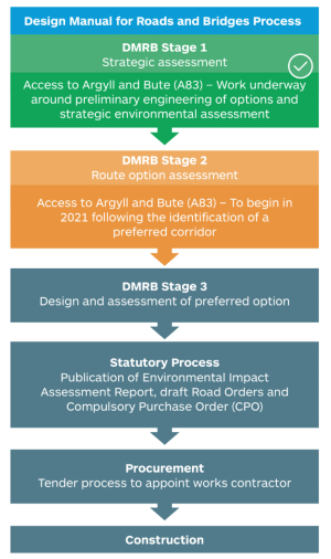
DMRB Stage 1 - Strategic assessment
The DMRB stage 1 assessment was completed in April 2021.
DMRB Stage 2 - Route option assessment
The DMRB Stage 2 assessment was completed in Spring 2023 with the announcement of the preferred route.
DMRB Stage 3 - Design and assessment of preferred option
The DMRB Stage 3 assessment is currently underway.
Statutory Process
- Publication of Environmental Impact Assessment Report, draft Road Orders and Compulsory Purchase Order (CPO)
Procurement
- Tender process to appoint works contractor
Construction
What happens next
Following the announcement of the preferred route option in Spring 2023, Transport Scotland, together with our technical advisors Atkins WSP Joint Venture, will further develop the preferred route option through the DMRB Stage 3 process and look for opportunities to deliver the permanent, long-term solution as quickly as possible.
- Read the latest information about what is happening with this project
Frequently asked questions
Answers to frequently asked questions on this project are shown below. If you can't find an answer to your question, you can contact our project team:
- by email at A83@wsp.com
- or by phone on 0131 316 8293, Monday to Friday between 9 am - 5pm.
Background
The A83 Trunk road is a major 98 mile/158 km road in the south of Argyll and Bute in the Scottish Highlands. The A83 is a vital artery route through Argyll, running from Tarbet on the western shore of Loch Lomond, where it splits from the A82, to Campbeltown at the southern tip of the Kintyre peninsular. The highest point along the route is known as the Rest and Be Thankful, separating Glen Kinglas and Glen Croe.
The section of the A83 between Ardgartan and the Rest and Be Thankful viewpoint car park has a history of hillside instability, in particular the slopes above the Rest and Be Thankful. Following several landslides in August 2020, one of which was the largest recorded in the area in the last 20 years, Jacobs Aecom were commissioned by Transport Scotland to undertake a Strategic Environmental Assessment (SEA) and provide preliminary engineering support services (PES) of route corridor options for access to Argyll and Bute including the A83 Trunk Road.
A preliminary assessment of all 11 route corridor options for improving access to Argyll and Bute and identifying a long-term solution to the ongoing problems at the Rest and Be Thankful has been completed and a Preliminary Assessment Report published.
Following this report and the over 650 responses to the public consultation on the scheme, the Cabinet Secretary for Transport, Infrastructure and Connectivity announced a preferred route corridor on 18 March 2021 – this is Route Corridor 1 through Glen Croe.
After the preferred route corridor was announced, feedback was received on five route options which included tunnels, viaducts and debris flow shelters. This feedback helped inform the assessment process and the preferred route was announced in Spring 2023.
We have undertaken substantial short-term investment in the existing A83 including installing a debris cage and new culvert, construction of an additional catchpit, debris fencing and flood mitigation measures at the Croe Water crossing.
Whilst detailed assessment of the preferred route is underway, Transport Scotland is progressing with the medium-term solution, which will see improvements made to the Old Military Road. The medium-term solution was announced in December 2022 and will deliver a safe and more resilient diversion route when the long-term solution is constructed. We are working at pace to ensure the medium-term improvements will start on site before the end of 2023.
Key Messages
The project’s key messages and the sub-messages that support them:
We are committed to developing long-term resilient and sustainable connectivity to Argyll and Bute
- Need to mitigate disruption to road users and the economic impact to the area from road closures along the A83 Trunk Road - a lifeline route to Argyll - particularly at the Rest and Be Thankful.
- Have launched project to deliver an alternative route to the existing A83 in parallel with the second Strategic Transport Projects Review (STPR2).
- STPR2 takes a national overview of the transport network with a focus on regions and will help delivery the vision, priorities and outcomes set out in the National Transport Strategy.
- In parallel with developing a long-term resilient solution both short-term and medium-term proposals are being developed.
We are committed to addressing the challenges at the Rest and Be Thankful section of the A83
- The slopes above the Rest and Be Thankful section of the A83 have a history of hillside instability.
- It is one of the places in Scotland with the highest risk of landslides and debris flow hazards.
- Recently it appears that severe weather (heavy and prolonged rainfall) and the associated landslips are becoming more frequent.
- A diversion route along the Old Military Road has been in operation since 2013, but has also been affected by landslides and closed as a result recently.
- If landslides close the A83 and Old Military Road, the standard diversion route along the A82, A85 and A819 is up to approximately 60 miles – we understand the disruption and frustration this causes.
Eleven route corridor options were considered to address issues at the Rest and Be Thankful and develop long-term resilient access to Argyll and Bute
- The route corridor options included a route corridor through Glen Croe where the existing A83 passes, but also other route corridors reflecting that there may be benefits from a different access to Argyll and Bute.
- We invited feedback on these options from stakeholders and the public via an online consultation launched on 23 September and running until 30 October 2020.
- Aim of the online consultation was to gather local information to inform the development of new access to Argyll and Bute as a long term sustainable and resilient alternative to the A83 Rest and Be Thankful.
- We also invited views on any other options they should be considering.
A preferred route corridor was announced 18 March 2021, and a consultation on the recommendation and possible route options
- The Cabinet Secretary for Transport, Infrastructure and Connectivity announced on 23 September 2020 that Transport Scotland would be taking forward the development and assessment work required to deliver an alternative infrastructure solution to the existing A83.
- He announced the preferred route corridor and his commitment to progressing substantial shorter-term and medium-term investment in the existing A83 and Old Military Road diversion in tandem with work to identify a permanent solution as part of a two-phased approach.
- The work involves a Strategic Environmental Assessment and preliminary engineering and traffic assessments, with the SEA containing the preferred route recommendation issued for consultation in Spring 2021.
- In recognition of the importance of pushing forward with this work, we have also started to consider five possible route options within the preferred route corridor.
The preferred route was announced in Spring 2023
Public exhibitions were held in June 2023 and the preferred route is available to view online.
We welcome your comments and feedback on the preferred route. Please provide any comments you may have as soon as possible and by 28 July 2023. Feedback can be provided via the virtual exhibition or by downloading the feedback form on the Transport Scotland website.
The project will engage with directly affected communities and businesses
- We launched a new project website on 23 September 2020 for the design work and where details of the 11 route corridor options could be viewed.
- Invited feedback from stakeholders and the public on these options and any others they wish to be considered.
- Input from stakeholders is vital to help gather the type of local background information required.
- As part of the ongoing public engagement, we have launched an interactive Storymap which will be developed and added to as the design moves forward and this will keep local communities and road users informed of progress on the project. The Story Map can be found here: Access to Agyll and Bute (A83) Story Map.
- A virtual exhibition room is available for all to view and provide feedback on the preferred route, which was announced in Spring 2023.
Questions & Answers
Q1 What are the current issues facing the A83 Trunk Road?
A1 The A83 is the primary route to Argyll. The highest point along the route is known as the Rest and Be Thankful, separating Glen Kinglas and Glen Croe.
The section of the A83 between Ardgartan and the Rest and Be Thankful viewpoint car park has a history of hillside instability, in particular the slopes above the Rest and Be Thankful. If landslides close the A83, the standard diversion route along the A82, A85 and A819 is up to approximately 60 miles. This causes disruption for road users and has an economic impact on the area.
Recently it appears that severe weather (heavy and prolonged rainfall) and the associated landslips are becoming more frequent.
There are other locations on the A83 where there have been landslides including Glen Kinglas and Cairndow, and other sections of the route also have a high landslide risk.
Other problems on the A83 include sections of narrow road width, sections of poor road alignment and provision for pedestrians. Sections of the A83 also have a high accident rate, with the proportion of serious accidents above the national average rate for Killed and Seriously Injured severity.
Q2 What are the current issues with the wider transport network?
A2 The lack of a good standard of transport infrastructure and public transport provision is considered to be constraining growth in the region.
Travel times to/ from, within and through Argyll and Bute under normal conditions (i.e. with no disruption due to accident or incidents) can be long and/ or unreliable.
The long journey times are a function of the region’s geography, the quality of its transport infrastructure and the reliability of public transport services. There is potential for conditions on the transport network (such as on roads and/ or ferries) to worsen given the increase in slower moving traffic generated by the anticipated growth in key sectors including marine sciences, forestry, tourism, aquaculture, and the wider food and drink sector.
Q3 What work has been undertaken so far?
A3 As part of the £82 million invested in the maintenance of the A83 since 2007, over £13.6 million has been invested in landslide mitigation works at the Rest and Be Thankful, to help keep Argyll open for business by reducing the impact of landslides on the A83.
Subsequent landslide measures have seen the opening of the alternative military road, installation of nets, catchpits and improvements to drainage at this location. Construction of an additional roadside catchpit at the Rest and Be Thankful began in September 2021 and was completed in June 2023. This £3.4 million scheme provides an additional 1,800 tonnes of volume to collect debris flow from landslides, to add to the 19,400 tonnes provided in the current five catchpits.
We are also progressing a programme to proactively plant trees on the hillside to help reduce the risk of landslides in the area. Land purchase at the Rest and Be Thankful has been concluded and Transport Scotland is working with Forestry & Land Scotland to reintroduce the required local provenance native vegetation on the hillside.
Q4 I’ve heard that it could be up to 10 years before we have a permanent resilient solution in operation – this is too long so what’s being done in the meantime?
A4 We can understand the frustration felt by the local community caused by disruption along the A83 and in particular at the Rest and Be Thankful.
As part of the £87 million invested in the maintenance of the A83 since 2007, over £16 million has been invested in landslide mitigation works at the Rest and Be Thankful, to help keep Argyll open for business by reducing the impact of landslides on the road.
Subsequent landslide measures have seen the opening of the alternative Old Military Road when the A83 is closed, installation of nets, catchpits and improvements to drainage at this location. Construction of an additional roadside catchpit at the Rest and Be Thankful began in 2021 and was completed in June 2023. This £3.4 million scheme provides an additional 1,800 tonnes of volume to collect debris flow from landslides, to add to the 19,00 tonnes provided in the current four catchpits.
On 3 December 2020 the then Cabinet Secretary Michael Matheson announced that construction was to start immediately on a new 175m landslide barrier adjacent to the local diversion to help bolster the resilience of this route. Work was completed in January 2021. More information can be found on the BEAR website.
We have also undertaken a programme to proactively plant trees on the hillside to help reduce the risk of landslides in the area. Transport Scotland is working with Forestry & Land Scotland to reintroduce the required local provenance native vegetation on the hillside.
Work is progressing to deliver a medium-term solution through Glen Croe to provide a safe and more resilient diversion route when the A83 is closed. In December 2022, the former Minister for Transport announced that the medium-term solution would consist of a programme of improvements to the Old Military Road. These improvements will reduce journey times by increasing the extent of two-way operation and improve the safety of the road by including landslide protection measures such as bunds and fences. These interventions will be in place prior to construction of the permanent, long-term solution to reduce the disruption to road users during the construction period. We are working at pace to ensure the medium-term improvements will start on site before the end of the year.
Q5 Why was the Brown Option chosen as the preferred route?
A5 Following the Stage 2 assessment, the Brown Option provides the following key benefits:
- Improved resilience and operational safety of the trunk road network by reducing the impact of disruption for travel to, from and between Argyll and Bute and the Central Belt of Scotland
- The greatest potential to be delivered quickly
- Most favourable performance across a broad range of environmental criteria, including; cultural heritage, visual, population and human health, climate, and materials and waste
- The greatest opportunity to encourage sustainable travel
Further information on why the Brown Option has been identified as the preferred route can be found in the DMRB Stage 2 report.
Q6 Why was Corridor 1 through Glen Croe chosen as the preferred route corridor?
A6 The preferred route corridor is more cost effective and quicker to deliver, having significantly less environmental constraints. In addition, while structural solutions such as shelters, tunnels or viaducts may be necessary in this corridor, these would be less technically challenging than the fixed links in other route corridor options. Assessment Summary Tables for each of the route corridors can be found in the Preliminary Assessment Report on our website.
Q7 How much will the project cost?
A7 The route option assessment has identified an estimated total scheme cost of between £405 million and £470 million for the preferred option. The cost estimate will be refined during the DMRB Stage 3 assessment process as the design is developed in more detail and detailed ground and survey information is gathered.
Q8 How will the project be funded?
A8 We will consider funding options and procurement routes as we progress the project through the next stage of development.
Q9 How were the options assessed?
A9 The work is being undertaken in accordance with the Design Manual for Roads and Bridges (DMRB) which is the UK-wide guidance used to develop and assess trunk road projects. The assessment work considers a range of environmental, engineering, traffic and economic factors and also considers the performance against the national and regional objectives.
Q10 What is the programme for the next stages of the assessment work?
A10 Following the preferred route announcement in Spring 2023, and conclusion of the DMRB Stage 2 assessment, we are now progressing with further assessment during DMRB Stage 3. This will include detailed ground investigation, ecological surveys and design development of sustainable travel facilities. The assessment will conclude with the publication of draft Orders and an Environmental Impact Assessment Report. We aim to complete this stage of assessment by the end of 2024. Transport Scotland will continue to take forward this work at pace and look to accelerate programme where possible.
Construction of the scheme can only commence once the statutory process is complete and a main works contractor is appointed.
Q11 What are the next steps for the project?
A11 Now that a preferred route option has been selected, detailed design and development will be progressed following the process set out in the Design Manual for Roads and Bridges – DMRB Stage 3 – assessment of the Preferred Scheme.
Q12 How can local people/ businesses/ community representatives be involved in the development of a preferred route option?
A12 We are committed to placing public engagement and meaningful dialogue with affected communities and other stakeholders at the heart of the development and delivery of plans for improving the route.
As work on the project progresses, we will ensure that arrangements for participation by stakeholders and the public are inclusive, open and transparent. We will also encourage a wide range of participants to get involved and provide their comments and feedback at key stages.
Public exhibitions were held in June 2023, and a virtual exhibition room is available for you to view and provide comments on the preferred route. The exhibition material and feedback form is also available to download from the Transport Scotland website.
Q13 How will environmental impacts be mitigated?
A13 A Strategic Environmental Assessment (SEA) has been completed to assess the route-wide constraints, issues and opportunities for the project. The SEA Environmental Report identifies the likely significant effects on the environment, including on issues such as biodiversity; population; human health; fauna; flora; soil; water; air; climatic factors; material assets; cultural heritage, including architectural and archaeological heritage; landscape; and the inter-relationship between these issues. Activities undertaken as part of the SEA include:
- Collation of constraints around along the A83 and consideration of significant environmental issues and risks
- Habitats Regulations Appraisal to consider effects on SAC, SPA and Ramsar sites
- Assessment of flood risks
- Engagement with statutory bodies and other interested stakeholders
- Development of strategic environmental principles and mitigation guidance for later design stages
As the scheme progresses through the DMRB process, environmental assessment will be ongoing and influential. The results of the Stage 2 environmental assessment informed the route option selection process, and identified any potential significant impacts in relation to topics such as noise, biodiversity landscape and visual, the water environment, cultural heritage and impacts on agricultural land, are being taken forward for more detailed consideration within the final stage of the assessment process, the DMRB Stage 3 assessment, which is now underway.
During Stage 3 scheme development, environmental assessment and engineering design will be undertaken in parallel to provide interaction between prevailing environmental standards and the objectives of the development and to allow effective consideration of environmental issues throughout the design process. Where possible and reasonably practicable, potential adverse environmental impacts of the scheme during both construction and operation would be prevented through this iterative approach to the design process, rather than relying on measures to mitigate potential impacts. Where complete prevention of potential impacts are not feasible, mitigation measures will be set out in the Environmental Impact Assessment Report to reduce potentially significant effects.
Q14 How is the Scottish Government addressing climate change in relation to roads?
A14 The Scottish Government is committed to tackling climate change. It is fully acknowledged that the transport sector is the biggest emitter of greenhouse gases and that reducing emissions from all parts of the transport system is essential for meeting our climate change ambitions. The National Transport Strategy (NTS), which sets the direction for transport over the next 20 years, makes clear that our transport system will help deliver our ambitious climate change agenda and net-zero 2045 emissions target. In addition, the update to the Climate Change Plan published in December 2020 shows a commitment to reduce car kilometres by 20% by 2030. To enable this, future transport investment decisions will be made in context of the Sustainable Travel Hierarchy which prioritises walking, cycling and public and shared transport options in preference to single occupancy private car.
The Scottish Government is also phasing out the need to purchase a petrol or diesel- powered car or van by 2030, a full five years ahead of the UK. A sustainable, low carbon transport network brings many additional benefits to communities and businesses. The Scottish Government is committed to maximising these co-benefits which means that individual transport projects should not be assessed in isolation but in combination with other projects and Scottish Government policies.
The Scottish Government needs to balance the extensive changes required to meet a target of net-zero greenhouse gas emissions with its duty to ensure that Scotland has a high quality and resilient transport system that meets the needs of all our population. As part of its current programme of infrastructure improvements the Scottish Government is committed to delivering sustainable and resilient strategic road connection into Argyll and Bute as an alternative to the current A83 at the Rest and be Thankful.
Q15 How is the environmental impact of a road scheme minimised?
A15 As part of the design and assessment of projects an Environmental Impact Assessment Report is published at the same time as the draft Road Orders are published.
The environmental impact assessment of each project gives consideration to potential impacts associated with the scheme including construction, consumption of material resources, and the production and management of waste during construction of the proposed scheme.
By applying key material and waste management principles, such as the waste management hierarchy, the impacts on natural resources and need for permanent disposal of wastes will be reduced. In particular, this will be achieved by re-using existing soils and infrastructure where possible, taking into consideration the environmental impacts of products during their procurement. Proposed mitigation measures developed as part of each scheme minimise materials use, maximise re-use and recycling of wastes and ensure all materials and waste are handled according to the regulatory requirements. These will be implemented through several plans addressing different aspects of construction site management, including a Site Waste Management Plan (SWMP) and a Construction Environmental Management Plan (CEMP).
Q16 How will provisions for cyclists be considered?
A16 In line with the Scottish Government’s vision to promote active travel in A Long-Term Vision for Active Travel 2030, the Cycling Action Plan for Scotland and the Trunk Road Cycling Initiative, suitable provision for all road users, including cyclists, is a large part of our major trunk roads projects.
Environmental mitigation and sustainable travel facilities, which will include bus and active travel, will also be incorporated into the preferred route design as part of the DMRB Stage 3 assessment where possible and appropriate.
Q17 What’s the status of improvements to the A82 between Tarbet and Inverarnan?
A17 The detailed development and assessment of the preferred option is well underway, which includes giving detailed consideration to mitigating disruption to road users during construction of this extremely challenging scheme. This preparation work is essential to ensure a robust scheme is produced in line with existing legislation, which considers the needs of individuals, road users and the local community.