Section 11
STAG Technical Database
Section 11
Accessibility and Social Inclusion
May 2014
Transport Scotland
Once printed or downloaded this document is considered to be uncontrolled. For the current version refer to the Scot-TAG section of the Transport Scotland website.
Version History
Changes since STAG Refresh, May 2008
| Change number | Section updated | Date |
| 1 | 11.4 Equality Impact Assessment | April 2012 |
| 2 | 11.4 Equality Impact Assessment - reference to EQIA tool 11.6.2 Estimating Perceived Travel Times - reference to data sources |
December 2013 |
| 3 | 11.2.1 Public Transport Network Coverage - option and non-use values section updated 11.6.4 Impact of changes to Park and Ride on Demand at Railway Stations - section added |
May 2014 |
Contents
11. Accessibility and Social Inclusion
11.1 Introduction
11.2 Community Accessibility
11.2.1 Public Transport Network Coverage
11.2.2 Local Accessibility
11.3. Comparative Accessibility
11.4 Equality Impact Assessment
11.5 General Approach to Calculation
11.6 Public Transport Network Coverage
11.6.1 Representing People and Locations
11.6.2 Estimating Perceived Travel Times
11.6.3 Calculating Accessibility Measures and Presenting Results
11.7 Access to Local Services
11.8 The Distribution of Impacts by People Group
11.9 The Distribution of Impacts by Location
11.10 Summary of Accessibility Measures in AST
11.11 Participation and Consultation
11.12 Reporting
11. Accessibility and Social Inclusion
Accessibility is a broad concept that defines the ability of people and businesses to access goods, services, people and opportunities. The Part 2 Appraisal focuses on detailed qualitative and quantitative assessment of Community and Comparative Accessibility.
Increasing the accessibility of the transport network is a high-level objective included in Scotland's Transport Future (2004) and is reinforced within Scotland's National Transport Strategy (2006). Increased accessibility to employment features as one of the elements of transport contribution to the promotion of the Government's Purpose, as delivered in the GES (2007). Transport Scotland is aware of developments in this area and is looking to address these in the near future.
The Part 2 Appraisal against the Accessibility and Social Inclusion Criterion involves a detailed appraisal of accessibility impacts defined by the ability of people and businesses to access goods, services, people and opportunities. Most accessibility is revealed through travel demand and captured in the TEE section under the Economy Criterion.
However, the detailed Accessibility and Social Inclusion Appraisal considers two aspects not covered by the TEE:
- Community Accessibility; and
- Comparative Accessibility.
Community accessibility comprises:
- Public Transport Network Coverage - a consideration of the impacts of an option on each group in society for a range of trip purposes; and
- Local Accessibility - the measurement of opportunities to walk or cycle to services and facilities is required, including severance arising from proposed changes.
Comparative Accessibility considers the distribution of impacts by:
- People group - particular attention is paid to the needs of socially excluded groups with age, gender, mobility impairment, income group and car ownership factors of relevance; and
- Geographic location - locations relevant to local Transport Planning Objectives considered, for example community regeneration areas, areas of disadvantage and deprivation and rural areas. The appraisal should describe where impacts are occurring and compare the impacts within these locations with other areas.
Community accessibility consists of two main strands. The first relates to Public Transport Network Coverage and the second to Local Accessibility.
11.2.1 Public Transport Network Coverage
Option and non-use values give rise to individuals and households being willing to pay more for a good than the benefit they would expect to derive from consuming it. Option values relate to the willingness to pay to preserve the option of using a transport service, whilst non-use values relate to the willingness to pay to maintain a transport service irrespective of intended use.
Appraisal of option values may be considered for projects that involve the introduction of a new transport mode or the loss of an existing mode. Practitioners should make use of the methods and values set out in Table A4.1.8 of WebTAG's data book.
Due to the limited evidence base quantitative analysis should only be undertaken for schemes that consider changes in local bus and rail services linking suburbs/outlying towns to a major employment and service centre and should be reported as a sensitivity to the standard TEE results.
Option and Non-Use Values
An option value is the willingness-to-pay to preserve the option of using a transport service for trips not yet anticipated or currently undertaken by other modes, over and above the expected value of any such future use. Option values are associated with uncertainty about use of the transport facility, may exist even if the option of using the transport service is never taken up and are related to the individuals' attitude to uncertainty.
A non-use value is a value that may be placed on the continued existence of a good regardless of any possibility of future use by the individual in question. The motivation for the desire for the good to continue to exist may, however, vary from one circumstance to another. For example, individuals may value a good for altruistic reasons, reasons of indirect use. Examples of situations where non-use values may exist in a transport environment include:
− A resident in a village deriving benefit from the knowledge that the elderly can use public transport to access the facilities they need;
− A householder living on a busy road experiencing less noise, and a car commuter experiencing less congestion as a consequence of other commuters using a rail service;
− Where the vitality of a community may depend on the transport link - for example where a substantial proportion of the economic activity in the community stems from either passing trade or from business associated with the provision of transport services.
− Where cultural heritage value of transport infrastructure is large.
Appraisal of option and non-use values should be undertaken for all types of transport scheme that involve the introduction of a new transport mode or the loss of an existing mode. Appraisal of option and non-use values should also occur when a step-change in the level of service offered within a mode occurs - for example, when new commuting opportunities become available or are lost. Such an appraisal should include an assessment regarding which transport service or group of transport services within a particular strategy will give rise to the option and non-use value, the nature of the change in service and the sign of change. Additionally, the number of households affected by the change should be identified as part of the qualitative assessment.
Due to a limited evidence base monetary values should only be included in an appraisal for schemes that consider changes in local bus and rail services linking suburbs/outlying towns to a major employment and service centre. Furthermore, the exploratory nature of the available option and non-use value evidence means that, as yet, such values are only included in an appraisal as a secondary analysis. The proposed values are provided in the table below.
| Mode/Package | Value per household per annum | ||
| Option value and non-use value | Sensitivity tests | ||
| Excluding non-use value | Value of mixed mode package | ||
| Train | £249 | £149 | - |
|---|---|---|---|
| Bus | £130 | £78 | - |
| Train and bus | £249 | £149 | £379 |
When considering option and non-use values in an appraisal it is important to be aware of the uncertainties surrounding this methodology - uncertainties in the catchment area of the transport infrastructure and whether option and non-use values are held by households outside those catchment areas, the real growth in values over time, the potential for double counting in the non-use value and the option and the non-use value of a mixed mode (bus and train) package all can significantly affect the present value of option and non-use values in an appraisal. Furthermore the limited data on option and non-use values means that variations in frequency of service and connectivity to different sized employment centres are not reflected in the appraisal.
Please contact Transport Scotland for advice on when option and non-use values should be used in appraisal. An example of when these values have been used in the past is in the Borders Railway business case for the new rail link between the Scottish Borders and Edinburgh.
Although for motorised modes most of the benefits are captured under the Economy Criterion, this is not the case for most appraisals of walking and cycling where little is known about demand. For walking and cycling appraisal, local accessibility impacts act as a useful proxy for the economic analysis.
Lack of access by walking, cycling, etc. is sometimes also called severance. However transport investment can improve access by walking and cycling rather than simply mitigate problems, so it is more meaningful to measure changes in access rather than reductions in severance.
For access to local services it is necessary to define a small selection of local services which are frequently reached by walking and cycling such as post offices, health centres, shops, and perhaps more complex opportunities such as leisure facilities, parks, and the countryside. If walking and cycling to public transport have not been considered under the public transport network coverage criterion they can be considered under local accessibility as for other local services.
11.3. Comparative Accessibility
Comparative Accessibility, or the distribution of accessibility impacts, has become more central in appraisal in recent years. It has been recognised that some investment decisions have discriminated against particular groups in society, and that the geographical distribution of transport investment has not always reflected policy aims such as regeneration or rural development.
Most obstacles to promoting transport projects relate to distributional issues, since not all groups benefit equally from improvements. Understanding who benefits and who loses from any individual transport project and policy is therefore key to understanding how to overcome potential opposition to each option. Where it is recognised that there are disbenefits for some people or areas, then mitigation measures can be taken. For example, increased traffic flows and congestion may decrease accessibility by car for some people, and compensating public transport improvements can be implemented to maintain standards of accessibility for those people who are adversely affected.
Comparative accessibility findings in STAG should generally be presented for people and places independent of travel mode. However all modes should be included in the analysis where possible, including non-motorised modes such as walking and cycling. There are two main appraisal requirements to assess:
- The distribution of impacts by people group e.g. by gender, age, mobility impairment, income group, car ownership, etc.
- The distribution of impacts by geographical area e.g. Community Planning Partnership Areas, Development Areas, Rural Areas, Peri-Urban Areas, Urban Areas etc. In general the choice of areas of interest will be defined in relation to particular policy objectives for these areas.
In practice the analytical approach for looking at the distribution of impacts is similar for both people and areas or for the EALI assessment as discussed in Section 9.
It should be noted that there is also a further aspect to Accessibility - expressed or revealed accessibility i.e. the demand for travel. This is captured through the Transport Economic Efficiency (TEE) analysis completed as part of the economic appraisal where a monetary value can be provided for observed and forecast travel demand.
11.4 Equality Impact Assessment
The Public Sector Equality Duty requires public authorities to have due regard to the need to eliminate unlawful discrimination, advance equality of opportunity and foster good relations. It covers the 'protected characteristics' or age, race, disability, sex, religion or belief, sexual orientation, gender reassignment and pregnancy and maternity. As part of this requirement public bodies should take due consideration of the impact of their policies and practices on their ability to meet the duty through the undertaking of an Equality Impact Assessment.
Equality impact assessment (EQIA) considers how policies (including activities, functions, strategies, programmes, and services or processes) may impact, either positively or negatively, on different sectors of the population in different ways. It also helps to identify unlawful discrimination and opportunities for the advancement of equality.
Background
Prior to the Equality Act 2010, there were 3 separate public sector equality duties covering race, disability and gender. The Equality Act 2010 replaced these with a new single equality duty covering race, sex, disability, sexual orientation, religion and belief, age, gender reassignment and pregnancy and maternity.
The new duty in the Equality Act 2010 came into force on 5 April 2011 and replaces all previous equality legislation including the Disability Discrimination Act 1995. Scottish public authorities are now subject to the duty.
Further 'specific duties' can be made by Scottish Ministers to enable the better performance of the duty in the Equality Act 2010. These are expected to be approved in 2012 . The draft duties require authorities to undertake impact assessment and to publish the results of assessment. An Equality Impact Assessment tool is provided to assess equality impacts. Meeting these duties does not replace or imply exemption from the requirements of other statutory duties in relation to transport.
How to Assess Equality Impacts
The Scottish Government offers EQIA guidance and a simple tool to identify impacts and to support impact assessment.
Where the impacts of a project or policy are expected to be significant and adverse, public bodies, including Transport Scotland, have a statutory duty to consider and address these impacts. The tool allows for changes to be made to the policy or project to mitigate any identified negative impacts.
The outputs of an EQIA can be used to support the appraisal of accessibility and social inclusion impacts of a project or policy under STAG Part 2 appraisal Section 11.
An EQIA tool has been developed by the Scottish Government to support the introduction of the new specific duties.
The EQIA should be carried out as soon as is practicable within a transport appraisal. Early recognition of equality impacts should be used to inform project or policy option development and design.
In line with the specific duties upon public authorities, the EQIA should be published.
More Information
The Equality Act 2010 can be found at: http://www.legislation.gov.uk/ukpga/2010/15/contents.
11.5 General Approach to Calculation
As highlighted above, the Accessibility and Social Inclusion findings in the AST should comprise:
Community Accessibility
- Public Transport Network Coverage;
- Local Accessibility.
Comparative Accessibility
- People group;
- Geographic location.
For each of these criteria the Part 1 Appraisal should rely on a qualitative assessment as described in Table 11.5. For the Part 2 Appraisal both qualitative and quantitative appraisals will be required with the accuracy of the analysis being commensurate with the policy sensitivity of the accessibility issues.
The focus is on people and places rather than modes of transport. All measures of accessibility include some representation of the opportunities which people want to reach, and the deterrent effect of distance or transport availability in reaching them.
To calculate accessibility to an appropriate level of accuracy for the needs of the STAG Appraisals there are therefore three main areas to consider:
- The people groups to be included and the places, services and opportunities which they want to reach;
- The representation of the transport system; and
- The types of measure required.
11.6 Public Transport Network Coverage
Transport Scotland is aware that there have been developments in the area of accessibility modelling and will be examining these in the near future.
A key benefit of the Accessibility Appraisal is that by looking at impacts on people, rather than transport systems, minority groups in society can be considered. Majority groups will have defined the current network coverage, since their needs are expressed through the demand for travel, and they create a market which will generally be catered for. Accessibility analysis is not restricted in this way and is equally appropriate for looking at the impacts of transport and land-use changes on minority groups. Social inclusion policy can therefore be informed by accessibility measures to ensure that all relevant people groups and trip purposes are considered.
There are potentially many hundreds of combinations of people groups, time of day, trip purpose and travel behaviour preferences which could be relevant to the analysis. It is not practical to look at all of these but rather to concentrate on those sections of society or those trip purposes that demonstrate the key impacts. Of particular importance is to optimise the choice of population sectors, geographical coverage, spatial detail, and trip purposes to reflect policy issues, which are sensitive locally. To ensure that social exclusion issues are considered properly analysis should consider:
- Access to work for all people;
- Access to learning for unemployed people;
- Access to health for all people; and
- Access to food shops for all people.
In many circumstances access to local centres can act as a proxy for all these trip purposes obviating the need for separate analysis of each purpose. However, where there are local policy issues in relation to any of these trip purposes, such as local concern about access to a non centrally located hospital, then separate analysis of the trip purpose will be needed.
Although access to local amenities, work, health services and learning opportunities are all equally important with regards to the public transport network coverage, the following example focuses on access to employment opportunities.
Employment Accessibility in Perth
'Equivalent Jobs' are the total number of jobs available across Scotland factored according to ease by which they can be reached, expressed in terms of a journey time deterrence function, from a given location.
The underlying assumption in this analysis is that the total number of available jobs across Scotland in 2005 equates to ~2,2m (source TMfS/TELMoS). Applying the journey deterrence function to Perth for example indicates that the number of available equivalent jobs for residents of Perth travelling by car in the morning peak lies between 14,000 and 24,000.
The analysis concludes that access to employment by car is greatest for people living in central and western areas of Perth and least for those living in the more rural eastern areas, including Scone.
The scale below is applied when looking specifically at the ratio of car to public transport equivalent available jobs:
| Very Low: | 100-400 (i.e. up to 400 times more jobs available by car than public transport) |
| Low: | 400-700 |
| Average | 700-1000 |
| High | 1000-1300 |
| Very High | 1300-1600 |
The following map has been created using TMfS and TELMOS. The diagram illustrates the ratio of car to public transport employment accessibility for people resident in Perth during the AM peak period in 2005.

This illustrates the distribution of relative car 'dependency' for access to employment across Perth, reinforcing the conclusion that the more rural eastern areas of Perth are more car dependant in these terms than central and western areas.
The level and detail of the analysis needs to be commensurate with the scale of the problem and the extent to which the options are likely to impact on network coverage. To undertake the analysis there are four main steps:
(i) Obtain information on the locations where work, education, shopping, health and leisure facilities are available as appropriate;
(ii) Estimate perceived travel times by public transport across the potential area of impact for the do-minimum situation and for each option;
(iii) Calculate and map how effectively the public transport system meets people's needs including comparisons with car travel times for the do-minimum situation and for each option. The results of the do-minimum analysis should be included in the background information section of the AST under "Social Context";
(iv) Present results of changes in accessibility in terms of number of people affected, aggregate changes in indices, or for more sophisticated analysis, changes in utility (see Section 17.3 - Modelling Assessment Software).
11.6.1 Representing People and Locations
A wide range of datasets on the locations where work, education, shopping, health, and leisure facilities are available are now held on GIS databases in most local authority areas. Data on employment by market sector and postcode can be purchased cheaply from commercial data suppliers and there is a growing portfolio of national data covering shopping, health and other opportunities (see section 17.2).
Often work, shopping and other opportunities are situated in local centres allowing the analysis to be simplified. The accuracy of the analysis can be improved by using measures of activity where possible. For example the existence of a hospital or college does not describe what treatments or training courses are available or how large the centre is, so using number of treatments, consultations, courses etc. within the analysis is more useful.
One of the strengths of accessibility analysis is that it can look at minority groups or specific trip purposes. Aggregation of results can easily obscure the primary benefits of undertaking the analysis, i.e. to investigate the distribution of benefits. To avoid these problems, map based presentation is a powerful way to show the distribution of impacts and highlight locations with poor public transport provision for particular trip purposes. However it is also sometimes helpful to have a single or limited range of summary indicators which can be incorporated in the AST. In these circumstances ratios can be particularly helpful at comparing the overall impacts of changes on, for example, unemployed people when compared with the population as a whole (see Table 11.5).
11.6.2 Estimating Perceived Travel Times
The accuracy with which transport systems can be represented should be consistent with the approach adopted under the Economy Criterion. The approach to demand modelling should have adopted a level of detail and accuracy appropriate for the option, and the accessibility analysis requirements should match this level of detail. The main distinction in analytical approach will be between situations where a demand model has been adopted and situations where simpler approaches to estimating demand have proved adequate.
11.6.2.1 Defining Transport Supply Where Modelling Results are Unavailable
For many projects it may be that the economic analysis will have been undertaken using estimated rather than modelled levels of travel demand. In these cases it is important that the accessibility analysis accuracy is consistent with this sort of approach being rigorous, but not unduly complex.
Estimates of travel times and costs can be made as follows:
- Public transport - Sources of this data include paper or internet-based timetable information, accessibility models or journey planning software. The Traveline Scotland database is available to local authorities as a common source of electronic timetable and journey time information;
- Walking and Cycling - GIS systems allow a variety of approaches to the estimation of journey times based on point-to-point or network distances; and
- Roads (to allow comparisons to be made between public transport accessibility and car accessibility) - Sources include proprietary GIS-based drive-time or accessibility model software, GPS or mobile phone derived floating vehicle journey time data and route/journey planning websites or software packages..
To assess the impacts of the alternative transport options, estimates need to be made of the impacts the changes will make on travel time by each mode for relevant origins and destinations.
11.6.2.2 Defining Transport Supply where Modelling Results are Available
Where demand modelling results are available, a zoning system will have been defined, and the accessibility analysis can use the demand model results. As part of the demand modelling process, generalised travel times or costs between each modelled zone will have been calculated. These are used in the economic analysis to calculate aggregate accessibility benefits for all travellers. Where multi-routing assignments have been used, the travel time by each route can be weighted by the flow on each route to estimate the average perceived cost. However in most cases an acceptable degree of accuracy is possible by considering only the minimum generalised time route.
For inter-zonal non-car available trips, the Public Transport (PT) assignment model outputs will be the starting point, but should be scrutinised carefully before being used in case of any illogical or perverse values. Similarly for car travel, car available trips include park and ride and park and walk trips. The car available travel time matrix is calculated by simple logical checks on the demand model output to identify the minimum cost option.
Other issues to consider are that:
- Most PT models will include an assessment of walk access time and wait time and it is important to ensure that if these access times are affected by the option appropriate adjustments are made to the generalised time.
- Experience shows that there will often be insufficient information available about access for mobility impaired groups to allow a meaningful quantitative analysis, so the appraisal may be restricted to qualitative considerations with a detailed audit of new options to ensure that they are accessible to all groups.
11.6.2.3 Perceived Travel Times
Regardless of how the travel time between locations is calculated it is also necessary to add monetary components such as fares, operating costs and parking charges, to the travel time to calculate the perceived travel time for use in the accessibility analysis.
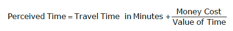
Suitable values of time for trip purpose can be found in the Appraisal Parameters Section 9.4.12.
11.6.3 Calculating Accessibility Measures and Presenting Results
There are three main methods available for weighting the perceived travel time to calculate the accessibility measures:
- Thresholds defining appropriate travel time cut off points;
- Weighting opportunities using factors according to time bands representing the perceived deterrence of travel; and
- Using a deterrence function to weight the available opportunities.
The complexity of the calculation approach needs to be appropriate for the policy decisions needed. Thresholds can greatly simplify calculation, but it needs to be noted that thresholds will not generally be representative of real travel behaviour. This can be overcome by the use of multiple thresholds with a narrow banding between them.
Mapping of thresholds provides a powerful visual representation of the impacts of transport options, which can support qualitative comments within the AST.
For quantitative measures, it is necessary to weight opportunities within each threshold to derive composite measures. The weights used need to reflect the perceptions of different people groups for travel for different trip purposes. Table 11.2 shows the factors which can be used. These factors have been based on an analysis of Scottish Household Survey data for Strathclyde Passenger Transport Executive covering the SPT area. Local surveys should be used in preference to these values where practical. This will be of particular importance in remote areas where perceptions of travel time may differ substantially from national averages.
It can be seen from the Table 11.2 that for travel to work by public!transport about 75% of people would be prepared to travel 20 perceived (i.e. including fares, effort) minutes, but only 40% would be willing to travel 60 perceived minutes. By weighting the opportunities that fall within each time band by the relevant factor, the accessibility index can be calculated for the total number of opportunities. Changes in these indices for the relevant people groups and trip purposes can then be included in the appraisal summary table.
| Travel time (mins) | Weighting Factor by Trip Purpose (Mode/Gender) | |||
|---|---|---|---|---|
| Work (PT) Education (PT) |
Shop (PT) Leisure (PT) Health (PT) |
Work (car/men) | Work (car/women) Shop (car) Leisure (car) Health (car) |
|
| 0-5 | 1 | 1 | 1 | 1 |
| 5-10 | 0.93 | 0.92 | 0.91 | 0.89 |
| 10-15 | 0.84 | 0.81 | 0.77 | 0.73 |
| 15-20 | 0.77 | 0.70 | 0.65 | 0.59 |
| 20-25 | 0.71 | 0.64 | 0.57 | 0.51 |
| 25-30 | 0.66 | 0.58 | 0.50 | 0.44 |
| 30-35 | 0.61 | 0.52 | 0.44 | 0.38 |
| 35-40 | 0.57 | 0.47 | 0.39 | 0.32 |
| 40-45 | 0.53 | 0.43 | 0.35 | 0.28 |
| 45-50 | 0.49 | 0.39 | 0.30 | 0.24 |
| 50-55 | 0.45 | 0.35 | 0.27 | 0.21 |
| 55-60 | 0.42 | 0.32 | 0.24 | 0.18 |
| 60-65 | 0.39 | 0.29 | 0.21 | 0.15 |
| 65-70 | 0.36 | 0.26 | 0.18 | 0.13 |
| 70-75 | 0.34 | 0.23 | 0.16 | 0.11 |
| 75-80 | 0.31 | 0.21 | 0.14 | 0.10 |
| >80 | Extrapolate as appropriate | |||
The third method represents the deterrence of travel as a continuous function eliminating the need for any thresholds or banding. The accessibility measures are therefore calculated as follows:
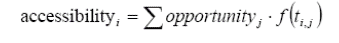
where i accessibility is the calculated level of accessibility at location i, j opportuniyt describes the opportunities available in zone j, ij t is the measure of perceived cost between zones i and j, and ( ) ij f t is a function representing the proportion of people willing to accept that cost.
This approach has been automated within accessibility modelling as discussed in Section 17.3. Once indices have been calculated for the relevant locations or zones the results are best plotted on maps using GIS approaches. Changes in accessibility measures as a rerult of transport investment can then be easily observed.
The cumulative accessibility change for all locations should be reported in the AST for the relevant trip purposes and people groups.
11.6.4. Impact of changes to Park and Ride on Demand at Railway Stations
Park and ride refers to car parking facilities connected to public transport, allowing travellers to travel by car and park, before continuing their journey via public transport. Rail passenger numbers continue to increase in Scotland, and coupled with worsening road congestion, this has improved the competitiveness of rail versus other modes.
As a result, the availability of parking has reduced with many station car parks full before the end of the AM peak period. If parking is not available, there is a perception that some may choose to make their entire journey by car rather than use rail. Alternatively, the length of the access leg by car could be extended if there is a lack of parking at some stations.
A number of benefits can be associated with an increase in the number of parking spaces at railway stations, helping to meet objectives such as:
Economic: the number of people able to access city centre employment will increase, given the speed and capacity characteristics of rail versus other modes. This could lead to increased demand for rail.
Environmental: rail transport has significant potential to lower CO2 emissions through modal shift from car.
Social: by encouraging some motorists to switch modes for at least part of their journey, this will reduce congestion levels and deliver other qualitative benefits, including improved quality of life and amenity.
Modelling outputs indicated that a 10% increase in parking spaces would lead to a 0.43% increase in season ticket trips and a 0.35% increase in non-season ticket trips if the car park is currently at or close to capacity, though there would be virtually no increase in non-season ticket demand if there are ample free alternatives to the station car park.
Analysis of case studies suggests each additional 100 parking spaces generates between 4 and 10 extra journeys per day. The findings from these case studies could be applied to other stations only with due attention to local circumstances, given that the demand impact will vary according to the specific characteristics of each station.
As such, it should be noted that while this is a useful initial rule of thumb, impacts will vary depending on a number of factors including availability of alternate on street or off street parking, attractiveness of destination for travellers (including employment opportunities), and constraints on car parking at the destination, and that such factors should be investigated.
Stakeholder feedback and primary research suggest that CCTV, lighting and tarmac (rather than dirt) roads are an integral part of the overall station design in terms of encouraging users, and these features should be taken into account when the assumptions are made on the number of rail trips generated relative to the number of parking spaces. The absence of these ‘complementary factors’ would reduce the attractiveness of any park and ride facility.
In terms of decongestion and environmental benefits, evidence has suggested that the impact here is negligible. While some travellers may choose to use rail for a proportion of their journey as a result of increased availability of parking spaces at stations, evidence suggests that this is offset by travellers previously walking/cycling/using other means of public transport to travel to the station now choosing to drive and park at the station. As such, it is recommended that decongestion and environmental impacts of changes to park and ride facilities not be monetised, though it may be prudent to qualitatively assess these impacts depending on the scenario.
Concerning price of parking, it is recommended that it be assumed that an increase of £1 in the cost of parking (from free to £1, £1 to £2 etc.) rail demand would be reduced by 4.9% or just 3.0% if there is ample free local parking near to the station.
The capital cost and any maintenance/operating costs of the parking spaces should also be included in the appraisal. The capital cost of extending existing car parks is about £5,000-£10,000 per space, although this could be higher if decking is required. The revenue stream that could be generated from additional rail passengers would be insufficient to provide a financial pay-back in less than 10 years, though there may be instances when this is possible. This capital cost is also indicative and will clearly vary according to location, so local costings should be used where available.
Local accessibility by walking and cycling can be significantly affected by transport investment, particularly where walking routes are severed by roads or railways, or when pedestrian priority, or new walking and cycle routes, are proposed. These changes can be measured as indices of walking and cycling access to local services as follows:
- Origin Accessibility - Assessment of the opportunities for an individual or a small group of households for access to local schools, shops, health centres or other facilities. Indicators such as floor space, number of jobs, or numbers of facilities of a particular type are normally used to measure this element.
- Destination Accessibility - Determining the walk in catchment to a facility such as a local shop, health centre, employment centre, school or for public transport. This element will usually be measured as the number of people or households affected, sometimes taking account of different population sectors.
Quantitative assessment of impacts can relatively easily be undertaken by using GIS mapping techniques. Capacity is rarely an issue for these routes but the quality of the routes, particularly where crossings of busy roads are involved, is an important factor. Accessibility measures based upon simple thresholds give a good indication of the opportunities available. The drive time calculation facilities in most GIS systems can be used to calculate walking times on roadside footpaths by setting the travel speed to an appropriate speed for walkers. Default networks in most GIS packages cover only roads so off road routes need to be added. Other factors can be added to modify the networks or network speeds such as time penalties for road crossings based on the road traffic flow, and reductions in this where pedestrian crossing facilities are installed. A similar approach applies for cycling but the speeds are faster.
Where more refined analysis is needed, effort is best directed at qualitative analysis working with local people, including existing and potential pedestrians and cyclists, to identify how problems or perceived problems can be overcome. Such approaches are becoming increasingly common within modern community planning agendas, such as safer routes to school initiatives, healthy living centres, and Community Planning Partnerships and transport scheme appraisal can usually draw from the issues identified as part of these processes.

In determining catchments for the calculation of the walking and cycling measures the criteria in Table 11.3 can be used as a general guide.
| Aspect of travel | Time and (Distance) |
|---|---|
| Walking to facilities | 20 mins (1.4 - 1.6 km walk) |
| Walking to bus stop (urban) | 5 mins (300 - 500 metres walk) |
| Walking to bus stop (rural) | 10 mins (600-1000 metres walk) |
| Walking to railway station | 10 mins (600-1000 metres walk) |
For cycling thresholds and times the distances will be typically two or three times the values for walkers. However these aspects of cycle behaviour are not as widely researched as for walking, so if observed local behaviour is different this should be used in preference. Acceptable walking times will be lower where there is no dedicated footway. Walking distances will also be highly dependent on topography and other factors.
The main barriers to walking and cycling include crossing major roads, local topography, or passing through areas perceived to be dangerous. Table 11.4 suggests criteria that could be used in calculating accessibility measures, but local expectations vary. The consultation on transport options should therefore seek to identify traffic flow levels perceived as barriers and local topographic and local community safety barriers.
| Barrier | Value for significant barrier |
|---|---|
| Walking | |
| Significant traffic barrier (traffic flow) | Above 9,000 - 12,000 vehicles per day |
| Slight barrier | 2,000 to 9,000 vehicles per day |
| Quiet road | Below 2,000 vehicles per day |
| Cycling | |
| Road considered unsafe (2 lane <3m width) | 10,000 vehicles per day |
| Road considered unsafe (wider road) | 20,000 vehicles per day |
| Road speed considered too fast (2 lane <3m width) | 40 mph limit |
| Road speed considered too fast (wider road) | 50 mph limit |
11.8 The Distribution of Impacts by People Group
The need to consider the distribution of impacts is emphasised by the challenges faced in delivering transport investment. Most objections to transport change are from people who feel that they are not being treated fairly or that their needs are not being met in some way. Accessibility measures describe transport provision as it is viewed by users, so measures of the distribution of impacts by people group are helpful in demonstrating that planned transport changes impact fairly on all sections in society by: age group, socio-economic status, gender, ethnicity, and mobility status.
The exact choice of people groups will depend on the local policy sensitivity but for all options a comparison should be made between car available and non-car available trips.
It will also be important to compare impacts for unemployed people/job seekers relative to the total population in many cases. Appraisals should also confirm that there is no bias in the balance of investment by age, ethnicity, religion, or gender.
Indices of accessibility should have been calculated for the public transport network coverage appraisal so the distributional appraisal should use this analysis to compare accessibility change for different people groups.
By using ratios or maps to compare changes in accessibility measures for specified population groups or geographical areas the findings of the accessibility analysis can be quantified. For example:
- The change in the aggregate ratio of car accessibility to PT accessibility helps to show whether public transport investment encourages efficient mode choice within multi-modal plans; and
- Ratios of the impacts on socially excluded groups to the population as a whole can show whether options are consistent with social inclusion policy.
It should be noted that the ratio of car available accessibility to non-car available accessibility will always be greater than 1. Non-car available trips have higher perceived travel times than car available trips, since the car available people have an additional mode available to them (i.e. the car) which can be used when it is faster than public transport. In the same way, mobility impairments will increase perceived travel times relative to fully mobile people. The purpose of the STAG Appraisal will be to demonstrate that the implications for all people have been considered, and that interventions are consistent with policies for Social Inclusion.
11.9 The Distribution of Impacts by Location
It is important to understand the locus of impact of transport investment. This is particularly important when assessing packages of schemes such as local transport strategies, major network changes, forward investment programmes, or the impacts of generic policies such as for fares subsidies or fuel cost changes.
Calculation of accessibility location impacts can help to inform the appraisal in Section 9 for the Economic Activity and Location Impacts (EALIs). However to avoid double counting, reporting of results under the accessibility appraisal should be confined to social rather than economic factors.
The choice of sensitive locations will depend on the projects or policies being considered but as a minimum the analysis should compare the impacts on designated areas of deprivation such as Community Planning Partnership (CPP) areas or priority partnership areas.
Impacts on Places - Prestwick Airport Catchment Area
The following maps have been created using TMfS and TELMOS.

Map 1 illustrates how many businesses are within the effective catchment of Prestwick Airport if travelling by car during the inter-peak period for 2005.
The distribution of employed people is used as a proxy for business activity as derived from TMfS/TELMoS and according to the following scale:
| Very low: | 0-200 equivalent jobs. |
| Low: | 200-500 equivalent jobs |
| Average: | 500-1,500 equivalent jobs |
| High: | 1,500-10,000 equivalent jobs |
| Very High: | 10,000-30,000 equivalent jobs |
'Equivalent Business' is a measure of business activity across Scotland factored according to ease by which it can reach Prestwick Airport (expressed in terms of a journey time deterrence function) from a given location.
According to this definition, areas regarded as having high levels of equivalent business in the Airport catchment include the Irvine, Kilmarnock and Ayr coastal areas. Ease of access to the nearby Airport as well as high levels of real business activity will be fundamental drivers attributing to this categorisation. Other notable locations with high levels of real business activity that exhibit the characteristic of enjoying good access to the Motorway network include Central Glasgow, Grangemouth/Falkirk, Livingston, and West Edinburgh.
Zone 217 was chosen as an example to illustrate changes in the provision of employment. When zone 217 (Livingston), near the M8, is factored by the journey deterrence function there is a decline in accessibility to jobs within the Prestwick Airport catchment from ~11,000 to ~5,000.

Map 2 shows the geographical distribution of equivalent business activity excluded from the Prestwick Airport catchment. This is the difference between real business activity and the equivalent business activity shown in map 1. For the Livingston zone 217, this shows a level of business 'exclusion' equivalent to ~6,000 employed people ('High').
The journey deterrence technique provides a useful measure for highlighting where the greatest potential for improving business access to key hubs lies. This in turn helps to direct where transport interventions can provide the greatest benefits to business thereby improving Scotland's economic performance.
Weighting accessibility measures by the affected population is often needed where modal shift is anticipated. For example, when looking at the impacts of road charging, accessibility analysis can identify the accessibility disbenefits for car available households in each location from paying the charge. This can be compared with the accessibility benefits for all households from the associated public transport investment package, funded by the road charging revenue. By looking at the impacts on people rather than modes, this process can be used to identify whether or not all locations are being treated fairly in the design of the charging scheme and associated public transport investment.
The results of the social location impacts can be presented on maps, graphs or as composite indices for different categories of location, as illustrated by the example above.
11.10 Summary of Accessibility Measures in AST
The scope and flexibility of the alternative analysis approaches brings an even wider range of potential ways to present the results. In some circumstances a single value in the Appraisal Summary Table will be possible for each strand of the Accessibility and Social Inclusion Appraisal. In other circumstances, map based presentation will be the only useful way to present the results.
| Criterion | Qualitative Information | Quantitative Information |
|---|---|---|
| Community Accessibility | ||
| Public transport network coverage |
|
|
| Access to local services |
|
|
| Comparative Accessibility | ||
| The distribution of impacts by people group |
|
|
| The distribution of impacts by location |
|
|
11.11 Participation and Consultation
With a focus on people and places rather than modes of transport, consultation should be integral to the appraisal of the impacts of an option on Accessibility and Social Inclusion. This is of particular value to the accessibility analysis completed in that the opportunity is presented to capture both real and perceived accessibility issues. Coverage should be wide ranging and focus on people and places rather than modes of transport. A range of methods can be used and the selected approach should be fully reported.
A presentation of results should be given in the Part 2 AST with supporting information provided to outline the main impacts identified.
The Accessibility and Social Inclusion Criterion has four sub-criteria: Public Transport Network Coverage, Local Accessibility, distribution of impacts by Social group, and distribution of impacts by Geographic location. A wide range of methods can be used to calculate these indicators and the selected approach should be described in the summary report.
Accessibility and social inclusion findings can be much easier to understand when presented on maps. Access to local services can summarise impacts for relevant services separately or collectively for a range of services in local centres such as towns and villages. If walking and cycling routes are unaffected then this should be stated in the summary. The different options available for presenting Accessibility and Social Inclusion results for each of the sub-criteria considered are described here. These should be included in the STAG Report and presented clearly and concisely.
Summaries of the distribution of impacts on places and people should be consistent with the level of detail for assessing absolute levels as discussed above. Graphs are useful ways of showing comparisons of impacts for different locations and people groups.