The Proposed Scheme
Need for the Scheme
The A9 is a strategic route linking central Scotland to the north of Scotland, used by both local and long-distance traffic. It is a major bus route and is used by freight traffic supporting key industries, such as food and drink, oil, waste and construction. The route is used by tourists as a means of reaching locations in Perthshire and the Highlands. It is considered that the upgrade of the A9 to dual carriageway will help assist economic growth in the north of Scotland. The A9 Dualling will improve journey times and journey time reliability, potentially saving costs for businesses, reducing driver stress and improving safety; and potentially making the surrounding areas more attractive as a short-term tourism destination.
The national context for the need for the proposed scheme has been identified within several national strategies and policy frameworks as an important national infrastructure scheme. This includes the National Transport Strategy (NTS) of 2006 (Scottish Executive, 2006); the Strategic Transport Review (STPR) in 2009, (Transport Scotland, 2009); the Infrastructure Investment Plan in 2011 (Scottish Government, 2011) and through National Planning Framework (NPF) 3 (Scottish Government, 2014) in 2014 and NPF4 (Scottish Government, 2023) in 2023. Therefore, at a national level, the proposed scheme is supported within several national strategies, in particular it aligns with the vision for Scotland’s transport system for the next 20 years, as set out in NTS2 (Transport Scotland, 2020) and the long term spatial strategy provided in NPF4 to maintain a resilient road link from Inverness to Perth.
Local context considerations also support the need for the proposed scheme, supporting objectives set out in local policy such as in Perth & Kinross Council (PKC) Local Development Plan (LDP) 2 (Perth & Kinross Council, 2019) in relation to delivering sustainable economic growth and promoting the delivery of local and strategic transport infrastructure to support sustainable development, including of the wide range of businesses, tourist attractions and recreational activities found in the local area.
The proposed scheme also addresses safety issues for road users (accidents and driver stress). The existing A9 is used by a combination of different vehicle types with the mix of usage leading to relatively higher levels of driver stress. This is particularly acute during the summer months and holiday periods with long waiting times at at-grade junctions and lack of safe overtaking opportunities, both of which have led to some serious accidents including fatalities. There is also a lack of alternative diversion routes, which causes severe delays when accidents do occur. The latest accident statistics, including for the proposed scheme, are set out in the A9 Dualling Programme Outline Business Case (Transport Scotland, 2023b).
Scheme Objectives
The aim of dualling the A9 between Pass of Birnam and the Tay Crossing is to improve the operational performance and safety of this section of the A9, building on and contributing to the objectives set for the overall A9 Dualling Programme.
The STPR assessment of issues and improvement opportunities along the existing A9 led to the development of the A9 Dualling programme objectives set by Transport Scotland, which are:
- To improve the operational performance of the A9 by:
- reducing journey times; and
- improving journey time reliability.
- To improve safety for motorised and non-motorised users through:
- reducing accident severity; and
- reducing driver stress.
- To facilitate active travel within the corridor.
- To improve integration with Public Transport facilities.
The environmental assessment process facilitates these objectives to be met whilst avoiding and/or reducing environmental effects, enhancing the environment and improving sustainability where possible. This is done through the inclusion of appropriate environmental measures, adherence to best practice during construction and measures ‘embedded’ into the design such as new footways to improve existing facilities and connectivity.
Alternatives Considered
In 2004, a Route Improvement Strategy Study (RISS) (Scott Wilson, 2004) for the new A9 trunk road between Perth and Blair Atholl was undertaken, which recommended upgrading the A9 between Perth and Pitlochry to dual carriageway standard. In 2009, the Pass of Birnam to Tay Crossing section of the scheme considered an online corridor for a dual carriageway, with offline corridors discounted due to adjacent topography (an off-line route to the east would involve significant tunnelling works through Craig-a-Barns, and an off-line route to the west would involve significant tunnelling through Birnam Hill).
Subsequent assessment of five alternative scheme options was not concluded and no recommendations were provided due to the need to undertake further consultation. A Strategic Environmental Assessment (SEA) was then undertaken of the A9 Dualling Programme from 2012 to 2014, which considered environmental constraints, issues, risks and opportunities associated with alternative approaches to achieving the broader scheme objectives. The SEA was completed in parallel with a similar consideration of engineering constraints, issues, risks and opportunities as part of a Preliminary Engineering Services (PES) commission.
Three high-level, strategic alternative dualling options were considered within the SEA for the A9 Dualling programme: online widening, a combination of online widening and offline dualling at more constrained locations, and complete offline dualling. The studies identified that online widening following the route of the existing A9 was the most suitable option.
As part of the A9 PES study, the A9 between Perth and Inverness was sub-divided into six sections (Sections A-F), with Pass of Birnam to Tay Crossing falling into Section A (Inveralmond to Tay Crossing). Sectioned indicative corridor options were considered within each of the sections, with those of geographic relevance to the proposed DMRB Stage 3 Pass of Birnam to Tay Crossing scheme comprising:
- Option A1: Online dualling between Inveralmond to Tay Crossing.
- Option A3: Online dualling to Bankfoot and thereafter offline to the south of Birnam Hill.
- Option A4: Online dualling to Bankfoot and thereafter offline to south of railway line and existing trunk road.
- Option A5: Online dualling to Pass of Birnam and thereafter offline to north of Dunkeld and Birnam.
- Option A6: Online dualling to Pass of Birnam and thereafter offline to south of railway line and existing trunk road.
Following further consideration at a sifting assessment workshop in January 2013, attended by Transport Scotland, it was agreed that Options A2, A3, A4 and A5, all of which would require a significant length of offline works with resulting environmental impacts, were significantly less advantageous than the on-line Option A1. Dualling via alternative routes to the existing A9 to provide the most direct route between the two cities (Option A: Perth to Inverness) irrespective of any constraints, was also discounted. As a result, Option A1 was to be progressed for further assessment for this section of the A9 Dualling programme.
The PES commission also developed a broad strategy for the treatment of existing junctions and accesses along the A9.
In accordance with the A9 Junctions and Accesses Strategy, it was further stated that grade separated junctions be provided at:
- Birnam, where the A9 meets the B867 and Perth Road;
- Dunkeld, where the A9 has existing junctions with the A923 and A822; and
- Dalguise where there is an existing junction with the B898.
Further work was undertaken to address issues including access to Dunkeld & Birnam Station for vehicular traffic and constructability within a constrained corridor. This led to the development of three options that followed the same horizontal alignment and differed only in vertical alignment within the central section of the route, in the vicinity of Dunkeld & Birnam Station. Each had variations of junction arrangements at Birnam Junction, Dunkeld Junction and Dalguise Junction. Two options proposed to re-locate Dunkeld & Birnam Station north of the Inchewan Burn with access provided via the A822. The third option had the mainline lowered in the vicinity of Dunkeld & Birnam Station to facilitate access to the station and replacement car parking above the mainline via Station Road.
The three options (Options A, B and C) were presented to the public at an exhibition in January 2016 and discussed at a public meeting in February 2016. Feedback was requested from the community and concerns were raised as to the scale of the proposals, particularly the grade separated junction layouts. Dunkeld & Birnam Community Council requested more detailed consultation be undertaken with the local community to review the options and investigate if other suitable alternative options, that address community concerns, were available. As a result, Transport Scotland agreed to an A9 Co-Creative Process, a collaboration between the community and Transport Scotland and its consultants, to identify and consider a variety of route options and scheme elements for the proposed scheme.
Following a series of community workshops in 2017, a series of community objectives were generated:
- Reduce current levels of noise and pollution in the villages of Dunkeld, Birnam and Inver to protect human health and well-being of residents and visitors and to enable them to peacefully enjoy their properties and amenity spaces.
- Protect and enhance the scenic beauty and natural heritage of the area and its distinctive character and quality.
- Provide better, safer access on and off the A9 from both sides of the road while ensuring easy, safe movement of vehicular traffic and NMUs through the villages, helping to reduce stress and anxiety and support the local community.
- Promote long-term and sustainable economic growth within Dunkeld and Birnam and the surrounding communities.
- Examine and identify opportunities to enhance the levels of cycling and walking for transport and leisure, including the improvement of existing footpaths and cycle ways, to promote positive mental health and well-being.
- Ensure that all local bus, intercity bus services and train services are maintained and improved.
- Preserve and enhance the integrity of the unique and rich historical and cultural features of the Dunkeld, Birnam and Inver communities, thereby supporting well-being and the local economy.
The subsequent A9 Co-Creative Process consisted of the following five stages:
- Stage 1: Community Options Gathering
- Stage 2: Developing an All-Candidate Option List
- Stage 3: Creating a Long List
- Stage 4: Selecting a Short List
- Stage 5: Agreeing a Community Preferred Route Option
By the end of Stage 4, four whole route options that were selected for final voting were:
- three ‘online’ routes (Routes A, B and D) which would follow the line of the existing A9 (but partly at lower level involving a cut and cover tunnel or underpass) with junctions at Dunkeld, Dalguise and the Hermitage, and the retention of the Dunkeld & Birnam Station; and
- one ‘offline’ route (Route C) which consisted of a 2.8km tunnel to the west of the existing A9 with junctions at Dalguise and the Hermitage, and the retention of the Dunkeld & Birnam Station.
The online options had varying lengths of tunnel with Route A incorporating a 1.5km tunnel, Route B a 450m tunnel and Route D an underpass of up to 150m. To complete the whole route, three options for junctions at the Birnam and Murthly Castle end of this section were also offered:
- a restricted movement grade-separated junction at Birnam;
- a full movement grade-separated junction adjacent to the current access at Murthly Castle; or
- a roundabout at Birnam.
Over the voting period, between 23 June and 2 July 2018, 720 people voted online or submitted voting cards. Voting was open to the public and the number of votes received represented a very strong turnout relative to the size of the community. The rankings were aggregated into total scores for each of the four short-listed routes to determine the Community’s Preferred Route Option (CPRO).
The online route (Route A) incorporating a 1.5km tunnel commencing in the area of the existing junction of the A9 with the B867 and Perth Road at Birnam and terminating in the area of the existing junction with the A923 and A822 at Little Dunkeld came out on top with the highest score, attracting 37.4% of the total of all scores across the four routes and also attracting 45% of the first place votes recorded. Routes B, C and D attracted 23%, 22.3% and 17.3% of the total of all scores respectively. The CPRO was announced on 13 August 2018.
Following completion of the A9 Co-Creative Process, initial assessment was undertaken on the CPRO. This work considered environmental, constructability and economic impacts and identified a number of key challenges. As a result, three Additional Whole Route Options were developed, and these were to be considered alongside the CPRO as part of the DMRB Stage 2 assessment (options appraisal stage) of the proposed scheme. The four Route Options considered were:
- CPRO (Option ST2A) with A9 dual carriageway lowered into a 1.5km cut and cover tunnel structure. Grade separated junctions at Murthly and Dalguise and an at-grade roundabout at Dunkeld. Dunkeld & Birnam Station Replacement Car Park on cut and cover tunnel with direct access to Birnam from Station Road.
- Additional Whole Route Option 1 (Option ST2B) with A9 dual carriageway lowered into a 150m underpass structure. Grade separated junctions at Birnam and Dalguise and an at-grade roundabout at Dunkeld. Dunkeld & Birnam Station Replacement Car Park on underpass with direct access to Birnam from Station Road.
- Additional Whole Route Option 2 (Option ST2C) on-line route, largely following the horizontal and vertical alignment of the existing A9 single carriageway. Grade separated junctions at Birnam, Dunkeld and Dalguise. Dunkeld & Birnam Station Replacement Car Park off Station Road and Pedestrian Underpass under the main alignment providing access to Dunkeld & Birnam Station.
- Additional Whole Route Option 3 (Option ST2D) on-line route, largely following the horizontal and vertical alignment of the existing A9 single carriageway. Grade separated junctions at Birnam and Dalguise and an at-grade roundabout at Dunkeld. Dunkeld & Birnam Station Replacement Car Park off Station Road and Pedestrian Underpass under the main alignment providing access to Dunkeld & Birnam Station.
Following further consultation with the Birnam to Ballinluig A9 Community Group in late 2019, further consideration was given to an option that incorporated a 450 metre long cut and cover tunnel, which was originally developed through the A9 Co-Creative Process.
It was concluded however, that although it had a reduced length of tunnel, the option would still have significant construction complexity, similar to the CPRO (Option ST2A), with an estimated construction duration of between 4 and 4 ½ years. Furthermore, it would also impact local watercourses and not fully address concerns noted from some local residents and stakeholders.
On the basis of the DMRB Stage 2 Route Option Assessment, the Emerging Preferred Route Option (Additional Whole Route Option 3 (Option ST2D)) was recommended to be taken forward as the preferred route for the proposed scheme. This was presented to Scottish Ministers for consideration. As this was different to the CPRO, (Option ST2A), this was presented to Scottish Ministers alongside the CPRO, as agreed as part of the A9 Co-Creative Process. The key reasons to support the recommendation of Option ST2D as the preferred route were as follows:
- The Emerging Preferred Route Option (Option ST2D) includes the community’s favoured options, as voted through the A9 Co-Creative Process, at Dunkeld, The Hermitage and Dalguise.
- In addition, the junction option at Birnam is based on the principle of the community’s second preference for a junction, which was a grade separated junction, restricted movements junction with a northbound diverge slip road and a southbound merge slip road only. However, to partly address traffic increases on Perth Road with such an option, a northbound merge slip road was added.
- The Emerging Preferred Route Option (Option ST2D) also incorporates improved access to the station, with the opportunity to enhance further, which was noted as important to the local community.
On 20 December 2023, Option ST2D was confirmed by the Scottish Ministers as the Preferred Route Option for the proposed scheme.
Iterative Design Development
The DMRB Stage 3 design for the proposed scheme is the result of approximately 18 months of design development of the preferred route option that was identified on completion of the DMRB Stage 2 assessment (Transport Scotland, 2023).
The project environmental team has influenced the design based on knowledge gained through the EIA process, working closely with the engineering teams, consultees, and Transport Scotland. Through this process, the design has been iteratively updated from the Preliminary Design to reach the refined DMRB Stage 3 Design Fix assessed in the EIAR.
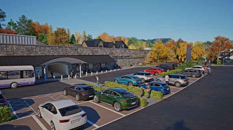
A key consideration in reaching the final DMRB Stage 3 design was the development of the design to avoid any increase in flood risk at key receptors (properties and infrastructure) and the development of the design for Dunkeld & Birnam Station and the Dunkeld & Birnam Station Replacement Car Park and Pedestrian Underpass.
Flood modelling during the development of the preliminary and interim designs highlighted the potential for increased flood risk in the area around Inver where the River Braan and the River Tay meet. Initial designs included two compensatory flood storage areas and more than 20 flood relief culverts. Design development of the River Braan Bridge and the main alignment embankments and WCH provision (provision for walkers, wheelers, cyclists and horse-riders) in the section between the River Braan and Inver allowed the rationalisation of flood mitigation to one compensatory flood storage area and 14 flood relief culverts.
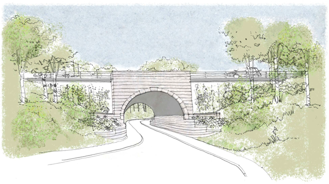
During the iterative design development process, in light of the ongoing proposals of Network Rail in respect of accessibility to and around Dunkeld and Birnam Station, it was identified that the pedestrian underpass proposed as part of the proposed scheme should make provision for step free access to and between both Platform 1 and Platform 2 of Dunkeld & Birnam Station, by extension of the pedestrian underpass under the Highland Main Line railway to Platform 2 and provision of lifts and stairs to both platforms. The design of the Dunkeld & Birnam Station replacement car park, the associated pedestrian underpass, and the platform level buildings containing lifts and stairs, has therefore been developed and refined – an artist’s impression of the proposals can be seen in Image 1.
Some of the other key design considerations during DMRB Stage 3 design development that avoided or reduced the potential impacts include:
- reducing loss of designated areas (River Tay SAC) for example by using retaining wall structures for local access and to protect road infrastructure;
- reducing potential impacts and effects on Key Landscape Features and Special Features of the Murthly Castle Garden and Designed Landscape through design of Murthly Estate Bridge; location, orientation and design of two of the proposed scheme’s drainage elements (Sustainable Drainage Systems (SuDS) Basin A and SuDS Basin B2); and development of Birnam Junction;
- reducing/avoiding where practicable the loss of native and ancient woodland through design and providing compensatory planting, including off-site planting;
- reducing impacts on the River Tay floodplain through for example road drainage design, flood relief culverts and provision of compensatory flood storage; and
- drainage design to reduce impacts on the floodplain, habitats and River Tay SAC and whether each SuDS feature should be a dry detention basin or a pond.
Other measures embedded in the proposed scheme include noise attenuation through the use of low noise road surfacing and noise barriers. Woodland planting is also included to integrate the proposed scheme into the landscape and compensate for woodland loss as a result of the proposed scheme. Where planting is specified, native plant species will be used so as to re-establish or reinforce the character of the landscape.
The Proposed Scheme
An outline design has been developed for the proposed scheme, which is referred to as the ‘DMRB Stage 3 design’. This design would be used by the appointed contractor to prepare a detailed design for construction of the proposed scheme.
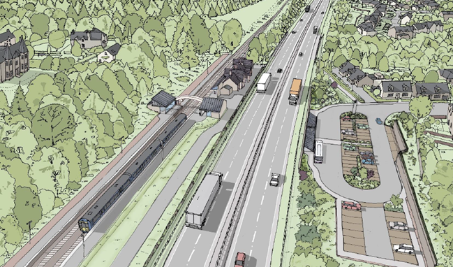
The proposed scheme commences at Pass of Birnam and extends northwards for approximately 8.4km, terminating beyond the Tay Crossing. This section of the A9 is located within close proximity to a number of designated environmental sites, including watercourses forming part of the River Tay Special Area of Conservation (SAC), which are crossed by the existing A9.
The proposed scheme extents are illustrated on Insert A, and the DMRB Stage 3 Design and key environmental features in and around the area of the proposed scheme are illustrated at the end of this document on Figures 1-6. References are made to chainages (shortened to ‘ch’), which is a reference to the number of metres from the start of the proposed scheme, from south to north.
A9 Mainline Carriageway Widening
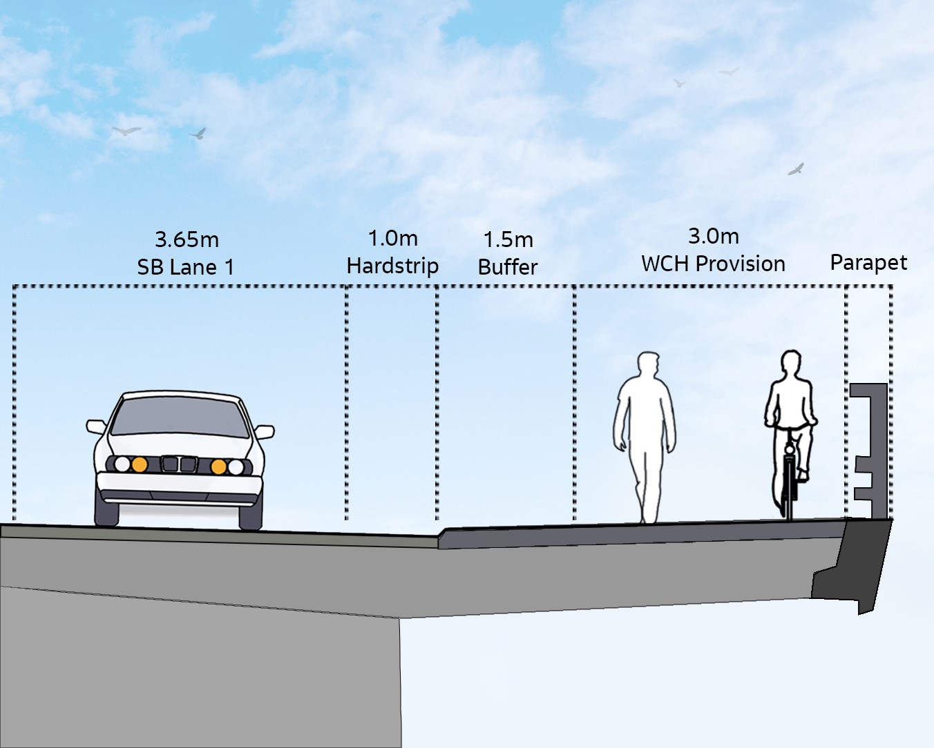
The mainline will comprise of a dual carriageway with minimum 2.5m verges and two lanes of 3.65m width in each direction, plus a 1m hardstrip to both the nearside and offside lanes in each direction and a typically 2.5m wide central reservation separating each carriageway. Both the verges and central reserve will be widened as necessary for visibility.
The Proposed Scheme Extents
The existing A9 mainline has several direct accesses linking to side roads and to land and properties along the route, most of which will be removed to meet the desired design and safety standards for the upgraded route, with alternative access being provided by two grade separated junctions, an at-grade roundabout, three at grade left in/left out junctions, and via the existing side road and access track network.
A9 Junction Provision
Two grade separated junctions are included as follows:
- The Birnam Junction (ch1900) replacing the existing at-grade junction and providing a northbound merge, a northbound diverge and a southbound merge facilitating connection to the B867 and Perth Road.
- The Dalguise Junction (ch6800) replacing the existing at-grade junction and providing a northbound merge and diverge loop, a southbound merge and diverge facilitating full vehicle movement and connection with the B898.
It should be noted that the Dalguise junction will facilitate junction movements that, prior to construction of the proposed scheme, will be provided by the A9 Southern Tie-in Interim Roundabout on the Tay Crossing to Ballinluig project. This interim roundabout will be removed as part of the proposed scheme.
The Dunkeld Junction at-grade roundabout (ch4100) replacing the existing at-grade junction will facilitate connection to the A9 (north and south), A923, A822 (Old Military Road) and the Unclassified Road to Inver, and includes a segregated left turn lane from Dunkeld and Birnam via the A923 to the A9 southbound.
There are three left-in left-out junctions on the main alignment to be provided as part of the proposed scheme, as follows:
- A left-in left-out junction (ch3000 northbound) replacing the existing at-grade junction to Dunkeld & Birnam Station, providing only maintenance access to Dunkeld and Birnam Station Building and Network Rail assets, including the signalling box and the road/rail access point.
- Upgrade of the existing access to The Hermitage with the Hermitage left-in left-out junction (ch5200 northbound) providing access to the National Trust for Scotland beauty spot and car park.
- A new left-in left-out junction for the Inver Maintenance Access (North) (ch5500 southbound) providing access to SuDS features and farmland.
Side Road Amendments/Upgrades
Side roads will be upgraded as necessary to provide access from the existing road network to the mainline of the proposed scheme. Upgrades may involve simple resurfacing or may require realignment and other improvements.
Revised accesses to private property including farms, farmland and woodland located along the proposed scheme will tie into the existing road network or onto the A9 main carriageway via the grade separated, at-grade junctions and side road amendments.
Provision for Walkers, Wheelers, Cyclists and Horse Riders
Existing and proposed walkers, wheelers, cyclists and horse rider (WCH) route alignments are included to support one of the objectives of the A9 Dualling to facilitate active travel within the corridor of the proposed scheme. The proposed scheme requires the realignment and provision of new paths at 25 locations. New provision is provided at 11 of these locations linking paths to the existing path network. These include new paths that link Birnam to Dalpowie adjacent to the River Tay; Birnam to Birnam Hill/Kings Seat via Perth Road and the B867; Dunkeld and Birnam to Inver crossing the River Braan; Dunkeld, Birnam and Inver to northbound and southbound replacement bus stops at Inver and new provision on the River Tay Bridge that provides better segregation for WCH from traffic and links to paths to the north and south banks of the River Tay.
Bus Stop Provision
Existing bus stops at Inver will be replaced by permanent bus stops (northbound and southbound) at similar locations on the main alignment, with connections provided to the existing bus stops on Perth Road. The opportunity for bus turning and bus stop facilities will also be provided at the Dunkeld & Birnam Station Replacement Car Park.
Bridges
There are 10 bridges in the proposed scheme:
- Murthly Estate Bridge (new structure providing access to Murthly Estate);
- Birnam Junction Bridge (new structure forming part of the Birnam Junction);
- Birnam Glen and Inchewan Burn Bridge (new structure supporting the main alignment crossing Birnam Glen and Inchewan Burn);
- River Braan Bridge (new structure for the main alignment with WCH provision crossing the River Braan);
- Inver Rail Bridge (extension to existing structure to cross the Highland Main Line railway);
- Dalguise Junction Bridge (new structure forming part of Dalguise Junction);
- Inverwood Access Track (North) Rail Bridge (new structure to allow vehicle and WCH access under the Highland Main Line railway);
- Inch Rail Bridge (extension to existing structure to cross over the Highland Main Line railway);
- River Tay Bridge (new structure for the southbound carriageway across the River Tay and incorporating provision for WCH); and
- River Tay Crossing (Jubilee Bridge) (existing structure maintained supporting the northbound carriageway).
Underpass Structures
The proposed scheme includes the Dunkeld & Birnam Station Pedestrian Underpass, which will connect the replacement car park at the top of Station Road to Platform 1 and Platform 2 of Dunkeld & Birnam Station. The underpass structure will include stairs and lifts to both platforms and be fully accessible for walkers, wheelers and cyclists.
Cuttings and Embankments
While the proposed scheme design aims to maintain a level as close to existing ground level as possible, where the carriageway is higher or lower than the surrounding ground level, embankments or cuttings are required. Reducing the gradient of embankments (referred to as ‘grading out’) has been considered along the route to reflect local landform and aspects such as surrounding land use or other environmental constraints. Similarly, cuttings have been designed to take account of their visibility for road users and others along the A9 corridor.
Fencing and Environmental Barriers
Temporary fencing will be erected prior to the commencement of construction where appropriate. Environmental barriers are required to reduce the potential impacts of the proposed scheme to provide mitigation for mammals (including otter and badger fencing) and for noise attenuation.
Drainage Design, Flooding and Watercourse Crossings
The drainage design for the proposed scheme has been developed in accordance with Sustainable Drainage Systems (SuDS) guidance and through consultation with SEPA and Perth & Kinross Council. In certain areas along the existing A9 there are lengths of filter drain in the verges that provide initial treatment for some of the run-off from the road and/or adjacent earthworks slopes. A minimum of two levels of water treatment through SuDS features (basins, ponds and swales) will be included for all mainline outfalls in agreement with SEPA. There will also be SuDS treatment of side road drainage.
The proposed carriageway drainage system is designed to be resilient to flood events. All run-off from the proposed scheme will be collected and treated via the proposed drainage system prior to discharge.
There are 16 existing watercourses that pass underneath the existing A9 carriageway, and these crossings will generally be extended or replaced in their current location. The proposed scheme includes 14 flood relief culverts located north of where the proposed scheme crosses the River Braan. These flood relief culverts, in combination with a compensatory flood storage area adjacent to the River Braan/River Tay confluence that mitigates for floodplain lost as a result of the proposed scheme, will mean that flood risk at key receptors (property and infrastructure) is not increased.
Traffic Signs and Lighting
Traffic signs are required for the proposed scheme, including the three main junctions at Birnam Junction, Dunkeld Junction and Dalguise Junction, and for other accesses such as the three left-in left-out junctions on the main alignment, including at The Hermitage.
The existing route is currently not lit, and generally from an environmental perspective it is preferable to avoid road lighting in rural areas, as lighting can increase visual intrusion at night. Lighting will however be provided on the at-grade roundabout at Dunkeld Junction and at the replacement Dunkeld & Birnam Station car park, and will be designed to be sensitive to key receptors such as residential properties and ecological receptors (e.g. bats) at these locations.
During construction of the proposed scheme, temporary lighting may be required where night-time and/or winter morning/afternoon working is necessary, to minimise traffic disruption/diversions/lane closures, and also along temporary access roads or other locations where temporary traffic management measures require lighting for safety reasons. Temporary lighting may also be required for security and safety reasons at site compounds during morning and evening working hours in winter.
Delivering the Proposals
The design of the project may be refined further by a contractor that will be appointed by Transport Scotland. The contractor that delivers the proposed scheme must meet the requirements of the environmental assessment. Should the contractor refine the design that has been assessed at EIA, environmental review of those refinements will be undertaken, and additional mitigation proposed where required to ensure that there are no additional significant effects.
Subject to completion of the necessary statutory processes, construction is anticipated to extend from winter 2028/29 to the end of 2032. Typical working hours have been assumed to be 07:30 to 18:00 Monday to Friday and 08:00 to 13:00 on Saturdays.
Overview of the Environmental Impact Assessment Process
The environmental impact assessment has been undertaken as an integral part of the design process, informing decisions on the proposals as they were developed. Environmental constraints and issues were identified and incorporated into the decision-making process throughout. Information gathered through the extensive surveys undertaken for the proposed scheme was used in the assessment.
The aims of the environmental impact assessment are to:
- gather information about the environment of the study area and identify environmental constraints and opportunities associated with the area which may influence, or be affected by the proposed scheme;
- identify and assess potential environmental effects;
- identify and incorporate into scheme design and operation, features and measures to avoid, reduce or offset adverse impacts and effects, or in some cases to enhance beneficial impacts and effects; and
- assess the proposed scheme’s residual effects (those remaining after measures are implemented to avoid or reduce potential impacts and effects).
Consultation and Scoping
As part of the design development and assessment process, a comprehensive consultation has been carried out with numerous stakeholders including Perth & Kinross Council, Historic Environment Scotland (HES), SEPA and NatureScot. In addition, potentially affected landowners were consulted. Public exhibitions and community engagement events were held in January 2024 and August 2024 as part of a programme of ongoing public engagement and consultation for the proposed scheme.
The purpose of the consultation was to:
- ensure that members of the public, statutory consultees, and other bodies with a particular interest in the environment were informed of the proposals and provided with an opportunity to comment;
- collate baseline information regarding existing environmental site conditions;
- obtain input to the identification of potential impacts and the development of appropriate mitigation;
- inform the scope of the assessments being undertaken; and
- seek consultee input to the proposed scheme design.
The project team has worked closely with key stakeholders to develop a proposed scheme that aims to reduce the overall environmental impact, for example, by avoiding sensitive features and through careful design. Stakeholder feedback was reviewed by the project team and incorporated into the assessment and design process where appropriate.