Volume 1, Chapter 12 - Biodiversity
PDF Version
Summary
This chapter considers the potential impact and associated effects of the proposed scheme on biodiversity resources including terrestrial and freshwater species, habitats and ecosystems. The approach to this assessment is based on the Design Manual for Roads and Bridges (DMRB) Guidance and draws on the Chartered Institute for Ecology and Environmental Management’s Guidelines for Ecological Impact Assessment in the UK and Ireland.
Baseline conditions for biodiversity resources were established through desk-based assessment, consultation and site surveys. This process identified biodiversity resources that could potentially be impacted by the proposed scheme, including the River Tay Special Area of Conservation (SAC), woodland identified on the Ancient Woodland Inventory (AWI), and aquatic and terrestrial species and habitats. Species of particular interest include freshwater pearl mussel (FWPM), Atlantic salmon, lamprey species, otter, beaver, badger, red squirrel, pine marten, bats and reptiles.
The proposed scheme has been subject to an iterative design process to avoid impacts on biodiversity resources, or alleviate their effects where possible, through the application of standard mitigation and best practice guidance in consultation with NatureScot, Scottish Environment Protection Agency (SEPA) and other relevant stakeholders. Opportunities for delivering positive effects for biodiversity, and biodiversity net gain have been considered as part of the assessment, adopting a bespoke approach to the application of England’s Statutory Biodiversity Metric for the proposed scheme.
Where potential temporary and permanent impacts remained, an assessment of the significance of their associated effects was undertaken. The assessment considered the level of impact (determined by the character of the impacts and their consequential effects) and the importance of the biodiversity resource affected. Potential significant effects on biodiversity resources were identified for the construction and operation phases of the proposed scheme without mitigation.
Where significant impacts were identified through assessment, a hierarchical approach to mitigation was followed. As part of the iterative design process, the primary mitigation has been to avoid significant impacts. Where avoidance of impacts has not been possible, mitigation measures to reduce potential significant impacts have been identified. Measures such as replacement planting, habitat creation, provision of artificial nest/roost structures, crossing structures and mammal-resistant fencing, have been proposed to mitigate potential impacts.
A residual significant effect is anticipated as a result of permanent loss of woodland listed on the AWI. Compensation planting is proposed, and whilst this cannot fully mitigate for the permanent loss of the biodiversity and intrinsic importance of ancient woodland, it will provide larger and more connected networks of woodland along the A9.
Woodland planting is proposed to mitigate for permanent loss of woodland habitat and, during the growth phase of landscape planting, an adverse residual significant effect is predicted due to loss and fragmentation of habitat. However, this impact would be temporary, albeit long-term in nature and, once cover is established, no residual significant effects are predicted. Woodland will be planted as early in the construction phase as possible to reduce the delay between habitat loss and habitat creation. Planting would be undertaken as advance works where possible.
The micro-siting of outfalls away from ecologically sensitive areas and the incorporation of robust silt and pollution controls ensures that there will be no residual significant effects on the internationally important River Tay SAC or the critically endangered FWPM.
The proposed scheme will result in no net loss of biodiversity resources and is expected to deliver a net positive effect for biodiversity through habitat creation (on- and ‘off-site), including woodland and habitat mosaics providing habitat for a range of protected species, management of non-native woodland and invasive species, and provision of additional nest sites for birds, bats, pine marten and red squirrel.
Introduction
This chapter of the Environmental Impact Assessment Report (EIAR) presents the Design Manual for Roads and Bridges (DMRB) Stage 3 Ecological Impact Assessment (EcIA) for the proposed scheme (Chapter 6: The Proposed scheme). The assessment within considers the potential impacts on biodiversity resources (terrestrial and freshwater species, habitats and ecosystems present in the surrounding environment).
The aims of this EcIA are to:
- identify the presence and status of species and habitats (biodiversity resources) of conservation significance which could be impacted by the proposed scheme through consultation, desk-based research and field surveys;
- evaluate the importance of ecological features in terms of their conservation status;
- identify potential impacts upon important ecological features;
- identify embedded and specific mitigation measures which would be implemented to reduce the significance of predicted impacts and ensure no net loss of biodiversity;
- assess the residual and cumulative effects following the application of mitigation; and
- identify enhancement measures to secure positive effects for biodiversity.
The chapter is supported by the following appendices, which are cross-referenced where relevant:
- Appendix A12.1: Legislation and Policy;
- Appendix A12.2: Scientific Names;
- Appendix A12.3: Detailed Survey Methods and Baseline Data;
- Appendix A12.4: Confidential Biodiversity Resources;
- Appendix A12.5: Ecology Air Quality Assessment;
- Appendix A12.6: Woodland Strategy;
- Appendix A12.7: Impact Assessment Tables; and
- Appendix A12.8: Positive Effects for Biodiversity and Biodiversity Net Gain.
Appendix A12.4 (Confidential Biodiversity Resources) is not published with the EIAR due to the potential risk to protected species from locational data being publicly available. However, these data will be submitted to NatureScot, Transport Scotland, and Perth & Kinross Council.
The chapter is supported by the following figures, which are cross-referenced where relevant:
- Figure 12.1a-e: Biodiversity Designations;
- Figure 12.2a-c: Wildcat Habitat Suitability Model;
- Figure 12.3a-i: Habitat Survey Results;
- Figure 12.4a-e: Ancient Woodland Inventory Loss and Compensation;
- Figure 12.5a-h: Badger Survey Results (Confidential);
- Figure 12.6a-h: Bat Roost Survey Results (Confidential);
- Figure 12.7a-e: Bat Activity Survey Results;
- Figure 12.8-a-h: Breeding Birds Survey Results;
- Figure 12.9a-h: Schedule 1 Bird Survey Results (Confidential);
- Figure 12.10a-d: Otter Survey Results (Confidential);
- Figure 12.11a-h: Beaver Survey Results (Confidential);
- Figure 12.12a-h: Red Squirrel and Pine Marten Survey Results;
- Figure 12.13a-d: Reptile Survey Results;
- Figure 12.14a-h: Aquatic Biodiversity Resources Survey Results;
- Figure 12.15a-h: Freshwater Pearl Mussel Survey Results (Confidential); and
- Figure 12.16a-d: Air Quality
A detailed consideration of the potential for any likely significant effects on the conservation objectives of the River Tay Special Area of Conservation (SAC), in the context of The Conservation (Natural Habitats, & c.) Regulations 1994 (as amended in Scotland) (referred to as the Habitat Regulations), has been undertaken in a Habitats Regulations Appraisal (HRA) for the proposed scheme. The Habitats Regulations remain in place post 31 December 2020 with only minor changes being introduced by The Conservation (Natural Habitats, &c.) (EU Exit) (Scotland) (Amendment) Regulations 2019.
Approach and Methods
Legislative and Policy Framework
This assessment is guided by legislation, national policies and recognised best practice guidance.
Legislation and conventions relevant to this assessment are listed in Table 12.1 and described in Appendix A12.1: Legislation and Policy. Policy relevant to this assessment is summarised in paragraphs 12.2.3 to 12.2.7. Best practice guidance is discussed in paragraphs 12.2.8 to 12.2.10, with specific guidance related to survey methodology detailed in Appendix A12.3 (Detailed Survey Methods and Baseline Data).
Table 12.1: Relevant legislation and conventions
International
- The Birds Directive (2009/147/EC) (European Commission, 2009);
- Council Regulations (EC) No 1100/2007 Establishing Measures for the Recovery of the Stock of European Eel (European Commission, 2007);
- The Convention on Biological Diversity (CBD) (Secretariat on the Convention on Biological Diversity, 2011);
- The Habitats Directive (92/43/EEC) (European Economic Community, 1992);
- The Convention on the Conservation of Migratory Species of Wild Animals (the Bonn Convention or CMS)(United Nations, 1979);
- The Convention on the Conservation of European Wildlife and Natural Habitats (the Bern Convention) (Council of Europe, 1982);
- The Convention on Wetlands of International Importance especially as Waterfowl Habitat (the Ramsar Convention) (United Nations Educational, Scientific and Cultural Organisation, 1971); and
- Water Framework Directive (European Commission, 2000).
National
- The Conservation (Natural Habitats, &c.) (EU Exit) (Scotland) (Amendment) Regulations 2019 (Scottish Government, 2019);
- The Conservation (Natural Habitats, &c.) Regulations 1994 (as amended in Scotland) (Scottish Government, 1994);
- Wildlife and Natural Environment (Scotland) Act 2011 (Scottish Government, 2011);
- The Freshwater Fish Conservation (Prohibition on Fishing for Eels) (Scotland) Regulations 2008 (Scottish Government, 2008);
- Nature Conservation (Scotland) Act 2004 (Scottish Government, 2004);
- The Salmon and Freshwater Fisheries (Consolidation) (Scotland) Act 2003 (Scottish Government, 2003);
- Protection of Badgers Act 1992 (as amended for Scotland) (UK Government, 1992); and
- The Wildlife and Countryside Act 1981 (as amended) (UK Government, 1981).
National Policy
The following policies are relevant to the assessment:
- National Planning Framework 4 (NPF4): The NPF4 was published with the Scottish Government’s intention to tackle the current ‘climate emergency’ and ‘biodiversity crisis’ (Scottish Government, 2023). NPF4 highlights a strategic connection between Inverness and Edinburgh in which dualling of the A9 would play a part. NPF4 has a number of policies associated with improving biodiversity and helping to secure positive effects for biodiversity.
- Scottish Biodiversity Strategy to 2045: Tackling the Nature Emergency in Scotland (SBS‑45) - The strategy, published in November 2024 (Scottish Government, 2024), supports the aim of tackling climate and biodiversity crises through its objectives and closely aligns itself with NPF4. Potential impacts on biodiversity have been considered within this assessment and adverse impacts have been addressed through proposed mitigation.
- Scottish Biodiversity List (SBL) - Scottish Biodiversity List (SBL) (Scottish Government, 2020) is the statutory list of animals, plants and habitats considered by the Scottish Ministers to be most important for biodiversity conservation in Scotland. Table A12.3.1 in Appendix A12.3 (Detailed Survey Methods and Baseline Data) identifies biodiversity features listed on the SBL of relevance to the study area.
- Forestry Strategy - Scotland’s Forestry Strategy 2019 - 2029 presents a 50-year vision and ten year framework to action, expand, protect and enhance Scotland’s forests and woodlands.
- Biodiversity Action Plan (BAP) - The proposed scheme is covered by the Tayside Local Biodiversity Action Plan (LBAP) (Tayside Biodiversity Partnership, 2016) which, through adopting an ecosystem approach to biodiversity protection and enhancement, aims to deliver Tayside’s vision for a fully functioning ecosystem network by 2030.
- Perth and Kinross Local Development Plan 2 – the plan was adopted in 2019 and contains a spatial strategy which explains the council’s overall view of where development should go and the underlying principles. Policy 38 of the plan relates to environment and conservation (Perth and Kinross Council, 2019).
Further details are provided in Appendix A12.1 (Legislation and Policy).
Biodiversity Net Gain
In alignment with NPF4, there is a drive for the application of a quantifiable approach to securing benefits for biodiversity across Transport Scotland’s portfolio. Furthermore, DMRB guidance LA 108 (Highways England et al., 2020b) stipulates leaving the natural environment in ‘a measurably better state’ post-development.
Biodiversity Net Gain (BNG) has been mandatory in England from 12 February 2024, however there is no legal framework for delivering BNG in Scotland. The Statutory Biodiversity Metric is the tool that allows the calculation of biodiversity value for the purpose of BNG for developments in England. In the current absence of a Scottish-specific biodiversity accounting tool, the English metric provides the most appropriate best practice method to quantifying change in biodiversity value and has been applied, as part of a bespoke approach, on the proposed scheme. Further detail on the application of the metric is provided in Appendix A12.8 (Positive Effects for Biodiversity and Biodiversity Net Gain).
Additional policy and/or guidance documents are discussed in Section 12.8 (Compliance Against Plans and Policies).
Scope and Guidance
The approach to this assessment has been informed primarily by the following guidance. Note that publications and consultation prior to the rebranding of Scottish Natural Heritage (SNH) to NatureScot in August 2020 will be referred to as from SNH:
- DMRB LA 104 ‘Environmental assessment and monitoring’ (Highways England et al., 2020a);
- DMRB LA 108 ‘Biodiversity’ (Highways England et al., 2020b);
- DMRB LD 118 ‘Biodiversity design’ (Highways England et al., 2020c);
- SNH and Historic and Environment Scotland (HES) Environmental Impact Assessment Handbook (SNH and HES, 2018); and
- Chartered Institute for Ecology and Environmental Management’s (CIEEM) Guidelines for Ecological Impact Assessment in the UK and Ireland (CIEEM, 2018).
In addition to the aforementioned guidance, other policy documents and published guidance taken into account in the preparation of this chapter include:
- Land Use Planning System Guidance Note 31: Guidance on Assessing the Impacts of Development Proposals on Groundwater Abstractions and Groundwater Dependent Terrestrial Ecosystems. (Scottish Environment Protection Agency (SEPA), 2017);
- Developing a mitigation monitoring approach for the A9 and A96 dualling projects (Macdonald-Smart, 2017);
- Scottish Transport Appraisal Guidance (Transport Scotland, 2015a);
- A9 Dualling Programme, Strategic Environmental Assessment (SEA) Environmental Report Addendum (Transport Scotland, 2014a);
- A9 Dualling Programme, SEA, Post Adoption SEA Statement (Transport Scotland, 2014b); and
- A9 Dualling Programme, SEA (Transport Scotland, 2013).
Other specific guidance documents are referenced in individual appendices.
The approach and methods employed have been informed by the recommendations made in the A9 Dualling Programme SEA (Transport Scotland, 2013). For Biodiversity (previously ‘Ecology and Nature Conservation’), recommendations related primarily to early engagement with NatureScot regarding key constraints identified in the SEA, specifically Sites of Special Scientific Interest (SSSI), European sites and ancient woodland.
In addition, the findings from the DMRB Stage 2 assessment process were reviewed during preparation and planning of the Stage 3 DMRB surveys and methods, and any pertinent information has been incorporated into the Stage 3 assessment. Survey scope and methodology were embedded within the Scoping Report for DMRB Stage 3 EIA (Transport Scotland, 2024) and methods were agreed in consultation with the statutory consultees forming the A9 Environmental Steering Group (ESG).
Consultation
Statutory consultees and relevant non-statutory organisations were consulted throughout the EIA process to identify key nature conservation and biodiversity issues associated with the proposed scheme and to obtain existing data/information to inform the ecological assessment. A summary of the consultation process is provided in Chapter 7 (Consultation and Scoping).
Consultation via the A9 ESG included agreement on the survey scope, methods and study areas for the assessed biodiversity resources, with input from the following key statutory consultees:
- Cairngorms National Park Authority (CNPA);
- SEPA;
- HES;
- NatureScot;
- Perth and Kinross Council (PKC); and
- The Highland Council.
The ESG was also consulted on various aspects of the ongoing ecological work and on key potential impacts such as watercourse crossings and loss of ancient woodland. Through the ESG, including specialist input from NatureScot, issues such as the specification for badger- and otter-resistant fencing were agreed. This consultation directed the scheme design, as well as informing the construction and operation mitigation at relevant locations throughout the scheme.
The Environmental Forum was also consulted; this forum is the mechanism for non-statutory consultees to provide inputs to the A9 dualling programme. The Environmental Forum included all members of the ESG, as stated in paragraph 12.2.14, in addition to the following consultees:
- Badenoch and Strathspey Conservation Group;
- British Deer Society;
- Buglife;
- Findhorn, Nairn and Lossie Fisheries Board;
- Forestry Commission Scotland;
- Royal Society for the Protection of Birds (RSPB);
- Scottish Badgers;
- Scottish Wildlife Trust;
- Spey District Fisheries Board;
- Tay District Salmon Fisheries Board; and
- The Woodland Trust.
A full list of consultees approached for desk study data is provided in paragraph 12.2.26.
Study Area
The ‘footprint of the proposed scheme’ is defined as the permanent and temporary works boundary required for construction.
The ‘survey area’ for each biodiversity resource for this assessment is shown in Table 12.2 but each includes the proposed scheme footprint and extends to a maximum of 500m from the proposed scheme (600m for Freshwater Pearl Mussel (FWPM)(Margaritifera margaritifera)) as shown on Figure 12.1. The survey areas were dictated by standard survey guidance, the Zone of Influence (ZoI) of the proposed scheme on those biodiversity resources, consultation with statutory consultees, and are in cognisance of Transport Scotland (2015b) ‘Outline approach to consistency in A9 ecology survey extents’. The ZoI is defined as the area within which biodiversity resources may be subjected to biophysical changes as a direct or indirect result of the proposed scheme and associated activities, and is dictated according to their sensitivity, mobility, and habitat (CIEEM, 2018).
Online database searches and consultation data requests were undertaken up to 10km from the existing A9 to take into account the highly mobile nature of some species and the level at which some data are available (10km grid square), and to provide wider context.
The ‘study area’ for this assessment is defined as the boundary which contains the proposed scheme footprint and the maximum extents of the ecological surveys and desk-based searches; and covers all areas where significant effects to biodiversity resources could occur throughout the life of the project. See Appendix A12.3 (Detailed Survey Methods and Baseline Data).
As part of the assessment, two areas that are distant to the proposed scheme were identified for ecological mitigation (Muir of Thorn and Gelly Wood). These areas will not be subject to construction activities. Where biodiversity resources are discussed in relation to the proposed scheme, references exclude these ‘off-site’ mitigation areas unless otherwise specified. These areas are included within the baseline for the purpose of BNG (see Appendix A12.8: Positive Effects for Biodiversity and Biodiversity Net Gain).
Baseline Conditions Assessment Approach and Methods
Desk Study
The desk study assessment consisted of a review of existing relevant literature and data for ecological information within the study area, including:
- DMRB Stage 2 Assessment Report (Transport Scotland, 2021);
- A9 Dualling Programme HRA, Programme Level Appropriate Assessment (AA), Updated Issue (Transport Scotland, 2015d);
- protected species information from SNH/NatureScot (received 2015 and 2024) (Appendix A12.4: Confidential Ecology Resources);
- A9 Dualling Programme route-wide Phase 1 habitat survey (Transport Scotland, 2015c);
- A9 Dualling Programme, SEA Environmental Report Addendum (Transport Scotland, 2014a); and
- A9 Dualling Programme SEA Post Adoption SEA Statement (Transport Scotland, 2014b).
Information for the desk-based assessment was also obtained from the following online resources:
- Joint Nature Conservation Committee (JNCC) website (JNCC, 2024);
- NatureScot Sitelink Information Service (NatureScot, 2024a);
- SEPA website (SEPA, 2024a);
- Native Woodland Survey of Scotland (NWSS) (Patterson et al., 2014); and
- Ancient Woodland Inventory (AWI) (SNH, 2008).
NBN Atlas (NBN, 2024) was searched for relevant records of protected and notable species within 10km of the proposed scheme. Note, that only records of species governed by open licences allowing for commercial use have been referred to in this assessment. Records are covered by one of the following licences: Creative Commons Attribution 4.0 International and Open Government Licence Version 3.
Data responses from the following organisations also formed part of the desk-based assessment (at DMRB Stage 2 and DMRB Stage 3):
- British Trust for Ornithology (BTO);
- Botanical Society of Britain and Ireland;
- Buglife;
- Forestry and Land Scotland (FLS);
- Marine Scotland (at Pitlochry);
- Murthly Estates;
- National Trust for Scotland;
- NatureScot;
- PKC Biodiversity Service;
- Perth and Kinross Red Squirrel Project;
- Perth Museum Biological Records Centre;
- Perthshire Rangers;
- Perthshire Society of Natural Science;
- RSPB;
- Saving Scotland’s Red Squirrels;
- Scottish Badgers;
- Scottish Wildlife Trust;
- SEPA;
- SSE (trading as Scottish Hydro);
- Tay District Salmon Fisheries Board;
- Tay Rivers Trust;
- Tayside Bat Group;
- Tayside Biodiversity Partnership; and
- Tayside Raptor Study Group.
Ancient Woodland Approach
The AWI is a database of woodlands identified from historical maps (SNH, 2008; NatureScot, 2023). It includes areas that have since been cleared for other uses such as commercial forestry operations. A database of verified AWI sites was produced for the Woodland Connectivity – Ancient Woodland Compensation Strategy (Transport Scotland, 2016) to identify areas included in the AWI that are not currently wooded, such as woodland habitat lost due to construction of the existing A9.
Areas of verified AWI were further rationalised based on review of desk study and survey data (Appendix A12.6: Woodland Strategy). NatureScot was consulted regarding the approach and refinement of the verified AWI database in 2023. Only areas of woodland habitat listed on the updated verified AWI database will be used in this assessment when discussing impacts to ancient woodland.
Wildcat Assessment Approach
A habitat network approach was agreed in 2015 through consultation with SNH and the CNPA and was adopted to identify wildcat (Felis silvestris silvestris) potential habitat (Transport Scotland, 2015e). Although the project lies outwith the CNPA area, a consistent approach to wildcat assessment was required across the A9 dualling programme, and CNPA is a key consultee in this regard. The approach utilised visual habitat analysis with geographic information system (GIS) mapping, rather than field surveys, based on three key datasets:
- SNH’s Wildcat Habitat Suitability Model (Bryce and Mattisson, 2012), displaying wildcat cover and movement habitats, and moorland and grassland prey habitats (Figure 12.2);
- CNPA’s wildcat observer sightings (Hetherington and Campbell, 2012); and
- current and proposed structures of suitable permeability for wildcat (Transport Scotland, 2015e).
The visual habitat analysis involved determining important areas of connectivity across the proposed scheme. Considerations included natural barriers, such as large watercourses, and current and proposed migration porosity via structures, such as bridges and ledges in culverts. Smaller roads travelled by only a few hundred cars per day are a negligible barrier to wildcat movement and therefore side roads and access roads were not included in this analysis (Klar et al., 2009).
A traffic light scoring system was established to assign porosity values to the existing A9 structures, to determine current permeability for wildcat (Transport Scotland, 2015e). These data were updated for the proposed scheme. The scoring system assigned a ‘green’ value to structures which currently provide good permeability for a range of species. An ‘amber’ score was assigned to those that could be used currently but which could potentially be improved via dualling works. A ‘red’ score was assigned to crossing features that were not considered to provide good permeability, such as narrow diameter drainage pipes and culverts with catch pits or long drops. Where structures could not be accessed the permeability was not assessed and therefore are assigned as ’unknown’. These data are presented on Figure 12.3.
The aforementioned information was used to inform this assessment and identify mitigation required to minimise habitat fragmentation for wildcats. Furthermore, any priority wildcat areas (as defined by Littlewood et al., 2014) within the study area were identified.
Groundwater Dependent Terrestrial Ecosystem (GWDTE) Approach
Potential GWDTEs were identified from:
- target notes recorded during the A9 dualling programme route-wide Phase 1 habitat surveys (Transport Scotland, 2015c);
- notes made during the DMRB Stage 2 assessment using the Sniffer wetland typology (Sniffer, 2009); and
- the Phase 1 habitat – National Vegetation Classification equivalence table (JNCC, 2010).
No specific GWDTE site surveys were undertaken. Please refer to paragraph 12.3.18 and Chapter 13 (Geology, Soils, Groundwater and Land Contamination) for further details.
Site Surveys Methods
Ecology surveys were undertaken as summarised in Table 12.2 and detailed in Table A12.3.2 of Appendix A12.3 (Detailed Survey Methods and Baseline Data).
All surveys were carried out in line with the ‘Outline approach to consistency in A9 ecology survey extents’ (Transport Scotland, 2015b) as agreed by statutory consultees forming the A9 ESG. Where recent species-specific survey guidance has been published that requires a different survey effort, the outline approach was followed as a minimum with some survey efforts being increased where relevant. Any limitations experienced during site surveys are detailed in Table A12.3.2 of Appendix A12.3 (Detailed Survey Methods and Baseline Data).
Early consultation with NatureScot has taken place for key protected species and habitats to ensure an agreed approach was taken at an early stage.
Ecology surveys were undertaken to inform the A9 Dualling Programme SEA (Transport Scotland, 2013, 2014a, 2014b, 2014c) and have been ongoing to inform options and design of the proposed scheme at each design stage. As a consequence, there is survey data for the study area extending back over ten years. Where relevant, historic survey data are included in the assessment alongside recent survey data to strengthen the assessment and provide context (Table 12.2).
Due to the overlap in survey areas for habitats and protected species, data was gathered for non-target protected species during all surveys in order to update and validate the baseline.
Table 12.2: Summary of surveys used to inform the DMRB Stage 3 assessment of biodiversity
|
Biodiversity Resource |
Survey Date Ranges |
Survey Area |
Survey Methods |
|
Fish surveys |
2015 February and September 2016 August 2018 August and October 2019-2020 October – January 2022 March and May 2024 April |
Water features within 500m |
|
|
FWPM |
2016 June 2019 July 2020 September |
Up to 600m on River Tay, River Braan and Inchewan Burn |
|
|
Macro-invertebrates |
2021 June 2021 November |
River Tay, River Braan, Inchewan Burn and Mill Stream |
|
|
Biodiversity Resource |
Survey Date Ranges |
Survey Area |
Survey Methods |
|
Badger |
2015 January – October 2018 December 2020 February – March 2021 November – December 2024 October
*In addition, data collected/validated during other surveys throughout 2022-2025. |
250m |
|
|
Bats - activity surveys |
2018 July – August 2019 April – May 2020 August – October 2021 June – August |
50m |
|
|
Bats - roost surveys |
2015 February – May 2018-2019 August – February 2020 May 2021-2022 June – February 2022-2023 May – February 2024 May – October |
50m for PRAs
30m for all other surveys |
|
|
Beaver (Castor fiber) |
2018 September – December 2021 October - November 2022 July – August 2024 April 2024-2025 October – January |
200m |
|
|
Birds - breeding birds |
2019 April – June 2022 April – May |
150m |
|
|
Birds - Schedule 1 |
2019 April – August, December 2020 January – February 2020 March 2022 February, March – August 2023 February, June, July 2024 February, June, July |
500m |
|
|
Habitats |
2021 June – October 2022 May – June 2024 August 2024 October 2025 April – May |
Footprint of the proposed scheme and ‘off-site’ areas (Muir of Thorn and Gelly Wood) |
|
|
Otter (Lutra lutra) |
2015 February – September 2016 February – March 2018 September – December 2019 February – September 2021 October – November 2024 April 2024-2025 October – January
*In addition, data collected/validated during other surveys throughout 2022-2025. |
200m |
|
|
Pine marten (Martes martes) |
2020 February – March
*In addition, data collected/validated during other surveys throughout 2022-2025. |
250m |
|
|
Red squirrel (Sciurus vulgaris) |
2018 September – October 2020 February - March
*In addition, data collected/validated during other surveys throughout 2022-2025. |
50m |
|
|
Reptiles |
2015 May – September 2018 August – October 2019 March – April 2023 September 2024 April – October |
Footprint of the proposed scheme |
|
|
Water vole (Arvicola amphibius) |
2015 February – September 2016 February – March 2018 September – December 2019 February – September 2021 October – November
*In addition, data collected/validated during other surveys throughout 2022-2025. |
100m |
|
Impact Assessment Methods
The methods used for this assessment follows the guidance set out in DMRB LA 108 Biodiversity (Highways England et al., 2020b), supported by DMRB LA 104 Environmental Assessment and Monitoring (Highways England et al., 2020a) and CIEEM Guidelines for Ecological Impact Assessment in the UK and Ireland (2018). This methodology differs to previously published assessments within the A9 Dualling Programme due to the update of the DMRB and CIEEM guidance for EIA.
For this assessment, the following terms and definitions will be used (CIEEM, 2018; Highways England et al., 2020a):
- impact – actions or events resulting in changes to a biodiversity resource, such as construction activities removing an area of scrub;
- effect – outcome to a biodiversity resource from an impact, such as potential direct mortality of reptiles during removal of an area scrub; and
- significant effect – an effect that either supports or undermines biodiversity conservation objectives for biodiversity resources and is important in the decision-making process for this impact assessment.
Significance of effect is assessed taking into account the nature and magnitude of potential impacts (including duration, extent and frequency) and their consequent effects on important biodiversity resources, using criteria as set out in subsequent subsections.
Importance
Ecosystems, habitats and species are assigned levels of importance for Biodiversity based on the criteria set out in Table 12.3. The importance of a biodiversity resource is assessed on a variety of factors, including but not limited to: its rarity, uniqueness, ability to resist or recover from environmental change, function/role within an ecosystem, and level of protection or designation.
Only important biodiversity resources are subject to impact assessment. Therefore, biodiversity resources that do not meet the criteria for at least ‘local importance’ are not considered in detail in this assessment.
Table 12.3: Importance criteria for biodiversity resources
International
Sites:
- Internationally designated areas or undesignated areas that meet the criteria for designation. E.g. European sites (e.g. Special Protection Areas (SPAs)), Wetlands of International Importance (Ramsar sites), and Biogenetic Reserves.
Ecosystems and Habitats which:
- maintain, or are identified as, qualifying communities and assemblages that occur within internationally designated sites or undesignated areas that meet the criteria for designation; and/or
- are essential to support viable populations of species of international conservation concern.
Species - Resident, or regularly occurring, population(s) which:
- contribute to the maintenance of qualifying habitats, communities and assemblages that occur within internationally designated sites or within undesignated areas that meet the criteria for such designation; and/or
- if lost, would adversely affect the conservation status or distribution of the species at an international scale; and/or are at a critical phase of the species life cycle at an international scale.
National
Sites:
- Nationally designated sites e.g., SSSIs or National Parks.
Ecosystems and Habitats which:
- maintain, or are identified as, qualifying communities and assemblages that occur within nationally designated sites or undesignated areas that meet the criteria for designation;
- are listed as priority in the Scottish Biodiversity Strategy 2045 (SBS‑45) (Scottish Government, 2024) or are irreplaceable habitats e.g., ancient woodland; and/or
- are essential to support viable populations of species of national conservation concern.
Species - Resident, or regularly occurring, population(s) which:
- contribute to the maintenance of qualifying habitats, communities and assemblages that occur within nationally designated sites or within undesignated areas that meet the criteria for such designation; and/or
- if lost, would adversely affect the conservation status or distribution of the species at a national scale; and/or are at a critical phase of the species life cycle at a national scale.
Regional
Sites:
Includes non-statutory designated sites.
Ecosystems and Habitats which:
- maintain qualifying communities and assemblages that occur within regionally important sites or localities listed as being of conservation importance in the Tayside LBAP (Tayside Biodiversity Partnership, 2016) (including Local Nature Reserves) or within undesignated areas that meet the criteria for such designation;
- are identified (including for restoration) in the Tayside LBAP; and/or
- are essential to support viable populations of species of regional conservation concern.
Species - Resident, or regularly occurring, population(s) which:
- contribute to the maintenance of qualifying habitats, communities and assemblages that occur within regionally important sites or localities listed as being of conservation importance in the Tayside LBAP (including Local Nature Reserves), or within undesignated areas that meet the criteria for such designation;
- are identified in the Tayside LBAP; and/or
- if lost, would adversely affect the conservation status or distribution of the species at a regional scale; and/or are at a critical phase of the species life cycle at a regional scale.
Authority area
Sites:
Includes wildlife/nature conservation sites designated at an authority area level.
Ecosystems and Habitats which:
- are identified as being of conservation importance within Perth and Kinross within the Tayside LBAP; and/or
- are essential to support viable populations of species of conservation concern within the authority area.
Species - Resident, or regularly occurring, population(s) which:
- contribute to the maintenance of habitats, communities and assemblages that occur within Perth and Kinross within the Tayside LBAP; if lost, would adversely affect the conservation status or distribution of the species at an authority area scale; and/or
- form a critical part of a wider population at an authority area scale; and/or are at a critical phase of the species life cycle at an authority area scale.
Local
Sites:
Includes wildlife/nature conservation sites designated at local level.
Ecosystems and Habitats
Ecosystems or habitats which:
- are considered to appreciably enrich the habitat resource within the local context, including features of importance for migration, dispersal, or genetic exchange; and/or
- are essential to support viable populations of species that are considered to appreciably enrich the habitat resource within the local context.
Species
Resident, or regularly occurring, population(s) which:
- contribute to the maintenance of habitats, communities and assemblages that appreciably enrich the habitat resource within the local context; and/or
- are considered to appreciably enrich the habitat resource within the local context.
Less than local
Biodiversity resources that are considered to be absent or do not meet any of the aforementioned criteria.
Deer were scoped out from ecological evaluation due to their lack of conservation status in the context of the proposed scheme. Deer are discussed in this chapter in the context of potential for vehicle collisions during the operational phase of the proposed scheme, which could have implications regarding human safety and animal welfare.
Invasive non-native species (INNS) are discussed in the context of their potential risk to biodiversity and, under the Wildlife and Countryside Act (WCA) 1981 (as amended for Scotland), the legal responsibilities to prevent their spread or transfer. Records of INNS were taken during ecological surveys (Appendix A12.3: Detailed Survey Methods and Baseline Data). INNS are therefore assessed in relation to the potential impacts of spread and transfer on biodiversity resources.
Grayling (Thymallus thymallus) is listed on Annex V of Habitats Directive 92/43/EEC making it subject to management measures in regard to fishing. This species has been recorded in the River Tay; however, this species is not considered native to Scotland and is not afforded any specific protection. Mitigation for Atlantic salmon and trout would mitigate potential impacts on grayling as habitats and life stages are broadly similar for these species. Therefore, grayling is not considered further in this assessment.
Woodland habitats which could support overwintering woodland birds such as redwing, fieldfare and merlin, are widespread within the areas adjacent to the proposed scheme; for example Inver Wood, Ladywell Plantation and Birnam Wood are located to the west of the proposed scheme. Whilst the woodlands within the proposed scheme offer suitable habitat for overwintering woodland birds, these areas are not considered to be vital to support such populations, with extensive suitable habitat in the wider area away from the disturbance of the existing A9. Furthermore, no designated sites for wintering birds are functionally linked to the proposed scheme. In addition, habitats within the proposed scheme boundary are generally not considered to be suitable for large numbers of wintering waders and wildfowl as the area is predominantly characterised by woodland and small grassland/agricultural land parcels. As such, wintering birds were scoped out from survey and ecological impact assessment; however, impacts on habitats which can support wintering birds are considered in this assessment.
Terrestrial invertebrates were scoped into ecological evaluation at DMRB Stage 3 due to the potential presence of species protected under the WCA and/or are listed on the SBL and/or Tayside LBAP within the proposed scheme footprint. Desk study data has been collected to inform the assessment (Appendix A12.3: Detailed Survey Methods and Baseline Data).
Impact and Effect Characterisation
For the purposes of this assessment, the levels of impact in Table 12.4 (and in Appendix A12.7: Impact Assessment Tables) were taken to summarise the overall characterisation of the impacts and their associated effects in accordance with CIEEM (2018) and DMRB LA 108 (Highways England et al., 2020b), including:
- beneficial or adverse effect - either a change that improves/reduces the quality of the environment;
- magnitude and/or extent of impact and associated effect;
- direct or indirect impact and associated effect;
- reversibility of impact;
- frequency and timing of impact and associated effect; and
- duration of impact (see paragraph 12.2.50) and associated effect (permanent/temporary).
The duration of impact was defined based on the following criteria:
- Short-term impacts are considered to be where the biodiversity resource is expected to recover within a short timeframe, usually within one growing season or lifecycle, typically less than one year.
- Medium-term impacts are considered to be where the biodiversity resource is expected to recover in a longer timeframe, usually within one to ten years.
- Long-term impacts are considered to be where the biodiversity resource is expected to recover over a much longer timeframe, potentially permanent, usually over 10 years.
The level of impact was defined using the criteria set out in Table 12.4 as defined in DMRB LA 108 (Highways England et al., 2020b), and identified as either major, moderate, minor or negligible, following the aforementioned impact and effect characterisation approach.
| Level of Impact | Typical Impact Description |
|---|---|
| Major | An impact resulting in a permanent/irreversible reduction/increase in the distribution, health, and/or abundance of a habitat, species assemblage/community or population, in such a way as to negatively/positively alter the integrity or key characteristics of the biodiversity resource. |
| Moderate | An impact resulting in a temporary/reversible reduction/increase in the distribution, health, and/or abundance of a habitat, species assemblage/community or population, in such a way as to negatively/positively alter the integrity or key characteristics of the biodiversity resource. |
| Minor | An impact resulting in a permanent/irreversible reduction/increase in the distribution, health, and/or abundance of a habitat, species assemblage/community or population, in such a way as to not alter the integrity or key characteristics of the biodiversity resource. |
| Negligible | An impact resulting in a temporary/reversible reduction/increase in the distribution, health, and/or abundance of a habitat, species assemblage/community or population, in such a way as to not alter the integrity or key characteristics of the biodiversity resource. |
| No change | No observable impact, either beneficial or adverse. |
Impact Significance
The importance of each biodiversity resource and the potential impacts upon them have been determined through the collection of data, consultation, and from prior project experience. Together these provided a robust basis for making a professional decision on the appropriate focus of the impact assessment.
The significance of an effect is determined by the importance of the biodiversity resource (Table 12.3) and the level of impact (Table 12.4) (CIEEM, 2018; Highways England et al., 2020a-b). The significance matrix is shown in Table 12.5 which identifies the relevant significance categories. It is used to determine whether an effect on a biodiversity resource is significant and, therefore, material in the decision-making process.
DMRB LA 104 (Highways England et al., 2020a) and CIEEM (2018) note that impacts that are likely to be relevant in an assessment are those that are predicted to lead to significant effects. Significant effects (adverse or beneficial) are those that are likely to undermine or support the conservation objectives of important biodiversity resources.
Where the significance category of an effect is moderate, large or very large, the effect is considered to be a potentially significant effect (Highways England et al., 2020b). An effect that is determined to be of either slight or neutral significance is not significant and is not considered to be material in the decision-making process (Highways England et al., 2020b). Table 12.5 shows that an effect on an internationally important biodiversity resource characterised as a ‘minor’ level of impact, and an effect on a biodiversity resource of authority area importance characterised as a ‘major’ level of impact, can both potentially be significant. There may, in addition, be a number of effects on a biodiversity resource that, whilst not of a character to be significant in themselves, may cumulatively result in a significant effect on that biodiversity resource.
| Importance | No Change | Negligible | Minor | Moderate | Major |
|---|---|---|---|---|---|
| International | Neutral | Slight | Moderate or large | Large or very large | Very large |
| National | Neutral | Slight | Slight or moderate | Moderate or large | Large or very large |
| Regional | Neutral | Neutral or slight | Slight | Moderate | Moderate or large |
| Authority Area | Neutral | Neutral or slight | Neutral or slight | Slight | Slight or moderate |
| Local | Neutral | Neutral | Neutral or slight | Neutral or slight | Slight |
Where there is ambiguity in the outcome of the significance matrix, such as where a minor impact on a nationally important resource could be of either slight or moderate significance, professional judgement has been used and, where necessary, a precautionary approach taken forward.
Under the terms of the EIA Regulations, where impacts that lead to significant effects are identified, the hierarchical approach to mitigation development is applied.
The mitigation measures described within this assessment have been incorporated into the design and operational phasing programme and were taken into account during the assessment of the significance of effects. The mitigation aims to avoid or negate impacts on biodiversity resources in accordance with best practice guidance and UK, Scottish and local government environmental impact, planning and sustainability policies.
Mitigation is designed to produce a net gain for biodiversity where practicable in line with policy and guidelines (Highways England et al., 2020b; CIEEM, 2018). Scottish policy and guidance places a requirement on Scottish projects to commit to environmental net gain as part of the design process. Recent Scottish Government Policy NPF4 (Scottish Government, 2023) and strategies such as SBS‑45 (Scottish Government, 2024) have put a greater emphasis on this with terminology centred on securing positive effects for biodiversity. As a result, opportunities for delivering enhancement, which will provide positive effects for biodiversity, and a net gain as described in DMRB LA 104 (Highways England et al., 2020a) and LA 108 (Highways England et al., 2020b), have been considered. See Appendix A12.8 (Positive Effects for Biodiversity and Biodiversity Net Gain).
Baseline Conditions
This section summarises the biodiversity resources within the study area that have been determined through desk-based assessment, consultation and site surveys. The baseline information is presented in detail in Appendix A12.3 (Detailed Survey Methods and Baseline Data) and Appendix A12.4 (Confidential Biodiversity Resources), along with supporting figures (Figures 12.1 to 12.18).
Designated Sites Baseline Conditions
All statutory designated sites with a potential ecological pathway to the proposed scheme have been considered. Screening for likely significant effects on European sites has been undertaken as part of the HRA (Transport Scotland, 2025).
Two statutory designated sites, designated for their biological interest, have potential ecological pathways to the proposed scheme and are shown on Figure 12.1. These are:
- River Tay SAC (NatureScot, 2024b) (NatureScot site code 8366, EU site code UK0030312); and
- Forest of Clunie Special Protection Area (SPA) (NatureScot, 2024d) (NatureScot site code 8503, EU site code UK9004381).
The River Tay SAC is present along the extent of the proposed scheme (with the scheme footprint encroaching within or directly adjacent to the SAC at a number of locations) and is crossed by the A9 at the Tay Crossing and the mouth of the River Braan. Qualifying species of the River Tay SAC (otter, Atlantic salmon and lamprey species) are discussed in Table 12.6 under the relevant species headings. Further detail regarding construction and operation impacts on these qualifying interests is provided in the A9 Dualling Programme: Pass of Birnam to Tay Crossing DMRB Stage 3 Habitats Regulations Appraisal. The River Tay SAC is also designated for its ‘clear-water lakes or lochs with aquatic vegetation and poor to moderate nutrient levels’; however, these habitats are not present within the study area and are not discussed further.
The Forest of Clunie SPA is located 3.5km to the north-east of the proposed scheme at its nearest extent. This site is designated for regularly supporting breeding populations of hen harrier (Circus cyaneus), osprey (Pandion haliaetus), short-eared owl (Asio flammeus), and merlin (Falco columbarius). The DMRB Stage 2 Habitats Regulations Appraisal for the Pass of Birnam to Tay Crossing determined no likely significant effects on the breeding populations within the SPA. However, it was determined that there is potential risk for loss and/or disturbance of osprey breeding sites outwith the SPA area which could affect the wider osprey breeding population and, therefore, the population of the species as a viable component of the site. Osprey have a core range of 10km, with some regular foraging up to 20km, and a maximum recorded distance of 28km; however, alternative nest sites are typically within 2km (SNH, 2016).
In addition, the Scoping Report for DMRB Stage 3 EIA identified Craig Tronach SSSI (NatureScot, 2024c) (NatureScot site code 423, EU site code 135435), which is located 150m from the proposed scheme, as having habitat of particular conservation importance.
Furthermore, Cairnleith Moss SSSI is located adjacent to the ‘off-site’ ecological mitigation area at Muir of Thorn. This site is designated for laggs of raised bog and spring fen habitats (NatureScot, 2025).
There are no locally designated sites of nature conservation interest (such as Local Nature Reserves) within the study area.
Ancient and Native Woodland Baseline Conditions
The desk-based assessment identified approximately 853.01ha of habitat listed on the AWI within 500m of the proposed scheme (excluding ‘off-site’ mitigation areas at the Muir of Thorn and Gelly Wood). Of the woodland listed on the AWI within 500m, ancient semi-natural woodland accounts for 38%, long established woodland of plantation origin (LEPO) accounts for 58%, and the remainder (4%) categorised as other.
The AWI was first published in 1987 and many modifications and changes to areas within the AWI have been made since its publication. Therefore, as discussed in paragraph 12.2.27 and Appendix A12.6 (Woodland Strategy), the AWI was refined and a verified AWI database was created for use in this assessment. Reference made to ‘AWI’ hereafter is taken to mean the ‘verified AWI’.
Under the footprint of the proposed scheme there is a total of 29.02ha of woodland listed on the AWI, comprising 61.4% (17.83ha) ancient semi-natural woodland, 38.3% (11.11ha) LEPO and <1% (0.08ha) other woodland.
The desk-based assessment identified approximately 465.3ha of woodland listed on the Native Woodland Survey of Scotland (NWSS) within 500m of the proposed scheme (excluding ‘off-site’ mitigation areas at the Muir of Thorn and Gelly Wood). Of this 205.6ha is plantation on ancient woodland site (PAWS) (Photograph 12.1) and approximately 227.1ha is native and nearly-native woodland.
Under the footprint of the proposed scheme there is approximately 25.85ha of woodland identified on the NWSS. Of this, approximately 18.65ha is PAWS and 6.97ha is native and nearly native woodland. The remaining area is open land habitat. Of the native and nearly native woodland:
- 25% (1.71ha) is upland oakwood;
- 25% (1.71ha) is unidentifiable woodland;
- 14% (1.03ha) is upland birchwood;
- 13% (0.91ha) is upland mixed ashwood;
- 12% (0.83ha) is non-native woodland; and
- 11% (0.78ha) is wet woodland.
The ‘off-site’ mitigation areas at Muir of Thorn and Gelly Wood connect to the wider network of woodland in the areas south of the proposed scheme, with 122.5ha of habitat listed on the AWI and 53.06ha woodland listed on the NWSS within 500m of these areas.
Terrestrial Habitats Baseline Conditions
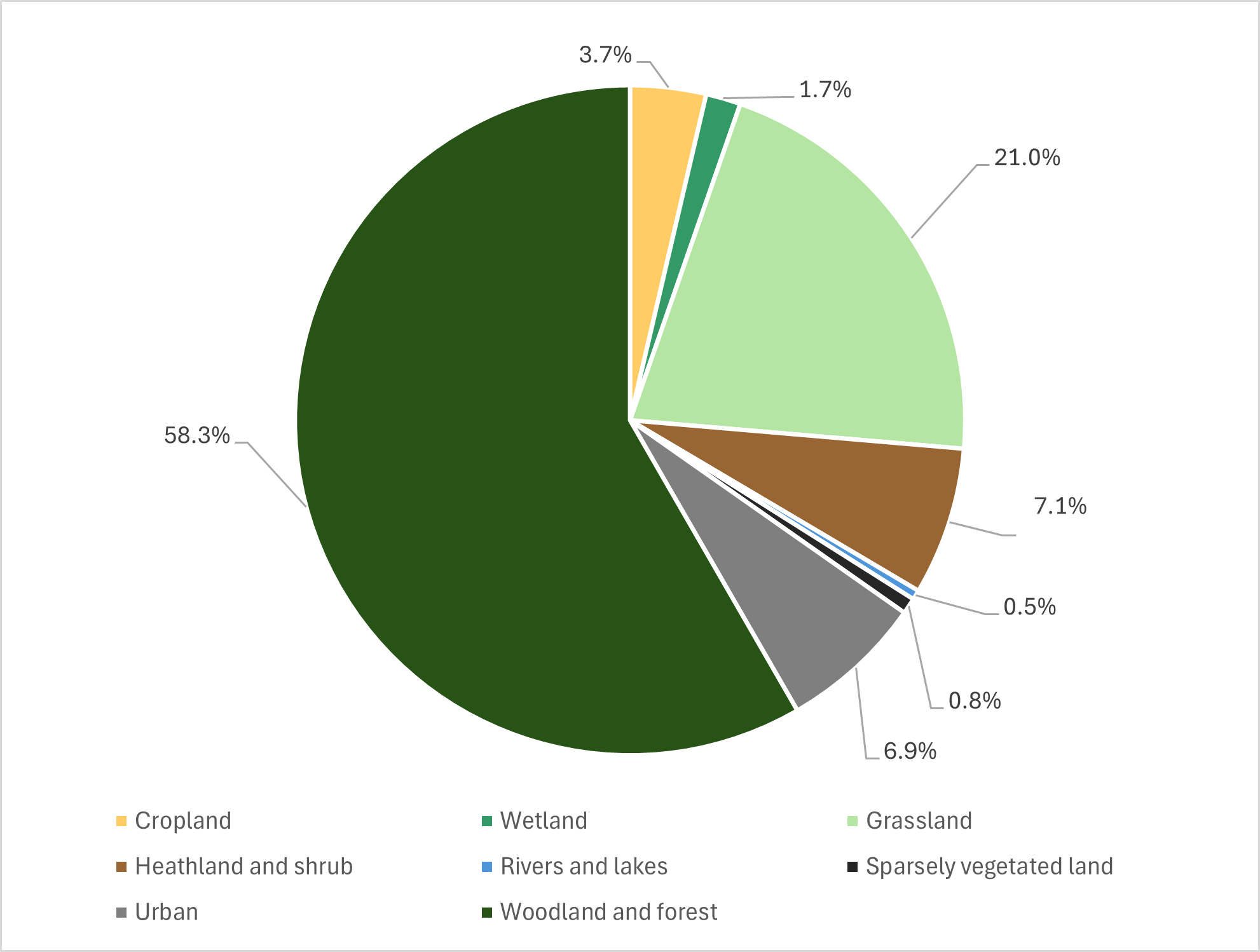
The main ecosystems recorded within the study area (including the ‘off-site’ mitigation areas at Muir of Thorn and Gelly Wood), as defined by UK Habitat Survey (UKHab) classification, are woodland and forest, grassland, urban, cropland, heathland and shrub, wetlands, rivers and lakes (see Aquatic Baseline Conditions paragraphs 12.3.20 to 12.3.23 for further detail), and sparsely vegetated land.
Habitat types, as defined by UKHab, within the study area are shown on Figure 12.3, with the proportion shown in Diagram 12.1. General descriptions for these habitats are provided in Appendix A12.3 (Detailed Survey Methods and Baseline Data).
Parcels of habitats that may contribute to foraging, nesting, breeding and/or commuting habitat for faunal species of conservation importance are included as part of the assessment for the relevant species.
Groundwater Dependent Terrestrial Ecosystems Baseline Conditions
Phase 1 habitat surveys undertaken in 2014 identified eight habitats potentially supported by groundwater (Transport Scotland, 2014c). However, subsequent surveys undertaken in 2015 considered that the assemblages of species and habitats observed did not constitute groundwater dependent terrestrial ecosystems (GWDTEs) as defined in Land Use Planning System Guidance Note 31 (SEPA, 2017) and no further surveys and/or analysis is required (Transport Scotland, 2021).
Further habitat surveys (and subsequent desk-based assessment and reviews) were undertaken in 2021, 2022, 2024 and 2025 to update Phase 1 habitat survey data and to collect baseline data for the ‘off-site’ mitigation areas at Muir of Thorn and Gelly Wood, specifically woodland planting and management. Areas of bog and bog woodland were recorded at the Muir of Thorn to the south of the scheme (see Figure 12.3) in 2025. These habitats have the potential to constitute GWDTE, however no further surveys have been undertaken as these areas will not be impacted by construction activities. Further details on these habitats are provided in Appendix A12.3 (Detailed Survey Methods and Baseline Data).
Aquatic Habitats Baseline Conditions
Rivers and lakes contribute to 0.5% of the habitats in the study area, as shown in Diagram 12.1. The River Tay is the main watercourse within the study area, running roughly parallel to the existing A9 for the length of the proposed scheme. Five named watercourses are crossed by the A9 in the study area: Inchewan Burn, Birnam Burn, River Braan, Mill Stream and the River Tay. There are 16 water features within the study area assessed as being minor watercourses, typically smaller unnamed streams as detailed in Chapter 19 (Road Drainage and the Water Environment). Of these, 12 are minor watercourses which are culverted under the existing A9.
Two Water Framework Directive (WFD) classified watercourses are present under the footprint of the proposed scheme: the River Tay (River Tummel to River Isla Confluences; ID: 6499) and River Braan (ID: 6576). The River Tay has obtained an overall classification of Poor Ecological Potential and a status of Bad for overall ecology in the 2020 round of classifications (the most recently published data). The watercourse also obtained a classification of High for all macroinvertebrate parameters, fish and fish barriers. The River Braan has been assigned Good overall status in 2020, with classifications of Good for fish and fish ecology, High for fish barrier, and a High classification for all macroinvertebrate parameters (SEPA, 2024b).
Suitable habitat to support Atlantic salmon, FWPM, lamprey species, brown/sea trout and European eel (Anguilla anguilla) was identified throughout the study area. High quality habitat for key life stages of several of these species of conservation interest was observed in reaches of the River Tay. The River Braan and Inchewan Burn contained mixed suitability habitat.
Outside the study area, the River Braan and Inchewan Burn contain in-stream structures that form barriers to upstream movement under certain flow conditions (Marine Scotland, 2020). An unnamed cascade is present approximately 200m upstream of the A9 crossing point on Inchewan Burn (at Ordnance Survey (OS) grid reference NO 02938 41570) and the Black Linn Waterfall (OS grid reference NO 00814 41760) is found 1.65km upstream of the A9 crossing point on the River Braan. The presence of these features has been considered within this assessment in the context of migratory fish and catchment connectivity.
Protected Species Baseline Conditions
Protected species known, or likely, to be present within the study area are detailed in Appendix A12.3 (Detailed Survey Methods and Baseline Data). A confidential appendix (Appendix A12.4: Confidential Biodiversity Resources) has been produced for badger, bat roosts, beaver, otter, Schedule 1 birds and FWPM as the precise locations of these species need to be kept confidential for their protection.
A summary of protected species baseline conditions is provided:
- badger – records from NBN and Scottish Badgers were received, and site surveys further confirmed the presence of badgers and their setts within the survey area;
- bats – seven species were identified within the study area including common pipistrelle (Pipistrellus pipistrellus), Nathusius' pipistrelle (Pipistrellus nathusii), soprano pipistrelle (Pipistrellus pygmaeus), brown long-eared bat (Plecotus auritus), Daubenton’s bat (Myotis daubentonii), Natterer’s bat (Myotis nattereri), and noctule (Nyctalus noctula). The site surveys identified trees, buildings and structures with the potential to support roosts. Site visits confirmed a large number of roosts present in the survey area;
- beaver – several records within the last ten years were identified and site surveys undertaken recorded beaver presence throughout the survey area;
- bird species – records from RSPB and BTO indicate a large number of birds in the area, and site surveys have recorded 64 species including several Schedule 1 species. Kingfisher (Alcedo atthis) have been recorded breeding within the survey area;
- otter – several records within the last ten years were identified and site surveys identified further holts and couches within the survey area;
- water vole – historical records of water vole were identified within the study area;
- pine marten – pine marten are known to be prevalent in the area. Site surveys had no sightings, however one potential den was recorded, and several potential field signs were incidentally recorded during habitat surveys at Gelly Wood and Muir of Thorn;
- wildcat - no priority areas for wildcat are located within the study area, however the desk-based assessment identified two records of wildcat within the study area, approximately 3-4km from the proposed scheme;
- red squirrel – several active dreys and individuals have been recorded within the survey area;
- reptiles – desk study records were scarce within 10km study area; however, reptile presence (slow-worm (Anguis fragilis), common lizard (Zootoca vivipara) and adder (Vipera berus)) was confirmed in several areas within the survey area, including incidentally during habitat surveys at Gelly Wood and Muir of Thorn;
- Atlantic salmon – known to be widespread along the River Tay and present within the River Braan. Suitable habitat has been recorded within the study area, but no evidence of spawning salmonids observed;
- lamprey (river/brook/sea) – have been recorded within the River Tay and site surveys confirmed suitable habitat present;
- brown trout/sea trout – there are historic records of these within the River Tay and suitable habitat present within the survey area;
- European eel – there are historic records of these within the River Tay and suitable habitat present within the survey area along with incidental sightings;
- FWPM – NatureScot indicated that FWPM are present within the River Tay and site surveys found populations of FWPM (juveniles and adults); and
- Terrestrial invertebrates – desk study records of five species of invertebrates listed on the SBL were available within the 10km study area.
Other Species of Interest Baseline Conditions
Deer
Four species of deer (roe (Capreolus capreolus), red (Cervus elaphus), fallow (Dama dama) and sika (Cervus nippon)) were identified within the 10km study area during the desk-based assessment. They are not legally protected for nature conservation reasons, but roe deer are listed on the Tayside LBAP protected species list (Tayside Biodiversity Partnership, 2016). Deer are of concern to the project due to deer vehicle collisions (DVC). DVCs have been recorded within the study area (Transport Scotland, 2015c). Deer species are not assessed as biodiversity resources in this assessment (see paragraph 12.2.45).
Invasive Non-Native Species
INNS present a threat to biodiversity (Department for Environment, Food & Rural Affairs, The Scottish Government, and Welsh Government, 2023).
Desk study data identified a number of INNS present within the study area, including rhododendron (Rhododendron ponticum), Himalayan balsam (Impatiens glandulifera), giant hogweed (Heracleum mantegazzianum) and Japanese knotweed (Reynoutria japonica) (Transport Scotland, 2015b; SEPA, 2024c).
INNS plants were recorded incidentally during species/habitat surveys. In addition to those species mentioned in paragraph 12.3.28, the following non-native species were also recorded: snowberry (Symphoricarpos sp.); dame’s violet (Hesperis matronalis); pink purslane (Claytonia sibirica); sweet cicely (Myrrhis odorata); yellow archangel (Lamium galeobdolon); and Welsh poppy (Papaver cambricum).
Grey squirrel was identified during the desk-based assessment to be abundant within the study area; with almost 1,000 recorded sightings within the last ten years throughout all woodland in the vicinity of the proposed scheme, and notably throughout both Dunkeld and Birnam urban areas. The proposed scheme is immediately north of the highland red squirrel protection line proposed by the Scottish Strategy for Red Squirrel Conservation (The Scottish Squirrel Group, 2015).
Future Baseline Conditions
The future baseline is a description of the likely evolution from the current state of biodiversity resources without implementation of the proposed scheme (Highways England et al., 2020a-b). The future baseline considers the following:
- natural changes to species or habitats; for example, changes to the distribution of protected species;
- impacts or effects of other known developments including any associated mitigation or enhancement measures assumed to be operational/implemented; and
- general trends affecting biodiversity; for example, climate change.
Species and Habitats
The distribution and abundance of species and habitats within the study area are likely to see changes as a result of climatic and anthropogenic factors.
Beaver have rapidly expanded throughout the Tay catchment (Campbell-Palmer et al., 2018) and their expansion is likely to continue. With a reduction in availability of suitable habitat due to increased intra-specific competition, beaver populations will continue to spread up the tributaries of the River Tay within the study area. Beaver are already beginning to populate tributaries such as the Inchewan Burn, the River Braan, and Mill Stream. Once all habitat is occupied the beaver population will plateau, reaching carrying capacity within the study area.
At least nine of the 17 bat species living and breeding in the UK are found in Scotland (Bat Conservation Trust, 2024). Some species have a restricted range in Scotland; for example Nathusius’ pipistrelle, noctule, Leisler’s bat (Nyctalus leisleri) and whiskered bat (Myotis mystacinus) are only known to breed in southern parts of Scotland (Bat Conservation Trust, 2024). However, as the climate changes, the breeding ranges of these species may change and there is the potential for these species to exploit suitable habitats within the Tay region in the future. Both Nathusius’ pipistrelle and noctule were recorded during the DMRB Stage 3 surveys (see Appendix A12.3: Detailed Survey Methods and Baseline Data).
Atlantic salmon are threatened by increases in water temperatures within both the marine and freshwater environment (Fisheries Management Scotland, 2024). As the climate changes, there is the potential for numbers of Atlantic salmon to decline. This has the potential to impact populations of FWPM within the Tay Catchment due to the dependency on salmonids to breed, as well as implications for predator species such as otter. FWPM are also vulnerable to climate change, as water temperature is an important factor in FWPM growth and survival at different life stages. Changes in seasonal water temperature has implications for FWPM at sensitive life stages which can impact FWPM populations, and increased water temperatures lead to a reduction in the availability of dissolved oxygen in the water which threatens this species (Skinner et al. 2003; Wacker et al., 2024; Wagner et al., 2024). As such the range of these species is likely to see changes over the long-term if climate change predictions manifest.
Land Management and Other Developments
The Perth and Kinross Local Development Plan 2 (Perth and Kinross Council, 2019) states that for Dunkeld and Birnam “the potential for additional development is highly constrained by potential flooding, the surrounding topography, and by various international and national natural and built heritage designations surround the towns”. Therefore, only small-scale infill residential development is proposed around the towns.
Consultation received from PKC regarding planning applications submitted up to June 2024 revealed proposed works mostly pertaining to extension of dwellings, erection/demolition of small-footprint buildings, formation of access tracks in an adjacent field and extension of a caravan park. These proposed developments will have minimal land take and, therefore, changes to the habitats and species in the study area will be limited. Details of proposed developments are described in Chapter 16 (Population - Land use).
Forestry plans (FLS, 2024; Scottish Woodlands, 2024) for crop harvesting and replanting with similar species will not affect the future baseline conditions as long-term there will be no change to the habitat type. Forestry plans (FLS, 2024; Scottish Woodlands, 2024) that alter the woodland species composition or canopy cover will potentially alter the future baseline within the study area. Several areas will be subjected to clear felling, with native seed trees left standing to aid natural regeneration under the current forestry plans. The habitat type and function of the woodland will be altered in the medium term, however in the long-term conditions would be reestablished to a similar baseline as is currently present. There is also the potential for benefits from such management activities to replace non-native species with native species.
Climate and General Trends
Chapter 19 (Road Drainage and the Water Environment) and Chapter 20 (Climate) describe in detail likely future scenarios in regard to the effects of the changing climate within the study area. Generally, it is projected that winters will be milder and substantially wetter, and summers will be hotter and substantially drier, with more extreme weather events. This will likely lead to greater flood events during winter months and potentially a greater risk of forest fires in summer.
In respect to biodiversity, these climatic changes will potentially lead to changes in habitat species composition through increasing the proportion of drought tolerant species and decreasing cold tolerant species. The changes may provide opportunities for new INNS to become established and new plant/animal diseases to take hold. Increased flood events may lead to increased wildlife vehicle incidents (WVIs) for riparian mammals such as otter and beaver attempting to cross carriageway where culverts are flooded. Drier summers will reduce the availability of small, ephemeral waterbodies for amphibians and insect species. Benefits to our native species may include increased survival rates for animals e.g. red squirrel, badger and bird species. Species operating at the edge of their range in Scotland or the UK may be able to move northwards; for example bat species, as discussed in 12.3.31, could move northwards into central and north of Scotland. These changes will be gradual in terms of a human lifetime but longer-term interactions with road infrastructure or surrounding habitat should be considered and mitigation amended if required to reflect the potential future baseline, as the baseline will see changes as a result of its vulnerabilities to climate change.
Evaluation of Baseline Conditions
The legal status and conservation status of biodiversity resources within the study area is provided in Appendix A12.1 (Legislation and Policy) and Appendix A12.3 (Detailed Methods and Baseline Data). The evaluations take into account baseline conditions and use the criteria in Tables 12.3 to 12.5 to develop an understanding of the implications for biodiversity resources that may be affected by the proposed scheme. Biodiversity resources are ordered by importance, with habitats followed by species.
The only records of wildcat were over 3km from the proposed scheme (see paragraph 12.3.25); no evidence was recorded within the study area. As shown in Figure 12.2 suitable habitat for wildcat surrounds the proposed scheme, therefore this species will be considered alongside other similar species in terms of habitat retention and potential for enhancement in relation to connectivity and mitigation measures. Those that will protect other biodiversity resources will also mitigate for any potential impacts on wildcat. Wildcat is therefore scoped out of ecological evaluation and impact assessment.
Deer and INNS (including grey squirrel (Sciurus carolinensis)) were scoped out from ecological evaluation; however, INNS (including grey squirrel) have been considered within the impact assessment (see Appendix A12.7: Impact Assessment Tables), as explained in paragraph 12.2.26-12.2.29.
Biodiversity resources were determined to be included or excluded from the assessment through evaluation of currently available desk-based and/or site survey data. Where these data indicate that a biodiversity resource is not known to be present within the study area, or no effects pathways have been identified, the biodiversity resource is determined to be unlikely to be affected by the proposed scheme and, therefore, is not taken forward for assessment. The following biodiversity resources will not be discussed further.
- The Forest of Clunie SPA: the HRA identified a potential effect pathway from disturbance to osprey breeding sites outwith the SPA; no effects pathways for the other qualifying interests were identified. Osprey were recorded in pairs within the study area (Appendix A12.4: Confidential Biodiversity Resources); however, no breeding sites for osprey were recorded. As no breeding sites will be impacted by the proposed scheme there are no impacts on the osprey population and, therefore, no impacts on the SPA are predicted.
- Craig Tronach SSSI: the SSSI is designated for forked spleenwort and is located 150m from the proposed scheme on the opposite side of the River Tay. Negative pressures on forked spleenwort are recreation/disturbance (NatureScot, 2024c). As the proposed scheme will not encroach into the SSSI, no impacts on the SSSI are predicted.
- Cairnleith Moss SSSI: the SSSI is located over 2.5km from the proposed scheme, adjacent to ‘off-site’ mitigation areas. No construction activities will be undertaken in these areas and as such no impacts on the SSSI are predicted.
- GWDTEs do not feature within the main extent of the proposed scheme or adjacent areas. Habitats with the potential to support GWDTEs are present within and adjacent to the ‘off-site’ mitigation areas at Muir of Thorn, however, no construction will be undertaken in these areas. No impacts on this biodiversity resource are predicted.
- Upland birchwoods and native pinewoods are identified as priority habitats in the Tayside LBAP and are present within 500m of the proposed scheme; however, these habitat types were not identified under the footprint of the proposed scheme. Therefore, these habitat types have not been considered further in this assessment.
- Blanket bog and wetland habitats are not recorded under the footprint of the scheme, or within the adjacent areas. The only areas of bog were recorded in the ‘off-site’ mitigation area at Muir of Thorn and Gelly Wood where these habitats are present adjacent to the Cairnleith Moss SSSI. These habitats will not be impacted by the proposed scheme and have not been considered further in this assessment.
- The Schedule 1 bird species barn owl is regionally important. Targeted surveys of potential nesting and roosting locations for this species did not find any evidence within the study area. One dead barn owl was recorded adjacent to the A9 at Muir of Thorn in 2025 during habitat surveys. A pellet was also identified within the woodland at Muir of Thorn, considered likely to be barn owl. Due to the lack of breeding evidence and the small amount of suitable habitat affected by the proposed scheme, effects have been scoped out as the scale of impact is unlikely to be significant.
- The Schedule 1 species, honey buzzard (Pernis apivorus), is nationally important. Vantage point surveys were undertaken for Schedule 1 species and honey buzzard was only recorded once during these surveys (detailed results see Appendix A12.4 (Confidential Biodiversity Resources). No other sightings or evidence was recorded during surveys and, therefore effects have been scoped out as the scale of impact is unlikely to be significant.
- A single historical record of water vole from 1960 was identified within a 10km radius of the study area. No other records of water vole were available (NBN, 2024). No evidence of water vole presence was identified during site surveys within the main extent of the proposed scheme. Small mammal holes were identified along a wet ditch within woodland at Muir of Thorn, however, no other signs were recorded to conclude evidence of water vole. The area at Muir of Thorn will not be impacted by construction of the proposed scheme. Therefore, water vole are not considered further in this assessment.
Table 12.6 shows a summary of the assessment of importance of each biodiversity resource based on legal designation, desk study records and site surveys. For a full evaluation see Annex 1 of Appendix A12.7 (Impact Assessment Tables).
|
Biodiversity Resource |
Commentary |
Importance |
|
Designated Sites |
||
|
River Tay SAC |
The River Tay SAC (including the River Tay (WF06) and the River Braan (WF11)) (UK0030312) is a European site designated under the Habitats Regulations 1994 (as amended). The site is selected for its clear-water lakes, and populations of Atlantic salmon, river lamprey, brook lamprey, sea lamprey and otter. The River Tay SAC is present along the extent of the proposed scheme (with the scheme footprint within or directly adjacent to the SAC at a number of locations) and is crossed by the A9 at the Tay Crossing and the mouth of the River Braan. The River Tay SAC is listed as a key site in the Tayside LBAP and the River Tay and River Braan are SEPA WFD watercourses. |
International |
|
Habitats |
||
|
Ancient woodland (including ancient and veteran trees) Woodland listed on the AWI - 1a and 2a, 1b and 2b, and 3. |
Ancient woodland is SBL priority habitat classed as an important and irreplaceable national resource that should be protected and enhanced. Ancient woodland, both semi-natural and plantation woodland of ancient origin are not readily replaceable if lost. These habitats have value for the species they support, and for habitat connectivity. There are some areas listed on the AWI where trees have been felled; however, these are considered to retain ancient woodland biodiversity value both now and in the future. Ancient and veteran trees are also important and considered an irreplaceable habitat. |
National |
|
Woodland and Forest (broadleaved and coniferous; non-AWI) (w1c6, w1d, w1d6, w1f7, w1g, w1f, w1h, w1h5, w1h6, w2b, w2c) |
A total of 13.76ha of broadleaved, coniferous and mixed non-AWI woodland habitats were recorded under the footprint of the proposed scheme. Lowland mixed deciduous woodland (w1f7) and planted coniferous woodlands (w2c) are listed as priority habitats on the Tayside LBAP. Woodland provides important habitat for a variety of species, including species afforded protection under international and national legislation. |
Regional |
|
Rivers and lakes (non-priority) (r2b) |
The main watercourse associated with the proposed scheme is the River Tay which is designated as an SAC and comprises a priority habitat (r2a). The River Braan falls partially within the SAC and is also classified as a priority habitat. These habitats are assessed under the River Tay SAC section. The other river and lake habitats present (r2b), including Inchewan Burn, Mill Stream (WF12) and unnamed or minor watercourses crossed by the scheme (Birnam Burn (WF01); WF02; WF05A; WF09; WF12A; WF12B; WF13; WF14; WF16 and WF18) enrich the resource in the authority area. |
Authority Area |
|
Heathland and shrub (h1a7, h1b6, h3e, h3h) |
Two key areas of scrub were found on the southbound banks of the A9 north of the Tay Crossing and an area of felled AWI woodland between the B867 and A9 south of Birnam. Scrub provides important habitat for a variety of protected species including reptiles and birds, including those listed as priority in the Tayside LBAP. |
Local |
|
Acid grassland (g1c, g1a6, g1d) |
Small areas of acid grassland, primarily bracken (g1c) are present within the study area adjacent to the proposed scheme. Most of these areas were adjacent to coniferous woodland or on clearfell sites. Acid grassland is also the dominant grassland habitat present at the offsite areas (Gelly Wood and Muir of Thorn). Bracken and other acid grassland sites provide suitable habitat for a range of species, offering food and cover for mammals, bird reptiles and invertebrates. |
Local |
|
Neutral grassland (g3c, g3c7, g3c5, g3c8) |
Neutral grassland (g3c, g3c5, g3c8) was the dominant grassland habitat type within the study area comprising approximately 21ha of the habitats within the proposed scheme boundary. Other neutral grassland (g3c) is a type that is typically widespread in the lowlands, around farmland and built-up areas. |
Local |
|
Cropland (c1b, c1c7, c1d8) |
Cropland accounts for approximately 6% of the total area surveyed. Cereal crops (c1c7) were recorded in a field to the east of Birnam and potato crop (c1d8) was recorded in a field south of the Tay Bridge. An area of temporary grass (c1b) comprising timothy crop was recorded adjacent to Inver Wood, south of the Tay Bridge. |
Less than local |
|
Sparsely vegetated land (s1d) |
Sparsely vegetated land was recorded within the inactive quarry in Inver Wood. This area was colonised by broom and ruderal species, with some larch (Larix decidua) and Douglas fir (Pseudotsuga menziesii) seedlings also present. |
Less than local |
|
Grassland (modified) (g4) |
Modified grassland (g4) was present within the study area, mostly as roadside verges and other improved grassland areas. This habitat type is associated primarily with urban habitats and is intensively managed. |
Less than local |
|
Urban (u1b5, u1b6, u1c, u1d, u1e) |
The majority of urban habitats recorded are associated with Birnam, Little Dunkeld and Inver and the existing road network, including the A9. |
Less than local |
|
Species |
||
|
Atlantic salmon |
Atlantic salmon is a qualifying feature of the River Tay SAC, listed on the SBL and as protected species in the Tayside LBAP. This species is widespread throughout the study area and there is evidence of suitable habitat to support all key life stages on the main stem of the River Tay and within major tributaries. This species is afforded protection under the Salmon and Freshwater Fisheries (Consolidation) (Scotland) Act 2003 and The Conservation of Salmon (Scotland) Regulations 2016. |
International |
|
River lamprey/brook lamprey/sea lamprey |
River, brook and sea lamprey are qualifying features of the River Tay SAC, listed on the SBL and as protected species in the Tayside LBAP. These species are widespread throughout the study area and there is evidence of suitable habitat to support all key life stages on the main stem of the River Tay and within major tributaries. These species are afforded protection under Salmon and Freshwater Fisheries (Consolidation) (Scotland) Act 2003. |
International |
|
Brown trout/sea trout |
Sea trout is listed on the SBL and brown trout are listed as protected species in the Tayside LBAP. Trout are afforded protection under the Salmon and Freshwater Fisheries (Consolidation) (Scotland) Act 2003. Suitable habitat is present throughout the River Tay catchment for trout. Brown/sea trout function as a host species for FWPM glochidia. |
National |
|
European eel |
Eel are afforded protection under European Commission (2007) Council Regulation (1100/2007/EC) and Salmon and Freshwater Fisheries (Consolidation) (Scotland) Act 2003. European eel are critically endangered on the IUCN red list and are listed on the SBL. Supporting habitat is present throughout much of the River Tay catchment. There are historical records of European eel within the River Tay. |
International |
|
FWPM |
FWPM is protected under Schedule 5 of the WCA 1981 (as amended) and is listed under Annex II of Council Directive 92/43/EEC, the SBL and on the Tayside LBAP. Both FWPM and their salmonid hosts are widespread throughout the study area. There is suitable FWPM supporting habitat throughout the River Tay catchment. |
International |
|
Otter |
Otter is a European protected species afforded protection under the Habitats Regulations 1994 (as amended). This species is listed on the UK Biodiversity Action Plan (UKBAP), SBL and Tayside LBAP. Otter is widespread throughout Scotland and has reached carrying capacity in the catchment which the proposed scheme passes through. It is a qualifying feature of the River Tay SAC. |
International |
|
Beaver |
Beaver is a European protected species and is afforded protection under The Habitats Regulations 1994 (as amended in Scotland). It is also listed as Endangered in Scotland in the IUCN Red List for Britain’s Terrestrial Mammals. The population in Tayside is the largest in Scotland, with 73 territories recorded along the River Tay during the 2017-2018 NatureScot Survey of the Tayside area beaver population (Campbell-Palmer et al., 2018). There is suitable habitat within the proposed scheme footprint with at least two separate territories. |
National |
|
Badger |
Badger is afforded protection under the Protection of Badgers Act 1992 and is listed as a protected species in the Tayside LBAP. A total of one main (partially used), one main (disused), one main (used), three subsidiary setts (disused) and eight outliers (disused) were recorded within 500m of the proposed scheme. Full survey results are provided in Table A12.4.1 in Appendix A12.4 (Confidential Biodiversity Resources). |
Regional |
|
Breeding birds (excluding Schedule 1 species) |
Breeding birds are afforded protection under the WCA 1981 (as amended). Eight of the 17 breeding species were listed as species of conservation concern, either red-listed or amber-listed, and five are listed on the SBL and six are listed as protected species on the Tayside LBAP. Species that are listed as being of conservation concern in the UK (red- or amber-listed) or are of importance for the conservation of biodiversity in Scotland (SBL-listed), or for which the area of the proposed scheme is considered to contribute towards supporting their populations at a regional level, through providing foraging and nesting sites. Remaining species are considered to enrich the local breeding bird community. |
Regional |
|
Breeding birds - Schedule 1 species |
The study area supports breeding Schedule 1 species, afforded additional protection under the WCA 1981 (as amended). Schedule 1 birds including peregrine (Falco peregrinus), goshawk (Accipiter gentilis), kingfisher, osprey and crossbill have been recorded during surveys. Habitats within the study area provide nesting and/or foraging habitat for these species. |
Regional |
|
Bats |
Bats are European protected species and are afforded protection under the Habitats Regulations 1994 (as amended). With the exception of Leisler’s bat, all bat species in Scotland are listed on the UKBAP and SBL. Seven of Scotland’s nine bat species were recorded within the study area. Fifty-four confirmed roosts were identified within 50m of the proposed scheme and there are areas of habitat within the study area which have been confirmed to support a moderate to high activity level of bat passes (foraging and commuting). |
Regional |
|
Red squirrel |
Red squirrel is afforded protection under Schedule 5 of the WCA 1981 (as amended) and is listed on the UKBAP, SBL and Tayside LBAP. This species is widespread throughout Scotland despite declines in populations and range. The proposed scheme is immediately north of the Scottish Strategy for Red Squirrel Conservation (The Scottish Squirrel Group, 2015) proposed highland red squirrel protection line. Abundant foraging and breeding opportunities exist within the study area. |
Regional |
|
Pine marten |
Pine marten is afforded protection under Schedule 5 of the WCA 1981 (as amended) and is listed on the UKBAP, SBL and Tayside LBAP. This species continues to expand its range throughout Perthshire and Tayside, since being confirmed to have re-colonised the area in the 1990s (Balharry et al., 1996; Croose et al., 2013). |
Regional |
|
Reptiles: adder, slow worm and common lizard |
Adder, slow worm and common lizard are afforded protection under Schedule 5 of the WCA 1981 (as amended) and are listed on the UKBAP and SBL. These species exhibit a decreasing population trend and are listed as being of conservation importance within the Tayside LBAP (Tayside Biodiversity Partnership, 2016). McInerny and Minting (2016) state that Scotland is host to an important population of adder in comparison to the declining population in the rest of the UK. |
Regional |
|
Terrestrial invertebrates |
Five species of invertebrate listed on the SBL were recorded within the study area. Habitats within the study area provide suitable habitat for all life stages for a range of invertebrates. |
Local |
Potential Impacts and Effects
Introduction
This section sets out the types of construction and operational impacts on ecological features which may result from the proposed scheme.
General potential impacts on biodiversity resources for the proposed scheme are described in subsequent paragraphs and specific potential impacts on biodiversity resources are set out in Table 12.9 and Table 12.10 (Section 12.6: Residual Effects). Many potential impacts on biodiversity resources associated with road operations, are already experienced by the species and habitats in the vicinity of the existing A9.
Where a potential impact is assessed as not significant, it is not considered further. Standard design and construction best practices will be in place to mitigate non-significant impacts.
Where a potential impact is initiated in construction but could also occur throughout operation (e.g. permanent habitat removal), it is discussed only within operational impacts.
Chapter 8 (Air Quality) discusses potential air quality impacts on the River Tay, ancient woodland and veteran trees in the study area. The River Tay SAC and woodland habitats have known sensitivities to pollution, including dust and nitrogen deposition. The potential for impacts on important ecological features is also considered in this chapter and Appendix A12.5 (Ecology Air Quality Assessment).
During an ESG meeting in July 2015, SNH (now NatureScot) highlighted concerns on the impacts of road salt on the water environment. The salt assessment detailed in Appendix A19.6 (SuDS and Water Quality) indicates that salt levels are not expected to exceed the Canadian short-term exposure guideline (there is currently no UK guideline) within the River Tay SAC. The short-term exposure guideline may be exceeded in two water features, WF05A and WF12, however these water features contain only poor-quality aquatic habitat and salt concentrations would be diluted below the guidelines within the River Tay SAC due to the large volume of water at mean flow rate for this watercourse. Therefore, the impacts of salt on the water environment are not considered further. Further details are provided in Appendix A19.6.
Potential impacts detailed in this assessment are based on the current baseline. Due to the mobile nature of animals and changes in distribution of plant species, surveys to update the baseline will be undertaken prior to construction.
Construction Impacts
Effects on biodiversity resources during construction of the proposed scheme have been identified taking account of the indicative construction methods and timelines (Chapter 6: The Proposed Scheme).
Potential construction impacts and effects may include:
- injury or mortality of species due to vegetation removal, in-stream works, vehicle movements, and from becoming trapped in uncovered holes and pipes;
- disturbance of species from noise, vibration, lighting and increased human activity;
- temporary habitat loss and/or fragmentation due to disturbance activities or temporary removal of habitat for non-permanent aspects of the proposed scheme, including haul routes, working areas and site compounds;
- spread of INNS due to movement of plant and soils;
- temporary loss of habitat resulting from construction works adjacent to and within the River Tay SAC;
- air quality impacts due to dust and nitrogen deposition; and
- changes in ecosystem health and quality resulting from the release of construction related pollutants, including sedimentation, and run-off; which could have implications for the quality and quantity of foraging available.
Operational impacts
Effects on biodiversity resources during the operational phase of the proposed scheme have been identified taking into account traffic use and the permanent footprint of the proposed scheme and permanent land use changes associated with the built road network.
Potential operational impacts associated with the proposed scheme include:
- injury and mortality of species from vehicle collisions;
- loss of species due to permanent land take;
- permanent loss of habitats, including rare and ecologically sensitive habitats for example ancient woodland;
- permanent loss and/or shading of aquatic habitats under the footprint of the proposed scheme;
- enlargement of barriers to the movement of biodiversity resources, as a result of increased built infrastructure footprint;
- continued effects relating to habitat loss and fragmentation/severance of habitats;
- air quality impacts due to nitrogen deposition (further details is provided in the Chapter 8: Air Quality);
- hydrology and hydrogeology impacts due to changes in the quality and flows of surface and ground water.
Throughout the operational phase of the proposed scheme there will be maintenance operations within the highways boundary which could result in impacts on biodiversity resources. These operations could result in changes in air quality, water quality and disturbance to ecological features through noise, vibration and lighting. Maintenance schemes throughout the lifetime of the proposed scheme will be required to adhere to wildlife and conservation legislation and employ best practice mitigation following up-to-date guidance. Therefore, specific impacts related to future maintenance operations have not been considered separately within this assessment but are instead addressed more generally under the operational impacts listed.
Cumulative Assessment
The potential for the proposed scheme to have cumulative effects on biodiversity in combination with other projects or plans is summarised in subsequent paragraphs. The HRA provides more detail in relation to the River Tay SAC qualifying interests (Transport Scotland, 2025).
The assessment of potential cumulative effects considers the following effects which are considered relevant to the proposed scheme:
- the additive effect of habitat loss (terrestrial and riparian);
- disturbance of fauna (due to construction phases overlapping or coinciding);
- impediments to passage of fish, otter and bats along the river corridors;
- sediment inputs or pollution incidents into watercourses; and
- reduction in air quality.
As discussed in Chapter 21 (Assessment of Cumulative Effects), developments within a 500m boundary of the proposed scheme have been reviewed, along with any large-scale developments beyond the 500m study area that are considered relevant due to their scale, location or timing.
Most of the developments are small-scale such as extension of dwellings, erection/demolition of small-footprint buildings. These proposed developments will have minimal land take and, therefore, changes to the habitats and species in the study area will be limited.
The other projects of the A9 Dualling Programme have the potential for cumulative effects with the proposed scheme. There is the potential that the construction phases will be concurrent, or consecutive. As such there is the potential for cumulative effects with the proposed scheme on biodiversity resources.
Further details on these developments are provided in Chapter 21: Assessment of Cumulative Effects.
Mitigation
Introduction
Mitigation will follow a hierarchical approach in the following order (Highways England et al., 2020a; CIEEM, 2018; SNH, 2018):
- avoid or prevent adverse impacts in the first instance;
- where avoidance is not possible, reduce the adverse impacts and effects through mitigation;
- where residual significant effects remain, compensation measures to offset the adverse effects at a site-specific level may be required; and
- enhancement should be sought to provide positive effects for biodiversity resources above avoidance, mitigation and compensation.
The DMRB Stage 3 process has focussed on providing detailed ecological input to the design process to avoid and mitigate significant environmental effects as far as possible. The embedded mitigation is designed to enhance and produce positive effects for biodiversity in line with policy and guidelines (Scottish Government, 2023, Scottish Government, 2024; Highways England et al., 2020a-b; CIEEM, 2018).
It is expected that the majority of non-significant impacts will be mitigated through the application of standard mitigation commitments and best working practice (e.g. mitigation of potential pollution impacts through adherence to standard best practice and guidelines, such as SEPA Guidance for Pollution Prevention (GPP) (SEPA, 2017) and Pollution Prevention Guidelines (PPGs) (NetRegs, 2024)).
Potential significant effects on biodiversity resources, as shown in Appendix A12.7: Impact Assessment, are expected to be mitigated through a combination of best practice mitigation methods and mitigation targeted to specific locations/species.
This section refers to overarching standard mitigation commitments applicable across all A9 dualling projects (‘SMC’ Mitigation Item references), and also to project-specific measures (‘P02’ Mitigation Item references). Those that specifically relate to Biodiversity are assigned an ‘E’ reference (to maintain continuity with previously published A9 Dualling Programme Environmental Statements).
Embedded Mitigation
Embedded mitigation has been developed through an iterative process using results from ecological surveys which identified a range of important habitats and protected species and consultation with NatureScot, SEPA and other relevant stakeholders.
The following embedded mitigation measures have been adopted and further information is provided in Chapter 5 (Iterative Design Development):
- Avoid and reduce the loss of habitat, including the focus on avoiding woodland (AWI and non-AWI) loss, where practicable through a sensitive and considered design approach.
- Avoid encroachment into designated and high value sites/areas, particularly the River Tay SAC.
- Incorporating species-rich grassland into final landscape design for example around Sustainable Drainage Systems (SuDS), and within verges and central reserves where practicable, to provide biodiversity benefits (see paragraph 12.5.14 and Chapter 10: Landscape). Targeted habitat creation surrounding the detention basins has been designed to provide biodiversity benefits for multiple species such as bats, reptiles and invertebrates. The proposed SuDS and proprietary drainage systems are described further in Chapter 19 (Road Drainage and the Water Environment) and Appendix A19.6 (SuDS and Water Quality).
- Planting will comprise native species in keeping with the surrounding environment.
- Designing culverts and underpasses to facilitate a permeable final development allowing safe animal passage under the proposed scheme.
- Ensuring that measures are developed to reduce the risk of introducing or allowing the spread of INNS during construction and that mitigation controls are detailed in the project Construction Environmental Management Plan (CEMP), and to plan construction works to ensure that INNS which have been identified on site are eradicated and controlled to avoid spread to the wider area.
- Two levels of treatment for road surface runoff from the main carriageway will be implemented using a combination of filter drains, ponds, basins and swales, to avoid impacts to the aquatic environment.
In addition, the iterative design process sought to avoid and reduce the loss of protected species resting sites where practicable through a sensitive and considered design approach, based on up-to-date baseline data.
Furthermore, part of the planting design the woodland planting will aim to comprise a maximum of 10% of large-seeded broadleaved trees to reduce the impact on the local red squirrel population. Having a high proportion of large-seeding broadleaved tree species in a woodland favours grey squirrels over red squirrels (Bryce et al., 2005).
Table 12.7: Standard mitigation measures (S = general, E = biodiversity specific)
SMC-S1
A Construction Environmental Management Plan (CEMP) will be prepared by the Contractor. The CEMP will set out how the Contractor intends to operate the construction site, including construction-related mitigation measures identified in Tables 21.2 to 21.11 (Chapter 22: Schedule of Environmental Commitments). The relevant section(s) of the CEMP will be in place prior to the start of construction work.
The CEMP will include, but not be limited to, subsidiary plans relating to: agricultural land (including a specific Soil Management Plan), geology and land contamination; surface water and groundwater (including a Flood Response and Pollution Incident Response Plan); ecology (Ecological Management Plan which will include specific Species Management Plans (SMP) and Habitat Management Plans (HMPs)); landscape, cultural heritage, air quality, biosecurity and noise and vibration.
SMC-E1
Pre-construction surveys will be undertaken to verify and, where required, update the baseline ecological conditions set out in the EIAR. The scope of the pre-construction surveys will be confirmed with NatureScot and Transport Scotland prior to them being undertaken.
SMC-E2
Prior to construction, a suitably qualified (or team of suitably qualified) Ecological Clerk of Works (ECoW) will be appointed and will be responsible for implementation of the Ecological Management Plan. The ECoW will:
- provide ecological advice over the entire construction programme;
- undertake or oversee pre-construction surveys for protected species in the areas affected by the proposed scheme; and ensure mitigation measures are implemented to avoid and reduce impacts on ecological features; and
- monitor the implementation of the mitigation measures during the construction phase to ensure compliance with protected species legislation and commitments within the EIAR and HRA.
The ECoW will be a member of the Chartered Institute of Ecology and Environmental Management (CIEEM) and will have previous experience in similar ECoW roles. All ECoWs will be approved by Transport Scotland to be appropriately qualified for the role and compliance will be monitored by the employer’s ecologist. The ECoW will be appointed in advance of the main construction programme commencing to ensure pre-construction surveys are undertaken and any advance mitigation measures required are implemented.
SMC-E3
Noise and vibration will be minimised by working within a dry area or working back from the riverbank where possible, to avoid disturbance, hearing damage or behaviour changes to fish. In addition, soft-start techniques will be applied to piling work procedures to enable mobile sensitive receptors to evacuate the area.
SMC-E4
Where areas are required to be temporarily dewatered to permit construction activities, fish will be removed by experienced and qualified personnel by means of electrofishing and relocated prior to dewatering.
SMC-E5
Water flow/passage will be maintained during any construction works within the watercourses to permit the movement of all fish species past areas of dewatering and/changing hydrology during any in-stream construction works. Suitable temporary channels may be implemented to maintain habitat connectivity. Where any over pumping is required, screens will be used to prevent fish from entering pumps.
SMC-E6
The Contractor will obtain and comply with the requirements of any protected species derogation licences in respect of works that have the potential to breach all applicable conservation legislation. Licensing may be for UK and/or European protected species.
SMC-E7
Tree felling and vegetation clearance to be minimised as far as practicable and undertaken outside the core bird nesting season (1 March to 31 August) to avoid damage or destruction of occupied nests or harm to breeding birds. If this cannot be achieved, works within the core bird nesting season will require an inspection of vegetation to be cleared for nesting birds by a suitably qualified ecologist no more than 24 hours prior to any works being undertaken. If any nesting birds are identified during the survey, they will be left in situ for their entire nesting period until the young birds have fledged. Alternative approaches to the work will need to be proposed e.g. leaving an exclusion zone around the nest to avoid disturbance.
All cleared vegetation will be rendered unsuitable for nesting birds, for example, by covering or chipping depending on the end purpose of the vegetation or will be removed from the works area.
SMC-E8
Any tree felling will be carried out by experienced contractors to reduce direct mortality of protected species according to agreed felling methods between contractors and the ECoW.
SMC-E9
Plant and personnel will be constrained to a prescribed working corridor through the use of, where practicable, temporary barriers to minimise the damage to habitats and potential direct mortality and disturbance to animals located within and adjacent to the proposed scheme working corridor.
SMC-E10
A construction lighting plan and method statement will be developed by the Contractor. The plan, which will form part of the CEMP (Mitigation Item SMC-S1), will be referred to in the SMPs. The SMPs will detail the specific mitigation requirements relating to protected species and habitats from the plan, which will take into account guidance on lighting (e.g. Institution of Lighting Professionals (2018, 2020), Bat Conservation Trust and Institution of Lighting Professionals (2023) and The Royal Commission on Environmental Pollution (2009)). The construction lighting design will take into account the need to avoid illuminating sensitive fish and mammal (e.g. for bats, otter and badger) habitats in locations such as: adjacent to watercourses; along woodland edges; and, where there is known activity identified through pre-construction ecological surveys (refer to Mitigation Item SMC-E1). Where this is not possible, the Contractor will agree any exceptions with NatureScot.
SMC-E11
During construction, trees will be protected in line with guidelines provided in ‘BS 5837 Trees in relation to Construction’ (British Standards Institute, 2012). This includes the following:
- establishment of Root Protection Areas (RPA);
- protective fencing will be erected around the RPA to reduce risks associated with vehicles trafficking over root systems or beneath canopies;
- selective removal of lower branches of trees to reduce risk of damage by construction plant and vehicles;
- prevent soil compaction measures; and
- maintain vegetation buffer strips (where practicable).
SMC-E12
Planting will be undertaken to replace any trees that were intended to be retained which are felled or die as a result of construction works. The size, species and location of replacement trees will be approved by Transport Scotland and other relevant stakeholders.
SMC-E13
Trenches, holes and pits will be kept covered at night or provide a means of escape for mammals that may become entrapped. Gates to compound areas will be designed sensitively to prevent mammals from gaining access and will be closed at night.
SMC-E14
Temporary mammal-resistant fencing will be provided around construction compounds where protected mammal species are known to be present; fencing will follow a specification agreed through consultation with Transport Scotland.
SMC-E15
The Contractor will describe within the CEMP (Mitigation Item SMC-S1) the biosecurity strategy to be implemented for the appropriate treatment of INNS.
The strategy will set out appropriate construction, handling, treatment and disposal procedures to prevent the spread of INNS in line with recognised best practice.
n/a (note)
In addition, the following standard mitigation commitments detailed in Chapter 19: Road Drainage and the Water Environment (W), Chapter 10: Landscape (LV), Chapter 8: Air Quality (AQ) and Chapter 15: Noise and Vibration (NV) will be implemented to protect aquatic and terrestrial habitats and species: SMC-W1, SMC-W2, SMC-W3, SMC-W4, SMC-W7, SMC-W13, SMC-W14, SMC-W15, SMC-W17, SMC-LV4, SMC-LV5, SMC-AQ1, SMC-AQ2 and SMC-NV2.
Specific Mitigation
Specific measures will be implemented to mitigate for impacts on biodiversity resources (during construction and operation of the proposed scheme) where embedded mitigation does not avoid or adequately mitigate an impact. Where mitigation measures are not relevant to the full length of the proposed scheme, their location has been described with chainages.
Designated Sites
Mitigation for impacts on qualifying interests of the River Tay SAC (otter, Atlantic salmon, and lamprey species) are discussed under relevant species sub-sections. Further detail on impacts and mitigation for the River Tay SAC is provided in the HRA (Transport Scotland, 2025).
Mitigation for temporary loss of habitat (aquatic and terrestrial) within the SAC will be delivered through adherence of Mitigation Items SMC-W1, SMC-W3, SMC-W4 and SMC-LV1, and specifically the following measures (Mitigation ItemP02-E16):
- terrestrial SAC areas temporarily required for construction will be returned to their former habitat type using species appropriate to the local environment and of local provenance;
- seeding and planting of bare ground areas within the SAC will be undertaken as soon as possible after the completion of construction works;
- appropriate measures, such as the use of geo-textile matting, will be put into place should vegetation establishment be delayed, preventing erosion of terrestrial SAC habitats and sediment entering nearby watercourses; and
- natural bed material within river will be retained and replaced on completion of construction works.
Habitats
Many of the general mitigation measures outlined in Table 12.7 (and in Appendix A12.7: Impact Assessment Tables) will serve to protect habitats, for example the CEMP, HMPs, use of temporary barriers and pollution prevention measures.
The areas around SuDS, and within verges/central reserves where practicable, will be seeded with a species-rich mix of native grasses and wildflowers, as appropriate, to provide additional biodiversity benefits. The margins of SuDS ponds/basins and swales will be planted with native emergent and marginal plant species, and the species-rich grassland mixes will consist of native, non-invasive grasses and wildflower species, to enhance biodiversity, for example by planting species that are favoured by invertebrates as food (Mitigation Item P02-E17).
Areas of non-significant habitat loss, which are important in supporting protected species, including those listed on the Tayside LBAP, are considered to be mitigated through the overall landscape and ecological planting design. This includes areas of woodland, scrub, and grassland of various types as shown on Figure 10.6.
Ancient Woodland
Avoiding and reducing woodland loss has been a key consideration during the design process, as explained in Chapter 4 (Iterative Design Development). Where avoidance of habitat loss (including AWI, woodland and important habitats for protected species) has not been achieved through the iterative design process, mechanisms for landscape scale mitigation or compensation have been designed to replace habitat that will be lost.
Sites for compensatory woodland planting (Mitigation Item P02-E18) have been identified to maximise the biodiversity benefit of the planting, maintain connectivity or reconnect existing AWI sites, and to maximise opportunities to maintain functionality of local ancient woodland communities throughout the route corridor. These sites include the ‘off-site’ mitigation areas at Muir of Thorn and Gelly Wood.
An AWI-specific HMP provided as part of the CEMP (Mitigation Item SMC-S1) will be prepared and implemented prior to construction. This will include details of retrieval of soils from AWI sites and how and where they will be re-used.
See Appendix A12.6 (Woodland Strategy) for full details on the approach to ancient woodland compensation.
Woodland (excluding Ancient Woodland)
Woodland lost to the scheme construction will be replaced through landscape and ecological planting, additional to compensation planting for ancient woodland loss, as shown on Figure 10.6.
See Appendix A12.6 (Woodland Strategy) for full details on the approach to woodland compensation.
Grassland
Any grassland habitat lost will be mitigated for through landscape and ecological planting, as shown on Figure 10.6.
Species
As stated in paragraph 12.5.7, the avoidance of protected species’ resting sites is embedded in the mitigation approach for the proposed scheme, and the design has taken baseline survey data into consideration to avoid impacts where possible. However, for some locations and species, disturbance and/or destruction of rest sites will be unavoidable.
Certain activities during construction will trigger the need for a protected species derogation licence under relevant legislation. Structures or places that protected species use for shelter that are located under the footprint of the proposed scheme will require to be destroyed under licence following consultation with NatureScot. A derogation licence may be required for any works taking place within a specified distance of a known protected feature for protected species. Indicative protection zones for each species are detailed in Table 12.8 in line with best practice guidance and professional judgement. The need for a derogation licence for work taking place within this distance will be assessed by an ecologist.
| Species | Indicative Non-breeding Protection Zone | Indicative Breeding Location Protection Zone | Indicative Protection Zone for Specific Activities (Piling/Blasting) |
|---|---|---|---|
| Otter | 30m | 200m | 100m (non-breeding) or 200m (breeding) |
| Badger | 30m | 30m | 100m |
| Bats | 30m | 30m | 100m |
| Pine marten | 30m | 100m | 100m |
| Red squirrel | 5m | 50m | 100m |
| Beaver | 20m | 50m | 100m |
| Wildcat | 200m | 200m | 200m |
Based on the current baseline, which will be updated following pre-construction surveys (Mitigation Item SMC-E1), derogation licences will be required for otter (disturbance), badger (disturbance and destruction), bats (disturbance and destruction), and beaver (disturbance). Additionally, licences for FWPM may be required following consultation with NatureScot.
Further details and mitigation for protected species is provided in the following sections.
Bats
Impacts on bats will be avoided or mitigated through the application of the general mitigation measures including but not limited to: minimising habitat loss, timing of works, sensitive lighting design, and woodland/hedgerow planting. These measures will be informed by pre-construction surveys, documented in a SMP for bats and implemented by the ECoW(s) and contractor.
The following specific mitigation measures will be implemented:
- No works will be undertaken without a licence in place from NatureScot if they will destroy a roost or cause temporary or permanent exclusion of bats from a roost, or if there is likely to be disturbance which could cause a bat to abandon a roost either temporarily or permanently. A destruction and/or a disturbance licence for works affecting confirmed roosts will be required prior to commencement (Mitigation Item P02-E19).
- A bat licenced ecologist will supervise any works for which a development licence for bats is required in accordance with the conditions of the development licence. All works and mitigation, including the exclusion of bats from confirmed bat roosts, will be undertaken in accordance with the development licence as agreed with NatureScot. It is anticipated such development licences will only allow exclusions to be fitted between April and October and be in place for a minimum of 14 days prior to demolition; once the 14-day period has finished, the roosts will be permanently blocked and/or destroyed (Mitigation Item SMC-E1; Mitigation Item P02-E20).
- It is anticipated development licences for buildings, structures and trees containing confirmed bat roosts will require to follow sensitive demolition/felling methods agreed in advance with NatureScot. Where an ECoW or bat licenced ecologist determines there is a sufficient risk of bats being present, despite no roost being confirmed during surveys, sensitive demolition by hand/ felling techniques under the supervision of a bat licenced ecologist will be undertaken until such time that the bat licenced ecologist is fully satisfied that no bats remain within the building, structure or tree and all reasonable precautions have been taken to avoid harming bats (Mitigation Item P02-E21).
- The loss of suitable roosting locations in trees, buildings and structures under the proposed scheme will be mitigated through the provision of suitable alternative roosting habitat, such as bat boxes or tree veteranisation and the installation of a dedicated bat roost structure as follows (Mitigation Item P02-E22):
- Three bat boxes, or suitable roosting features, to be installed for every PRF-M tree lost.
- Three bat boxes, or suitable roosting features, to be installed for every building and structure lost with bat potential.
- Bat boxes, or suitable roosting features, will be installed in each of five areas identified as being suitable locations for replacement roost habitat; the proportion of features installed in each of the five areas would take into account the size of the replacement roost habitat areas, along with the proximity to confirmed roosts or potential roost features being lost.
- A dedicated roost compensation structure (such as a timber pole with 1FS Schwegler bat boxes, or similar, mounted on it suitable for a large number of bats) will be installed in/near the woodland to the south of Inver and the River Braan. This will provide alternative roosting locations for the summer soprano pipistrelle roosts to be destroyed at BB 2.42a, BB 2.42b and BB 2.42d. This will also provide possible satellite roost opportunities for the large maternity roost at BB 2.81c.
- All replacement bat roost habitat will be installed prior to roosts or potential roost features in trees, buildings and structures being removed or destroyed.
- A SMP (see Mitigation Item SMC-S1) for bats detailing mitigation measures will be developed to account for roost types (i.e. summer roost, maternity, night roost, and hibernation roost) to minimise disturbance during critical periods. Mitigation may include noise and visual/lighting barriers as a minimum to reduce disturbance to acceptable levels.
- Where high noise generating activity, such as piling, must take place within 100m of known maternity and hibernation roosts this must be done outside sensitive periods. For maternity roosts this would avoid the maternity season (May to August) and for hibernation roosts this would avoid the peak hibernation period (December to February) (Mitigation Item P02-E23). Where these sensitive periods cannot be avoided, consultation with NatureScot will be undertaken and methods agreed through licensing where required.
- Retention of bat commuting routes through provision of culverts, underpasses and underbridges, and through retention of key linear woodland features, such that movement between areas of habitat is maintained (Mitigation Item P02-E24).
- Culverts, underpasses and overbridges suitable for multiple species, including bats, will be provided to mitigate fragmentation of habitat and to increase the permeability of the proposed scheme (Mitigation Item P02-E25).
- Additional planting around SuDS ponds will be provided to increase habitat suitability for foraging bats. Planting will include native species mixes suitable for the surrounding landscape. There will also be additional planting in areas throughout the proposed scheme to mitigate for the loss of commuting and foraging habitat as a result of the vegetation removal required for construction of the proposed scheme (Mitigation Item P02-E26).
- A construction lighting plan and method statement will be developed, informed by Guidance Note 8 Bats and Artificial Lighting (Bat Conservation Trust and Institute of Lighting Professionals, 2023) (Mitigation Item SMC-E10). The plan will aim to minimise the need for lighting at important crossing points (River Braan, Inchewan Burn, Mill Stream, and River Tay Crossing) and commuting routes during the construction phase (e.g. by limiting working during hours of darkness at these locations). The lighting design will also minimise light spill onto commuting routes, crossing points and roosting locations during the operational phase.
Badger
Impacts on badgers will be avoided or mitigated by several of the general mitigation measures, including, but not limited to, pre-construction surveys to identify active setts to be protected, lighting design, mammal resistant fencing, and a SMP for badgers. New woodland planting (see Chapter 10 (Landscape) and Figure 10.6) will also benefit badgers by providing new breeding, foraging and commuting habitat.
The following specific mitigation will be implemented (Mitigation Item P02-E27):
- Works which will cause damage or disturbance to badger setts (e.g., very heavy or noisy machinery working within 30m of sett entrances) or disturbance from other works (such as piling out to 100m) will not be undertaken without a development licence from NatureScot. Disturbance distances vary by the type of activity and local setting and would be confirmed by the ECoW. Where there is potential for disturbance, a precautionary approach will be taken and a licence obtained (Mitigation Items SMC-E6).
- No main setts fall under the footprint of the proposed scheme based on survey data collected to inform the assessment (see Appendix A12.4: Confidential Biodiversity Resources). However, if, following pre-construction surveys, a main sett or other significant sett likely to be used for breeding is found under the footprint of the proposed scheme, or which due to the nature of works will be at risk from partial destruction or significant disturbance, a licence for destruction or temporary closure will require to be obtained. Detailed bait marking surveys would be undertaken where necessary to inform the territory of the main/breeding sett. Where necessary, and when agreed through consultation with NatureScot, an artificial replacement sett would be installed at least six months prior to closure of a main sett. Closure of any badger sett would only be undertaken following a minimum of three weeks of monitoring to determine use by badgers. Where setts are found to be in use, a licence will be obtained from NatureScot. Closure would only be undertaken between late-June to late-November inclusive.
- Light will be angled away from all active setts and areas of significant badger activity and directional and/or cowled lighting will be used to prevent light-spill. A 30m protection zone will be maintained around all active setts, where practicable.
- Dry mammal underpasses, culverts (with ledges if required) and overbridges, which provide suitable passage for mammals, including badger, will be provided to increase permeability of the proposed scheme to badgers. Details and specifications will be provided in a SMP for badger. The SMP will detail post-construction maintenance, along with monitoring requirements, to determine the structures’ effectiveness.
- Mammal resistant fencing designed to discourage mammal movement (particularly of otter, beaver and badger) onto roads will be provided and will be positioned in such a way that mammals are directed to safe crossing points. Where badger are considered likely to use structures, a minimum of 100m mammal resistant fencing will be installed either side of underpasses, culverts and overbridges on both north and south bound sides of the road to direct badger towards structures (see Mitigation Item P02-E39).
- Any areas identified as badger habitat lost as a result of the proposed scheme will be replaced through the landscape and ecological mitigation planting as shown on Figure 10.6.
Birds
Impacts on breeding bird species will be avoided or mitigated by several of the general mitigation measures, including but not limited to identification of nesting activity through pre-construction surveys (Mitigation Item SMC-E1), documenting protection measures to be followed in the CEMP and SMPs (Mitigation Item SMC-S1) and avoiding vegetation clearance in the bird breeding season (Mitigation Item SMC-E7). Vegetation clearance will be limited to the minimum required to facilitate the works with those areas not required to be cleared being clearly marked out on the ground. Where vegetation clearance in the bird breeding season cannot be avoided, nesting bird checks and implementation of exclusion zones to avoid disturbance of nesting activity will be implemented following best practice guidance.
There are a number of Schedule 1 birds within the study area as well as species appearing on the Birds of Conservation Concern (Stanbury et al., 2021) red and amber lists. The following specific mitigation measures will be implemented:
- Mitigation Item P02-E28: Works which disturb any bird listed on Schedule 1 whilst it is building or occupying a nest, or any works occurring near a nest containing eggs or young, will not be undertaken. Appropriate disturbance buffers, following best practice guidance, will be adhered to (Goodship and Furness, 2022). See also Mitigation Item P02-E31 – P02-E33.
- Mitigation Item P02-E29: Tree felling and vegetation clearance will be minimised and undertaken outside of the core bird breeding season (March to August inclusive) (Mitigation Item SMC-E7). Tree felling in key crossbill habitat should be avoided between January and April inclusive also. Where vegetation in the core breeding season and/or crossbill breeding season cannot be avoided, a suitably qualified ecologist will complete a nesting bird check no more than 24-48 hours prior to works. If any nesting birds were identified during the survey then works would cease within an exclusion zone around the nest to avoid disturbance, as specified by the ECoW on site, until chicks have fledged.
- Mitigation Item P02-E30: An ECoW will monitor nesting bird activity before and during the works and advise of any further control measures which must be adopted by the appointed Contractor.
- Mitigation Item P02-E31: The suggested buffer distances for breeding birds (Goodship and Furness, 2022) should be adopted. Advice from a suitably qualified ornithologist will be obtained and consultation with NatureScot may be required.
- Mitigation Item P02-E32: The suggested buffer for crossbill species during breeding is 50-200m (Goodship and Furness, 2022). High disturbance works (such as pile driving) within 200m of crossbill key habitat are to be avoided in the breeding season (January to April inclusive; however, it should be noted breeding has been recorded throughout the year for this species). If works are to occur within 200m of key crossbill habitat (coniferous woodland) surveys for nesting crossbill would be undertaken and appropriate exclusion buffers put in place.
- Mitigation Item P02-E33: The suggested buffer for breeding kingfisher is 100m (Goodship and Furness, 2022). Works within 100m of a kingfisher nest are to be avoided in the breeding season. Furthermore, works along kingfisher commuting and foraging routes should be minimised during the breeding season to reduce the risk of nest abandonment by breeding adults.
- Mitigation Item P02-E34: Compensatory planting will take place to replace lost habitat suitable for a range of Schedule 1 and other bird species. All planting and landscape design must also meet the requirements of DMRB and will comply with Mitigation Item SMC-E9.
Otter and Beaver
Impacts on otter and beaver will be avoided or mitigated by several of the general mitigation measures and as outlined in Table 12.7 (and specific measures for otter as discussed in the HRA (Transport Scotland, 2025)). Measures include but are not limited to: pre-construction surveys to identify resting sites to be protected (Mitigation Item SMC-E1), pollution prevention, lighting design, mammal resistant fencing, reinstatement and improvement of riparian vegetation, installation of crossing points, and a SMP for otter and beaver detailing appropriate protection measures to be implemented.
Further details specific to protection of otter populations and habitat associated with the River Tay SAC are contained in the HRA (Transport Scotland, 2025).
The following specific mitigation would be implemented for the protection of otter and beaver:
- Mitigation Item P02-E35: Construction compounds, storage areas, temporary access tracks, and other temporary land-take required for construction will be sited at least 10m from watercourse banks (except for those required for culvert, bridge and outfall works) (Mitigation Item SMC-W2).
- Mitigation Item P02-E36: Provision will be made to ensure that watercourses are accessible to otters and beavers during construction. This may include where practicable: ensuring one bank of a watercourse remains open and accessible to otter and beaver at all times; culverts and bridges will remain open to otter and beaver movement at night; and one side of a double-celled culvert will remain open at all times.
- Mitigation Item P02-E37: If piling is required to be undertaken within 100m (or 200m if breeding) of an otter holt or couch, or within 100m of a beaver lodge, NatureScot will be consulted and the need for a licence agreed. Mitigation will be detailed within a method statement or the licence conditions and will include soft-starts of machinery to encourage otter/beaver to evacuate the area prior to commencement of works that day and the presence of an ECoW. Mitigation Item SMC-E6 will need to be adhered to where relevant.
- Mitigation Item P02-E38: Working during hours of darkness will be avoided in sensitive areas, where possible, such as within 30m of otter and beaver resting sites. If this cannot be avoided, any lighting will be angled away from all otter and beaver resting sites and areas of activity; directional and/or cowled lighting will be used to prevent light-spill. Where directional lighting cannot be used and light spill cannot be controlled during construction, temporary screening will be provided to protect otter and beaver resting sites and riparian habitat through maintaining areas of darkness. In otter sensitive areas, dark areas along at least one bank of the watercourse will be maintained whenever possible.
- Mitigation Item P02-E39: Mammal resistant fencing designed to discourage mammal movement (particularly otter, beaver and badger) onto roads will be provided and will be positioned in such a way that mammals will be directed to safe crossing points.
- Mitigation Item P02-E40: Fragmentation of otter and beaver habitat due to the increased road footprint will be mitigated during operation by improving existing crossing points or creating new crossing points, including culverts with mammal ledges and dry mammal underpasses.
- Mitigation Item P02-E41: Landscape planting and woodland retention has been designed to maintain and encourage otter and beaver use of suitable crossing points, maintaining habitat connectivity.
- Mitigation Item P02-E42: A replacement artificial holt will be provided for any active holt destroyed to accommodate the construction of the proposed scheme, following consultation with NatureScot. Additionally, if significant disturbance of any holt is anticipated, a temporary closure may be considered, in consultation with NatureScot.
- Mitigation Item P02-E43: Operational lighting will be designed to be minimised at crossing points.
Pine Marten and Red Squirrel
Impacts on pine marten and red squirrel are predicted to be similar and therefore a summary of the mitigation is combined for both species here. Impacts for these species will be avoided or mitigated by several of the general mitigation measures, including but not limited to pre-construction surveys to identify resting sites to be protected (Mitigation Item SMC-E1), control of working areas (Mitigation Item SMC-E9), habitat creation, and a SMP specific to pine marten and red squirrel (Mitigation Item SMC-S1).
Specific mitigation measures include:
- Mitigation Item P02-E44: Pre-works checks (see Mitigation Item SMC-E1) will take place at least three weeks prior to construction, and repeated again at least two days prior to any vegetation clearance taking place, to identify any active pine marten dens or red squirrel dreys.
- Mitigation Item P02-E45: Exclusion zones will be marked around dens/dreys following NatureScot guidance. Any works required within these exclusion zones will be supervised by an ECoW and, where necessary, will be carried out under a development licence from NatureScot. Exclusion zones will follow the latest NatureScot guidance or be agreed in consultation with NatureScot.
- Mitigation Item P02-E46: Site clearances will avoid the breeding seasons for pine marten (March to June inclusive) and red squirrel (February to September inclusive). Where this is not possible, pre-construction surveys will be undertaken (see Mitigation Item SMC-E1) and protection zones will be established around any breeding dens/dreys found. If the disturbance or destruction of dens/dreys is required, works will be conducted under a development licence from NatureScot.
- Mitigation Item P02-E47: Areas identified as pine marten and/or red squirrel habitat that will be lost as a result of the proposed scheme will be replaced through the landscape and ecological mitigation planting design (Figure 10.6). Trees of different age and species composition will be planted, for example Scot’s pine (Pinus sylvestris), birch (Betula pendula) and alder (Alnus glutinosa), as appropriate.
- Mitigation Item P02-E48: Dry mammal underpasses and culverts with mammal provision will be constructed early in the construction phase to reduce habitat fragmentation/severance effects.
- Mitigation Item P02-E49: Artificial squirrel drey boxes and pine marten den boxes will be erected in areas of retained woodland close to the proposed scheme prior to tree clearance to compensate for lost habitat. These will be erected and positioned under direction of an ECoW and will be monitored post habitat clearance to determine maintenance requirements and record use which would be reported to Transport Scotland. The location of woodland habitat identified for erection of replacement breeding den boxes is shown on Figure 10.6.
Reptiles
Impacts on reptiles will be avoided or mitigated by several of the general mitigation measures, including but not limited to pre-construction surveys to identify areas important to reptiles for protection (Mitigation Item SMC-E1), control of working areas (Mitigation Item SMC-E9), habitat creation, and a SMP specific to reptile (Mitigation Item SMC-S1).
The following specific mitigation measures will be adhered to (Mitigation Item P02-E50):
- Areas identified as Key Reptile Sites and isolated reptile sites that will be lost as a result of the proposed scheme will be replaced through landscape and ecological planting and dedicated habitat creation (to be provided pre-construction). A reptile translocation receptor site will be located at ch1350-1650, which will include appropriately located hibernacula (hibernation sites) (Figure 10.6).
- Exclusion fencing will be installed around Key Reptile Sites (where reptiles are to be captured and translocated out of the works area) to prevent reptiles from moving back into Key Reptile Areas prior to soil stripping. The requirement for exclusion fencing would be determined by the ECoW.
- Where suitable habitat exists but translocation is not considered necessary (for example, where there is safe habitat nearby for reptile to move to), reptiles and amphibians will be encouraged to move out of the works area by phased strimming of habitat during the active season (April to September). Where potential hibernacula are present, including but not limited to drystone walls, dense tussocks of grass and log piles, these will be removed during the early part of the active season, followed by phased strimming within the same season.
- Fragmentation of reptile and amphibian habitat between ch1400 and ch2100 will be prevented during operation of the proposed scheme by creation of a suitable herpetofauna crossing structure, with herpetofauna guide fencing, at the Birnam Junction (ch1900).
- Features such as rock piles and other suitable areas of insolation will be used to provide basking opportunities for reptiles, where appropriate, within the native grassland planted around SuDS.
Terrestrial invertebrates
Impacts on terrestrial invertebrates will be avoided or mitigated by several of the general mitigation measures, including but not limited to control of working areas (Mitigation Items SMC-E9) and habitat creation as shown on Figure 10.6.
Specific mitigation/enhancement measures for terrestrial invertebrates will include:
- Bee and bug hotels constructed along the scheme to provide habitat for a range of invertebrate species (Mitigation Item P02-E51); and
- Inclusion of common rock rose and kidney vetch in planting mixes to support butterfly species, including those listed on the Tayside LBAP and SBL (Mitigation Item P02-E52).
All Terrestrial Features
The Murthly Estate Bridge has been designed to be of benefit for a number of terrestrial species, including bats, badgers, pine marten and red squirrel (Mitigation Item P02-E53). The design adheres to the following:
- the Bridge will be unlit;
- the embankments leading to the entrances of the Bridge will be vegetated to shelter and direct wildlife using it as a crossing point;
- if there are drains within the Bridge, the design will include gully pot ladders and wildlife curbs; and
- noise and light from the road and traffic is minimised, potentially through noise barriers above the entrances.
Aquatic Ecology
As well as generic mitigation discussed in Table 12.7, including pre-construction surveys (Mitigation Item SMC-E1), the following summary of specific mitigation measures associated with aquatic resources will be adhered to. For further details on qualifying interests of the River Tay SAC, refer to the HRA (Transport Scotland, 2025).
Atlantic salmon, lamprey and FWPM
- Mitigation Item P02-E54: Noise and vibration will be minimised by working back from the riverbank, where possible, or working within a dry area to avoid implications to fish such as behavioural changes (e.g. avoidance of areas or physical damage). In addition, soft-start techniques will be applied to piling work procedures to enable sensitive species to evacuate the area.
- Mitigation Item P02-E55: In-stream works will be undertaken between July and mid-October inclusive (August and mid-October at the Braan for lamprey), where possible, to avoid the sensitive periods for FWPM spawning and fish spawning and emergence. If in-stream works are required outwith this period, a working method will be agreed with NatureScot. In-stream works will comply with SEPA Good Practice Guidance – Temporary Construction Methods (WAT-SG-29) (SEPA, 2009).
- Mitigation Item P02-E56: Where areas are required to be temporarily dewatered to permit construction activities, fish will be removed by means of electrofishing and relocated prior to dewatering (SFCC, 2007).
- Mitigation Item P02-E57: Water flow/passage will be sufficiently maintained to permit movement of Atlantic salmon, brook lamprey, river lamprey, sea lamprey and brown/sea trout past areas of dewatering and/or significant alteration of water movement during any construction works within the watercourses. Suitable temporary channels may be implemented so that movement between areas of habitat can be maintained. Where any over pumping is required, screens, will be used to prevent fish from entering pumps.
- Mitigation Item P02-E58: No pile driving will be undertaken within 100m of the River Tay SAC from mid-October to the end of June. Any exceptions will be agreed with NatureScot in advance, and additional mitigation implemented as required.
- Mitigation Item P02-E59: An ECoW will be present on site prior to and during potentially sensitive works (e.g. installation/removal of in-channel structures) to continually monitor conditions. Toolbox talks with contractors on environmental sensitives and implementation of mitigation will be conducted. The ECoW will regularly inspect pollution controls and construction sites as appropriate. An agreed working area will be established prior to the start of works which will avoid sensitive fish habitat and FWPM.
- Mitigation Item P02-E60: In-stream and bankside works will be restricted to daylight hours. Where working during darkness is required, a working method will be agreed with NatureScot and directional and/or shielded lighting will be utilised to minimise light-spill and angle light away from watercourses.
- Mitigation Item P02-E61: Where directional lighting cannot be used and light spill cannot be controlled during construction, temporary screening will be provided to protect fish commuting routes through maintaining areas of darkness along at least one section of affected watercourses.
- Mitigation Item P02-E62: A FWPM Management Plan (including Emergency Action Plan) will be developed. As a part of this plan, prior to works commencing, all suitable habitat in the area around in-stream works and bankside vegetation clearance will be surveyed, to include a photographic record, to confirm the presence of FWPM. Upon discovery of any previously unrecorded FWPM, all works that could affect the FWPM will immediately cease. Works will not begin until the appropriate mitigation measures have been implemented and NatureScot has been consulted.
- Mitigation Item P02-E63: A Silt Control Management Plan (SCMP) will be developed and implemented.
- Mitigation Item P02-E64: The contractor will monitor the weather and river level conditions (as published by SEPA) to assess the potential for high flows or spate events during sensitive works (Mitigation Item SMC-W2). Where high flows are anticipated, works will be avoided in the first instance. If this is not possible, the ECoW will conduct spot-checks of sediment levels at least once per day.
- Mitigation Item P02-E65: Where sediment levels exceed safe thresholds for FWPM (determined through monitoring detailed in Mitigation Item P02-E59), an Emergency Action Plan (produced as part of the FWPM Management Plan) will be enacted which will detail measures such as how FWPM will be protected, rapid installation of temporary barriers or temporary removal of FWPM (under licence). Where fine sediment has infiltrated the substrate or sediment loading is persistent, temporary translocation of FWPM (under licence) may be required and will follow guidelines for translocation as outlined in Killeen and Moorkens (2016).
- Mitigation Item P02-E66: Bankside vegetation shall be retained in confirmed FWPM locations. Where removal is essential, trees are to be pollarded, retaining as much height and as many overhanging branches as possible. Where this is not possible, removal will be by cutting trees down rather than extraction. The ECoW will be present on site during any pollarding or cutting of trees.
- Mitigation Item P02-E67: Bankside vegetation to be reinstated as soon as possible upon completion of construction.
- Mitigation Item P02-E68: Monitoring of FWPM populations will be required where a licence has been granted to disturb, damage or destroy mussel beds; the extent of this monitoring would be agreed through the licensing process. In addition, long-term monitoring would be undertaken up to ten years post-construction at approximately five-year intervals (e.g. year five and year ten after construction). Details of long-term monitoring would be agreed with NatureScot dependant on scale and location of potential impacts; the monitoring plan would be detailed in a SMP for FWPM.
Aquatic Habitat
- Mitigation Item P02-E69: Existing bed material removed during construction at the indicated locations and locations of any other in-channel works will be stored and kept clean. Bed material will be reinstated where appropriate (e.g. on top of bridge foundations and scour protection) to ensure that the aquatic habitat is returned to a similar state.
- Mitigation Item P02-E70: New structures (and extended structures where possible) and outfalls will be designed to minimise changes to current flow rates and velocities and in accordance with the best practise guidance SEPA Good Practice Guide for River Crossings (WAT-SG-25)(SEPA, 2010); CIRIA Culvert Design and Operation Guide (CIRIA, 2010); and SEPA Good Practice Guide Intakes and Outfalls (WAT-SG-28)(SEPA, 2019).
- Mitigation Item P02-E71: To prevent pollution of water features from road run-off during operation, SEPA pollution prevention guidelines/guidance for pollution prevention 1, 5, 21 and 22 (NetRegs, 2024) will be abided by.
Residual Effects
This section presents the key predicted environmental effects of the proposed scheme on nature conservation and biodiversity. Predicted impacts have been assessed, identified prior to mitigation in Appendix A12.7 (Impact Assessment Tables) and the residual effects then evaluated taking account of committed mitigation.
Table 12.9 and 12.10 present a summary of the predicted residual effects from construction and operation of the proposed scheme, respectively. Only impacts that have the potential to lead to a significant effect pre-mitigation have been included in these tables.
See Appendix A12.7 (Impact Assessment Tables) for full details of all potential impacts and effects as a result of the construction phase and operation phase of the proposed scheme.
| Biodiversity Resource | Potential Impact during Construction | Potential Effect and Level of Impact (pre-mitigation) | Effect Significance Category (pre-mitigation) | Residual Effect and Significance (post-mitigation) |
|---|---|---|---|---|
| River Tay SAC | Run-off and sediment release from construction-related activities. | Adverse major | Very large (significant) | Slight (not significant) |
| Ancient woodland | Transfer of INNS. | Adverse major | Very large (significant) | Neutral (not significant) |
| Woodland and forest (broad leaved and coniferous; non- ancient woodland) | Transfer of INNS. | Adverse major | Large (significant) | Neutral (not significant) |
| Scrub (gorse scrub, mixed scrub) | Transfer of INNS. | Adverse major | Moderate (significant) | Neutral (not significant) |
| Grassland (acid) | Transfer of INNS. | Adverse major | Moderate (significant) | Neutral (not significant) |
| Grassland (neutral) | Transfer of INNS. | Adverse major | Moderate (significant) | Neutral (not significant) |
| Rivers and lakes (non-priority) | Run-off and sediment release from construction-related activities. | Adverse major | Moderate (significant) | Neutral (not significant) |
| Atlantic salmon, River lamprey, Brook lamprey, Sea lamprey, European eel | Injury or mortality from in-stream construction-related activities. | Adverse minor | Moderate (significant) | Slight (not significant) |
| Atlantic salmon, River lamprey, Brook lamprey, Sea lamprey, European eel | Disturbance from noise, vibration or lighting associated with construction activities. | Adverse minor | Moderate (significant) | Slight (not significant) |
| Atlantic salmon, River lamprey, Brook lamprey, Sea lamprey, European eel | Sediment release and run-off from construction-related activities leading to chemical, sediment and hydrocarbon loads from accidental spillage. | Adverse minor | Moderate (significant) | Slight (not significant) |
| Brown trout/sea trout | Injury or mortality from in-stream construction-related activities. | Adverse minor | Moderate (significant) | Neutral (not significant) |
| Brown trout/sea trout | Disturbance from noise, vibration or lighting associated with construction activities. | Adverse minor | Moderate (significant) | Neutral (not significant) |
| Brown trout/sea trout | Sediment release and run-off from construction-related activities leading to chemical, sediment and hydrocarbon loads from accidental spillage. | Adverse minor | Moderate (significant) | Neutral (not significant) |
| FWPM | Injury or mortality from in-stream construction activities. | Adverse major | Very large (significant) | Slight (not significant) |
| FWPM | Disturbance from noise, vibration or lighting associated with construction activities. | Adverse moderate | Large (significant) | Slight (not significant) |
| FWPM | Sediment release and run-off from construction-related activities leading to chemical, sediment and hydrocarbon loads from accidental spillage and habitat degradation. | Adverse moderate | Large (significant) | Slight (not significant) |
| Otter | Injury/mortality from construction-related activities including vehicle movement, culvert and watercourse crossing construction, bridge demolition and construction, and creation of excavations. | Adverse minor | Moderate (significant) | Slight (not significant) |
| Otter | Destruction of otter holts. | Adverse minor | Moderate (significant) | Slight (not significant) |
| Otter | Noise, vibrations and light spill associated with construction-related activities including bridge, embankment and drainage works. | Adverse moderate | Large (significant) | Slight (not significant) |
| Otter | Severance of otter commuting routes leading to habitat fragmentation and temporary loss of habitat by preventing otter from moving freely within areas of habitat | Adverse moderate | Large (significant) | Slight (not significant) |
| Otter | Run-off from construction-related activities including sediment, chemical, and hydrocarbon loads from accidental spillage. | Adverse moderate | Large (significant) | Slight (not significant) |
| Beaver | Injury/mortality from construction-related activities including vehicle movement, culvert and watercourse crossing construction, bridge demolition and construction, and creation of excavations. | Adverse moderate | Moderate (significant) | Slight (not significant) |
| Beaver | Disturbance of beaver using places of shelter through noise, vibrations and light spill associated with construction-related activities including bridge, embankment and drainage works. | Adverse moderate | Large (significant) | Slight (not significant) |
| Beaver | Severance of beaver commuting routes leading to habitat fragmentation and temporary loss of habitat by preventing beaver from moving freely within areas of habitat. | Adverse moderate | Moderate (significant) | Slight (not significant) |
| Beaver | Run-off from construction-related activities including sediment, chemical, and hydrocarbon loads from accidental spillage. | Adverse moderate | Moderate (significant) | Slight (not significant) |
| Bats (all species) | Injury/mortality from construction-related activities, including vehicle movement, site/vegetation clearance and building/structure demolition throughout the proposed scheme. | Adverse moderate | Moderate (significant) | Slight (not significant) |
| Bats (all species) | Destruction of bat roosts. | Adverse major | Moderate (significant) | Slight (not significant) |
| Bats (all species) | Temporary disturbance of bats at known roosts. | Adverse moderate | Moderate (significant) | Slight (not significant) |
| Bats (all species) | Temporary obstruction and/or loss of commuting routes | Adverse moderate | Moderate (significant) | Neutral (not significant) |
| Breeding birds: Schedule 1 species | Disturbance from noise and vibrations associated with construction-related activities. | Adverse moderate | Moderate (significant) | Neutral (not significant) |
| Pine marten | Injury/mortality from construction-related activities including vehicle movement and tree felling. | Adverse moderate | Slight (significant) | Neutral (not significant) |
| Pine marten | Loss of dens. | Adverse moderate | Moderate (significant) | Slight (not significant) |
| Red squirrel | Injury/mortality from construction-related activities including vehicle movement and tree felling. | Adverse moderate | Moderate (significant) | Neutral (not significant) |
| Red squirrel | Loss of dreys. | Adverse major | Large (significant) | Slight (not significant) |
| Reptiles: adder, slow worm, common lizard | Construction-related activities including vehicle movement, vegetation clearance and topsoil stripping. | Adverse major | Large (significant) | Neutral (not significant) |
| Biodiversity Resource | Potential Impact during Operation | Potential Effect and Level of Impact (pre-mitigation) | Effect Significance Category (pre-mitigation) | Residual Effect and Significance (post-mitigation) |
|---|---|---|---|---|
| Ancient woodland | Loss of habitat from the replacement of 30.4ha of ancient woodland with structures that form the footprint of the proposed scheme. | Adverse major | Very large (significant) | Moderate adverse (significant) |
| Woodland (non-ancient) | Loss of habitat from the replacement of 24.06ha of woodland with structures that form the footprint of the proposed scheme. | Adverse major | Large (significant) | Moderate adverse (significant) - during establishment of replacement woodland only |
| Otter | Injury/mortality from increased road footprint including new carriageway, junctions and access tracks within the vicinity of watercourses. | Adverse minor | Moderate (significant) | Slight (not significant) |
| Otter | Loss of habitat from the replacement of terrestrial habitat with structures that form the footprint of the proposed scheme (bridges, road, associated cutting/embankments, bank stabilisation and retaining walls). | Adverse minor | Moderate (significant) | Slight (not significant) |
| Beaver | Injury/mortality from increased road footprint including new carriageway, junctions and access tracks within the vicinity of watercourses. | Adverse minor | Moderate (significant) | Slight (not significant) |
| Bats (all species) | Severance/fragmentation from the modification/replacement of structures that form the footprint of the proposed scheme (bridges, road and associated cutting/embankments and retaining walls). | Adverse major | Moderate (significant) | Slight (not significant) |
| Bats (all species) | Increased connectivity of habitat as a result of the new Murthly Estate Bridge structure during operation of the proposed scheme. | Beneficial major | Large (significant) | Moderate beneficial (significant) |
| Badger | Increased connectivity of habitat as a result of the new Murthly Estate Bridge structure during operation of the proposed scheme. | Beneficial major | Large (significant) | Moderate beneficial (significant) |
| Badger | Injury/mortality from increased road footprint including new carriageway, junctions and access tracks. | Adverse major | Moderate (significant) | Slight (not significant) |
| Breeding birds (excluding Schedule 1 species) | Loss of habitat from the replacement of breeding bird habitat with structures that form the footprint of the proposed scheme (road and associated cuttings/embankments). | Adverse major | Moderate (significant) | Slight (not significant) - during establishment of replacement woodland only |
| Pine marten | Increased connectivity of habitat as a result of the new Murthly Estate Bridge structure during operation of the proposed scheme. | Beneficial major | Large (significant) | Moderate beneficial (significant) |
| Red squirrel | Increased connectivity of habitat as a result of the new Murthly Estate Bridge structure during operation of the proposed scheme. | Beneficial major | Large (significant) | Moderate beneficial (significant) |
| Reptiles: adder, slow worm and common lizard | Severance of habitats through replacement of reptile habitats with structures that form the footprint of the Birnam Junction (road and associated cuttings/embankments). | Adverse major | Large (significant) | Slight (not significant) |
| Reptiles: adder, slow worm and common lizard | Loss of habitat from the replacement of reptile habitats with structures that form the footprint of the proposed scheme (bridges, road and associated cuttings/embankments). | Adverse major | Large (significant) | Slight (not significant) |
Table 12.9 and Table 12.10 provide a summary of residual effects from the proposed scheme from the construction and operational phases. No significant residual effects are predicted from the construction phase of the proposed scheme; however, significant residual effects (adverse and beneficial) are identified for the operation phase. These are as follows:
- Ancient woodland: A residual moderate adverse effect is predicted to remain following mitigation (i.e. the creation of compensatory woodland (Mitigation Item P02-E18) as ancient woodland will take longer than the lifespan of the proposed scheme to establish. An ancient woodland compensation strategy is provided in Appendix A12.6 (Woodland Strategy);
- Woodland and forest (non-AWI woodland): During the growth phase of landscape planting (Mitigation Item P02-E18), a minor adverse residual significant effect is predicted due to loss and fragmentation of habitat. However, this impact will be temporary, albeit long-term, in nature and once cover is established no residual significant effects are predicted;
- Badger: A residual slight beneficial significant effect is predicted as a result of the New Murthly Estate Bridge (Mitigation Item P02-E53) allowing easier passage under the A9;
- Bats: A residual slight beneficial significant effect is predicted as a result of the New Murthly Estate Bridge (Mitigation Item P02-E53) allowing easier passage under the A9;
- Birds: During the establishment of the of landscape planting (as shown on Figure 10.6) a minor adverse residual significant effect is predicted due to loss and fragmentation of habitat. However, this impact will be temporary, albeit long-term, in nature and once cover is established no residual significant effects are predicted;
- Pine marten: During the establishment phase of landscape planting (as shown on Figure 10.6), a minor adverse residual significant effect is predicted due to loss and fragmentation of habitat. However, this impact will be temporary, albeit long-term in nature, and once cover is established no residual significant effects are predicted. A residual slight beneficial significant effect is predicted as a result of the New Murthly Estate Bridge allowing easier passage under the A9; and
- Red squirrel: During the establishment phase of landscape planting (as shown on Figure 10.6) a minor adverse residual significant effect is predicted due to loss and fragmentation of habitat. However, this impact will be temporary, albeit long-term, in nature and once cover is established no residual significant effects are predicted. A residual slight beneficial significant effect is predicted as a result of the New Murthly Estate Bridge (Mitigation Item P02-E53) allowing easier passage under the A9.
Cumulative Effects
As discussed in paragraphs 12.4.13 to 12.4.18, the potential for cumulative effects has been determined by taking into consideration the following factors: the proposed size of the development, the likely or unknown construction timing, the physical separation and distance of the development from the proposed scheme, and the lack of supporting information available from the planning application (for example due to the magnitude of the impact of the proposed development not requiring an ecological assessment). However, once mitigation measures for the proposed scheme are taken into consideration, the cumulative effect of these developments with the proposed scheme is likely to be negligible.
Therefore, it is not anticipated that there will be any significant cumulative effects on biodiversity as a result of the proposed scheme, combined with these other projects.
Enhancement
The principal approach to delivering enhancements is adopting a habitat-based approach which provides benefit for a wide range of species, as well as connectivity and resilience for future climatic changes and changes to/expansion of species ranges.
Enhancements include: woodland creation and management to provide more connected ecological networks and heterogeneity in the species and structure; pond/wetland creation; INNS management; creating species rich roadside verges and central reserves; and providing additional artificial habitats for protected species (such as bat boxes and pine marten den boxes) beyond that required for mitigation to provide resilience for species as a result of future climatic changes.
Full details are provided in Appendix A12.8 (Positive Effects for Biodiversity and Biodiversity Net Gain).
Compliance Against Plans and Policy
DMRB LA 104, Environmental Assessment and Monitoring (Highways England et al., 2020a), states that environmental assessment, reporting and monitoring shall meet the requirements of the national planning policy for each relevant overseeing organisation.
Appendix A3.1 (Assessment of Policy Compliance) identifies a topic specific review of national and local policy documents which are of relevance to the assessment undertaken and reported in this chapter in accordance with DMRB guidance. The compliance assessment undertaken in Appendix A3.1 focuses principally on the long-term effects of the proposed scheme rather than the short term, temporary effects from construction.
National policy objectives of relevance to this assessment are provided in the National Planning Framework 4 (Scottish Government, 2023). Local policy objectives also of relevance to this assessment are provided in the Perth and Kinross Local Development Plan 2 (LDP2) (Perth and Kinross Council 2019) Policy 38 (Environment and Conservation), Policy 40 (Forestry, Woodland and Trees), and Policy 41 (Biodiversity).
Summary of Policy Compliance
Overall, the design and assessment of the proposed scheme has had regard to policy requirements relating to biodiversity. Opportunities for delivering enhancement which will provide positive effects for biodiversity have been considered in the assessment.
It is identified that there will be a residual effect relating to the loss of woodland listed on the AWI. Compensation planting is proposed which, whilst not fully mitigating for the permanent loss of the woodland listed on the AWI, will provide larger and more connected networks of woodland along the A9. However, the loss of ancient woodland is not supported by national and local policy.
NPF4 provides support for development proposals involving woodland removal if clearly defined additional public benefits are achieved in accordance with relevant Scottish Government policy on woodland removal. The demonstrable public benefits of the proposed scheme are considered to meet these requirements.
Statement of Significance
There are no residual significant effects predicted during the construction phase of the proposed scheme, with mitigation in place. The micro-siting of outfalls away from ecologically sensitive areas, the design of crossing structures for the River Braan and the River Tay to prevent structures within the River Tay SAC, and the incorporation of robust silt and pollution controls results in no residual significant effects on the internationally important River Tay SAC or the critically endangered FWPM.
During operation, the proposed scheme will result in a residual significant effect to woodland listed on the AWI. This residual significant effect will be minimised through implementation of measures such as compensation planting of native species in candidate sites (see paragraph 12.5.17).
Permanent loss of woodland used by protected species (including breeding birds, pine marten and red squirrel) will be mitigated through habitat creation. However, during the establishment phase of the mitigation planting, an adverse residual significant effect is predicted whilst the canopy is not fully established and whilst the immature woodland does not exhibit features important for biodiversity that are only achieved through woodland maturation. This impact will be temporary, albeit long-term in nature and, once cover is established, no residual significant effects are predicted. In the short-term, to address this residual significant effect, mitigation will include provision of mammal and bat boxes in areas of existing woodland that will be retained (as shown on Figure 10.6). Mitigation woodland planting along the corridor of the proposed scheme will be designed to benefit red squirrel by reducing competition from grey squirrel.
By providing a crossing, the Murthly Estate Bridge structure will result in a beneficial effect of reducing habitat fragmentation between Dalpowie Plantation and Birnam Wood for a variety of protected species including bats, badger, pine marten and red squirrel.
References
Legislation
Council of Europe (1982). The Convention on the Conservation of European Wildlife and Natural Habitats. (Accessed March 2025).
European Commission (2000). Directive 2000/60/EC of the European Parliament and of the Council of 23 October 2000 establishing a framework for Community action in the field of water policy (Water Framework Directive). (Accessed March 2025).
European Commission (2007). Council Regulations (EC) No 1100/2007 Establishing Measures for the Recovery of the Stock of European Eel. (Accessed March 2025).
European Commission (2009). The Birds Directive (2009/147/EC). (Accessed March 2025).
European Economic Community (1992). The Habitats Directive (92/43/EEC). (Accessed March 2025).
Scottish Government (1994). The Conservation (Natural Habitats, &c.) Regulations 1994. (Accessed March 2025).
Scottish Government (2003). Salmon and Freshwater Fisheries (Consolidation) (Scotland) Act 2003. (Accessed March 2025).
Scottish Government (2004). Nature Conservation (Scotland) Act 2004. (Accessed March 2025).
Scottish Government (2008). The Freshwater Fish Conservation (Prohibition on Fishing for Eels) (Scotland) Regulations 2008. (Accessed March 2025).
Scottish Government (2011). Wildlife and Natural Environment (Scotland) Act 2011. (Accessed March 2025).
Scottish Government (2019). The Conservation (Natural Habitats, &c.) (EU Exit) (Scotland) (Amendment) Regulations 2019. (Accessed March 2025).
Secretariat on the Convention on Biological Diversity (2011). Convention on Biological Diversity. (Accessed March 2025).
UK Government (1981). Wildlife and Countryside Act 1981. (Accessed March 2025).
UK Government (1992). Protection of Badgers Act 1992. (Accessed March 2025).
United Nations (1979). Convention on the Conservation of Migratory Species of Wild Animals. (Accessed March 2025).
United Nations Educational, Scientific and Cultural Organization (1971). Convention on Wetlands of International Importance especially as Waterfowl Habitat. (Accessed March 2025).
Reports and Other Documents
Balharry, E.A., McGowan, G.M., Kruuk, H. & Halliwell. E. (1996). Distribution of pine martens in Scotland as determined by field survey and questionnaire. Scottish Natural Heritage Research, Survey and Monitoring Report, No. 48.
Bat Conservation Trust (2024). Bats in Scotland. (Accessed November 2024).
Bat Conservation Trust and Institute of Lighting Professionals (2023). Guidance Note GN08/23 Bats and Artificial Lighting. (Accessed March 2025).
Bibby, C., Burgess, N.D., Hill, D., and Mustoe, S. (2000). Bird Census Techniques. Second Edition, Academic Press, London, England.
British Standards Institute (2012). Trees in relation to design, demolition and construction. (Accessed March 2025)
Bryce, J., Cartmel, S. and Quine, C.P. (2005). Habitat Use by Red and Grey Squirrels: Results of Two Recent Studies and Implications for Management. Forestry Commission Information Notes, 76, 12pp, Forestry Commission.
Bryce, J. & Mattisson, A. (2012). Model for Identifying Potential Habitat for Scottish Wildcats. Scottish Natural Heritage Draft Paper.
Campbell-Palmer, R., Puttock, A., Graham, H., Wilson, K., Schwab, G., Gaywood, M.J. & Brazier, R.E. (2018). Survey of the Tayside area beaver population 2017-2018. Scottish Natural Heritage Commissioned Report No. 1013.
CIEEM (2018). Guidelines for Ecological Impact Assessment in the UK and Ireland: Terrestrial, Freshwater, Coastal and Marine version 1.3. Chartered Institute of Ecology and Environmental Management, Winchester. (Accessed March 2025).
Croose, E., Birks, J.D.S. & Schofield, H.W. (2013). Expansion zone survey of pine marten (Martes martes) distribution in Scotland. Scottish Natural Heritage Commissioned Report No. 520.
Department for Environment, Food & Rural Affairs, The Scottish Government, and Welsh Government (2023). The Great Britain Invasive Non-Native Species Strategy: 2023 to 2030. (Accessed November 2024).
Fisheries Management Scotland (2024). Climate Change. (Accessed November 2024).
Forestry and Land Scotland (FLS) (2024). Untitled. Birnam Pass Felling Plan. 12/09/2024.
Gilbert, G., Gibbons, D.W. and Evans, J. (2012). Bird Monitoring Methods: a manual of techniques for key UK species. RSPB, Sandy.
Goodship, N. M. & Furness, R. W. (2022). Disturbance Distances Review: An updated review of disturbance distances of selected bird species. A report from MacArthur Green to NatureScot.
Hetherington, D. and Campbell, R. (2012). The Cairngorms Wildcat Project Final Report. Report to Cairngorms National Park Authority. Scottish Natural Heritage, Royal Zoological Society of Scotland, Scottish Gamekeepers Association and Forestry Commission Scotland.
Highways England, Transport Scotland, Welsh Government, Department for Infrastructure (2020a). LA 104: Design Manual for Roads and Bridges, Volume 11 Environmental Assessment, Section 2 General Principles of Environmental Assessment, Part 4, Environmental Assessment and Monitoring, revision 1 August 2020. (Accessed March 2025).
Highways England, Transport Scotland, Welsh Government, Department for Infrastructure (2020b). LA 108: Design Manual for Roads and Bridges (DMRB), Volume 11 Environmental Assessment, Section 3 Environmental Assessment Techniques, Part 4, Biodiversity, revision 1 March 2020.. (Accessed March 2025).
Highways England, Transport Scotland, Welsh Government, Department for Infrastructure (2020c). LD 118: Design Manual for Roads and Bridges, Volume 10 Environmental Design and Management, Section 4 Nature Conservation, Part 1, Biodiversity Design, revision 0 March 2020. (Accessed March 2025).
Institution of Lighting Professionals (2018). Guidance Note 08/18 Bats and artificial lighting in the UK. Bats and the Built Environment series.
Institution of Lighting Professionals (2020). Guidance Note 01/20 Guidance note for the reduction of obtrusive light.
Joint Nature Conservation Committee (JNCC (2010). Handbook for Phase 1 habitat Survey – a Technique for Environmental Audit – Reprinted by JNCC, Peterborough.
Joint Nature Conservation Committee (JNCC) (2024). Website. [Accessed March 2024].
Klar, N., Herrmann, M. and Kramer-Schadt, S. (2009). Effects and mitigation of road impacts on individual movement behaviour of wildcats. J. Wildlife Management. 73: 631-638.
Killeen, I. and Moorkens, E. (2016). The translocation of freshwater pearl mussels: a review of reasons, methods and success and a new protocol for England. Natural England Commissioned Reports, Number 220.
Littlewood, N., Campbell, R., Gilbert, L., Hooper, R. J., Iason, G., Irvine, J., Kilshaw, K., Kitchener, A., Lackova, P., Newey, S., Ogden, R., & Ross. (2014). Survey and scoping of wildcat priority areas: Scottish Natural Heritage Commissioned Report, No 768.
Macdonald-Smart, S. (2017). Developing a mitigation monitoring approach for the A9 and A96 dualling projects. Scottish Natural Heritage Commissioned Report No. 1003.
Marine Scotland (2020). Obstacles to Fish Passage NMPI map. (Accessed December 2020).
McInerny, C.J. and Minting, P.J. (2016). The Amphibians and Reptiles of Scotland. The Glasgow Natural History Society, Glasgow, Scotland.
National Biodiversity Network (NBN) (2024). NBN Atlas. (Accessed July 2024).
NatureScot (2023). Ancient Woodland. Online. (Accessed December 2024).
NatureScot (2024a). SiteLink. (Accessed November 2024).
NatureScot (2024b). Citation, River Tay Special Area of Conservation. (Accessed March 2024).
NatureScot (2024c). Citation, Craig Tronach Site of Special Scientific Interest. (Accessed March 2024).
NatureScot (2024d). Citation, Forest of Clunie Special Protection Area. (Accessed March 2024).
NatureScot (2025). Citation. Cairnleith Moss SSSI. (Accessed April 2025).
NetRegs (2024). Guidance for Pollution Prevention (GPP) documents. (Accessed November 2024).
Patterson, G., Nelson, D., Robertson, P. and Tullis, J. (2014) Native Woodland Survey of Scotland. (Accessed March 2025)
Perth and Kinross Council (2019). Perth and Kinross Local Development Plan 2. (Accessed December 2024).
Scottish Environment Protection Agency (SEPA) (2009). Engineering in the water environment: good practice guide – Temporary Construction Methods. (Accessed December 2020).
Scottish Environment Protection Agency (SEPA) (2010). Engineering in the water environment: good practice guide – River Crossings. (Accessed March 2025)
Scottish Environment Protection Agency (SEPA) (2017). Land Use Planning System Guidance Note 31: Guidance on Assessing the Impacts of Development Proposals on Groundwater Abstractions and Groundwater Dependent Terrestrial Ecosystems. Scottish Environment Protection Agency, LUPS-GU31, Version 3, 11 September 2017. (Accessed March 2025)
Scottish Environment Protection Agency (SEPA) (2019). Engineering in the Water Environment Good Practice Guide Intakes and outfalls. (Accessed November 2024).
Scottish Environment Protection Agency (SEPA) (2024a). Website. (Accessed November 2024).
Scottish Environment Protection Agency (SEPA) (2024b). Water Classification Hub. Website. Accessed July 2024).
Scottish Environment Protection Agency (SEPA) (2024c). Data provided to Transport Scotland. Unpublished.
Scottish Government (2020). Scottish Biodiversity List (Online) (Accessed April 2023).
Scottish Government (2023). National Planning Framework 4. Edinburgh. SBN: 978-1-80525-482-9. (Accessed April 2023).
Scottish Government (2024). Scottish Biodiversity Strategy to 2045 – Tackling the Nature Emergency in Scotland. Online. [Accessed December 2024].
Scottish Natural Heritage (SNH) (2008). Ancient Woodland Inventory. Scottish Natural Heritage, Inverness.
Scottish Natural Heritage (SNH) (2016). Assessing Connectivity with Special Protection Areas (SPAs). (Accessed November 2024).
Scottish Natural Heritage (SNH) and Historic Environment Scotland (HES) (2018). Environmental Impact Assessment Handbook: Guidance for competent authorities, consultation bodies, and others involved in the Environmental Impact Assessment process in Scotland. 5th Edition. Scottish Natural Heritage, Battleby, Perth. (Accessed March 2025).
Scottish Woodlands (2024). Murthly and Strathbraan Estate Long Term Forestry Plan.
Skinner, A., Young, M. and Hastie, L. (2003). Ecology of the Freshwater Pearl Mussel. Conserving Natura 2000 Rivers Ecology Series No. 2 English Nature, Peterborough.
Sniffer (2009). WFD95: A Functional Wetland Typology for Scotland - Field Survey Manual. Version 1.
Stanbury, A.J., Eaton, M.A., Aebischer, N.J., Balmer, D., Brown, A.F., Douse, A., Lindley, P., McCulloch, N., Noble, D.G. and Win, I. (2021). The status of our bird populations: the fifth Birds of Conservation Concern in the United Kingdom, Channel Islands and Isle of Man and second IUCN Red List assessment of extinction risk for Great Britain. British Birds Volume: 114.
Tayside Biodiversity Partnership (2016). Tayside Biodiversity ‘The Variety of Life’. Tayside Local Biodiversity Action Plan 2nd Edition 2016-2026. (Accessed March 2020).
The Royal Commission on Environmental Pollution (2009). Artificial Light in the Environment. The Stationery Office, Norwich, UK.
The Scottish Squirrel Group (2015). Scottish Strategy for Red Squirrel Conservation. The Scottish Squirrel Group.
Transport Scotland (2013). A9 Dualling Programme, Strategic Environmental Assessment (SEA).
Transport Scotland (2014a). A9 Dualling Programme, Strategic Environmental Assessment (SEA) Environmental Report Addendum.
Transport Scotland (2014b). A9 Dualling Programme, Strategic Environmental Assessment (SEA) Post Adoption SEA Statement.
Transport Scotland (2014c). A9 Birnam to Tay Crossing Dualling, Stage 2 Options Assessment, Ecology Surveys Technical Note, November 2014.
Transport Scotland (2015a). Scottish Transport Appraisal Guidance (STAG): Technical Database, Section 7.
Transport Scotland (2015b). Outline approach to consistency in A9 ecology survey extents. Technical Memorandum, May 2015.
Transport Scotland (2015c). A9 Dualling Programme Strategic Study Report. Preliminary Ecological Appraisal, South Scheme, Tay Crossing to Glen Garry. Report to Transport Scotland, January 2015.
Transport Scotland (2015d). A9 Dualling Programme, Habitat Regulations Appraisal (HRA), Programme Level Appropriate Assessment (AA). Revised Issue January 2015.
Transport Scotland (2015e). Wildcat crossings and surveys – discussion paper. Technical Memorandum, April 2015.
Transport Scotland (2016). Woodland Connectivity – Ancient Woodland Compensation Strategy.
Transport Scotland (2021). A9 Dualling Programme: Pass of Birnam to Tay Crossing DMRB Stage 2 Options Appraisal. Report to Transport Scotland, 2021.
Transport Scotland (2024). A9 Dualling Programme: Pass of Birnam to Tay Crossing DMRB Stage 3 Scoping Report. Report to Transport Scotland, 2024.
Transport Scotland (2025). A9 Dualling Programme: Pass of Birnam to Tay Crossing Habitats Regulations Appraisal. Report to Transport Scotland, 2025.
Wacker, S., Sundt, K.A., Mageroy, J. H., Larsen, B. M., Hagen, C. S., Harvli, T. and Robertsen, G. (2024). Resilience of Juvenile Freshwater Pearl Mussels to Thermal Stress. Ecology and Evolution 14. 10 10. 10.1002/ece3.70456.
Wagner, A. & Linke, D., & Grunicke, F. & Berendonk, T. (2024). Thermal Tolerance and Vulnerability to Climate Change of a Threatened Freshwater Mussel. Diversity. 26. 39. 10.3390/d16010039.