Volume 1, Chapter 4 - Alternatives Considered
Introduction
The proposed scheme at the DMRB Stage 3 comprises online widening of the existing A9, as presented in Chapter 6: The Proposed Scheme, and on which this EIA has been made. This chapter summarises the alternative strategic options to the DMRB Stage 3 proposed scheme as considered and assessed at PES and SEA stage (Transport Scotland, 2013, 2014a, 2014b and 2014c); the preliminary sifting and screening of potential DMRB Stage 2 mainline route alignments and grade separated junction options, and then the resulting DMRB Stage 2 assessment of the retained potential mainline route and grade separated junction options (Jacobs, 2014 to 2023), with reference to the following assessments and processes:.
- DMRB Stage 1 Assessment, A9 Dualling: Preliminary Engineering Support Services (Transport Scotland, 2014a);
- Strategic Environmental Assessment (SEA), Environmental Report, Addendum and Post-Adoption Statement (Transport Scotland, 2013, 2014b and 2014c);
- DMRB Stage 2 level assessment undertaken by AECOM (formerly Scott Wilson/URS) (2009 to 2014);
- DMRB Stage 2 level assessment undertaken by Jacobs (2014 to 2016);
- the A9 Co-Creative Process (2016 to 2018); and
- DMRB Stage 2 Scheme Assessment Report undertaken by Jacobs (Transport Scotland, 2024).
Initial Scheme Assessment (2004 to 2012)
In July 2004, Transport Scotland commissioned AECOM (formerly URS/Scott Wilson) to undertake a Route Improvement Strategy Study (RISS) for the new A9 trunk road between Perth and Blair Atholl (Scott Wilson, 2004). The study recommended upgrading of the A9 between Perth and Pitlochry to dual carriageway standard. As such, in 2009, Transport Scotland appointed AECOM to progress the development of the Pass of Birnam to Tay Crossing section of the A9. AECOM considered an online corridor for a dual carriageway, with offline corridors discounted, primarily due to adjacent topography and the resultant environmental impact. It was concluded that an off-line route to the east would involve significant tunnelling works through Craig-a-Barns, and an off-line route to the west would involve significant tunnelling through Birnam Hill.
The AECOM assessment considered five alternative scheme options (Options 1-5). Each option was based on the same A9 horizontal geometry, with differing mainline vertical profile and junction layouts at three locations (Birnam, Dunkeld and Dalguise) to facilitate turning movements and provide access to Birnam, Little Dunkeld and Dunkeld. The five scheme options considered a reduced standard left-in left-out junction at Dunkeld & Birnam Station, with no car parking facilities. A left-in left-out junction was also provided at The Hermitage. The assessment of the five options was not concluded and no recommendations were provided due to the need to undertake further consultation.
SEA and PES Commissions and Further Assessment (2012 to 2014)
In 2011, the Cabinet Secretary announced full dualling of the A9 between Perth and Inverness by 2025. In response, Transport Scotland commissioned a Strategic Environmental Assessment (SEA) (Transport Scotland, 2013) and Preliminary Engineering Services (PES) (Transport Scotland, 2014a) that considered a route wide assessment, i.e. between Perth and Inverness.
The A9 PES and A9 SEA, which provided an equivalent assessment to the DMRB Stage 1 level of consideration for the A9 Dualling Programme, considered three high-level, strategic alternative dualling options, as summarised in Table 4.1.
| Strategic Option | Description |
|---|---|
| Online Widening | Dualling along the existing A9 single carriageway sections, to tie in with the existing dualled sections. |
| Online Widening & Offline Dualling | Dualling along the existing A9 route, with localised offline dualling where constraints dictated. |
| Alternative route(s) | Dualling via alternative routes to the existing A9. |
As part of the A9 PES study, the A9 between Perth and Inverness was sub-divided into six sections (Sections A-F), with Pass of Birnam to Tay Crossing falling into Section A (Inveralmond to Tay Crossing). Sectioned indicative corridor options were considered within each of the sections, with those of geographic relevance to the proposed DMRB Stage 3 Pass of Birnam to Tay Crossing scheme comprising the following:
- Option A1: Online dualling between Inveralmond to Tay Crossing.
- Option A3: Online dualling to Bankfoot and thereafter offline to the south of Birnam Hill.
- Option A4: Online dualling to Bankfoot and thereafter offline to south of railway line and existing trunk road.
- Option A5: Online dualling to Pass of Birnam and thereafter offline to north of Dunkeld and Birnam.
- Option A6: Online dualling to Pass of Birnam and thereafter offline to south of railway line and existing trunk road.
Following further consideration at a sifting assessment workshop in January 2013, attended by Transport Scotland, it was agreed that Options A3, A4 and A5, all of which would require a significant length of offline works with resulting environmental impacts, were significantly less advantageous than the on-line Option A1. The SEA also recommended that Option A6 was not taken forward as a viable option as it presented no significant advantages over Option A1 and would require significant swathes cut required through ancient and semi-natural ancient woodland; have a greater risk to local woodland species along with the potential for a more significant impact on the River Tay (Dunkeld) NSA associated with cutting through the woodland area; and have significant impacts through The Hermitage National Trust property and The Hermitage Garden and Designed Landscape.
Dualling via alternative routes to the existing A9 to provide the most direct route between the two cities (Option A: Perth to Inverness) irrespective of any constraints, was also discounted by the PES and SEA studies. As a result, Option A1 was to be progressed for further assessment.
The SEA and PES commissions established a range of overarching strategies and objectives for the scheme. A key conclusion of the PES commission was that the A9 dual carriageway will be a Category 7A all-purpose dual carriageway, in accordance with the DMRB, with generally on-line widening of the existing A9. The recommendation was also made that only grade separated junctions are provided on the route for safe access and egress to the A9, although isolated left-in left-out accesses may be provided in exceptional circumstances. Compact grade separated junctions and at-grade roundabouts were not to be provided.
The PES commission also developed a broad strategy for the treatment of existing junctions and accesses along the A9 such that A and B class roads that currently have direct access to the A9 will remain open; either through provision of a grade separated junction or realignment to connect to another junction, and that C class, unclassified, private and agricultural accesses will be closed unless suitable justification is provided. At the SEA Addendum stage, an SEA constraints review was undertaken of broad areas where grade separated junctions, as identified in the PES, might be required within the Pass of Birnam to Tay Crossing section (Bankfoot North/Birnam, Crieff/Dunkeld and Dalguise). The SEA Addendum constraints review highlighted the type of work required through DMRB Stage 2 and DMRB Stage 3 to minimise any potential adverse effects associated with junction positioning (Transport Scotland, 2014b).
In accordance with the A9 Junctions and Accesses Strategy (Jacobs, 2023), it was further stated that grade separated junctions be provided at:
- Birnam, where the A9 meets the B867 and Perth Road;
- Dunkeld, where the A9 has existing junctions with the A923 and A822; and
- Dalguise where there is an existing junction with the B898.
Between 2012 and 2014, further assessment work was undertaken by AECOM to refine the previous options and take account of the route wide assessment, strategies and advice emerging from the SEA and PES commissions. This stage of assessment developed an at-grade option (Option 6), which was a development of Option 1 from the earlier AECOM assessment (2009-2012) against a lowered alternative, Option 7. Option 6 removed the left-in left-out junction at Dunkeld & Birnam Station, with access to the station to the west of the railway tracks from the A822 via Dunkeld Junction. This option incorporated only a limited number of car parking spaces, no vehicular access to the station building, with access provided via a pedestrian overbridge only. Option 7 was developed following public and stakeholder consultation in early 2012 and involved lowering the A9 dual carriageway and a structure over the A9 at ground level to link Station Road with the railway station, allowing direct access to the station from Birnam and a parking facility on top of the structure. Both Options 6 and 7 incorporated compact grade separated junctions at Birnam, Dunkeld and Dalguise. Jacobs Assessment (2014 to 2016)
In August 2014, Jacobs was awarded the commission to progress the southern section of the A9 Dualling Programme, which included the Pass of Birnam to Tay Crossing section of A9 Dualling Programme. On appointment, Jacobs further considered the AECOM Options 6 and 7 discussed above, to address residual issues, which included:
- access to Dunkeld & Birnam Station for vehicular traffic;
- consideration of the final outputs, strategies and conclusions of the SEA and PES commissions;
- landscape and visual impacts; and
- constructability concerns within a constrained corridor.
To address these issues, Jacobs undertook further assessment of options, which is detailed in the ‘A9 Dualling Programme, Pass of Birnam to Tay Crossing, Stage 2 Preliminary Options Review Report (November 2016)’ (Jacobs, 2016). This led to refinements to the previously considered options (AECOM Options 6 and 7) and the generation of an additional option for assessment, such that three options (Options A, B and C) emerged. Options A, B and C followed the same horizontal alignment and differed in vertical alignment within the central section of the route, in the locality of Dunkeld & Birnam Station and included the following:
- Option A:
- Birnam Junction: Grade separated junction, northbound and southbound loops. Connection of the B867 and Perth Road, crossing the A9 on an underbridge.
- Dunkeld Junction: Grade separated junction, variation of diamond layout. Connection of the A822 and A923, crossing the A9 on an underbridge. Connection to Inver and northbound and southbound merge and diverge slip roads.
- Dalguise Junction: Grade separated junction with roundabout on the east of the A9, connected to the B898, crossing the A9 via an underbridge. Northbound loop with merge and diverge southbound slip roads.
- Option B:
- Birnam Junction: Grade separated junction, northbound and southbound loops. Connection of the B867 and Perth Road, crossing the A9 on an underbridge.
- Dunkeld Junction: Grade separated junction, variation of diamond layout. Connection of the A822 and A923, crossing the A9 on an overbridge. Connection to Inver and northbound and southbound merge and diverge slip roads.
- Dalguise Junction: Grade separated junction with roundabout on the east of the A9, connected to the B898, crossing the A9 via an underbridge. Northbound loop with merge and diverge southbound slip roads.
- Option C:
- Birnam Junction: Grade separated junction, northbound and southbound loops. Connection of the B867 and Perth Road, crossing the A9 on an underbridge.
- Dunkeld Junction: Grade separated junction, variation of diamond layout. Connection of the A822 and A923, crossing the A9 on an underbridge. Connection to Inver and northbound and southbound merge and diverge slip roads.
- Dalguise Junction: Grade separated junction with roundabout on the east of the A9, connected to the B898, crossing the A9 via an underbridge. Northbound loop with merge and diverge southbound slip roads.
Options A and C also proposed to relocate the station north of the Inchewan Burn, with access provided via the A822 to the west of the Highland Main Line railway. With Option B, the A9 was approximately 8 metres below existing ground level in the locality of Dunkeld & Birnam Station and a 150-metre-long structure proposed over the A9 at-grade. This arrangement was to allow Station Road to be extended across the structure providing direct access from the communities of Birnam, Little Dunkeld and Dunkeld to the station, with a replacement car park provided on top of the structure.
The three route options (Options A, B and C) considered by Jacobs were presented to the public at an exhibition in January 2016 and discussed at a public meeting in February 2016. Feedback was requested from the community and concerns were raised as to the scale of the proposals, particularly the grade separated junction layouts. Dunkeld & Birnam Community Council requested more detailed consultation be undertaken with the local community to review the options and investigate if other suitable alternative options, that address community concerns, were available. As a result, Transport Scotland agreed to a Co-creative Process.
A9 Co-Creative Process (2016 to 2018)
- The A9 Co-Creative Process was open to the general public, with the key contributors forming part of the Birnam to Ballinluig A9 Community Group, which was involved in each stage of the Co-Creative process.
- Following a series of community workshops in October and November 2017, the Birnam to Ballinluig A9 Community Group identified the following community objectives:
- Reduce current levels of noise and pollution in the villages of Dunkeld, Birnam and Inver to protect human health, and well-being of residents and visitors and to enable them to peacefully enjoy their properties and amenity spaces.
- Protect and enhance the scenic beauty and natural heritage of the area and its distinctive character and quality.
- Provide better, safer access on and off the A9 from both sides of the road ensuring easy, safe movement of vehicular traffic and non-motorised users through the villages, helping to reduce stress and anxiety and support the local economy.
- Promote long term and sustainable economic growth within Dunkeld and Birnam and the surrounding communities.
- Examine and identify opportunities to enhance the levels of wheeling, cycling and walking for transport and leisure, including the improvement of existing footpaths and cycle ways, to promote positive mental health and well-being.
- Ensure that all local bus, intercity bus services and train services are maintained and improved.
- Preserve and enhance the integrity of the unique and rich historical and cultural features of the Dunkeld, Birnam and Inver communities, thereby supporting well-being and the local economy.
Following further significant planning in 2017, the A9 Co-Creative Process began in January 2018 and concluded in June 2018. The Birnam to Ballinluig A9 Community Group was formed to represent the community and PAS (formerly Planning Aid Scotland) was appointed to facilitate the process.
The A9 Co-Creative Process consisted of the following five stages:
- Stage 1: Community Options Gathering - encouraging and facilitating the gathering of options and ideas from the community.
- Stage 2: Developing an All-Candidate Option List - reviewing options gathered, grouping and sorting where necessary and progressing all those that meet the progression criteria (i.e., option is a dual carriageway for the A9 and option is safe in terms of geometric standards, based on professional engineering assessment).
- Stage 3: Creating a Long List - reviewing those options progressed from Stage 2, considering, to a greater degree, safety implications of the options and the early identification of mitigation issues of concern to the community.
- Stage 4: Selecting a Short List - Assessing the options against community and Transport Scotland objectives to allow the identification of a Short List of options to progress to Stage 5. Stage 4 included a public vote on the options.
- Stage 5: Agreeing a Preferred Option - Conducting appropriate environmental, engineering and traffic and economic analysis to provide factual information to allow further assessment and identification of the Community’s Preferred Route Option (CPRO). Stage 5 included a public vote on the options.
At Stage 1 the community was invited to submit ideas for A9 Dualling. A total of 167 submissions were received, which included a wide range of ideas and options. At Stage 2 ideas were divided into constituent parts for assessment (i.e. Mainline Online, Mainline Offline, Murthly/Birnam Junction, Dunkeld Junction, Dalguise Junction, Dunkeld & Birnam Station and The Hermitage). Options that were single carriageway or that were deemed unsafe, based on the level of assessment undertaken, were eliminated.
Following the creation of a long list of options at Stage 3 and a review of these, a short list of options was provided at Stage 4, on which the community voted. The constituent parts from Stage 4 were constructed into Whole Route Options. To form the Whole Route Options, the top-ranked elements were utilised, considering how they naturally fit together and using a degree of engineering judgement where necessary. The Whole Route Options identified were agreed by all parties involved in the A9 Co-Creative Process (Transport Scotland, Birnam to Ballinluig A9 Community Group and PAS).
The four route options available for the public vote at Stage 5 are as detailed below (note that Options A, B and C for the A9 Co-Creative Process described below are a different set of options to those Options A, B and C considered in 2014-2016 which are discussed earlier in Section 4.4 of this chapter):
- Scheme Option A: On-line route, largely following the alignment of the existing A9. Proposed A9 dual carriageway lowered into a cut and cover tunnel for approximately 1.5 kilometres. Reconnection of Station Road to Dunkeld & Birnam Station with a replacement car park provided on the structure. Speed limit of 50mph between southern extent of scheme and Dunkeld Junction. 70mph speed limit for the remainder of the scheme. Grade separated junction in the locality of the existing private access to Murthly Castle. Diamond layout, with northbound and southbound merge and diverge slip roads. An overbridge is provided cross the A9 linking to the B867. Requires connection of the B867 and Perth Road. At-grade roundabout, providing connections to the A9 (north and south), A923, A822 and road to Inver. Grade separated junction with roundabout on the east of the A9, connected to the B898, which crosses the A9 via an underbridge. Northbound loop, with merge and diverge and southbound slip roads.
- Scheme Option B: On-line route, largely following the alignment of the existing A9. Grade separated junction, half diamond layout. Northbound and At-grade roundabout, providing connections to the A9 (north and south), Grade separated junction with roundabout on the east of the A9, Proposed A9 dual carriageway lowered into a cut and cover tunnel for approximately 450 metres. Reconnection of Station Road to Dunkeld & Birnam Station with a replacement car park provided on the structure. Speed limit of 70mph. southbound merge and diverge slip roads. Connection of B867 and Perth Road, crossing the A9 via an overbridge. A923, A822 and road to Inver. to the B898, which crosses the A9 via an underbridge. Northbound loop, with merge and diverge and southbound slip roads.
- Scheme Option C: Off-line route to the west incorporating a bored tunnel between the existing Birnam Junction and Inver. Speed limit of 70mph. Assumed existing A9 retained for local access to Dunkeld & Birnam Station and Dunkeld. Grade separated junction in the locality of the existing private access to Murthly Castle. Diamond layout, with northbound and southbound merge and diverge slip roads. An overbridge is provided across the A9 linking to the B867. Requires connection of the B867 and Perth Road. No junction appropriate. Grade separated junction with roundabout on the east of the A9, connected to the B898, which crosses the A9 via an underbridge. Northbound loop, with merge and diverge and southbound slip roads.
- Scheme Option D: On-line route, largely following the alignment of the existing A9. Proposed A9 dual carriageway lowered into an underpass approximately 150 metres long. Reconnection of Station Road to Dunkeld & Birnam Station with a replacement car park provided on the structure. Speed limit of 70mph. At-grade roundabout, providing connections to the A9 (north and south), B867 and Perth Road in the locality of the existing Birnam Junction. At-grade roundabout, providing connections to the A9 (north and south), A923, A822 and road to Inver. Grade separated junction with roundabout on the east of the A9, connected to the B898, which crosses the A9 via an underbridge. Northbound loop, with merge and diverge and southbound slip roads.
The outcome of the A9 Co-Creative Process, and the CPRO, was identified at Stage 5 following a community vote. In total, 720 voting cards were submitted, with the resulting votes as follows:
- Scheme Option A – Total Score: 1,771 (37%).
- Scheme Option B – Total Score: 1,090 (23%).
- Scheme Option C – Total Score: 1,053 (22%).
- Scheme Option D – Total Score: 818 (17%).
The outcome of the community voting was Scheme Option A, the CPRO, which obtained 37% of the vote. The CPRO was included in the DMRB Stage 2 assessment (as Option ST2A). The commitment from the A9 Co-Creative Process was that the CPRO would be presented to Scottish Ministers for consideration.
Jacobs Assessment (2018 to 2019)
Following completion of the A9 Co-Creative Process, initial assessment was undertaken on the CPRO. This work considered environmental, constructability and economic impacts and identified a number of key challenges. Key stakeholders and residents that live in close proximity to the A9 were consulted to gain their views on the CPRO. As a result of the challenges identified by the initial assessment, many of which are difficult to mitigate, and to ensure a robust assessment process, additional options to the CPRO were developed to be considered alongside the CPRO within the DMRB Stage 2 Route Option Assessment.
Additional Whole Route Options were developed, based on the outcome of the initial assessment and using the different constituent options identified for Murthly /Birnam Junction, A9 Dual Carriageway, Dunkeld & Birnam Station, and Dunkeld Junction. This process considered how the constituent options fitted together naturally, the key principles of the A9 Co-Creative Process, and the community’s and Transport Scotland’s objectives. The placement of options in the public vote at Stages 4 and 5 of the A9 Co-Creative Process was also considered, as well as how the Additional Whole Route Options addressed concerns from some local residents and key stakeholders.
As a result, three Additional Whole Route Options were developed, and these were to be considered alongside the CPRO as part of the DMRB Stage 2 assessment.
DMRB Stage 2 Assessment of Route Options
The DMRB Stage 2 Assessment seeks to identify route options within the preferred route corridor, and comparatively assess environmental, engineering, economic and traffic factors associated with the selected route options to determine differences and differentiators. This then allows identification of a Preferred Route Option on the basis of these assessments. This section summarises the DMRB Stage 2 process for the Pass of Birnam Tay Crossing project.
As part of the DMRB Stage 2 assessment, four options were considered and assessed. The route alignments for these options are shown on Figure 4.1 (Option ST2A and Option ST2B) and Figure 4.2 (Option ST2C and Option ST2D) of this EIAR, and listed as follows:
- CPRO (Option ST2A).
- Additional Whole Route Option 1 (Option ST2B).
- Additional Whole Route Option 2 (Option ST2C).
- Additional Whole Route Option 3 (Option ST2D).
The DMRB Stage 2 assessment process included desk-based assessment, site surveys, public consultation, and input from a range of statutory and non-statutory consultees and stakeholders. Public consultation was undertaken, including public exhibitions presenting the route options and the likely potential impacts on the environment. Feedback on the options and information on the local area obtained from these community engagement events was taken into consideration during the development of the DMRB Stage 2 route options and, ultimately, in the selection of the Preferred Route Option.
DMRB Stage 2 Route Options
The key features of the four options (Option ST2A, Option ST2B, Option ST2C and Option ST2D) are described in Table 4.2.
All four route options follow a similar horizontal alignment for the mainline and are identical from ch5000 to ch8400 (incorporating access to The Hermitage, the Dalguise Junction and the River Tay Bridge) as shown on Figure 4.1 and Figure 4.2.
There are differences in vertical alignment between the route options with two of the route options (Option ST2A and Option ST2B) having a lowered mainline past Dunkeld & Birnam Station thus providing direct connection between Dunkeld & Birnam Station and Birnam village. Different arrangements for junctions at Dunkeld and Murthly/Birnam were also assessed. This is described in the sections that follow.
CPRO (Option ST2A)
Option ST2A included a section of the A9 dual carriageway in a cut and cover tunnel for approximately 1.5km, commencing at the southern extent in the vicinity of the existing Birnam Junction and terminating approximately 300m south of the existing Dunkeld Junction as shown on Figure 4.1. With this option, Dunkeld & Birnam Station is retained in its current position with Station Road reconnected to the station, with facilities for parking on top of the cut and cover tunnel.
Additional Whole Route Option 1 (Option ST2B)
Option ST2B included a section of the A9 dual carriageway lowered into a 150m underpass structure in the vicinity of Dunkeld & Birnam Station as shown on Figure 4.1. With this option, Dunkeld & Birnam Station is retained in its current position with Station Road re-connected to the station and with facilities for parking on top of the underpass.
Murthly/Birnam Junction Options
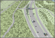
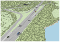
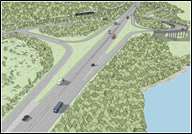
Three junction options were considered at Murthly/Birnam as described below and as shown by comparison, on Image 4.1:
- Murthly/Birnam Junction Option 1: (as preferred by the community) comprising a grade separated junction in the vicinity of the existing private access to Murthly Castle, with a diamond layout, facilitating all vehicle movements. An overbridge is provided across the A9, connecting to the B867 to the west. It also included connection of the B867 and Perth Road in the vicinity of the existing Birnam Junction, crossing the A9 via an underbridge.
- Murthly/Birnam Junction Option 2: comprising a grade separated junction in the vicinity of the existing Birnam Junction. Merge/diverge loops in the northbound direction connecting with the B867, and a merge slip road in the southbound direction, are included, with no southbound diverge slip road. The B867 and Perth Road are connected, crossing beneath the A9 via an underbridge. A separate underbridge to connect the existing private access to Murthly Castle to the B867 is also incorporated.
- Murthly/Birnam Junction Option 3: comprising a grade separated junction in the vicinity of the existing Birnam Junction. Merge/diverge loops in the northbound and southbound directions are included, facilitating all vehicle movements, with the southbound loop placed on a viaduct structure to reduce encroachment on the floodplain. The B867 and Perth Road are connected, crossing beneath the A9 via an underbridge. A separate underbridge to connect the existing private access to Murthly Castle to the B867 is also incorporated.
Junction arrangements at Dunkeld
Option ST2A, Option ST2B and Option ST2D all included an at-grade roundabout in the vicinity of the existing junction at Dunkeld which provides connections to the A9 (north and south), A923, A822 and road to Inver. Instead of an at-grade roundabout, Option ST2C included a grade separated junction in the vicinity of the existing Dunkeld Junction, facilitating all vehicle movements, with northbound and southbound slip roads.
The key features of the four route options are detailed in Table 4.2.
|
DMRB Stage 2 route options |
Description of key features |
|
Option ST2A (CPRO) |
Main Alignment: · On-line route, largely following the horizontal alignment of the existing A9 single carriageway. · A9 dual carriageway in a cut and cover tunnel for approximately 1.5 kilometres, commencing at the southern extent in the vicinity of the existing Birnam Junction and terminating approximately 300 metres south of the existing Dunkeld Junction. · Dunkeld & Birnam Station retained in its current position with Station Road reconnected to the station. Parking on top of the cut and cover tunnel. · Access road proposed to properties on Birnam Glen to the west of the station (in close proximity to Ladywell landfill site). · Speed limit of 50 miles per hour required between southern extent of scheme and proposed Dunkeld Junction to maintain safety within the tunnel section. 70mph speed limit for the remainder of the scheme. Murthly/Birnam Junction: · Grade separated junction in the vicinity of the existing private access to Murthly Castle. · Diamond layout, facilitating all vehicle movements. Overbridge provided across the A9, connecting to the B867 to the west. · Requires a connection of the B867 and Perth Road in the vicinity of the existing Birnam Junction, crossing beneath the A9 at the southern extent of the cut and cover tunnel. Dunkeld Junction: · At-grade roundabout in the vicinity of the existing junction at Dunkeld, including a segregated left lane between the A923 and A9 south. · Provides connections to the A9 (north and south), A923, A822 and road to Inver. The Hermitage (same for all proposed route options): · Left-in left-out junction on the northbound carriageway. Dalguise Junction (same for all proposed route options): · Grade separated junction south of the existing junction with the B898. · Loops in the northbound direction and slip roads in the southbound direction, facilitating all vehicle movements. · Realigned B898 crosses the A9 on an underbridge, connecting to a roundabout on the east of the A9, which also connects to the southbound slip roads. Construction: · Construction duration: 4 ½ to 5 years · Construction cost estimated to be between £1 billion to £1.6 billion. |
|
Option ST2B (Additional Whole Route Option 1) |
Main Alignment: · On-line route, largely following the horizontal alignment of the existing A9 single carriageway. · A9 dual carriageway lowered into a 150m underpass structure in the vicinity of Dunkeld & Birnam Station. · Dunkeld & Birnam Station retained in its current position with Station Road re-connected to the station. Parking on top of underpass. · Speed limit of 70 miles per hour throughout. · Access road proposed to properties on Birnam Glen to the west of the station (in close proximity to Ladywell landfill site). Murthly/Birnam Junction: · Grade separated junction in the vicinity of the existing Birnam Junction. · Loops in the northbound direction and a merge slip road in the southbound direction, with no southbound diverge slip road. · B867 and Perth Road connected, crossing the A9 via an underbridge. · Includes an underbridge to connect the existing private access to Murthly Castle to the B867. Dunkeld Junction: · As per description for Option ST2A. The Hermitage: · Same for all proposed route options – as per description for Option ST2A. Dalguise Junction: · Same for all proposed route options – as per description for Option ST2A. Construction: · Construction duration: 4 to 4 ½ years · Construction cost estimated to be between £420 million to £629 million. |
|
Option ST2C (Additional Whole Route Option 2) |
Main Alignment: · On-line route, largely following the horizontal and vertical alignment of the existing A9 single carriageway. · Generally, the same level as the existing A9 throughout, raised in the vicinity of Dunkeld Junction. · Dunkeld & Birnam Station retained in its current position. · Birnam Industrial Estate acquired, and the land used to construct a car parking facility accessed from Station Road, incorporating approximately fifty spaces. · A new pedestrian underpass structure, incorporating lifts, constructed below the proposed A9 dual carriageway, linking the new car park to the station. · Left-in left-out junction on the northbound carriageway to provide maintenance access to the station building. No public vehicular access available to the station building. · Speed limit of 70mph throughout. Murthly/Birnam Junction: · As per description for Option ST2B. Dunkeld Junction: · Grade separated junction in the vicinity of the existing Dunkeld Junction. · Variation of a diamond layout, facilitating all vehicle movements, with northbound and southbound slip roads. · A833 and A923 connected, crossing the A9 via an underbridge. The Hermitage: · Same for all proposed route options – as per description for Option ST2A. Dalguise Junction: · Same for all proposed route options – as per description for Option ST2A. Construction: · Construction duration: 2 ½ to 3 years · Construction cost estimated to be between £405 million to £546 million. |
|
Option ST2D (Additional Whole Route Option 3) |
Main Alignment: · On-line route, largely following the horizontal and vertical alignment of the existing A9 single carriageway. · Generally, the same level as the existing A9 throughout. · Dunkeld & Birnam Station retained in its current position. · Birnam Industrial Estate acquired, and the land used to construct a car parking facility accessed from Station Road, incorporating approximately fifty spaces. · A new pedestrian underpass structure, incorporating lifts, constructed below the proposed A9 dual carriageway, linking the new car park to the station. · Left-in left-out junction on the northbound carriageway to provide maintenance access to the station building. No public vehicular access available to the station building. · Speed limit of 70mph throughout. · Murthly/Birnam Junction: · As per Option description for Option ST2B. · Dunkeld Junction: · As per description for Option ST2A. · The Hermitage: · Same for all proposed route options – as per description for Option ST2A. · Dalguise Junction: · Same for all proposed route options – as per description for Option ST2A. · Construction: · Construction duration: 2 ½ to 3 years · Construction cost estimated to be between £303 million to £420 million. |
DMRB Stage 2 Assessment
The DMRB Stage 2 comparative assessment considered the environmental, engineering, traffic and economic differences and differentiators associated with the CPRO (Option ST2A), three Murthly/Birnam Junction options and the three Additional Whole Route Options (Option ST2B: A9 dual carriageway lowered into a 150m underpass structure; Option ST2C and Option ST2D: both on-line routes, largely following the horizontal and vertical alignment of the existing A9 single carriageway but with different Dunkeld Junction options).
The following key issues were considered:
- Murthly/Birnam Junction Assessment, including consideration of:
- impacts on ecology and designated environmental sites;
- traffic impacts on Perth Road; and
- noise impacts on sensitive receptors on Perth Road.
- Constructability, including complexity and duration of construction for the CPRO and the Additional Whole Route Options.
- Structures, including complexity and duration of construction.
- Materials, including:
- earthworks balance;
- import of earthworks and other materials;
- excavation of materials; and
- construction traffic movements.
- Impact on the Highland Main Line railway and Dunkeld & Birnam Station, including the consideration of its status as a Category A listed building.
- Landscape and visual impacts within a sensitive and narrow corridor.
- Noise and vibration impacts, during construction and operation.
- Road safety.
- Scheme cost and economics.
Significant differences were not identified that would eliminate junction options from further assessment. As such, to limit the number of Whole Route Options being assessed, allowing a more focussed assessment, the initial focus of the DMRB Stage 2 assessment was on the Murthly/Birnam Junction options.
Based on the preliminary findings of the DMRB Stage 2 assessment, it was recommended that Murthly/Birnam Junction Option 2, a grade separated junction in the vicinity of the existing Birnam Junction, with merge/diverge slip roads in the northbound direction and a merge slip road in the southbound direction, be taken forward as the preferred junction option and included in the three Additional Whole Route Options (Option ST2B, Option ST2C and Option ST2C). This junction option was comparatively assessed at DMRB Stage 2 as limiting construction within the River Tay floodplain, and also having the lowest overall effects on the landscape resource and lowest anticipated costs.
Reduced Cut and Cover Tunnel
Following further consultation with the Birnam to Ballinluig A9 Community Group in late 2019, further consideration was given to an option that incorporated a 450 metre long cut and cover tunnel, which was originally developed through the A9 Co-Creative Process.
It was concluded however, that although it had a reduced length of tunnel, the option would still have significant construction complexity, similar to the CPRO (Option ST2A), with an estimated construction duration of between four and four and a half years. Furthermore, it would also impact local watercourses and not fully address concerns noted from some local residents and stakeholders.
Emerging Preferred Route Option
Taking cognisance of the Murthly/Birnam Junction assessment and recommendation, the CPRO, along with the three Additional Route Options, were considered in terms of engineering, environmental and traffic and economic impacts.
Based on the preliminary findings of the DMRB Stage 2 assessment, and considering feedback from the public and other stakeholders, it was recommended that Additional Whole Route Option 3 (Option ST2D) be taken forward as the Emerging Preferred Route Option.
It was noted that the Emerging Preferred Route Option (Option ST2D) included the community’s favoured options, as voted during the A9 Co-Creative Process, at Dunkeld, The Hermitage and Dalguise. In addition, the junction option at Birnam was based on the principles of the community’s second preference for a junction, which was a grade separated, restricted movements junction with a northbound diverge slip road and a southbound merge slip road only. However, to partly address traffic increases on Perth Road with such an option, a northbound merge slip road was added. The Emerging Preferred Route Option (Option ST2D) also incorporated improved access to the station from Birnam via Station Road and a replacement car park, with the opportunity to enhance access further, a connection to Birnam being noted as important to the community.
A verification workshop confirmed Option ST2D as the Emerging Preferred Route Option.
Confirmation of Preferred Route
In late 2019 and early 2020, the DMRB was updated to provide a logical, consistent and clear format. To capture these changes to the guidance document, the DMRB Stage 2 assessment was revised, and a second verification workshop was held to consider the updated findings of the revised DMRB Stage 2 assessment and re-determine the Emerging Preferred Route Option.
The DMRB Stage 2 assessment, which was amended to incorporate the changes to the DMRB guidance, concluded that Option 2 is the preferred junction option at Murthly/Birnam and Additional Whole Route Option 3 (Option ST2D) is the Emerging Preferred Route Option.
A summary of the key findings of the DMRB Stage 2 assessment, (Jacobs, 2023), taking into account engineering, environmental and traffic and economic considerations, is provided in Table 4.3.
On the basis of the DMRB Stage 2 Route Option Assessment, the Emerging Preferred Route Option (Additional Whole Route Option 3 (Option ST2D)) was recommended to be taken forward as the preferred route for the proposed scheme. This was presented to Scottish Ministers for consideration. As this was different to the CPRO, (Option ST2A), this was presented to Scottish Ministers alongside the CPRO, as agreed as part of the A9 Co-Creative Process. The key reasons to support the recommendation of Option ST2D as the preferred route were as follows:
- The Emerging Preferred Route Option (Option ST2D) includes the community’s favoured options, as voted through the A9 Co-Creative Process, at Dunkeld, The Hermitage and Dalguise.
- In addition, the junction option at Birnam is based on the principle of the community’s second preference for a junction, which was a grade separated junction, restricted movements junction with a northbound diverge slip road and a southbound merge slip road only. However, to partly address traffic increases on Perth Road with such an option, a northbound merge slip road has been added.
- The Emerging Preferred Route Option (Option ST2D) also incorporates improved access to the station, with the opportunity to enhance further, which was noted as important to the local community.
On 20 December 2023, Option ST2D was confirmed by the Scottish Ministers as the Preferred Route Option for the proposed scheme.
|
Route Option |
Benefits |
Disbenefits |
|
Option ST2A |
· Reduced traffic flows on Perth Road (between Murthly Junction and Station Road) compared to the Do-Minimum scenario. · The joint lowest overall adverse effect on cultural heritage and includes a significant beneficial effect on the setting of the Category A Listed Dunkeld & Birnam Station from re-establishing the physical connection between the station and Birnam via Station Road. · Direct vehicular and pedestrian connection provides opportunities for the sustainable reuse of the station building. Potential for providing Equality Act 2010 compliant access between station platforms can be investigated in conjunction with Network Rail and Transport Scotland (Rail). · Provides the potential for creation of additional undesignated open space on top of the cut and cover tunnel, which could provide amenity space for the community. · Results in the fewest significant adverse effects and greatest number of significant beneficial effects in relation to operational noise, particularly for noise sensitive receptors in Birnam, when compared with the at-grade options (Option ST2C and Option ST2D). · Combination of the provision of additional open space and the beneficial effects in relation to noise results in the lowest overall effect on human health and wellbeing. |
· Speed limit of 50mph proposed for safety between the southern extent of the scheme and the proposed Dunkeld Junction, resulting in reduced travel time benefits. · Requires significant excavation to form the 1.5 kilometres cut and cover tunnel, with significant disposal and lorry movements. · Complex road drainage required, particularly due to the lowered road alignment, existing corridor topography and narrow corridor. · Construction of the 1.5 kilometre cut and cover tunnel in such a constrained and sensitive corridor will be complex, with tunnel walls constructed using 3,700 large diameter bored piles. Installation will require heavy plant in close proximity to residential properties, Dunkeld & Birnam Station and the Highland Main Line railway. · Includes an at-grade roundabout at Dunkeld, which is a Deviation from recommendations for a D2AP (sub-category c) standard. Possibility of queuing within the cut and cover tunnel in the event of an accident occurring on the roundabout. · Lowest level of economic benefits at the highest cost. · Construction duration and requirement for extensive piling results in the greatest overall effect on noise and vibration and human health during construction. · Scale and nature of construction results in the highest overall effect on material assets and waste, and climate. · Inchewan Burn would require to be lowered by approximately 8 metres, resulting in significant changes to its form and function, impacting fish passage and fragmenting habitat. · Potential for direct and indirect impacts on businesses and community assets during construction, given the 4 ½ to 5 years expected construction duration. · Acquisition of Birnam Industrial Estate, which requires demolition of commercial properties. · Significant effect on View from the Road and the Special Qualities of the NSA. · Although assessed as having the lowest overall effect on Cultural Heritage, there is a significant adverse effect on the setting of the Category A Listed Dunkeld & Birnam Station resulting from the loss of the station forecourt. |
|
Option ST2B |
· Includes a 70mph speed limit throughout, consistent with the overall A9 Dualling Programme. · The joint lowest overall adverse effect on cultural heritage and includes a significant beneficial effect on the setting of the Category A Listed Dunkeld & Birnam Station. · Direct vehicular and pedestrian connection provides opportunities for the sustainable reuse of the station building. Potential for providing Equality Act 2010 compliant access between station platforms can be investigated in conjunction with Network Rail and Transport Scotland (Rail). · Results in significant beneficial effects in relation to operational noise, particularly for noise sensitive receptors in Birnam with fewer significant adverse effects when compared with the at-grade options (Option ST2C and Option ST2D). · Does not require the acquisition of Birnam Industrial Estate. |
· Requires significant excavation to form the underpass structure, with significant disposal and lorry movements. · Complex road drainage required, particularly due to the lowered road alignment, existing corridor topography and narrow corridor. · Construction of the 150-metre-long underpass in such a constrained and sensitive corridor will be complex, with walls constructed using 860 large diameter bored piles. Installation will require heavy plant in close proximity to residential properties, Dunkeld & Birnam Station and the Highland Main Line railway. · Increases traffic flows on Perth Road (north and south of Station Road) through the omission of a southbound diverge slip road at Birnam Junction. · Includes an at-grade roundabout at Dunkeld, which is a Deviation from recommendations for a D2AP (sub-category c) standard. · Scale and nature of construction results in an intermediate overall effect on material assets and waste, and climate. · Inchewan Burn would require to be lowered by approximately 6 metres, resulting in significant changes to its form and function, impacting fish passage and fragmenting habitat. · Potential for direct and indirect impacts on businesses and community assets during construction, given the 4 to 4 ½ years expected construction duration. · Significant adverse effects on landscape as there is limited scope to integrate the underpass into the surrounding landscape. · Although assessed as having the lowest overall effect on Cultural Heritage, there is a significant adverse effect on the setting of the Category A Listed Dunkeld & Birnam Station resulting from the loss of the station forecourt. |
|
Option ST2C |
· Includes a 70mph speed limit throughout, consistent with the overall A9 Dualling Programme. · Incorporates grade separated junctions throughout, fully compliant with the D2AP (sub-category c) standard. · Provides the greatest travel time benefits for road users, due to the inclusion of grade separated junctions throughout. · No significant drainage issues anticipated. · Slight beneficial effect from the improved connection between the Category A Listed Dunkeld & Birnam Station and Birnam. · Replacement car park and pedestrian underpass would provide some opportunities for the sustainable re-use of the station building. · No direct impact on Inchewan Burn or fish passage. · Reduced direct and indirect impacts on businesses and community assets during construction. · Fewer significant adverse noise and vibration effects during construction than the lowered route options (Option ST2A and Option ST2B). · Equality Act 2010 compliant access to Dunkeld & Birnam Station and southbound platform through provision of a new underpass structure, with potential for providing compliant access to the northbound platform. |
· Requires import of acceptable fill material. · Requires construction of low-height retaining walls on the east side of the A9 to the immediate south of Dunkeld Junction. A further retaining wall (up to 14 metres in height) required in the locality of the River Braan crossing. · Increases traffic flows on Perth Road (north and south of Station Road) through the omission of a southbound diverge slip road at Birnam Junction. · No direct vehicular access to Dunkeld & Birnam Station, with parking provided on the site of Birnam Industrial Estate. · Scale and nature of construction results in an intermediate overall effect on material assets and waste, and climate. · Acquisition of Birnam Industrial Estate, which requires demolition of commercial properties. · Significant adverse impact on visual receptors and landscape character as a result of the raised vertical alignment and greater prominence of road infrastructure associated with the grade separated Dunkeld Junction. · Significant adverse effect on the setting of the Category A Listed Dunkeld & Birnam Station from the permanent loss of the forecourt and the visible presence of the carriageway. · Results in a reduced number of beneficial operational noise effects and increased number of adverse effects when compared to the lowered route options (Option ST2A and Option ST2B). |
|
Option ST2D |
· Includes a 70mph speed limit throughout, consistent with the overall A9 Dualling Programme. · Provides comparable operational benefits to the other options but at a lower cost, therefore performing better in economic terms. · No significant structures required. · No significant drainage issues anticipated. · Largely at-grade, therefore no significant excavations or embankments necessary. · No substantial piling activity. · Scale and nature of construction results in the lowest overall effect on material assets and waste, and climate. · Slight beneficial effect from the improved connection between the Category A Listed Dunkeld & Birnam Station and Birnam. · Replacement car park and pedestrian underpass would provide some opportunities for the sustainable re-use of the station building. · No direct impact on Inchewan Burn or fish passage. · Reduced direct and indirect impacts on businesses and community assets during construction. · Fewer significant adverse noise and vibration effects during construction. · Equality Act 2010 compliant access to Dunkeld & Birnam Station and southbound platform through provision of a new underpass structure, with potential for providing compliant access to the northbound platform. · Lowest overall effect on the River Tay (Dunkeld) NSA and its Special Qualities. · Lowest overall effect on visual amenity as much of the existing roadside vegetation would likely be maintained and views from adjacent visual receptors would be relatively unchanged. |
· Increases traffic flows on Perth Road (north and south of Station Road) through the omission of a southbound diverge slip road at Birnam Junction. · Includes an at-grade roundabout at Dunkeld, which is a Deviation from recommendations for a D2AP (sub-category c) standard. · No direct vehicular access to Dunkeld & Birnam Station, with parking provided on the site of Birnam Industrial Estate. · Acquisition of Birnam Industrial Estate, which requires demolition of commercial properties. · Significant adverse effect on the setting of the Category A Listed Dunkeld & Birnam Station from the permanent loss of the forecourt and the visible presence of the carriageway. · Results in a reduced number of beneficial operational noise effects and increased number of adverse effects, particularly in Birnam when compared to the lowered route options (Option ST2A and Option ST2B). |
Development of the Proposed Scheme Design
The Preferred Route Option (Option ST2D) was taken forward for further development as part of the DMRB Stage 3 scheme development and assessment (referred to in this EIAR as ‘the proposed scheme’).
During the DMRB Stage 3 assessment, the preferred route for Pass of Birnam to Tay Crossing was subject to further refinement as more detailed survey information was gathered. The DMRB Stage 3 provided enhancements to the mainline, junction and side road designs as presented in the DMRB Stage 2 Report, as well as additional flood modelling. The DMRB Stage 3 assessment also included the development of routes for WCH, design of facilities at Dunkeld & Birnam Station, access tracks, drainage and earthworks design, and the incorporation of embedded and essential mitigation to avoid or reduce potential impacts and significant residual effects on the environment.
The Pass of Birnam to Tay Crossing proposed scheme is described in Chapter 6 (The Proposed Scheme) and the design development undertaken during the DMRB Stage 3 design process is detailed in Chapter 5 (Iterative Design Development).
References
National Legislation and EU Directives
Not applicable.
Documents and Reports
- Jacobs (2016). A9 Dualling Programme, Pass of Birnam to Tay Crossing, Stage 2 Preliminary Options Review Report (November 2016).
- Jacobs (2023). A9 Dualling Programme: A9 Junctions and Accesses Strategy.
- Scott Wilson (2004). A9 Perth to Blair Atholl - Route Improvement Strategy Study. Scott Wilson (Scotland) Ltd, December 2005.
- Transport Scotland (2013). A9 Dualling Programme: Strategic Environmental Assessment – Environmental Report (June 2013). Non-technical Summary (Accessed February 2025).
- Transport Scotland (2014a). DMRB Stage 1 Assessment. A9 Dualling: Preliminary Engineering Services (PES).
- Transport Scotland (2014b). A9 Dualling Programme, Strategic Environmental Assessment (SEA), Environmental Report Addendum.
- Transport Scotland (2014c). A9 Dualling Programme: Strategic Environmental Assessment (SEA) – Post Adoption Statement (September 2014) (Accessed February 2025).
- Transport Scotland (2024). A9 Dualling Programme: Pass of Birnam to Tay Crossing – DMRB Stage 2 Scheme Assessment Report (Accessed February 2025).