Appendix H: Illustrating the likely ranges of random year-to-year variation in casualty rates for local authority roads for each local authority area
Reported Road Casualties Scotland 2018
Appendix H: Illustrating the likely ranges of random year-to-year variation in casualty rates for local authority roads for each local authority area
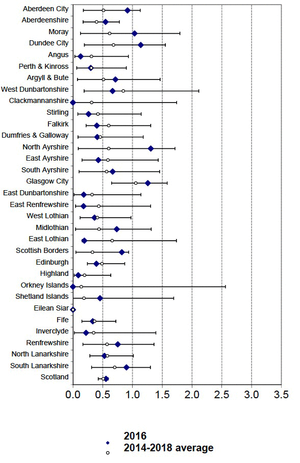
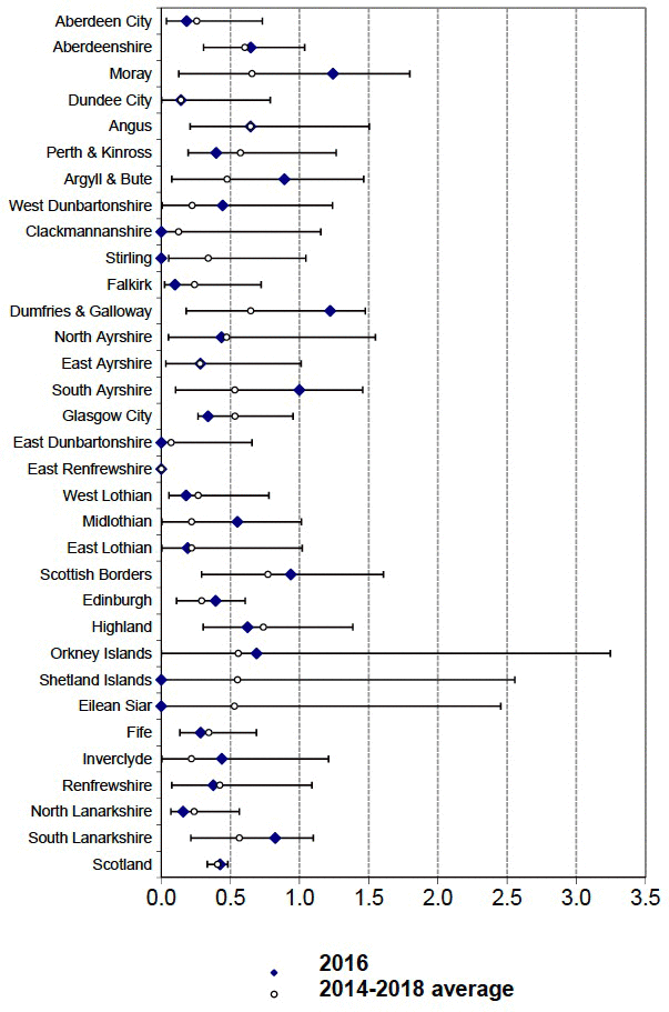
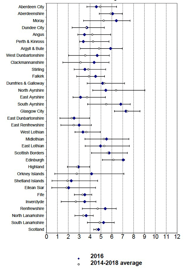
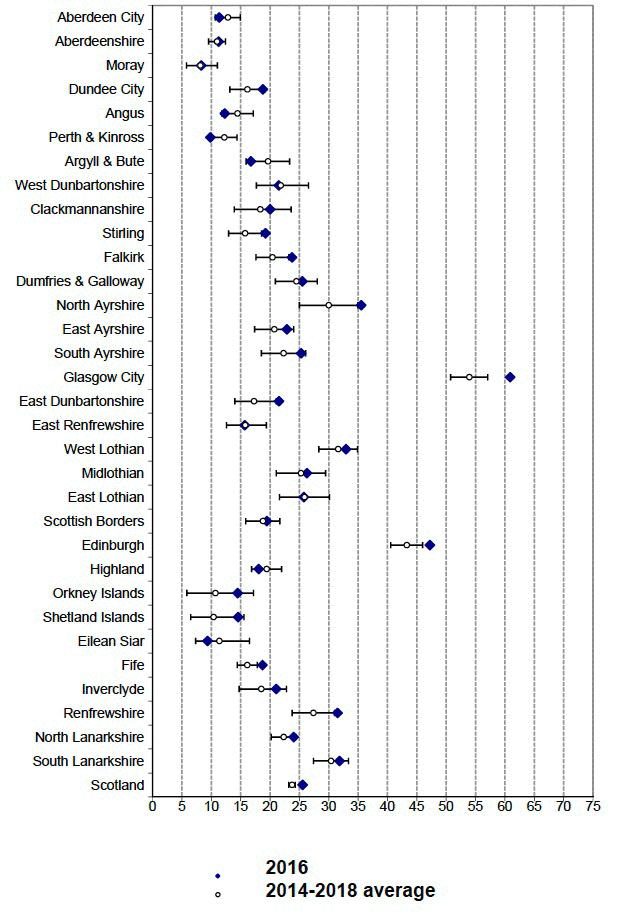
The following table and the accompanying charts were first published as Table 41 (b) in Road Accidents Scotland 2005 in November 2006 and have now been updated using data for 2014 to 2018 . They were initially prepared following a discussion, at a meeting of Liaison Group on Road Accident Statistics in June 2006, of the possible inclusion in Road Accidents Scotland of charts which compare road accident or casualty rates by local authority area, using a method which was described in a paper by Paul Hewson (Exeter University) in the June 2004 edition of Traffic Engineering and Control. This involves the production of so-called caterpillar plots. These are charts which show:
- the values in the latest year (or period) for each area, in order from lowest to highest (though in this case Local Authorities are grouped within police force area for ease of comparison); and
- the likely range of random statistical variation around each value (these indicate the likely maximum range of year-to-year variation in the figures due to the random nature of accidents – based on statistical theory, one would expect only 5% of values to be outwith this range)
Such charts allow one to see (for example) the kinds of areas which have the lowest rates, and whether certain areas' figures differ significantly (e.g. one can be sure that the values for two areas do differ significantly if there is no overlap between their likely ranges of random variation). Members of the Group felt that it would be useful to include such charts, but with some changes – for example, the local authorities should appear in the standard Road Accidents Scotland order, and the values should be provided in a table, for the benefit of those who wished to use the numbers.
The likely ranges of random year-to-year variation were calculated by assuming that the numbers of casualties are the outcome of a Poisson process (as in the Hewson paper). However, the method of calculation was simpler than that used by Hewson. The main features of the approach, which was applied using the numbers for each of the three types of casualty for each local authority area, are described below.
First, it was assumed that the annual average for a five year period provides the best estimate of the underlying rate of occurrence of casualties for the single year in the middle of that period. For example, it was assumed that the annual average for 2014 to 2018 provides the best estimate of the underlying rate of occurrence of casualties around 2018. This figure was then taken as representing the number of casualties that one would expect to arise in 2018, on the basis that these numbers are the outcome of a Poisson process.
A characteristic of a Poisson distribution is that the values of the mean and the (statistical) variance are the same. The annual average number of casualties for 2014 to 2018 was therefore used as the estimate of the variance of the number of casualties, and its square root was used as the estimate of the standard deviation of the number of casualties.
The likely range of random year-to-year variation around the expected number of casualties for 2018 was then estimated using the underlying rate for 2018 (the annual average for 2014 to 2018 ) and the estimated standard deviation. The ranges were calculated in a similar way to 95% confidence intervals – i.e.:
- if the relevant casualty count was less than 100, the ranges (like exact confidence intervals) were calculated using the inverse Chi-squared distribution, as a result of which:
- the ranges are not symmetric about the expected number of casualties;
- in cases where the numbers are small, it is not possible for the lower limit of the range to have a value of less than zero
- if the relevant casualty count was 100 or more, the Normal approximation was used – i.e. the range was based on the expected number of casualties plus or minus twice the estimated standard deviation
The estimated upper and lower limits to the likely ranges of casualty numbers were then divided by the traffic estimates (in 100s of million vehicle kilometres) to get the likely ranges of values of casualty rates (per 100 million vehicle-kilometres). As the traffic estimates tend to change only slightly from year to year, it was assumed, for simplicity, that they are not affected by any random variation (so there was no need to widen the confidence limits accordingly).
Two points should be noted:
- the calculation of the limits used the expected number of casualties (rather than the actual number of casualties) in 2018 in order to show how the actual casualty rate that arose in that year compares with the likely range of values for that year. This makes it easy to see which (if any) local authority areas had, by chance, casualty rates in 2018 that were particularly high (compared with the rates that would have been expected on the basis of the casualty numbers for the five year period centred on that year), and which areas had, by chance, particularly low casualty rates in 2018;
- the figures cover only local authority roads, in order that any comparison of the figures for different local authorities is not affected by the casualty rates of any trunk roads in those areas. Transport Scotland is responsible for the trunk road network – not local authorities. In general, Motorways and trunk A roads have lower accident rates than other types of road (as can be seen from Table 5[c]), so areas which have a higher proportion of traffic on (say) Motorways may tend to have lower casualty rates. Therefore, any comparison of the casualty rates for a number of local authority areas (such as the four large cities) will be more meaningful if the figures relate only to local authority roads and therefore are unaffected by any differences in the proportions of traffic on (say) Motorways in those areas.
The table presents the estimated limits of the likely ranges of values in 2018 for each of the three casualty rates for each local authority area. It also shows the corresponding actual casualty rate for 2018. The four charts show the numbers graphically. It will be seen that most of the actual rates fall within the likely ranges of values – but the following numbers of cases do not:
- (all ages) fatal casualty rate - one case;
- slight casualty rate - seven cases
Such out of range numbers are not a cause of concern, given that one would expect about 5% of cases to be outwith the estimated ranges (with 32 local authorities, one would expect a couple of cases outwith the likely ranges for each of the three casualty rates). While seven out of range cases of the slight casualty rate is more than one would expect, it is not so many as to suggest that something is wrong with the method of calculating the ranges. Most of the out of range cases are only slightly outwith the likely ranges; and there is no suggestion of any clear bias in the figures, because some of them are above the upper limit and others are below the lower limit. In any case, one might expect that there would be more cases of out of range values for the slight casualty rate, because the numbers of casualties from which it is calculated are much higher than the numbers from which the other two rates are calculated. As mentioned in Appendix G) the larger the number, the smaller that the level of likely random variation is as a percentage of the value, and therefore the more likely it is that external factors (e.g. the results of various road safety measures) will have an effect which is greater than that which would be expected due to random year-to-year variation alone – and, therefore, the more likely it is that there will be out-of-range values.
http://www.transportscotland.gov.uk/analysis/statistics
| Child Killed and Seriously Injured casualty rate 2016 | Likely range of values | All ages Killed casualty rate 2016 | Likely range of values | All ages Seriously injured casualty rate 2016 | Likely range of values | Slight casualty rate 2016 | Likely range of values | |||||
|---|---|---|---|---|---|---|---|---|---|---|---|---|
| Lower | Upper | Lower | Upper | Lower | Upper | Lower | Upper | |||||
| North East | ||||||||||||
| Aberdeen City | 0.92 | 0.17 | 1.13 | 0.18 | 0.04 | 0.73 | 4.58 | 3.71 | a6.44 | 11.4 | 10.7 | 14.9 |
| Aberdeenshire | 0.55 | 0.17 | 0.78 | 0.65 | 0.31 | 1.04 | 6.08 | 4.85 | 6.96 | 11.3 | 9.5 | 12.4 |
| Moray | 1.04 | 0.13 | 1.80 | 1.24 | 0.13 | 1.80 | 6.42 | 3.40 | 7.68 | 8.3 | 5.8 | 11.0 |
| Tayside | ||||||||||||
| Dundee City | 1.14 | 0.19 | 1.55 | 0.14 | 0.00 | 0.79 | 3.70 | 2.35 | 5.31 | 18.8 | 13.2 | 19.1 |
| Angus | 0.13 | 0.03 | 0.93 | 0.65 | 0.21 | 1.50 | 3.49 | 2.87 | 5.90 | 12.3 | 11.8 | 17.1 |
| Perth & Kinross | 0.30 | 0.06 | 0.90 | 0.40 | 0.20 | 1.26 | 3.38 | 3.05 | 5.75 | 9.9 | 10.0 | 14.4 |
| Argyll & West Dunbartonshire | ||||||||||||
| Argyll & Bute | 0.71 | 0.08 | 1.46 | 0.89 | 0.08 | 1.46 | 5.88 | 3.10 | 6.96 | 16.8 | 15.9 | 23.3 |
| West Dunbartonshire | 0.67 | 0.19 | 2.11 | 0.44 | 0.01 | 1.24 | 4.66 | 2.03 | 5.77 | 21.5 | 17.7 | 26.5 |
| Forth Valley | ||||||||||||
| Clackmannanshire | 0.00 | 0.01 | 1.74 | 0.00 | 0.00 | 1.15 | 4.38 | 1.50 | 5.75 | 20.0 | 13.9 | 23.6 |
| Stirling | 0.26 | 0.08 | 1.15 | 0.00 | 0.05 | 1.05 | 3.53 | 2.54 | 5.44 | 19.2 | 12.9 | 18.5 |
| Falkirk | 0.40 | 0.22 | 1.31 | 0.10 | 0.02 | 0.72 | 4.51 | 2.77 | 5.33 | 23.7 | 17.6 | 23.2 |
| Dumfries & Galloway | 0.41 | 0.08 | 1.18 | 1.22 | 0.18 | 1.48 | 5.16 | 3.73 | 7.18 | 25.5 | 20.9 | 28.0 |
| Ayrshire | ||||||||||||
| North Ayrshire | 1.31 | 0.09 | 1.71 | 0.44 | 0.05 | 1.55 | 5.45 | 4.25 | 9.04 | 35.5 | 25.0 | 34.9 |
| East Ayrshire | 0.43 | 0.15 | 1.43 | 0.28 | 0.03 | 1.01 | 3.13 | 2.43 | 5.41 | 22.9 | 17.4 | 24.0 |
| South Ayrshire | 0.67 | 0.10 | 1.46 | 1.00 | 0.10 | 1.46 | 6.82 | 3.77 | 7.70 | 25.3 | 18.5 | 26.1 |
| Greater Glasgow | ||||||||||||
| Glasgow City | 1.26 | 0.65 | 1.58 | 0.34 | 0.27 | 0.95 | 7.30 | 6.24 | 8.59 | 60.9 | 50.8 | 57.1 |
| East Dunbartonshire | 0.18 | 0.02 | 1.14 | 0.00 | 0.00 | 0.66 | 2.53 | 1.23 | 3.96 | 21.5 | 14.0 | 21.1 |
| East Renfrewshire | 0.18 | 0.04 | 1.30 | 0.00 | 0.00 | 0.00 | 3.00 | 1.32 | 4.13 | 15.7 | 12.6 | 19.4 |
| Lothians & Scottish Borders | ||||||||||||
| West Lothian | 0.36 | 0.12 | 0.97 | 0.18 | 0.05 | 0.78 | 3.35 | 2.61 | 4.94 | 32.9 | 28.3 | 34.9 |
| Midlothian | 0.74 | 0.04 | 1.31 | 0.55 | 0.00 | 1.01 | 5.51 | 3.53 | 7.57 | 26.3 | 21.1 | 29.5 |
| East Lothian | 0.19 | 0.15 | 1.74 | 0.19 | 0.00 | 1.02 | 4.96 | 3.55 | 7.61 | 25.8 | 21.6 | 30.1 |
| Scottish Borders | 0.82 | 0.05 | 0.94 | 0.94 | 0.29 | 1.61 | 5.74 | 4.13 | 7.43 | 19.5 | 15.9 | 21.7 |
| Edinburgh | 0.39 | 0.24 | 0.87 | 0.39 | 0.11 | 0.61 | 7.04 | 5.13 | 7.17 | 47.2 | 40.6 | 46.0 |
| Highlands & Islands | ||||||||||||
| Highland | 0.09 | 0.02 | 0.63 | 0.62 | 0.30 | 1.39 | 2.94 | 1.92 | 3.97 | 18.1 | 16.9 | 22.0 |
| Orkney Islands | 0.00 | 0.00 | 2.56 | 0.69 | 0.00 | 3.25 | 4.14 | 0.76 | 7.11 | 14.5 | 5.8 | 17.2 |
| Shetland Islands | 0.45 | 0.00 | 1.69 | 0.00 | 0.01 | 2.56 | 2.27 | 0.50 | 4.70 | 14.5 | 6.5 | 15.6 |
| Eilean Siar | 0.00 | - | - | 0.00 | 0.01 | 2.45 | 2.03 | 0.48 | 4.51 | 9.3 | 7.3 | 16.5 |
| Fife | 0.33 | 0.15 | 0.72 | 0.29 | 0.13 | 0.69 | 3.52 | 2.56 | 4.16 | 18.7 | 14.4 | 17.8 |
| Renfrewshire & Inverclyde | ||||||||||||
| Inverclyde | 0.22 | 0.02 | 1.39 | 0.44 | 0.01 | 1.21 | 3.51 | 1.35 | 4.55 | 21.1 | 14.7 | 22.8 |
| Lanarkshire | ||||||||||||
| Renfrewshire | 0.75 | 0.17 | 1.36 | 0.38 | 0.08 | 1.09 | 5.40 | 3.29 | 6.41 | 31.5 | 23.8 | 31.0 |
| North Lanarkshire | 0.53 | 0.28 | 1.01 | 0.16 | 0.07 | 0.56 | 3.65 | 2.61 | 4.30 | 24.0 | 20.2 | 24.4 |
| South Lanarkshire | 0.90 | 0.31 | 1.30 | 0.82 | 0.21 | 1.10 | 5.24 | 3.75 | 6.22 | 31.8 | 27.4 | 33.4 |
| Scotland | 0.55 | 0.42 | 0.59 | 0.42 | 0.33 | 0.48 | 4.78 | 4.34 | 4.84 | 25.5 | 23.2 | 24.3 |
Child KSI Casualty Rate on Local Authority Roads (per 100 million veh-kms) by LA: 2016 and likely range of values (see text) around the 2014-2018 average

All Ages Fatal Casualty Rate on Local Authority roads (per 100 million veh-kms)by LA: 2016 and likely range of values (see text) around the 2014-2018 average

All Ages Serious Casualty Rate on Local Authority roads (per 100 million veh-kms)by LA: 2016 and likely range of values (see text) around the 2014-2018 average

Slight Casualty Rate on Local Authority roads (per 100 million veh-kms) by LA: 2016 and likely range of values (see text) around the 2014-2018 average
