Chapter 5: Road Traffic
Chapter 5: Road Traffic
Road Traffic
1 Introduction
1.1 This chapter provides information about road traffic, such as the total volume of traffic by type of road, by type of vehicle, and by council area. It also provides some figures on traffic flows at selected points on the road network, some statistics on delays and congestion and information about petrol and diesel consumption.
1.2 Traffic estimates, indicate only the broad level of traffic, so year - on - year comparisons should be made with care as they are based on a very small cross-section of the roads in Scotland: 12 hours in one day traffic counts taken at around 750 sites per year and data from automatic traffic counters at about two dozen sites in Scotland (then combined with data from automatic counters at similar sites in England and Wales). See Sources section.
Key Points
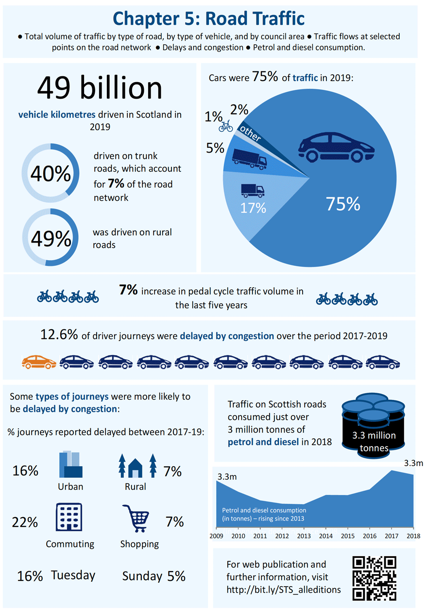
- 49 billion vehicle km were driven in 2019
- 40% of distance travelled is on Trunk roads, which account for only 7% of the road network.
- 12.6% of driver journeys were delayed by congestion between 2017 and 2019.
2 Main Points
Major and Minor Roads
2.1 The estimated volume of traffic on Scotland's roads in 2019 was around 49 billion (thousand million) vehicle km: 1% more than 2018. There have been slight increases in the last eight years, following the steady downward trend seen between 2007 and 2011. (Table 5.1)
2.2 The total volume of traffic on major roads (Motorways and A roads) in 2019 was estimated to be 32 billion vehicle-km. Traffic on Motorways accounted for 8.7 billion vehicle km (18% of all traffic). This was less than the estimated 10.8 billion vehicle km on trunk A roads (22% of the total), and the 12.7 billion on non-trunk A roads (26%). Seventy per cent of A road traffic was in rural areas: 16 billion out of the A roads total of 24 billion vehicle km. (Table 5.1)
2.3 Minor roads (B, C and unclassified roads) accounted for the remaining 34% of traffic in 2019: an estimated 16.5 billion vehicle km (Table 5.1)
2.5 The total volume of traffic on major roads (Motorways and A roads) in 2019 was 2% higher than in the previous year (Motorways increased by 1.6%). Minor road traffic was about 0.8% lower than in 2018. Traffic levels are around 10 per cent higher than in 2009. (Table 5.1)
Trends
2.6 DfT estimates suggest a rising trend in traffic volumes on major roads in Scotland, reaching a peak in 2007 when numbers levelled off, 5 per cent higher than they had been in 2003. Traffic volumes then fell back slightly but after increases since 2011 are now 9% higher than they were in 2007. Motorway traffic saw a 14 per cent rise between 2003 and 2008, fell slightly over the next two years and has started to rise again over the last seven years; now 30% higher than the earlier peak in 2008. (Table 5.1)
2.7 Traffic on minor roads is estimated to have risen by 9% between 2003 and 2007, falling by 6% between then and 2012, before rising again. The total volume of traffic on all roads in Scotland was also estimated to have risen by 6% between 2003 and 2007, falling by 2% between then and 2011, before rising again. (Table 5.1)
2.8 Cars account for over three quarters (75%) of the total volume of traffic on the roads (i.e. of the total for major roads and minor roads combined), light goods vehicles for 17% and heavy goods vehicles for 5%. Pedal cycle traffic increased by 17% in 2019. However, with pedal cycle traffic volumes increasing by 28% since 2009, pedal cycles still account for less than one percent of estimated traffic volume. (Table 5.2 & 5.3)
2.9 In 2019, the volume of car traffic was 7 per cent higher than in 2009, light goods vehicle traffic 35 per cent higher, but bus vehicle traffic 11% lower. (Table 5.3)
Local Area volumes
2.10 Nearly a fifth of motorway traffic was within the City of Glasgow, whereas Highland had the highest volume (26%) of trunk A road traffic. The five local authorities with the highest traffic volumes (Glasgow, North Lanarkshire, Edinburgh, Fife and Aberdeenshire) account for 34% of all traffic on Scotland's roads. (Table 5.4)
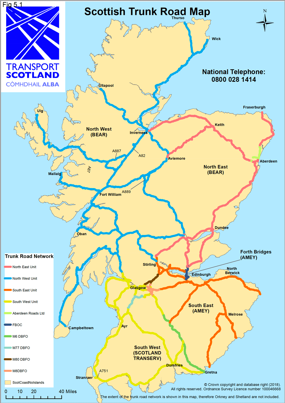
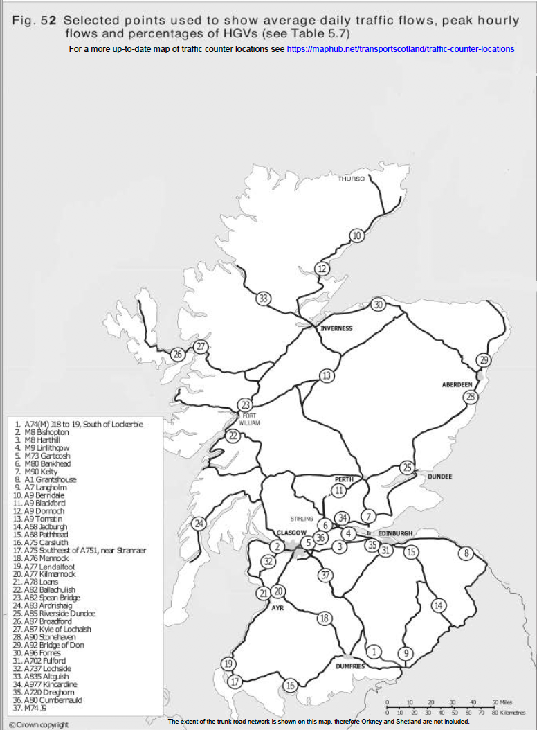
2.11 The monthly average daily traffic flows recorded at a selection of Automated Traffic Classifier (ATC) sites are given in Table 5.6. A map showing the location of the traffic counters and detailed information can be found here https://ntds.trafficscotland.org/ The average flow (both directions) at the M8 Harthill site was 56,312 vehicles per day. In contrast, the average daily flow at the A83 Ardrishaig site was around 2,165 vehicles. Traffic levels also vary considerably depending on the month: e.g. the A82 Spean Bridge site in March averaged around 651 vehicles per day – compared to 6,542 in August. (Table 5.6 & 5.7)
2.12 Some trunk road traffic flows are given in Table 5.7. The M8 Harthill was the busiest site from this sample, with an annual average of 56,312 vehicles per day in 2019. Its Monday-Friday average was 52,236 vehicles per day. The M8 Harthill had the highest Monday-Friday peak hourly flows at 3,579 vehicles in the morning and 4,180 vehicles in the evening. At the opposite end of the scale, the A83 Ardrishaig averaged 2,165 vehicles per day over the year as a whole and its Monday-Friday peak hourly flows were 258 in the morning and 285 in the afternoon. Both the M74 Junction 9 and the A75 Carsluith had the highest percentage of heavy goods vehicle traffic in 2019 at 23% for the week, followed by the A82 Spean Bridge (20%). (Table 5.7)
Delays and Congestion
2.13 In previous editions of STS Table 5.8 estimated the time lost by traffic due to delays on trunk road routes monitored by Transport Scotland. This table is no longer being updated due to number of factors, including major changes to the network which would have required a substantial rework to the methodology.
2.14 The Scottish Household Survey provides estimates of delays attributed to congestion experienced by drivers (on the previous day). Between 2017 and 2019, 12.6% of journeys made as the driver of a car were said to be delayed due to traffic congestion. This figure is broadly comparable to congestion level peak in 2007 of around 14%. Short delays were more common than longer ones - 4% of car drivers' journeys were delayed by around 5 minutes compared to 2% by 15 minutes and 3% by 20 minutes or longer. Weekday journeys were most likely to suffer congestion delays between 7 and 9 am and 4 and 6 pm (24-26% and 24-27% respectively). Fewer delays (7%) were experienced by people residing in remote small towns than those in accessible small towns (12%). (Tables 5.8 and 5.9)
2.15 These statistics no longer feature in Scotland's National Indicator on driver congestion in their old form. More information on National Indicators can be found on the Scotland Performs website: http://www.gov.scot/About/Performance/scotPerforms/indicator/congestion
2.16 Delays experienced by bus users have fallen since 2008, though changes in recent years are not significant due to small sample sizes. (Table 5.9)
Fuel Consumption
2.17 DECC estimates suggest that the traffic on Scotland's roads consumed just over 3 million tonnes of petrol and diesel in 2018. This figure includes fuel purchased outwith Scotland which is consumed in Scotland, and excludes fuel purchased in Scotland which is used outwith Scotland. It is estimated using information about average fuel consumption, vehicle emissions and traffic volumes - see Notes and Definitions section.
2.18 Petrol and diesel consumption has been rising since 2013. There has been a steady fall in petrol consumption in cars over the period and an increase in diesel cars, reflecting trends in vehicle propulsion shown in Chapter 1 i.e. increases in the proportion of diesel powered vehicles on the roads and reductions in petrol powered vehicles. (Table 5.10)
Fig 5.1
| 2009 | 2010 1 | 2011 1 | 2012 1 | 2013 1 | 2014 1 | 2015 1 | 2016 1 | 2017 1 | 2018 1 | 2019 1 | |
|---|---|---|---|---|---|---|---|---|---|---|---|
| million vehicle kilometres | |||||||||||
| Major roads (M and A) | |||||||||||
| Motorways | 6,633 | 6,503 | 6,570 | 7,140 | 7,262 | 7,421 | 7,477 | 7,829 | 8,054 | 8,518 | 8,654 |
| Trunk A roads | |||||||||||
| Urban * | 952 | 945 | 951 | 973 | 960 | 965 | 960 | 988 | 1,832 | 1,764 | 1,744 |
| Rural * | 8,960 | 8,773 | 8,793 | 8,678 | 8,766 | 8,726 | 8,905 | 9,160 | 8,633 | 8,856 | 9,100 |
| Total | 9,913 | 9,719 | 9,744 | 9,651 | 9,725 | 9,691 | 9,864 | 10,147 | 10,466 | 10,620 | 10,844 |
| Non - trunk A roads | |||||||||||
| Urban * | 4,530 | 4,522 | 4,471 | 4,395 | 4,390 | 4,478 | 4,501 | 4,609 | 5,466 | 5,325 | 5,399 |
| Rural * | 7,885 | 7,752 | 7,781 | 7,666 | 7,670 | 7,856 | 8,029 | 8,262 | 7,420 | 7,079 | 7,314 |
| Total | 12,415 | 12,273 | 12,252 | 12,061 | 12,061 | 12,334 | 12,530 | 12,871 | 12,887 | 12,404 | 12,713 |
| All A roads | |||||||||||
| Urban * | 5,482 | 5,467 | 5,422 | 5,368 | 5,350 | 5,443 | 5,461 | 5,597 | 7,298 | 7,089 | 7,143 |
| Rural * | 16,845 | 16,525 | 16,574 | 16,344 | 16,436 | 16,582 | 16,934 | 17,422 | 16,053 | 15,935 | 16,414 |
| Total | 22,327 | 21,992 | 21,996 | 21,712 | 21,786 | 22,025 | 22,395 | 23,019 | 23,351 | 23,024 | 23,557 |
| All major roads | 28,961 | 28,495 | 28,566 | 28,852 | 29,048 | 29,446 | 29,872 | 30,848 | 31,405 | 31,542 | 32,211 |
| B roads | |||||||||||
| Urban * | 1,283 | 1,274 | 1,306 | 1,340 | 1,350 | 1,410 | 1,440 | 1,463 | 1,876 | 2,100 | 2,100 |
| Rural * | 2,661 | 2,634 | 2,526 | 2,428 | 2,420 | 2,532 | 2,553 | 2,561 | 2,468 | 2,346 | 2,361 |
| Total | 3,944 | 3,908 | 3,833 | 3,768 | 3,769 | 3,943 | 3,993 | 4,025 | 4,344 | 4,446 | 4,460 |
| C & Unclassified roads | |||||||||||
| Urban * | 6,942 | 6,611 | 6,527 | 6,454 | 6,256 | 6,297 | 6,183 | 6,134 | 7,225 | 7,175 | 7,066 |
| Rural * | 4,371 | 4,481 | 4,481 | 4,498 | 4,836 | 5,277 | 5,506 | 5,690 | 5,061 | 5,011 | 4,976 |
| Total | 11,314 | 11,092 | 11,008 | 10,953 | 11,092 | 11,574 | 11,689 | 11,823 | 12,286 | 12,186 | 12,043 |
| All minor roads | |||||||||||
| Urban * | 8,225 | 7,885 | 7,833 | 7,794 | 7,606 | 7,707 | 7,623 | 7,597 | 9,100 | 9,275 | 9,166 |
| Rural * | 7,033 | 7,115 | 7,008 | 6,926 | 7,256 | 7,810 | 8,059 | 8,251 | 7,529 | 7,357 | 7,337 |
| All minor roads | 15,258 | 15,000 | 14,841 | 14,720 | 14,861 | 15,517 | 15,683 | 15,848 | 16,630 | 16,632 | 16,503 |
| All roads | |||||||||||
| Motorways | 6,633 | 6,503 | 6,570 | 7,140 | 7,262 | 7,421 | 7,477 | 7,829 | 8,054 | 8,518 | 8,654 |
| Urban * | 13,708 | 13,352 | 13,255 | 13,161 | 12,956 | 13,150 | 13,084 | 13,194 | 16,399 | 16,365 | 16,309 |
| Rural * | 23,878 | 23,640 | 23,581 | 23,271 | 23,692 | 24,392 | 24,993 | 25,672 | 23,583 | 23,292 | 23,751 |
| All roads | 44,219 | 43,496 | 43,406 | 43,573 | 43,909 | 44,963 | 45,555 | 46,696 | 48,036 | 48,175 | 48,714 |
Source: Department for Transport - Not National Statistics
1. Estimates for the period since 2010 have been revised to take into account the minor road benchmarking exercise. Further details available at:
https://www.gov.uk/government/publications/road-traffic-statistics-minor-road-benchmarking
* DfT's classification of urban and rural roads differs from the built up/non-built up classification - see section 5.1.4 of the traffic estimates notes and definitions at the back of this publication.
Totals may not equal sum of parts due to rounding.
| Cars | Two wheeled motor vehicles | Buses | Light goods vehicles | Heavy goods vehicles | All motor vehicles | Pedal cycles | All vehicle traffic | Percent of all roads | |
|---|---|---|---|---|---|---|---|---|---|
| million vehicle kilometres | |||||||||
| Major roads (M and A) | |||||||||
| Motorways 1 | 6,271 | 26 | 46 | 1,373 | 938 | 8,654 | 0 | 8,654 | 17.8 |
| Trunk A roads - urban 2 | 1,359 | 8 | 12 | 264 | 99 | 1,742 | 1 | 1,744 | 3.6 |
| Trunk A roads - rural 2 | 6,693 | 74 | 76 | 1,491 | 760 | 9,094 | 6 | 9,100 | 18.7 |
| Non-trunk A roads - urban 2 | 4,355 | 22 | 88 | 749 | 157 | 5,372 | 27 | 5,399 | 11.1 |
| Non-trunk A roads - rural 2 | 5,442 | 57 | 85 | 1,300 | 414 | 7,298 | 17 | 7,314 | 15.0 |
| All major roads | 24,120 | 187 | 307 | 5,177 | 2,368 | 32,160 | 51 | 32,211 | 66.1 |
| Minor roads (B, C and unclassified) | |||||||||
| Urban roads 2 | 7,223 | 57 | 216 | 1,419 | 83 | 8,997 | 169 | 9,166 | 18.8 |
| Rural roads 2 | 5,405 | 81 | 40 | 1,529 | 134 | 7,190 | 147 | 7,337 | 15.1 |
| All minor roads | 12,628 | 138 | 256 | 2,948 | 218 | 16,187 | 316 | 16,503 | 33.9 |
| All roads | |||||||||
| Motorways | 6,271 | 26 | 46 | 1,373 | 938 | 8,654 | 0 | 8,654 | 17.8 |
| Urban roads 2 | 12,937 | 87 | 316 | 2,432 | 340 | 16,111 | 197 | 16,309 | 33.5 |
| Rural roads 2 | 17,540 | 212 | 201 | 4,321 | 1,308 | 23,582 | 170 | 23,751 | 48.8 |
| All roads | 36,747 | 324 | 563 | 8,126 | 2,586 | 48,347 | 367 | 48,714 | 100.0 |
| Percentage of all vehicles | 75.4 | 0.7 | 1.2 | 16.7 | 5.3 | 99.2 | 0.8 | 100.0 | |
Source: Department for Transport - Not National Statistics
1. Motorways include A(M) roads.
2. DfT's classification of urban and rural roads differs from the built up/non-built up classification - see section 5.1.4 of the notes and definitions at the back of this publication.
Totals may not equal sum of parts due to rounding.
| 2009 | 2010 1 | 2011 1 | 2012 1 | 2013 1 | 2014 1 | 2015 1 | 2016 1 | 2017 1 | 2018 1 | 2019 1 | |
|---|---|---|---|---|---|---|---|---|---|---|---|
| million vehicle kilometres | |||||||||||
| Major roads (M and A) | |||||||||||
| Cars | 22,496 | 21,998 | 21,986 | 22,170 | 22,217 | 22,418 | 22,573 | 23,220 | 23,453 | 23,470 | 24,119 |
| Two wheeled motor vehicles | 196 | 181 | 181 | 171 | 176 | 184 | 181 | 180 | 181 | 182 | 186 |
| Buses | 329 | 353 | 352 | 363 | 365 | 366 | 369 | 351 | 337 | 316 | 308 |
| Light goods vehicles | 3,684 | 3,701 | 3,816 | 3,906 | 4,032 | 4,242 | 4,481 | 4,765 | 5,032 | 5,165 | 5,178 |
| Heavy goods vehicles | 2,210 | 2,217 | 2,184 | 2,198 | 2,210 | 2,193 | 2,228 | 2,290 | 2,362 | 2,365 | 2,368 |
| All motor vehicle traffic | 28,917 | 28,450 | 28,519 | 28,807 | 29,001 | 29,404 | 29,831 | 30,807 | 31,366 | 31,499 | 32,160 |
| Pedal cycles | 45 | 46 | 47 | 45 | 47 | 42 | 41 | 41 | 40 | 44 | 51 |
| All traffic on major roads | 28,961 | 28,496 | 28,565 | 28,853 | 29,048 | 29,446 | 29,872 | 30,847 | 31,406 | 31,542 | 32,211 |
| Cars | 11,895 | 11,595 | 11,597 | 11,616 | 11,632 | 12,073 | 12,214 | 12,264 | 12,721 | 12,910 | 12,628 |
| Two wheeled motor vehicles | 125 | 109 | 115 | 121 | 112 | 115 | 114 | 111 | 128 | 131 | 138 |
| Buses | 306 | 297 | 254 | 219 | 238 | 239 | 214 | 204 | 234 | 184 | 256 |
| Light goods vehicles | 2,343 | 2,412 | 2,316 | 2,229 | 2,315 | 2,477 | 2,556 | 2,761 | 3,055 | 2,899 | 2,948 |
| Heavy goods vehicles | 347 | 334 | 300 | 271 | 282 | 286 | 284 | 260 | 241 | 239 | 218 |
| All motor vehicle traffic | 15,016 | 14,748 | 14,582 | 14,456 | 14,579 | 15,189 | 15,382 | 15,601 | 16,378 | 16,363 | 16,187 |
| Pedal cycles | 243 | 253 | 258 | 264 | 282 | 327 | 300 | 247 | 252 | 269 | 316 |
| All traffic on minor roads | 15,258 | 15,000 | 14,841 | 14,720 | 14,861 | 15,517 | 15,683 | 15,848 | 16,630 | 16,632 | 16,503 |
| All roads | |||||||||||
| Cars | 34,392 | 33,593 | 33,583 | 33,786 | 33,849 | 34,491 | 34,786 | 35,484 | 36,174 | 36,381 | 36,747 |
| Two wheeled motor vehicles | 322 | 290 | 296 | 292 | 288 | 299 | 295 | 292 | 309 | 314 | 324 |
| Buses | 635 | 649 | 606 | 582 | 604 | 605 | 583 | 555 | 571 | 500 | 563 |
| Light goods vehicles | 6,027 | 6,113 | 6,132 | 6,135 | 6,348 | 6,719 | 7,036 | 7,527 | 8,087 | 8,064 | 8,126 |
| Heavy goods vehicles | 2,557 | 2,551 | 2,484 | 2,469 | 2,492 | 2,479 | 2,512 | 2,550 | 2,602 | 2,604 | 2,586 |
| All motor vehicle traffic | 43,932 | 43,197 | 43,101 | 43,263 | 43,580 | 44,593 | 45,213 | 46,407 | 47,744 | 47,862 | 48,347 |
| Pedal cycles | 287 | 298 | 305 | 310 | 329 | 369 | 342 | 288 | 292 | 313 | 367 |
| All traffic on all roads | 44,219 | 43,496 | 43,406 | 43,573 | 43,909 | 44,963 | 45,555 | 46,696 | 48,036 | 48,175 | 48,714 |
Source: Department for Transport - Not National Statistics
1. Estimates for the period since 2010 have been revised to take into account the minor road benchmarking exercise. Further details available at: https://www.gov.uk/government/publications/road-traffic-statistics-minor-road-benchmarking
Totals may not equal sum of parts due to rounding.
| Council | All motorways 2 | Trunk A urban | Trunk A rural | Non-trunk A urban | Non-trunk A rural | Total: All major roads (M and A) | Minor roads (B, C and unclassified) | Total: all roads |
|---|---|---|---|---|---|---|---|---|
| million vehicle kilometres | ||||||||
| Aberdeen City | - | 24 | 276 | 410 | 147 | 857 | 711 | 1,568 |
| Aberdeenshire | - | 54 | 846 | 121 | 916 | 1,937 | 1,404 | 3,342 |
| Angus | - | - | 366 | 105 | 295 | 766 | 411 | 1,177 |
| Argyll & Bute | - | 9 | 450 | 53 | 267 | 778 | 213 | 991 |
| Clackmannanshire | - | - | 16 | 52 | 93 | 161 | 178 | 339 |
| Dumfries & Galloway | 793 | 42 | 620 | 79 | 318 | 1,853 | 394 | 2,247 |
| Dundee City | - | 163 | 8 | 176 | 13 | 360 | 469 | 829 |
| East Ayrshire | 118 | 24 | 241 | 96 | 220 | 700 | 446 | 1,146 |
| East Dunbartonshire | - | - | - | 119 | 100 | 219 | 343 | 562 |
| East Lothian | - | 1 | 418 | 69 | 174 | 662 | 375 | 1,036 |
| East Renfrewshire | 232 | 6 | 47 | 89 | 33 | 407 | 378 | 785 |
| Edinburgh, City of | 423 | 184 | 354 | 665 | 251 | 1,877 | 1,211 | 3,088 |
| Eilean Siar | - | - | - | 10 | 151 | 160 | 73 | 233 |
| Falkirk | 634 | - | 23 | 217 | 194 | 1,068 | 579 | 1,647 |
| Fife | 389 | 103 | 578 | 334 | 502 | 1,907 | 1,216 | 3,123 |
| Glasgow, City of | 1,596 | 9 | - | 700 | 42 | 2,348 | 1,211 | 3,559 |
| Highland | - | 134 | 1,618 | 64 | 569 | 2,384 | 642 | 3,026 |
| Inverclyde | - | 150 | 50 | 57 | 17 | 274 | 261 | 535 |
| Midlothian | - | - | 146 | 92 | 170 | 408 | 321 | 730 |
| Moray | - | 53 | 247 | 40 | 158 | 497 | 324 | 821 |
| North Ayrshire | - | 127 | 201 | 88 | 115 | 530 | 283 | 813 |
| North Lanarkshire | 1,142 | 155 | 20 | 435 | 236 | 1,989 | 1,346 | 3,336 |
| Orkney Islands | - | - | - | 12 | 75 | 87 | 68 | 155 |
| Perth & Kinross | 503 | 53 | 1,112 | 114 | 381 | 2,162 | 457 | 2,619 |
| Renfrewshire | 554 | 77 | 186 | 196 | 94 | 1,107 | 517 | 1,624 |
| Scottish Borders | - | 30 | 375 | 57 | 440 | 902 | 402 | 1,305 |
| Shetland Islands | - | - | - | 21 | 133 | 154 | 77 | 231 |
| South Ayrshire | - | 42 | 388 | 115 | 113 | 658 | 394 | 1,052 |
| South Lanarkshire | 1,220 | 179 | 136 | 268 | 375 | 2,178 | 641 | 2,820 |
| Stirling | 292 | 9 | 262 | 127 | 355 | 1,045 | 312 | 1,357 |
| West Dunbartonshire | - | 116 | 115 | 159 | 47 | 437 | 228 | 665 |
| West Lothian | 756 | - | - | 258 | 321 | 1,336 | 616 | 1,952 |
| Scotland | 8,654 | 1,744 | 9,100 | 5,399 | 7,314 | 32,211 | 16,503 | 48,714 |
1. Source: Department for Transport - Not National Statistics. They provide only a rough estimate of the likely total volume of traffic on roads in each area. For further information, please see the notes on the traffic estimates at the back of the publication.
2. Motorways include A(M) roads.
Totals may not equal sum of parts due to rounding.
| 2009 | 2010 4 | 2011 4 | 2012 4 | 2013 4 | 2014 4 | 2015 4 | 2016 4 | 2017 4 | 2018 4 | 2019 4 | |
|---|---|---|---|---|---|---|---|---|---|---|---|
| million vehicle kilometres | |||||||||||
| Trunk roads 2 | |||||||||||
| Aberdeen City | 253 | 255 | 258 | 263 | 260 | 264 | 263 | 273 | 267 | 271 | 300 |
| Aberdeenshire | 829 | 822 | 824 | 861 | 872 | 902 | 908 | 948 | 1,040 | 952 | 901 |
| Angus 3 | 324 | 335 | 334 | 343 | 357 | 370 | 358 | 367 | 372 | 364 | 366 |
| Argyll & Bute | 359 | 352 | 353 | 351 | 355 | 362 | 376 | 392 | 419 | 456 | 459 |
| Dumfries & Galloway | 1,290 | 1,274 | 1,270 | 1,252 | 1,272 | 1,311 | 1,349 | 1,387 | 1,467 | 1,444 | 1,455 |
| Dundee City | 182 | 180 | 178 | 186 | 182 | 169 | 168 | 173 | 171 | 174 | 171 |
| East Ayrshire 3 | 375 | 366 | 365 | 365 | 359 | 374 | 369 | 352 | 349 | 381 | 383 |
| East Lothian | 359 | 354 | 355 | 349 | 349 | 359 | 362 | 391 | 414 | 407 | 419 |
| East Renfrewshire | 181 | 172 | 208 | 205 | 209 | 214 | 230 | 237 | 234 | 288 | 285 |
| Edinburgh, City of | 725 | 677 | 712 | 700 | 719 | 715 | 755 | 779 | 777 | 933 | 961 |
| Falkirk | 550 | 531 | 537 | 577 | 580 | 581 | 608 | 647 | 639 | 649 | 657 |
| Fife | 879 | 848 | 839 | 820 | 833 | 842 | 841 | 878 | 895 | 1,023 | 1,070 |
| Glasgow, City of 3 | 1,302 | 1,288 | 1,313 | 1,481 | 1,522 | 1,510 | 1,499 | 1,548 | 1,572 | 1,543 | 1,605 |
| Highland | 1,556 | 1,530 | 1,535 | 1,528 | 1,546 | 1,557 | 1,614 | 1,675 | 1,720 | 1,732 | 1,752 |
| Inverclyde | 75 | 72 | 72 | 71 | 71 | 72 | 73 | 75 | 67 | 68 | 200 |
| Midlothian | 141 | 135 | 136 | 140 | 138 | 143 | 136 | 141 | 143 | 145 | 146 |
| Moray | 269 | 263 | 264 | 265 | 266 | 270 | 274 | 286 | 287 | 299 | 300 |
| North Ayrshire | 326 | 318 | 317 | 309 | 308 | 316 | 320 | 326 | 319 | 316 | 327 |
| North Lanarkshire | 1,154 | 1,161 | 1,129 | 1,414 | 1,402 | 1,253 | 1,191 | 1,217 | 1,289 | 1,323 | 1,318 |
| Perth & Kinross | 1,332 | 1,299 | 1,324 | 1,296 | 1,322 | 1,363 | 1,381 | 1,467 | 1,608 | 1,679 | 1,667 |
| Renfrewshire 3 | 711 | 693 | 699 | 689 | 703 | 732 | 758 | 774 | 771 | 806 | 817 |
| Scottish Borders | 390 | 382 | 388 | 386 | 387 | 394 | 406 | 419 | 404 | 410 | 405 |
| South Ayrshire | 381 | 384 | 384 | 379 | 379 | 387 | 395 | 406 | 409 | 422 | 430 |
| South Lanarkshire 3 | 1,197 | 1,162 | 1,163 | 1,219 | 1,236 | 1,261 | 1,264 | 1,328 | 1,395 | 1,501 | 1,535 |
| Stirling | 499 | 481 | 478 | 470 | 468 | 485 | 500 | 544 | 544 | 554 | 564 |
| West Dunbartonshire | 209 | 204 | 205 | 206 | 206 | 213 | 220 | 223 | 220 | 228 | 231 |
| West Lothian | 700 | 682 | 675 | 671 | 688 | 693 | 724 | 724 | 730 | 753 | 756 |
| Total trunk roads | 16,546 | 16,222 | 16,313 | 16,791 | 16,987 | 17,112 | 17,342 | 17,977 | 18,519 | 19,138 | 19,498 |
| Aberdeen City | 1,075 | 1,048 | 1,029 | 1,024 | 1,021 | 1,043 | 1,047 | 1,060 | 1,069 | 1,065 | 1,268 |
| Aberdeenshire | 1,933 | 1,913 | 1,896 | 1,878 | 1,936 | 2,048 | 2,113 | 2,162 | 2,267 | 2,242 | 2,441 |
| Angus | 752 | 742 | 735 | 728 | 734 | 761 | 777 | 792 | 821 | 815 | 811 |
| Argyll & Bute | 541 | 534 | 530 | 520 | 532 | 551 | 562 | 574 | 581 | 531 | 533 |
| Clackmannanshire 3 | 316 | 313 | 315 | 311 | 304 | 315 | 320 | 326 | 331 | 318 | 322 |
| Dumfries & Galloway | 708 | 703 | 699 | 684 | 696 | 724 | 743 | 761 | 801 | 794 | 791 |
| Dundee City | 703 | 679 | 673 | 663 | 646 | 656 | 651 | 652 | 653 | 656 | 658 |
| East Ayrshire 3 | 674 | 671 | 669 | 658 | 671 | 699 | 716 | 735 | 784 | 766 | 763 |
| East Dunbartonshire | 547 | 532 | 528 | 521 | 514 | 529 | 530 | 535 | 558 | 562 | 562 |
| East Lothian | 503 | 504 | 503 | 492 | 499 | 524 | 536 | 548 | 605 | 617 | 618 |
| East Renfrewshire 3 | 565 | 554 | 543 | 530 | 528 | 543 | 547 | 555 | 554 | 504 | 500 |
| Edinburgh, City of | 2,253 | 2,194 | 2,164 | 2,140 | 2,120 | 2,168 | 2,181 | 2,202 | 2,186 | 2,142 | 2,128 |
| Eilean Siar | 206 | 203 | 204 | 205 | 210 | 218 | 224 | 253 | 238 | 236 | 233 |
| Falkirk | 955 | 947 | 949 | 939 | 940 | 968 | 977 | 992 | 1,011 | 1,000 | 990 |
| Fife | 2,015 | 2,004 | 2,009 | 1,993 | 2,012 | 2,087 | 2,112 | 2,150 | 2,229 | 2,065 | 2,053 |
| Glasgow, City of 3 | 2,089 | 2,027 | 1,998 | 1,968 | 1,959 | 1,986 | 1,955 | 1,971 | 1,964 | 1,964 | 1,953 |
| Highland | 1,067 | 1,061 | 1,055 | 1,039 | 1,067 | 1,117 | 1,143 | 1,168 | 1,228 | 1,259 | 1,274 |
| Inverclyde | 458 | 446 | 440 | 433 | 430 | 442 | 443 | 447 | 457 | 453 | 334 |
| Midlothian | 520 | 518 | 520 | 509 | 510 | 532 | 546 | 559 | 584 | 583 | 584 |
| Moray | 460 | 454 | 449 | 454 | 462 | 486 | 495 | 506 | 531 | 523 | 522 |
| North Ayrshire | 456 | 453 | 451 | 437 | 436 | 453 | 459 | 467 | 491 | 494 | 486 |
| North Lanarkshire | 1,871 | 1,838 | 1,825 | 1,816 | 1,814 | 1,862 | 1,872 | 1,891 | 1,971 | 2,027 | 2,018 |
| Orkney Islands | 137 | 136 | 135 | 134 | 137 | 145 | 149 | 153 | 157 | 155 | 155 |
| Perth & Kinross | 960 | 951 | 944 | 935 | 956 | 999 | 1,029 | 1,053 | 1,061 | 967 | 952 |
| Renfrewshire 3 | 766 | 757 | 753 | 748 | 749 | 771 | 779 | 789 | 805 | 813 | 806 |
| Scottish Borders | 808 | 800 | 796 | 786 | 796 | 829 | 852 | 872 | 916 | 903 | 899 |
| Shetland Islands | 203 | 203 | 205 | 203 | 208 | 216 | 223 | 229 | 233 | 232 | 231 |
| South Ayrshire | 602 | 597 | 594 | 577 | 575 | 596 | 605 | 617 | 636 | 627 | 622 |
| South Lanarkshire | 1,294 | 1,285 | 1,278 | 1,266 | 1,267 | 1,314 | 1,333 | 1,362 | 1,382 | 1,289 | 1,284 |
| Stirling 3 | 751 | 749 | 737 | 724 | 728 | 757 | 770 | 785 | 801 | 802 | 794 |
| West Dunbartonshire | 438 | 427 | 426 | 427 | 423 | 432 | 431 | 435 | 436 | 437 | 433 |
| West Lothian | 1,046 | 1,035 | 1,043 | 1,040 | 1,042 | 1,077 | 1,093 | 1,115 | 1,174 | 1,195 | 1,195 |
| Total LA roads | 27,673 | 27,274 | 27,092 | 26,781 | 26,922 | 27,851 | 28,213 | 28,719 | 29,516 | 29,036 | 29,216 |
1. Source: Department for Transport - Not National Statistics. They provide only a rough estimate of the likely total volume of traffic on roads in each area. For further information, please see the notes on the traffic estimates in the text.
2. Roads which changed from trunk to local authority, or vice versa, are counted according to their status on a recent date, rather than on the basis of their status in each year. NB: to save space, Councils which do not have trunk roads in their areas are not shown.
3. DfT have made some minor changes to the traffic estimates from 2006 onwards. This was due to incorrect LA codes being assigned to a few sections of major road.
4. Estimates for the period since 2010 have been revised to take into account the minor road benchmarking exercise. Further details available at: https://www.gov.uk/government/publications/road-traffic-statistics-minor-road-benchmarking
Totals may not equal sum of parts due to rounding.
| 2009 | 2010 3 | 2011 3 | 2012 3 | 2013 3 | 2014 3 | 2015 3 | 2016 3 | 2017 3 | 2018 3 | 2019 3 | |
|---|---|---|---|---|---|---|---|---|---|---|---|
| million vehicle kilometres | |||||||||||
| All roads | |||||||||||
| Aberdeen City | 1,329 | 1,302 | 1,286 | 1,288 | 1,281 | 1,307 | 1,310 | 1,333 | 1,336 | 1,337 | 1,568 |
| Aberdeenshire | 2,762 | 2,734 | 2,719 | 2,739 | 2,808 | 2,950 | 3,020 | 3,110 | 3,307 | 3,194 | 3,342 |
| Angus 2 | 1,075 | 1,077 | 1,069 | 1,070 | 1,091 | 1,131 | 1,135 | 1,159 | 1,193 | 1,179 | 1,177 |
| Argyll & Bute | 900 | 886 | 883 | 871 | 886 | 913 | 938 | 966 | 1,000 | 987 | 991 |
| Clackmannanshire 2 | 316 | 313 | 315 | 311 | 304 | 315 | 320 | 326 | 331 | 334 | 339 |
| Dumfries & Galloway | 1,998 | 1,977 | 1,968 | 1,935 | 1,967 | 2,035 | 2,092 | 2,147 | 2,268 | 2,238 | 2,247 |
| Dundee City | 885 | 859 | 850 | 848 | 829 | 825 | 819 | 825 | 824 | 829 | 829 |
| East Ayrshire 2 | 1,050 | 1,037 | 1,033 | 1,022 | 1,030 | 1,073 | 1,085 | 1,087 | 1,133 | 1,147 | 1,146 |
| East Dunbartonshire | 547 | 532 | 528 | 521 | 514 | 529 | 530 | 535 | 558 | 562 | 562 |
| East Lothian | 862 | 858 | 858 | 841 | 848 | 884 | 898 | 939 | 1,020 | 1,024 | 1,036 |
| East Renfrewshire 2 | 747 | 726 | 751 | 735 | 737 | 757 | 777 | 792 | 788 | 792 | 785 |
| Edinburgh, City of | 2,978 | 2,872 | 2,876 | 2,840 | 2,838 | 2,883 | 2,936 | 2,981 | 2,963 | 3,075 | 3,088 |
| Eilean Siar | 206 | 203 | 204 | 205 | 210 | 218 | 224 | 253 | 238 | 236 | 233 |
| Falkirk | 1,505 | 1,478 | 1,485 | 1,516 | 1,520 | 1,549 | 1,586 | 1,639 | 1,649 | 1,649 | 1,647 |
| Fife | 2,894 | 2,852 | 2,847 | 2,813 | 2,845 | 2,930 | 2,953 | 3,027 | 3,124 | 3,088 | 3,123 |
| Glasgow, City of 2 | 3,390 | 3,315 | 3,312 | 3,449 | 3,481 | 3,496 | 3,454 | 3,519 | 3,536 | 3,507 | 3,559 |
| Highland | 2,623 | 2,591 | 2,590 | 2,568 | 2,613 | 2,673 | 2,757 | 2,844 | 2,947 | 2,991 | 3,026 |
| Inverclyde | 533 | 517 | 512 | 504 | 501 | 515 | 516 | 523 | 524 | 521 | 535 |
| Midlothian | 661 | 653 | 656 | 648 | 648 | 676 | 683 | 700 | 727 | 728 | 730 |
| Moray | 729 | 716 | 713 | 719 | 728 | 756 | 770 | 792 | 818 | 822 | 821 |
| North Ayrshire | 782 | 770 | 768 | 746 | 744 | 769 | 779 | 793 | 811 | 811 | 813 |
| North Lanarkshire | 3,025 | 2,999 | 2,955 | 3,229 | 3,216 | 3,115 | 3,062 | 3,108 | 3,261 | 3,349 | 3,336 |
| Orkney Islands | 137 | 136 | 135 | 134 | 137 | 145 | 149 | 153 | 157 | 155 | 155 |
| Perth & Kinross | 2,292 | 2,250 | 2,268 | 2,231 | 2,278 | 2,362 | 2,410 | 2,520 | 2,669 | 2,647 | 2,619 |
| Renfrewshire 2 | 1,477 | 1,450 | 1,453 | 1,437 | 1,452 | 1,503 | 1,536 | 1,564 | 1,577 | 1,619 | 1,624 |
| Scottish Borders | 1,198 | 1,182 | 1,184 | 1,171 | 1,184 | 1,224 | 1,257 | 1,291 | 1,319 | 1,313 | 1,305 |
| Shetland Islands | 203 | 203 | 205 | 203 | 208 | 216 | 223 | 229 | 233 | 232 | 231 |
| South Ayrshire | 983 | 981 | 978 | 955 | 954 | 983 | 1,000 | 1,023 | 1,045 | 1,049 | 1,052 |
| South Lanarkshire 2 | 2,491 | 2,447 | 2,441 | 2,485 | 2,502 | 2,575 | 2,598 | 2,690 | 2,777 | 2,790 | 2,820 |
| Stirling 2 | 1,249 | 1,230 | 1,215 | 1,194 | 1,196 | 1,241 | 1,270 | 1,329 | 1,345 | 1,356 | 1,357 |
| West Dunbartonshire | 646 | 631 | 632 | 632 | 629 | 644 | 652 | 658 | 655 | 666 | 665 |
| West Lothian | 1,747 | 1,717 | 1,718 | 1,711 | 1,730 | 1,770 | 1,816 | 1,839 | 1,904 | 1,948 | 1,952 |
| Total all roads | 44,219 | 43,496 | 43,406 | 43,573 | 43,909 | 44,963 | 45,555 | 46,696 | 48,036 | 48,175 | 48,714 |
1. Source: Department for Transport - Not National Statistics. They provide only a rough estimate of the likely total volume of traffic on roads in each area. For further information, please see the notes on the traffic estimates in the text.
2. DfT have made some minor changes to the traffic estimates from 2006 to 2013. This was due to incorrect LA codes being assigned to a few sections of major road.
3. Estimates for the period since 2010 have been revised to take into account the minor road benchmarking exercise. Further details available at: https://www.gov.uk/government/publications/road-traffic-statistics-minor-road-benchmarking
Totals may not equal sum of parts due to rounding.
Fig 5.2
| Description | Jan | Feb | Mar | Apr | May | Jun | Jul | Aug | Sep | Oct | Nov | Dec |
|---|---|---|---|---|---|---|---|---|---|---|---|---|
| M74 J18 to J19 | 27,662 | 31,179 | 31,949 | 37,139 | 37,027 | 37,324 | 41,207 | 42,309 | 37,577 | 36,473 | 32,470 | 31,170 |
| M8 Bishopton | - | - | 26,811 | 26,750 | 27,499 | 27,039 | 27,525 | 28,624 | 27,244 | 27,366 | 26,489 | 23,884 |
| M8 Harthill | 49,264 | 54,134 | 56,756 | 58,327 | 59,250 | 58,762 | 59,280 | 61,222 | 57,124 | 55,135 | 54,273 | 52,095 |
| M9 Linlithgow | - | - | - | 34,816 | 36,119 | 35,631 | 24,159 | 37,021 | 36,512 | 31,024 | 33,599 | 29,882 |
| M73 Gartcosh | - | - | - | - | - | - | - | - | - | - | - | - |
| M74 J9 | - | - | - | - | - | - | - | - | 38,519 | 38,000 | - | 34,951 |
| M80 Bankhead | 3,982 | 4,634 | 38,938 | 40,376 | 40,735 | 39,985 | 41,091 | 42,270 | 40,670 | - | - | - |
| M90 Kelty | 14,571 | 22,705 | 15,898 | 30,125 | 34,366 | 35,417 | 35,092 | 36,308 | 34,881 | 33,514 | 31,714 | 28,789 |
| A1 Grantshouse | - | - | - | - | - | - | - | - | - | - | - | - |
| A7 Langholm | 3,348 | 3,573 | 3,635 | 3,775 | - | 3,866 | 3,930 | 3,953 | 3,885 | 3,789 | 3,695 | 3,623 |
| A9 Berridale | - | - | - | - | - | - | - | - | - | - | - | - |
| A9 Blackford | - | - | - | - | - | - | - | - | - | - | - | - |
| A9 Dornoch | - | - | - | 7,124 | 7,425 | 7,707 | 8,182 | 8,489 | 7,603 | 6,881 | 5,887 | 5,795 |
| A9 Tomatin | 7,743 | 8,830 | 9,232 | 11,227 | 11,549 | 11,867 | 12,870 | 13,844 | 11,940 | 11,091 | 9,287 | 8,461 |
| A68 Jedburgh | - | - | - | - | - | - | - | - | - | - | - | - |
| A68 Pathhead | 8,409 | 9,247 | 9,518 | 10,171 | 10,576 | 10,575 | 10,263 | 11,004 | 10,830 | 10,363 | 9,728 | 8,932 |
| A75 Carsluith | - | - | - | 5,229 | 5,402 | 5,257 | 5,770 | 6,093 | 5,355 | 4,935 | 4,562 | 4,557 |
| A75 Southeast of A751 | - | 6,774 | 6,733 | 7,013 | 7,276 | 7,013 | 7,350 | 7,467 | 6,935 | 6,425 | 6,690 | 6,292 |
| A76 Mennock | - | - | - | - | - | - | - | - | - | - | - | - |
| A77 Lendalfoot | - | - | - | - | - | - | - | - | - | - | - | - |
| A77 Kilmarnock | 25,147 | 27,512 | 27,751 | 30,282 | 29,628 | 29,092 | 30,268 | 28,101 | 28,635 | 28,659 | 27,133 | 24,576 |
| A78 Loans | - | - | - | 19,432 | 19,903 | 19,282 | 19,091 | 21,067 | 19,580 | 19,506 | 18,628 | 18,309 |
| A80 Cumbernauld | - | - | - | - | - | - | - | - | - | - | - | - |
| A82 Ballachulish | - | - | - | 6,411 | 7,226 | 7,180 | 7,561 | 8,275 | 6,710 | 5,361 | 3,838 | 3,220 |
| A82 Spean Bridge | 1,144 | 1,364 | 651 | 3,189 | 5,522 | 5,492 | 5,930 | 6,542 | 5,057 | 4,095 | 2,923 | 2,546 |
| A83 Ardrishaig | - | - | - | 3,059 | 3,282 | 304 | - | 1,869 | 3,119 | 2,856 | 2,625 | 2,467 |
| A85 Riverside Dundee | 15,744 | 17,073 | 17,094 | 17,701 | 17,736 | 17,449 | 17,369 | 18,127 | 17,543 | 16,188 | 17,234 | 15,987 |
| A87 Broadford | 3,472 | 3,921 | 4,374 | 6,277 | 7,415 | 7,470 | 7,961 | 8,498 | 6,963 | 5,241 | 4,376 | 3,847 |
| A87 Kyle of Lochalsh | 1,002 | 3,448 | 3,889 | 5,321 | 6,178 | 6,133 | 6,536 | 7,205 | 5,881 | 4,742 | 3,585 | 3,146 |
| A90 Stonehaven | - | - | - | - | - | - | - | 29,167 | 26,892 | 27,161 | 27,145 | 26,460 |
| A90 Bridge of Don | - | - | - | - | - | - | - | - | - | - | - | - |
| A96 Forres | 9,665 | 10,600 | 11,107 | 11,967 | 12,240 | 12,384 | 12,973 | 13,359 | 12,278 | 11,798 | 11,279 | 10,383 |
| A702 Fulford | - | - | - | - | - | - | - | - | 10,383 | - | - | - |
| A720 Dreghorn | - | - | - | - | - | - | - | - | - | - | - | - |
| A737 Lochside | 20,145 | 21,413 | 21,581 | 22,963 | 22,454 | 22,388 | 22,480 | 23,090 | 22,530 | 22,847 | 21,180 | 20,145 |
| A835 Aultguish | - | - | - | - | - | - | - | - | - | - | - | - |
| A977 Kincardine | 3,918 | 4,242 | 4,231 | 4,467 | 4,544 | 4,608 | 4,510 | 4,573 | 4,582 | 4,339 | 4,654 | 4,385 |
Source: Transport Scotland - Not National Statistics
1. Traffic flows are counted in both directions at ATC sites and the average flows are based on totals.
2. Missing data for these sites is due to equipment failure.
| Location | Site No. in Fig 5.2 | Average Daily Flow | HGV (Year) Percentage | Peak Hourly Flows | |||||||
|---|---|---|---|---|---|---|---|---|---|---|---|
| 7 Day | 5 Day | AM | PM | ||||||||
| Year | August | Year | August | 7 Day | 5 Day | 7 Day | 5 Day | 7 Day | 5 Day | ||
| M74 J18 to J19 | 1 | 35,156 | 42,309 | 37,349 | 44,242 | 2,606 | 2,649 | ||||
| M8 Bishopton | 2 | 26,931 | 28,624 | 18,672 | 14 | 15 | 1,373 | 1,785 | 1,609 | 1,808 | |
| M8 Harthill | 3 | 56,312 | 61,222 | 52,236 | 8 | 8 | 2,956 | 3,579 | 3,829 | 4,180 | |
| M9 Linlithgow | 4 | 35,447 | 37,021 | 39,287 | 40,702 | 8 | 10 | 2,622 | 3,390 | 3,002 | 3,418 |
| M73 Gartcosh | 5 | ||||||||||
| M74 J9 | 37 | 38,237 | 44,368 | 23 | 23 | ||||||
| M80 Bankhead | 6 | 34,296 | 42,270 | 39,795 | 16 | 18 | 2,453 | 2,991 | 3,155 | 3,404 | |
| M90 Kelty | 7 | 29,493 | 36,308 | ||||||||
| A1 Grantshouse | 8 | 8,999 | 9,379 | 4 | 5 | 727 | 716 | 732 | 759 | ||
| A7 Langholm | 9 | 3,740 | 3,953 | 4,039 | 4,247 | 16 | 18 | 280 | 301 | 311 | 339 |
| A9 Berridale | 10 | ||||||||||
| A9 Blackford | 11 | ||||||||||
| A9 Dornoch | 12 | 7,297 | 8,489 | 7,204 | 8,848 | 8 | 10 | 531 | 553 | 604 | 628 |
| A9 Tomatin | 13 | 10,708 | 13,844 | ||||||||
| A68 Jedburgh | 14 | ||||||||||
| A68 Pathhead | 15 | 11,004 | |||||||||
| A75 Carsluith | 16 | 5,266 | 6,093 | 5,329 | 6,393 | 23 | 25 | 381 | 400 | 404 | 429 |
| A75 Southeast of A751 | 17 | 6,863 | 7,467 | 3,167 | 245 | 262 | 275 | 295 | |||
| A76 Mennock | 18 | ||||||||||
| A77 Lendalfoot | 19 | ||||||||||
| A77 Kilmarnock | 20 | 28,063 | 28,101 | 27,683 | 4 | 5 | 1,817 | 2,233 | 2,238 | 2,390 | |
| A78 Loans | 21 | 19,453 | 21,067 | 21,033 | 22,043 | 5 | 5 | 1,537 | 1,937 | 1,719 | 1,972 |
| A80 Cumbernauld | 36 | ||||||||||
| A82 Ballachulish | 22 | 6,184 | 8,275 | 5,490 | 8,123 | 9 | 11 | 485 | 462 | 515 | 493 |
| A82 Spean Bridge | 23 | 3,902 | 6,542 | 4,016 | 6,556 | 20 | 22 | 353 | 350 | 385 | 378 |
| A83 Ardrishaig | 24 | 2,165 | 1,869 | 3,070 | 3,432 | 11 | 13 | 214 | 258 | 251 | 285 |
| A85 Riverside Dundee | 25 | 17,088 | 18,127 | 17,622 | 3 | 3 | 1,355 | 1,690 | 1,476 | 1,609 | |
| A87 Broadford | 26 | 5,829 | 8,498 | ||||||||
| A87 Kyle of Lochalsh | 27 | 4,771 | 7,205 | 2,731 | 2 | 2 | 190 | 203 | 236 | 252 | |
| A90 Stonehaven | 28 | 27,448 | 29,167 | 29,433 | 31,048 | 11 | 13 | 1,881 | 2,227 | 2,366 | 2,641 |
| A90 Bridge of Don | 29 | ||||||||||
| A96 Forres | 30 | 11,674 | 13,359 | ||||||||
| A702 Fulford | 31 | 10,626 | 12,442 | 4 | 4 | 811 | 1,056 | 1,057 | 1,207 | ||
| A720 Dreghorn | 35 | ||||||||||
| A737 Lochside | 32 | 21,952 | 23,090 | ||||||||
| A835 Aultguish | 33 | ||||||||||
| A977 Kincardine | 34 | 4,424 | 4,573 | 4,804 | 4,986 | 6 | 7 | 290 | 344 | 386 | 432 |
Source: Transport Scotland - Not National Statistics
1. 7 day flows were calculated from Monday to Sunday inclusive, '5 day flows' were calculated from Monday to Friday inclusive
2. Missing data for some sites is due to equipment failure. Year averages may be based only on data for part of the year, in cases where equipment was not working in some months.
| Location | Site No in Fig 5.2 | 2010 | 2011 | 2012 | 2013 | 2014 | 2015 | 2016 | 2017 | 2018 | 2019 |
|---|---|---|---|---|---|---|---|---|---|---|---|
| M74 J18 to J19 | 1 | 31,047 | 31,164 | 30,902 | 31,410 | 32,906 | 33,313 | 34,718 | .. | 34,694 | 35,156 |
| M8 Bishopton | 2 | 24,563 | 24,186 | 24,059 | 25,318 | 25,475 | .. | 16,766 | 18,954 | 25,878 | 26,931 |
| M8 Harthill | 3 | 55,911 | 53,629 | 50,170 | 40,526 | .. | 53,566 | 51,129 | 28,292 | 52,541 | 56,312 |
| M9 Linlithgow | 4 | 28,706 | .. | 28,190 | 24,853 | .. | .. | 10,877 | .. | .. | 35,447 |
| M73 Gartcosh | 5 | 35,666 | 36,786 | 41,685 | 43,330 | 45,500 | 43,588 | 32,419 | .. | 49,587 | .. |
| M74 J9 | 37 | 34,060 | 33,020 | 29,454 | 33,302 | .. | 35,795 | 33,385 | 21,905 | 40,052 | 38,237 |
| M80 Bankhead | 6 | .. | .. | 33,758 | 35,386 | .. | .. | 37,934 | 23,401 | 31,198 | 34,296 |
| M90 Kelty | 7 | 32,304 | 29,572 | 31,286 | 31,117 | 32,224 | 31,787 | 31,108 | 21,704 | 28,376 | 29,493 |
| A1 Grantshouse | 8 | 8,616 | 8,446 | 8,284 | 8,427 | 7,063 | 8,047 | .. | 9,026 | 10,233 | 8,999 |
| A7 Langholm | 9 | 3,434 | 3,434 | 3,426 | 3,487 | 3,576 | 3,614 | 3,752 | 2,808 | 3,635 | 3,740 |
| A9 Berridale | 10 | 1,938 | 1,603 | 1,806 | 1,714 | .. | .. | .. | .. | 2,769 | .. |
| A9 Blackford | 11 | 23,671 | 24,098 | 24,672 | 25,667 | 24,456 | 26,338 | 13,614 | 1,185 | 13,453 | .. |
| A9 Dornoch | 12 | 5,721 | 5,922 | 5,863 | 5,934 | 6,100 | 6,211 | 6,654 | 6,207 | 6,710 | 7,297 |
| A9 Tomatin | 13 | 8,850 | 8,725 | 8,453 | 8,749 | 10,314 | 9,307 | 9,688 | 7,769 | 10,779 | 10,708 |
| A68 Jedburgh | 14 | 5,530 | 5,668 | 5,882 | 5,574 | 5,493 | 5,437 | 5,498 | 5,909 | .. | |
| A68 Pathhead | 15 | 8,354 | 9,204 | 9,362 | 8,931 | .. | 10,022 | 9,705 | 3,244 | 9,623 | 9,974 |
| A75 Carsluith | 16 | 4,724 | 4,658 | 4,598 | 4,244 | 5,302 | 4,714 | 4,860 | 4,365 | 4,992 | 5,266 |
| A75 Southeast of A751 | 17 | 6,792 | 6,830 | 6,712 | 6,752 | 6,734 | 6,600 | 6,715 | 5,857 | 6,611 | 6,863 |
| A76 Mennock | 18 | 3,054 | 2,947 | 2,891 | 2,900 | 2,871 | .. | 2,833 | .. | 3,148 | .. |
| A77 Lendalfoot | 19 | .. | .. | .. | .. | .. | .. | .. | 3,852 | 3,362 | .. |
| A77 Kilmarnock | 20 | 26,763 | 26,172 | 25,876 | 25,062 | 26,843 | 27,340 | 27,387 | 21,252 | 28,408 | 28,063 |
| A78 Loans | 21 | 15,074 | 14,542 | 13,873 | 13,096 | 13,619 | 14,378 | 18,597 | 13,203 | 18,790 | 19,453 |
| A80 Cumbernauld | 36 | .. | .. | 67,416 | 69,314 | 71,242 | 71,740 | 74,319 | .. | 74,317 | .. |
| A82 Ballachulish | 22 | 4,625 | 4,504 | 4,461 | 4,631 | 6,426 | 5,208 | 5,353 | 4,776 | 5,506 | 6,184 |
| A82 Spean Bridge | 23 | 3,351 | 3,289 | 3,084 | 4,103 | 1,729 | .. | 5,582 | 2,413 | 2,591 | 3,902 |
| A83 Ardrishaig | 24 | .. | .. | 2,638 | 2,629 | .. | 2,857 | 2,693 | 1,977 | 2,810 | 2,165 |
| A85 Riverside Dundee | 25 | 16,129 | 16,992 | 15,430 | 15,279 | .. | .. | 17,030 | 13,046 | 16,501 | 17,088 |
| A87 Broadford | 26 | 3,227 | 3,235 | 3,148 | 2,083 | .. | .. | 5,413 | 4,714 | .. | 5,829 |
| A87 Kyle of Lochalsh | 27 | 3,367 | 3,088 | 3,307 | 3,418 | 3,581 | 3,947 | 3,779 | 3,326 | 3,229 | 4,771 |
| A90 Stonehaven | 28 | 26,907 | 26,704 | 25,796 | 33,486 | 39,205 | 26,650 | 24,856 | 9,900 | 21,062 | 27,448 |
| A90 Bridge of Don | 29 | 17,860 | 16,875 | 17,143 | 17,412 | 17,773 | 18,157 | 22,875 | .. | 21,645 | .. |
| A96 Forres | 30 | 11,416 | 11,075 | 11,097 | 10,244 | 10,820 | 10,651 | 10,962 | 4,807 | 11,167 | 11,674 |
| A702 Fulford | 31 | 10,334 | .. | 11,146 | 10,181 | 13,786 | 11,963 | 11,496 | 9,876 | 10,620 | 10,626 |
| A720 Dreghorn | 35 | 77,735 | 74,858 | 75,697 | 76,704 | 78,110 | 78,624 | 79,650 | .. | 84,594 | .. |
| A737 Lochside | 32 | 21,528 | 21,199 | 20,512 | 20,311 | 20,787 | 22,055 | 22,448 | 13,824 | 20,058 | 21,952 |
| A835 Aultguish | 33 | 1,246 | 1,788 | 1,749 | 1,048 | 1,767 | 1,694 | 1,803 | 1,014 | 1,590 | .. |
| A977 Kincardine | 34 | 4,370 | 4,436 | 4,536 | 4,532 | 4,405 | 4,613 | 4,368 | 4,340 | 4,390 | 4,424 |
Source: Transport Scotland - Not National Statistics
1. Flows were calculated from Monday to Sunday inclusive.
2. Missing data for some sites is due to equipment failure. Year averages may be based only on data for part of the year, in cases where equipment was not working in some months.
| NOT delayed due to traffic congestion | Delayed due to traffic congestion: driver's estimate of the time lost due to traffic congestion | Sample size (=100%) | |||||||
|---|---|---|---|---|---|---|---|---|---|
| none, or just 1-2 minutes | about 5 mins (3-7) | about 10 mins (8-12) | about 15 mins (13-17) | 20 to 30 mins4 (18-32) | over half an hour (33+) | All delayed journeys | |||
| row percentages | n = | ||||||||
| All car driver journeys | 87 | 1 | 4 | 4 | 2 | 2 | 1 | 0 | 29,230 |
| by purpose of journey: | |||||||||
| Commuting | 78 | 1 | 7 | 6 | 3 | 4 | 1 | - | 7,700 |
| Business | 83 | - | 5 | 5 | 2 | 3 | 1 | - | 1,010 |
| Education | 87 | 1 | 5 | 5 | 1 | 1 | - | - | 1,180 |
| Shopping | 93 | 1 | 3 | 2 | - | 1 | - | - | 6,820 |
| Visit hospital or other health | 90 | 1 | 4 | 2 | 1 | 1 | - | - | 730 |
| Other personal business | 92 | 1 | 3 | 2 | 1 | 1 | - | - | 1,450 |
| Visit friends or relatives | 91 | 1 | 3 | 2 | 1 | 1 | - | - | 3,340 |
| Eating/drinking | 92 | 1 | 4 | 2 | - | 1 | - | - | 520 |
| Entertainment | 90 | - | 2 | 2 | 3 | 2 | - | 1 | 430 |
| Sport | 92 | - | 4 | 2 | - | 1 | - | - | 1,390 |
| Holiday/day trip 4 | 90 | - | 2 | 3 | 2 | 2 | 1 | 1 | 360 |
| Other | 92 | - | 2 | 4 | 2 | 1 | - | - | 500 |
| Escort | 90 | 1 | 5 | 3 | 1 | - | - | - | 850 |
| Go home | 90 | 1 | 3 | 3 | 1 | 1 | - | - | 2,300 |
| Just go for a walk | 96 | 1 | 2 | 1 | - | - | - | - | 540 |
| by day of the week: | |||||||||
| Monday | 87 | 1 | 4 | 3 | 1 | 2 | - | - | 5,200 |
| Tuesday | 84 | 1 | 5 | 4 | 2 | 2 | 1 | - | 5,050 |
| Wednesday | 85 | 1 | 5 | 4 | 2 | 3 | 1 | - | 5,160 |
| Thursday | 86 | 1 | 5 | 4 | 2 | 2 | 1 | - | 4,170 |
| Friday | 86 | 1 | 5 | 4 | 1 | 2 | - | - | 3,680 |
| Saturday | 93 | - | 3 | 2 | 1 | - | - | - | 2,140 |
| Sunday | 95 | - | 2 | 1 | - | 1 | - | - | 3,840 |
| Weekday journeys - by start time: | |||||||||
| midnight to 6:59 a.m. | 87 | - | 3 | 4 | 1 | 2 | 1 | 1 | 940 |
| 7:00 to 7:59 a.m. | 74 | 1 | 7 | 7 | 4 | 6 | 2 | - | 1,470 |
| 8:00 to 8:59 a.m. | 76 | 1 | 9 | 7 | 3 | 3 | - | - | 2,050 |
| 9:00 to 9:59 a.m. | 91 | 1 | 3 | 3 | 1 | 1 | - | - | 1,300 |
| 10:00 to 10:59 a.m. | 93 | 1 | 3 | 2 | 1 | 1 | - | - | 1,400 |
| 11:00 to 11:59 a.m. | 93 | 1 | 3 | 1 | - | 1 | - | - | 1,570 |
| noon to 12:59 p.m. | 90 | 1 | 4 | 3 | 1 | 1 | - | - | 1,430 |
| 1:00 to 1:59 p.m. | 92 | 1 | 3 | 2 | 1 | 1 | - | - | 1,360 |
| 2:00 to 2:59 p.m. | 92 | - | 3 | 2 | 1 | 1 | - | - | 1,670 |
| 3:00 to 3:59 p.m. | 88 | - | 5 | 4 | 1 | 2 | - | - | 1,900 |
| 4:00 to 4:59 p.m. | 76 | 1 | 7 | 6 | 4 | 4 | 1 | - | 2,210 |
| 5:00 to 5:59 p.m. | 73 | 1 | 8 | 9 | 3 | 6 | 1 | - | 2,090 |
| 6:00 to 6:59 p.m. | 89 | 1 | 4 | 3 | 2 | 1 | - | - | 1,380 |
| 7:00 to 7:59 p.m. | 97 | - | 2 | - | - | - | - | - | 910 |
| 8:00 to 8:59 p.m. | 97 | - | 2 | 1 | - | - | - | - | 620 |
| 9:00 to 9:59 p.m. | 98 | 1 | 1 | 1 | - | - | - | - | 510 |
| 10:00 to 11:59 p.m. | 98 | - | - | 1 | - | - | - | - | 420 |
| Weekend journeys - by start time: | |||||||||
| Before 9:30am | 94 | - | 2 | 2 | - | 1 | - | - | 620 |
| After 9:30am to before 12noon | 95 | - | 2 | 1 | 1 | - | - | - | 1,190 |
| 12noon to 2 pm | 95 | - | 3 | 1 | 1 | - | - | - | 1,480 |
| After 2pm to before 4:30pm | 94 | - | 2 | 2 | - | 1 | - | - | 1,130 |
| 4:30pm to before 6:30pm | 89 | 1 | 6 | 3 | 1 | 1 | - | - | 870 |
| 6:30pm onwards | 98 | - | 1 | - | 1 | 1 | - | - | 680 |
| by type of area in which driver lives: | |||||||||
| Large urban areas | 84 | - | 5 | 5 | 2 | 3 | - | - | 6,730 |
| Other urban areas | 87 | 1 | 5 | 4 | 1 | 2 | 1 | - | 10,200 |
| "Accessible" small towns | 88 | - | 4 | 4 | 1 | 2 | - | - | 2,830 |
| "Remote" small towns | 93 | - | 3 | 1 | 1 | 1 | - | - | 1,820 |
| "Accessible" rural areas | 90 | - | 3 | 3 | 2 | 2 | - | - | 3,870 |
| "Remote" rural areas | 93 | - | 3 | 1 | 1 | 1 | - | - | 3,780 |
1 This information is obtained from the Scottish Household Survey Travel Diary questions about the (stages of) journeys which the respondent had said that he or she made as the driver of a car or van
The table does not include those (stages of) journeys for which the questions about traffic congestion were not asked
2 Car drivers were asked "was this part of your trip delayed due to traffic congestion?".
No definition of "traffic congestion" is given, so respondents can interpret the term as they wish.
3 Those drivers who said that they had been delayed by traffic congestion were asked
"how much time do you think was lost due to traffic congestion?".
4 Previously split into 'about 20 mins' and '25 to 30 mins' but now combined to be '20 to 30 mins'. If previous split needed please request via Transtat@transport.gov.scot
5 Three years' data are combined, whereas in previous year just one year's data was given. There was little change over the years, and combining gives fewer suppressed values.
| 2009 | 2010 | 2011 | 2012 | 2013 | 2014 | 2015 | 2016 | 2015-17 1 | 2016-18 1 | 2017-19 1 | |
|---|---|---|---|---|---|---|---|---|---|---|---|
| Driver congestion | 11.0 | 10.5 | 11.2 | 9.9 | 9.7 | 11.7 | 12.4 | 11.7 | 12.8 | 13.0 | 11.9 |
| Sample size (=100%) | 8,680 | 7580 | 8,320 | 9,830 | 10,200 | 9,820 | 9,690 | 9,810 | 9,960 | 9,390 | 9,880 |
| 2009 | 2010 | 2011 | 2012 | 2013 | 2014 | 2015 | 2016 | 2017 | 2018 | 2019 | |
|---|---|---|---|---|---|---|---|---|---|---|---|
| Service Bus | 9.9 | 12.3 | 10.5 | 11.1 | 10.2 | 10.7 | 9.9 | 10.0 | 12.5 | 10.5 | 12.5 |
| Sample size (=100%) | 1,460 | 1310 | 1,440 | 1,540 | 1,690 | 1,630 | 1,690 | 1,480 | 1,480 | 1,510 | 1,350 |
1. Three years' data are combined, whereas in previous year just one year's data was given. There was little change over the years, and combining gives fewer suppressed values.
| 2009 2 | 2010 2 | 2011 2 | 2012 2 | 2013 2 | 2014 2 | 2015 2 | 2016 2 | 2017 2 | 2018 2 | |
|---|---|---|---|---|---|---|---|---|---|---|
| thousands of tonnes | ||||||||||
| by type of vehicle | ||||||||||
| Buses | 174.7 | 178.2 | 165.3 | 157.8 | 162.5 | 162.9 | 156.2 | 149.6 | 155.5 | 133.4 |
| Diesel cars | 755.6 | 760.0 | 795.4 | 833.8 | 869.6 | 908.4 | 930.9 | 950.8 | 999.2 | 1,005.3 |
| Petrol cars | 1,276.6 | 1,204.6 | 1,150.1 | 1,101.5 | 1,041.0 | 1,018.1 | 980.0 | 956.4 | 942.0 | 932.4 |
| Motorcycles | 12.5 | 11.3 | 11.4 | 11.1 | 10.9 | 11.2 | 11.1 | 10.7 | 11.5 | 11.5 |
| Heavy Goods Vehicles | 559.9 | 560.5 | 545.1 | 545.3 | 551.5 | 559.3 | 561.8 | 573.6 | 595.9 | 597.6 |
| Diesel Light Goods Vehicles | 440.8 | 447.2 | 450.7 | 452.6 | 465.4 | 492.1 | 512.6 | 543.9 | 585.7 | 585.6 |
| Petrol Light Goods Vehicles | 32.4 | 29.7 | 27.3 | 25.0 | 23.3 | 22.3 | 20.8 | 19.6 | 18.5 | 18.2 |
| Total | 3,252.4 | 3,191.6 | 3,145.3 | 3,127.1 | 3,124.2 | 3,174.4 | 3,173.3 | 3,204.6 | 3,308.2 | 3,284.0 |
| by Council area 1 | ||||||||||
| Aberdeen City | 94.7 | 93.0 | 90.9 | 89.9 | 89.5 | 90.9 | 90.1 | 90.2 | 91.1 | 91.0 |
| Aberdeenshire | 182.5 | 179.1 | 174.8 | 173.5 | 175.4 | 181.5 | 182.1 | 185.4 | 200.8 | 187.7 |
| Angus | 75.9 | 75.9 | 74.1 | 73.5 | 74.1 | 76.0 | 75.2 | 75.5 | 77.8 | 76.3 |
| Argyll & Bute | 57.9 | 57.0 | 56.3 | 55.4 | 55.7 | 56.9 | 58.1 | 59.1 | 61.1 | 59.8 |
| Clackmannanshire | 20.9 | 20.6 | 20.2 | 19.7 | 19.1 | 19.5 | 19.4 | 19.6 | 20.3 | 20.5 |
| Dumfries & Galloway | 168.2 | 166.5 | 164.9 | 161.8 | 163.0 | 166.0 | 171.2 | 173.4 | 183.1 | 177.2 |
| Dundee City | 65.6 | 64.1 | 62.8 | 61.9 | 60.7 | 60.8 | 59.5 | 59.7 | 60.0 | 60.8 |
| East Ayrshire | 75.7 | 74.1 | 72.9 | 70.9 | 70.5 | 72.3 | 72.0 | 70.8 | 73.8 | 74.1 |
| East Dunbartonshire | 42.5 | 41.3 | 40.5 | 39.3 | 38.7 | 39.6 | 38.7 | 39.1 | 39.6 | 40.0 |
| East Lothian | 62.5 | 61.5 | 60.5 | 58.4 | 58.1 | 59.6 | 59.7 | 61.3 | 66.5 | 66.2 |
| East Renfrewshire | 55.8 | 54.9 | 54.0 | 52.0 | 52.0 | 52.8 | 52.6 | 53.2 | 53.8 | 54.1 |
| Edinburgh, City of | 245.7 | 238.1 | 233.2 | 227.9 | 227.1 | 228.5 | 229.9 | 231.6 | 230.4 | 228.2 |
| Eilean Siar | 14.3 | 14.3 | 14.2 | 14.0 | 14.0 | 14.3 | 14.5 | 14.8 | 13.5 | 13.2 |
| Falkirk | 109.6 | 107.0 | 106.5 | 111.2 | 110.8 | 114.2 | 115.6 | 117.8 | 118.8 | 117.3 |
| Fife | 190.3 | 186.4 | 183.5 | 178.1 | 177.9 | 181.1 | 179.0 | 179.4 | 189.6 | 189.1 |
| Glasgow, City of | 272.5 | 267.1 | 265.6 | 268.3 | 268.6 | 267.9 | 263.8 | 266.7 | 266.1 | 263.1 |
| Highland | 174.9 | 172.6 | 171.1 | 168.8 | 170.3 | 172.6 | 176.1 | 178.7 | 182.3 | 183.6 |
| Inverclyde | 37.7 | 36.5 | 35.6 | 34.5 | 34.2 | 34.8 | 34.3 | 34.4 | 34.7 | 34.3 |
| Midlothian | 44.7 | 43.8 | 43.3 | 41.9 | 41.6 | 42.9 | 43.0 | 43.5 | 45.4 | 44.9 |
| Moray | 47.9 | 46.8 | 45.9 | 45.5 | 45.8 | 47.0 | 47.3 | 48.1 | 49.7 | 49.7 |
| North Ayrshire | 53.5 | 52.4 | 51.6 | 49.4 | 48.8 | 49.7 | 49.7 | 49.8 | 50.9 | 49.6 |
| North Lanarkshire | 229.2 | 225.5 | 220.3 | 243.1 | 240.3 | 244.2 | 233.7 | 238.2 | 250.9 | 262.7 |
| Orkney Islands | 8.5 | 8.4 | 8.2 | 8.0 | 8.1 | 8.4 | 8.6 | 8.8 | 8.9 | 8.6 |
| Perth & Kinross | 177.9 | 174.5 | 174.2 | 170.4 | 171.3 | 173.6 | 175.7 | 176.3 | 187.9 | 184.0 |
| Renfrewshire | 109.5 | 107.0 | 105.8 | 103.4 | 103.6 | 105.3 | 105.7 | 105.7 | 106.9 | 108.0 |
| Scottish Borders | 78.9 | 77.6 | 76.8 | 75.0 | 75.1 | 77.0 | 78.4 | 79.5 | 81.1 | 80.4 |
| Shetland Islands | 12.4 | 12.3 | 12.1 | 11.9 | 12.1 | 12.4 | 12.6 | 12.9 | 13.1 | 12.7 |
| South Ayrshire | 69.1 | 68.6 | 67.3 | 64.8 | 64.1 | 65.3 | 65.6 | 65.9 | 67.7 | 66.9 |
| South Lanarkshire | 213.9 | 209.7 | 207.4 | 208.7 | 208.8 | 210.1 | 209.6 | 212.3 | 224.0 | 221.7 |
| Stirling | 86.7 | 84.9 | 82.8 | 80.8 | 79.8 | 81.7 | 82.6 | 84.3 | 86.2 | 85.4 |
| West Dunbartonshire | 47.3 | 46.2 | 45.9 | 45.5 | 45.1 | 45.9 | 45.8 | 45.4 | 45.1 | 44.9 |
| West Lothian | 125.6 | 123.5 | 121.9 | 119.8 | 120.3 | 121.5 | 123.3 | 123.2 | 127.0 | 127.9 |
| Total | 3,252.4 | 3,191.6 | 3,145.3 | 3,127.1 | 3,124.2 | 3,174.4 | 3,173.3 | 3,204.6 | 3,308.2 | 3,284.0 |
Source: Department for Business, Energy & Industrial Strategy - Years prior to 2005 are not National Statistics
1. These estimates are of the total amount of petrol and diesel consumed by vehicles travelling in each Council area (i.e. the estimates are based on where the vehicles were driven, rather than - say - the area of the registered keepers of the vehicles).
2. There have been major revisions to the data due to improvements in the methodology. For more information please see here: https://www.gov.uk/government/collections/road-transport-consumption-at-regional-and-local-level#methodology