Strategic Review – Direct Relevance to the A75 Trunk Road
Introduction
This section provides a more detailed review of the content, data and analysis of the documents identified in the Relevant Policies, Strategies and Previous Studies section of this report that have a direct relevance to the A75 Trunk Road and ongoing work for the A75 Springholm and Crocketford Improvements. Whilst this has a focus on the second Strategic Transport Projects Review (STPR2) process, it also provides a more detailed summary of the previous strategic and economic assessments undertaken in relation to the A75 and the Union Connectivity Review (UCR) which resulted in funding being granted for progression of this scheme.
Union Connectivity Review
The UCR , by Sir Peter Hendy CBE, assessed the transport network within the UK to identify how transport connectivity can better support economic growth, jobs, housing and social cohesion. The UCR sought views from stakeholders and a public call for evidence received 147 submissions which identified a range of issues relating to travel between the nations of the UK.
In relation to the whole of the UK, the UCR recommended that the UK Government should "Design and implement UKNET–a strategic transport network for the whole of the United Kingdom, and commit funding to improve the network, in particular, the parts that are not performing well”. To support this network, the UCR recommended a series of transport infrastructure enhancements to improve capacity, reliability, journey times and sustainability on key strategic links.
The UCR identified the 'North Channel Corridor' which incorporates the A75 and A77, as a key strategic transport corridor within the UK and notes some of the key issues currently facing this corridor which include road standards, speed limits, platooning and a lack of alternative routes that lead to the risk of long diversions in the event of a closure. The UCR also suggests that "the majority of strategic benefits of improvements to the A75 would fall outside of Scotland,” given its critical for connectivity for passengers and freight between England, Scotland and Northern Ireland. At the time of publication, the UCR reported that Cairnryan is Scotland’s busiest port, handling 2.7 million tonnes of domestic cargo in 2020 and serving demand from England as the shortest ferry trip between Great Britain and Northern Ireland. The Cairnryan to Belfast route is also the second busiest passenger ferry route between Great Britain and Ireland, with 1.3 million passengers annually.
The UCR Final Report was published in November 2021 and made 19 recommendations to the UK Government. Three of these recommendations focused specifically on supporting connectivity to, from and via Scotland, with Recommendation 6 stating to “ offer funding to support the upgrade of the A75 to improve journeys between Northern Ireland and Great Britain” .
The UK government formally responded to the independent UCR in 2023, where a programme of priority actions to develop the UCR Recommendations was set out. This included committing funding to “ deliver targeted improvements to the A75 between Gretna and Stranraer, starting with providing £8 million to the Scottish Government to support their business case development”. A Memorandum of Understanding was agreed between the Department for Transport and Scottish Government which allowed design development and assessment work on the realignment of the A75 around Springholm and Crocketford to commence. The UK Government funding therefore allows for progression of design and assessment work to consider options for the realignment of the A75 around Springholm and Crocketford as a potential improvement scheme in line with Recommendation 40 of STPR2.
Strategic Transport Projects Review 2
Introduction
The strategic case for “Recommendation 40 – Access to Stranraer and ports at Cairnryan” was established through the STPR2 process. This recommendation includes for A75 realignment around Springholm and Crocketford as a potential improvement scheme to be taken forward. The STPR2 process is summarised in Figure 4‑1 with further details on each of the stages and key outcomes relating to the A75 provided below.
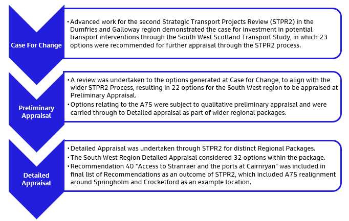
Southwest Scotland Transport Study; Initial Appraisal: Case for Change (2020)
Within STPR2, the following 11 ‘regions’ were established: Argyll and Bute, Ayrshire and Arran, Edinburgh and South East Scotland, Forth Valley, Glasgow City Region, Highlands and Islands, North East Scotland, Scottish Borders, Shetland Islands, South West Scotland and Tay Cities.
The South West Scotland region, along with the Scottish Borders and North East Scotland regions, formed ‘advanced’ studies with their respective Cases for Change developed prior to the commencement of STPR2. The other remaining regions had their respective Cases for Change developed as part of the wider STPR2 process.
The South West Scotland Transport Study - Initial Appraisal: Case for Change (SWSTS) presents the results of the first stage of appraisal, undertaken in accordance with Scottish Transport appraisal Guidance (STAG). The SWSTS established the Case for Change and identified a range of multi-modal improvements to road, rail, public transport and active travel on key strategic corridors in the South West of Scotland, including those served by the A75 and A77 trunk roads, with a key focus being on access to the ports at Cairnryan.
This SWSTS undertook a detailed data analysis and a stakeholder engagement programme to establish the evidence base for problems and opportunities linked to transport on key corridors across the South West of Scotland. From this, Regional Transport Planning Objectives (TPOs) were developed to guide the ongoing development of solutions. Initial option generation, sifting and development was undertaken to identify a short list of options to be taken through Preliminary and Detailed Appraisal to be considered as part of STPR2.
An initial long list of over 650 individual options for improving transport in the region were identified through review of previous studies, public and stakeholder engagement and data analysis. Initial sifting considered geographic coverage and location of options, and whether they were within the agreed scope, as well as removal of duplicates to reduce the number of options remaining to approximately 210. These options were then broadly grouped by theme and corridor to result in 56 options to be considered.
Outcomes from the high-level appraisal demonstrated that each of the options had the potential to meet the Regional TPOs. However, a process of further option sifting was undertaken based on the likely impacts on implementability criteria, which considers feasibility, deliverability and public acceptability. Through further consolidation/packaging of similar options by route and mode, a final list of 23 options was subsequently identified.
As the South West Scotland region formed an ‘advanced region’ within STPR2, with the Case for Change developed prior to the commencement of STPR2 itself, the approach to option sifting differed slightly from that undertaken in STPR2 for the other regions. Therefore, to ensure consistency for the remainder of the STPR2 process, the advanced region option sifting exercises were reviewed to re-assess their options long lists by applying the STPR2 option sifting methodology. The updated results for the advanced regions were fed into the subsequent appraisal stages in parallel with the eight other regions. Ultimately, the updated option sifting exercise for the South West Scotland region using the STPR2 sifting methodology identified a total of 22 options that were taken forward for more detailed development and appraisal through the next stage of the STPR2 process.
The following options that were taken forward to the next stages of appraisal in STPR2 as detailed further below, are considered relevant to this scheme:
- Development of the Strategic Active Travel Network: Package of measures to develop the Strategic Active Travel Network in the South West of Scotland to better connect communities to key destinations, including cycle paths parallel to trunk roads and improvements to the National Cycle Network
- Development of the Timber Transport Network: Package of measures to support the transport of timber freight by road, rail and sea in the South West of Scotland.
- A75 Capacity Enhancements: Development of capacity enhancement measures on the A75, such as partial dualling, town/village bypasses and improved overtaking opportunities.
- A75 Safety Measures: Implementation of targeted measures, such as improvements to road geometry, bends and junction improvements to improve safety on the A75. Package will also include consideration of safety camera deployments through the Scottish Safety Camera Programme annual site prioritisation exercise.
Preliminary and Detailed Appraisal
Preliminary Appraisal Outcomes
Prior to preliminary appraisal, options generated at Case for Change were assigned to groupings, as there were many options that shared common traits across the regions and many options which in isolation would not deliver the strategic improvements the STPR2 is seeking to deliver. The options generated above for South West Scotland were assigned to applicable groupings and were subject to qualitative preliminary appraisal.
The main purpose of the Preliminary Appraisal was to capture the likely impacts of groupings and any key dependencies, with more detailed quantitative assessment to be undertaken at the Detailed Appraisal phase.
Decisions on whether or not to take Groupings forward from Preliminary to Detailed Appraisal were made based on overall performance against the TPOs, STAG criteria, and deliverability criteria, with consideration of alignment with established policy directives, Impact Assessments and performance against Transport Behaviour Scenarios.
The Grouping for “Improve Routes to Major Ports and Airports” captured options relating to the A75 capacity enhancements and safety measures, subsequently linking to Recommendation 40 of STPR2 “Access to Stranraer and the ports at Cairnryan”.
Detailed Appraisal – South West Region Recommendation 40
The grouping and interventions identified to be taken forward from Preliminary Appraisal were developed into eleven regional packages to be assessed at Detailed Appraisal stage. Groupings made up of location-specific interventions were assigned directly to regions based on the location of the component interventions, ensuring that region-specific problems and opportunities are addressed.
Detailed Appraisal Summary Tables (AST) were created for each region, with the South West Scotland Region AST including 31 Regional Recommendations to be considered. This included Recommendation 40 “Access to Stranraer and the ports at Cairnryan”, which was also included in the final list of 45 recommendations that emerged from STPR2.
STPR2 Recommendation 40 recommends that safety, resilience and reliability improvements are made on the A75 and A77 strategic road corridors, in turn supporting placemaking opportunities. STPR2 envisages that this could include, but is not limited to; improving junctions, enhancing overtaking opportunities with WS2+1 or climbing lanes at appropriate locations where slow moving traffic leads to risky overtaking manoeuvres, and widening or realigning carriageways to alleviate ‘pinch points’ such as narrow structures or at stretches of older standard single carriageway. STPR2 also notes examples of locations of improvement schemes to include A75 realignment around Springholm and Crocketford.
The recommendation is noted as meeting the key STPR2 objectives relating to Sustainable Inclusive Growth and Safety, Reliability and Resilience, as well as the Health, Safety and Wellbeing, Economy, and Equality and Accessibility STAG criteria. Recommendation 40 aligns with wider strategy and policy including the NPF4 National Development site at Stranraer Gateway, the Borderlands Inclusive Growth Deal and the Dumfries and Galloway Local Development Plan 2, which sets out plans for regeneration of the waterfront at Stranraer.
Transport Improvement Study, A75 Gretna – Stranraer A77 Ayr – Stranraer, Strategic and Economic Impacts Report (2023)
Following the findings of the UCR, SWSTS and STPR2, Dumfries and Galloway, South Ayrshire and Mid & East Antrim Borough Councils commissioned the Transport Improvement Study A75 Gretna – Stranraer A77 Ayr – Stranraer , which consisted of a Strategic and Economic Impacts Report and an Economic Activity and Location Impacts Report.
The Economic Activity and Location Impacts Report (EALI) presents information on the transport and socio-economic baseline conditions, as well as information on business and stakeholder consultation, in the South West of Scotland. Whilst it also assesses the geographic distribution of economic benefits at both a regional and national level, it does not identify any additional economic impacts to those covered in the Strategic and Economic Impacts Report. Further to this, economic analysis presented in the EALI covers the impacts of a ‘do maximum’ option, involving full dualling of both the A77 and A75 (as well as other additional transport improvements in the region). For these reasons the findings of the EALI have not been detailed in this report.
The Strategic and Economic Impacts Report reports the details of assessment of a number of transport infrastructure improvements throughout the region and quantifies the anticipated economic benefits. The report examines seven different improvement packages, each with variations of bypass and dualling options along the A75 and A77 trunk roads, junction improvements along both trunk roads and rail improvements throughout the region. The report provides analysis of the potential economic benefits, including transport user savings, accident reductions, wider economic impacts and land-use changes, concluding with an overall Present Value of Benefits (PVB) for all packages.
The report utilised the Transport Model for Scotland (TMfS) to provide a broad representation of transport supply and estimates of transport demand within the region, using the TMfS18 Do Minimum as the reference case and Without Policy scenarios for 2030 and 2045 forecast years, as the comparators for intervention assessment. The sections within the assessment corridor of the 2030 and 2045 networks were interrogated, with coding changes also made to the baseline models to reflect real-world conditions.
Of the seven improvement packages assessed, Package 5 “Bypasses of key towns and junction improvements along the A75” included providing bypasses of Springholm and Crocketford alongside other targeted road enhancement measures such as improvements to junctions on the A75 and provision of further capacity on existing bypasses, and rail improvements throughout the region. It should be noted the bypasses of Springholm and Crocketford were assumed to be dual carriageway within this package.
The introduction of this package was anticipated to lead to significant Transport Economic Efficiency (TEE) improvements with traffic experiencing less delay, travelling at faster speeds and therefore experiencing lower journey times. The introduction of bypasses at Springholm and Crocketford and other enhancement measures along the A75 resulted in approximately £146 million in TEE benefits, the majority of these benefits accruing to business journeys. Further benefits were identified through journey time savings for bus users, albeit of a significantly smaller magnitude. In addition, accidents savings of approximately £26 million were estimated. These were approximately £5 million more than the savings resulting from an equivalent package of improvements to the A77, with the report highlighting that A75 improvements should be priority.
The improvements also result in significant Wider Economic Impacts (WEI) of approximately £44 million, seen through major positive labour supply and economic output impacts. These impacts are concentrated in the Dumfries and Galloway council area with slightly lower benefits elsewhere. Significant accessibility improvements were also anticipated, which for those without access to a car is largely focussed in Dumfries, whereas for those with access to a car these benefits are seen throughout the region and on several sections of the A75.
The report further assesses dynamic agglomeration effects, changes seen as a result of business relocation to areas of denser economic activity, which tend to be more productive than areas of less dense economic activity. All packages see an overall positive dynamic agglomeration effect, suggesting that there will be an increase in employment growth and therefore economic activity in the region. Whilst dynamic agglomeration impacts for packages consisting of bypasses without dualling were not calculated, estimates were made based on labour supply and static agglomeration impacts. For the A75 bypasses and measures package this impact was predicted to be negative in South Ayrshire, with an overall positive impact across South Ayrshire and Dumfries and Galloway. This means that whilst the overall growth in economic activity in the region is positive, the A75 bypass measures are likely to draw employment growth away from South Ayrshire into Dumfries and Galloway.
The report measures the wider spatial and social context of public expenditure, measuring benefits to households and other agents from changes to accessibility as a result of transport improvements and land use change. This analysis is often not covered by conventional economic appraisals and as such has been calculated using ULTrA software. This is a novel approach that applies welfare-based cost-benefit analysis to the zonal variables of the Transport and Economic Land-use Model of Scotland. For the A75 bypasses package the calculated impact was estimated to be approximately £752 million. It should be noted that this report considered traditional TEE and WEI analysis in conjunction with this new approach. The reported benefits associated with each should not be taken together, as ULTrA should represent an alternative method of calculating transport infrastructure methods.
Given the importance of the A75 as a key connector between the north of England and Northern Ireland it is expected that interventions that improve accessibility throughout the region would also have significant impacts in England and Northern Ireland. The Strategic and Economic Impacts report, however, does not include cross border impacts within its scope and does not report on the expected Dynamic Economic Impacts in England and Northern Ireland.
Overall, accounting for all economic impacts the report finds that when comparing bypass interventions on the A77 and A75, those on the A75 bring significantly higher benefits. Overall, the Present Value Benefits of the A75 bypasses and measures package were estimated to be approximately £1.1 billion, according to the report and noting there may be an over estimation due to the use of both traditional analysis and ULTrA methodology.
Given the detail and certainty required to develop accurate costs estimates for these interventions, the report does not provide any indication of potential capital and operational expenditure. This means that no Net Present Value or Benefit to Cost Ratio can be determined for the improvement packages.
The economic assessment of any options or packages identified as part of the A75 Springholm and Crocketford Improvements will, therefore, be more specific and targeted to the villages and immediate surrounding area. This will allow for detailed economic analysis and cost estimates to be developed for the specific options identified and an indicative Benefit to Cost Ratio determined.
Problems and Opportunities
The evidence-based assessments undertaken through STPR2, described earlier in this section, led to the identification of a number of problems and opportunities in the South West Scotland region. Those which are of direct relevance to the A75 Springholm and Crocketford Improvements are summarised below, with the evidence base utilised at the time also identified. Commentary on the evidence base is provided to assist in the identification of gaps for future analysis, further detailed in the Gap Identification section of this report, to reconfirm these problems are still relevant at later stages of assessment, i.e. during Outline Business Case preparation. This, therefore, is intended to bridge the gap between the work undertaken at STPR2 for the higher level strategic case and the specific assessment work to be undertaken for the Design Manual for Roads and Bridges (DMRB) Stage 1 Scheme Assessment Report for the proposed scheme.
Data supporting the listed problems and opportunities was largely collected at the Case for Change stage through the SWSTS and subsequently utilised in the assessment of options through the STPR2 preliminary and detailed appraisal stages.
Roads Based Problems
Road Standard / Vehicle Platooning / Route Consistency
This problem relates to a range of issues with regards to the road network which impact upon performance and how the network is perceived locally and by those in other parts of Scotland and the UK. Traffic platoons can form regularly on the A75, with some a result of the high volume of HGV traffic and the lack of overtaking opportunities on these routes, owing to its current standard. This leads to a slower overall road speed, increasing driver frustration and a higher propensity for severe accidents (refer to the problem below for further detail on journey time issues noted in the SWSTS). The impacts of traffic, including HGVs, travelling through settlements located on or adjacent to the strategic road network have been identified as having an environmental impact in the form of air quality, noise, vibration and severance impacts on communities in the South West of Scotland.
Evidence Base
The SWSTS presents Annual Average Daily Traffic (AADT) Data from 2017, sourced from Transport Scotland and Department for Transport count sites. The analysis also provides a comparison to volumes in 2008. The data notes two-way AADT of around 9,000 vehicles per day at count sites near the villages of Springholm and Crocketford, with an increase of around 5% evident from 2008 to 2017.
Roadside interviews (RSI) were undertaken in 2016 to provide more detailed information about traffic in the study area, including vehicle composition. The RSI site at Lowthertown on the A75 between Annan and Gretna had the highest proportion of HGVs, accounting for 19% of the vehicles. The proportion of HGVs recorded at the A75 East of Castle Douglas site (12%) was lower than that recorded at Lowthertown, likely reflecting the role of Dumfries as a key origin and destination of freight. The RSI data also confirmed a high proportion of traffic on the A75 originates in Northern Ireland.
Specialised Goods Vehicle Counts (SGVC) were undertaken in Dumfries and Ayr to support a greater understanding of the freight-based activity in the area and further highlight the importance of the A75 in supporting the role and operation of the ports at Cairnryan. The A75 SGVC site was located at the A75/A76 roundabout in Dumfries and noted 3,700 freight vehicles over the survey period, of which 35% was port related. Based on the SGVC observations and valuations of the type of goods being transported, approximately £26 million worth of goods per day is estimated to use the A75 East of Dumfries and £20 million on the A75 West of Dumfries.
The SWSTS did not specifically quantify the number and length of overtaking opportunities (either dual carriageway or WS2+1 provision) on the A75. This has been reviewed as part of the background context for this report.
Slow Vehicular Journey Times and Journey Time Competitiveness
The traffic mix and the standard of road on the A75 can contribute to slower journey times compared to other comparable strategic routes and could be a factor in affecting journey route choice, potentially undermining the competitive position of the ports at Cairnryan.
Evidence Base
Journey Time data used in the SWSTS was obtained from INRIX for 2017. To assess average speeds on the strategic road network and compare these against other key corridors in Scotland, an analysis of journey time data was undertaken. This examined typical journey times and speeds along several key strategic corridors in Scotland during the interpeak period.
The analysis showed a typical journey time of 124 minutes and speed of 45mph on the A75 (over 95 miles), which is well below some of the other strategic routes in Scotland, including the A9 between Perth and Inverness and the A90 between Perth and Aberdeen which were identified in the SWSTS as both having typical speeds of around 51mph for an equivalent distance.
Analysis also considered typical average road speeds for the ‘last 100 miles’ of journeys to Irish Sea ports: Cairnryan (from Gretna) - 44 mph; Heysham (from M6 north) - 55 mph; Liverpool Stena Terminal (from M6 north) - 51 mph; and Holyhead (from M56/M6) - 58 mph. On this basis, travelling the last 100 miles to Cairnryan (from Gretna) takes up to 30 minutes longer than the equivalent trip to Holyhead.
Accident Rates and Severity
The issues around road standard are thought to lead to more severe accidents, and there is a perception of high number of road traffic accidents on the A75 and in the South West of Scotland, with SWSTS evidence noting higher KSI accidents at the time of analysis.
Evidence Base
The SWSTS and STPR2 present accident data analysis for 2012-2016 inclusive, comparing the A75 to rates for the strategic routes in South West Scotland, namely the A77, A76 and A701 to national accident rates. This highlighted that while there is a perception that there are a high number of accidents on the strategic roads within the study area, the observed accident rate per million vehicle kilometres travelled on the full A75 corridor is lower than the equivalent national rate. However, the proportion of killed and seriously injured accidents is higher than the equivalent national values across all routes. This indicates that although accidents may be less likely to occur, when they do occur there is a greater risk of these being more serious in nature.
Road Maintenance
There is a perception that the condition of the A75 is poor, which can have implications for safety and can contribute to longer and unreliable journey times. In comparison to the Scottish average, a higher proportion of roads in the SWSTS assessment corridor either have some deterioration and require investigation or are in poor overall condition and require planned maintenance soon.
Evidence Base
The SWSTS used evidence from the Scottish Road Maintenance Condition Survey from 2018 to demonstrate that a higher proportion of ‘all roads’ in the Dumfries and Galloway region were “rated as Red or Amber i.e. likely to require investigation, compared to national figures, which may support the perception of limited roads maintenance in the region”.
Traffic Levels in and around Dumfries
The A76 and A701 trunk roads both intersect the A75 at the Dumfries bypass, with traffic delays in and around the town centre highlighted as having an impact on the ability of traffic to move around the town. This affects journey times for traffic on the trunk road routes, increases carbon emissions and negatively impacts air quality.
Evidence Base
The SWSTS presents journey time information from 2017 that highlights there is a high degree of journey time variability in the peak periods on the Dumfries bypass and in the town suggesting a higher volume of traffic around these times being a potential factor in congestion.
Diversionary Routes
When a diversionary route is required due to an incident on the A75, the alternative route generally requires travel on local roads through rural communities, with the potential to substantially increase journey distance and time. For businesses in particular, this can increase costs associated with fuel and staff and add to the wear and tear to vehicles that impacts on operations. This can lead to a ‘loss of faith’ in the reliability of port access.
Evidence Base
The SWSTS undertook a review of the diversionary routes for closures on the A75 Trunk Road and established that the longest recommended diversion route can add up to 2 hours and 20 minutes to the journey times. This was a key point of dissatisfaction expressed in the stakeholder engagement undertaken for the SWSTS, with 58% of those living in the A75 corridor being dissatisfied with the diversionary routes.
HGV Parking / Rest Areas
There is a lack of formal HGV parking / rest areas. During consultation as part of the SWSTS, concerns were also raised regarding HGVs stopping in local villages, particularly prevalent during incidents on the road network.
Evidence Base
Survey work undertaken for the SWSTS to better understand freight movements in the region highlighted that while layby parking supply on the A75 was generally seen as sufficient in number, there are few formal rest area opportunities or locations with eating, toilet or rest facilities. Issues with vehicles stopping in local villages was noted as a result of timber vehicles having defined routes, so where incidents result in a road closure, vehicles are reported as parking in villages causing safety and amenity issues for local communities.
Electric Vehicle (EV) Infrastructure
There are limited EV charging points in South West Scotland, which may constrain uptake in EVs, especially given the distances involved in making strategic trips in the region.
Evidence Base
The SWSTS utilised ChargePlace Scotland to identify locations of EV infrastructure in the region, highlighting the few locations of chargers on the network, including along the A75 corridor. Analysis at the time indicated that the A75 corridor had more charging points than the A77 corridor for example, but that there were still relatively long gaps in the charging network.
Active Travel Based Problems
Active Travel Facilities and Links to Key Interchanges
There is a lack of safe, off road active travel facilities alongside trunk road route, including the A75, in the South West Scotland region, offering limited accessibility across the area and to bus and railway stations for interchange opportunities.
Evidence Base
The SWSTS presents information on active travel facilities in the region from a variety of sources including mapping and plans from Sustrans and Dumfries and Galloway Council. The SWSTS highlights National Cycle Network (NCN) routes, including the NCN Route 7, which runs along the Old Military Road to the south of the A75 through the section between Castle Douglas and Dumfries. The SWSTS did not have baseline active travel levels available, however, it draws upon the findings of previous work undertaken in Dumfries and Galloway region and stakeholder feedback to identify the barriers and constraints to active travel, such as lack of dedicated cycle and pedestrian facilities or active travel access to public transport being noted in Dumfries and Galloway Active Street Review.
Public Transport Based Problems
Public Transport Service Integration
There is a lack of integration between bus services, as well as with other public transport modes including rail and ferry. This can result in extended wait times for passengers that increases journey times and impacts accessibility to employment, healthcare and higher education opportunities for those without access to a car.
Evidence Base
The SWSTS demonstrated via some specific case studies that there is a lack of integration between connecting bus services, bus and rail and bus and ferry services. For example, the Stagecoach 500 service no longer runs between Carlisle and Stranraer and requires a connection to Service 79 in Dumfries, with the waiting times ranging between 20 minutes and 2 hours adding significant time to public transport journey.
Public Transport Connectivity and Frequency
Public transport coverage across the South West Scotland area varies greatly by location. Rural areas face challenges with connectivity, potentially limiting access to employment opportunities, healthcare and further and higher education. With an ageing population, the ability to access healthcare for example is becoming increasingly important. Limited access to healthcare from rural locations could place a financial burden on the Health Service and the communities themselves to ensure suitable access.
Evidence Base
The SWSTS undertook detailed analysis to establish the level of connectivity by public transport from 36 localities in the assessment corridor (identified by SWSTS) to key destinations including employment opportunities, healthcare and further and higher education. For employment, analysis undertaken for the SWSTS found that Dumfries and the south east of the region close to the border is relatively well connected to employment by public transport. Areas to the south of the A75 corridor face the most challenge with connectivity in terms of access to larger towns and cities. The analysis also highlighted that connectivity between key towns in the assessment corridor and rural towns and villages can be particularly problematic after 21:00 due to reduced frequency of bus services. In terms of public transport access to the ports at Cairnryan, analysis in SWSTS show the shortest public transport journey times occur between 08:00 and 16:00.
Opportunities
As well as the gathering of evidence and consultation feedback to understand the problems in the region, the SWSTS has identified and presented some key opportunities that transport improvements in the South West of Scotland could support and help to realise. Opportunities tend to be presented at a higher level than the problems, and therefore a specific evidence base is not attributed. The main themes in terms of opportunities noted are therefore outlined below.
The SWSTS presented opportunities that largely relate to promoting sustainable economic growth. One specific opportunity is encouraging inward investment through delivering accessibility improvements that can help stimulate investment, with associated positive impacts on the economy. The SWSTS also noted Growth Deals as an opportunity. Both Ayrshire and the Borderlands present opportunities to drive economic development across the region and will require support by appropriate consideration of transport infrastructure improvements to maximise potential. A further opportunity relates to how transport improvements can assist in realising specific development opportunities. A number of high-profile development opportunities have been identified in the region, including the redevelopment of Stranraer Waterfront, which could be realised if improved transport infrastructure and increased transport accessibility is also enabled.
Another opportunity is supporting tourism in the South West of Scotland, with it being noted that the area has a strong tourism offering with including the likes of 7Stanes mountain bike sites, the Southern Upland Way footpath route, Galloway Forest Park, the UNESCO Biosphere and numerous castles, golf courses and museums. However, concerns were raised during consultation that inadequate transport connections were inhibiting this potential, with poor connectivity including long journey times within and to the region considered a major deterrent to attracting visitors to the area. It is considered that improved transport connectivity, including public transport and active travel, and reduced journey times could attract a greater number of tourists to the region. It was also felt that longer term economic benefits and local employment opportunities could be generated from an increase in active travel tourism that would support local communities.
Increased electric vehicle use was also identified as an opportunity. An increase in the availability of charging infrastructure has the potential to encourage more sustainable travel throughout the region. The SWSTS notes this could have subsequent environmental benefits as a result of fewer emissions.