Landslides
Overview
Scotland's stunning scenery sometimes has its drawbacks in inclement weather. The country's high mountains and steep valleys are prone to landslides under sustained, heavy rainfall. Landslides can have adverse affects on Scotland's trunk roads, so Transport Scotland have implemented safety and efficiency measures to mitigate their impact.
What is a landslide?
A landslide is defined as a movement of a mass of rock, earth or debris down a slope. Landslides can be divided into the following types of movement: falls, topples, slides and flows. The type of material involved in the movement can include rock, debris or earth.
Most events with a significant impact on Scottish trunk roads in recent years have been relatively fast-moving, shallow debris flows.
The weather has a significant influence on landslides, so we pay close attention to local weather warnings. Extended, heavy rainfall at places such as Rest and Be Thankful is likely to cause debris flow onto the trunk roads.
Further general information on landslides can be found on the websites of the British Geological Survey and Scottish Natural Heritage.
Mitigating the impact of landslides
Transport Scotland seeks to reduce the impact of landslides on trunk roads in several ways, including:
- monitoring landslide-prone slopes
- liaising with weather forecasters
- landslide patrols
- providing travel warnings, information and advice
- landslide risk reduction measures
We cannot prevent landslides from occurring, but we can manage the consquences effectively to reduce their impact on the trunk road network.
We published the Scottish Road Network Landslides Study in 2005, following severe road closures after landslides in the previous year. In 2009 we published an Implementation Report and we continue to study landslides in the country.
The study provides a picture of the potential future risk of landslides in Scotland that may impact on the trunk road network and evidence to help us plan and manage the risk.
Safe travel
Safety for all road users is one of our main priorities. If you are driving in areas known to be affected by landslides, you can follow these basic tips for staying safe:
- plan your journey in advance using the Traffic Scotland website
- check the weather forecast before you set off
- allow extra travel time
- be alert for water or debris on the road
- listen for travel bulletins and looking for roadside messages displayed on variable message signs
- avoid stopping on bridges or next to water courses in mountainous areas
- plan your stops in towns and villages rather than the open roadside
Known landslide areas
A82 Glen Righ
On 26 October 2014, after exceptionally heavy rain, a section of the A82 near Corrychurrachan Bridge was blocked by excessive water flows and debris from the adjacent hillside. White water carved three separate channels down the hillside and carried debris with it.
BEAR Scotland and the Forestry Commission cleared the road of debris by early afternoon on 27 October, preventing scouring of the wingwall of Corrychurrachan Bridge. The team also cleared the blocked culverts to allow continued drainage. The temporary traffic signals were removed the following week when a reduced water level allowed an inspection to prove that the bridge was still in tact.
Forestry Commission infrastructure, such as small bridges and driving tracks, were damaged significantly during the event.
Following the landslide event a debrief exercise was carried. The aim of a debrief exercise is to enable the responder organisations to reflect on the response and implement learning into future practices and processes. The debrief report can be viewed online.
A7 Terrona
Minor landslides on the A7 trunk road at Terrona caused disruption on the road in late 2006. In 2013, work began on rock armour revetments to mitigate the effects of landslides.
The landslides in 2006 occurred 9m from the eastern edge of the A7, making it a low-risk area with little expected impact on the road. Transport Scotland and BEAR continued to monitor the area nonetheless and identified that the area was still compromised. The mitigation measures of rock revetments were therefore built to reduce further erosion. It was completed in September 2013.
A702 Lamington
The A702at Lamington experience an embankment failure and eroison on the highway verge. Transport Scotland's operating company, BEAR Scotland, undertook emergency works to ensure that the road remained open.
About 75m of the road was damaged by surface water runoff from adjacent fields, exacerbated by vehicle overrun. The carriageway profile allowed surface water to run across the road, contributing to the destabilisation of the verge and embankment.
BEAR Scotland redesigned the road here. They used a steel track system to minimise damage to the neighbouring field and used rock armour to strengthen the embankment. This allowed for better drainage during heavy rainfall.
The completed embankment was covered in topsoil and seeded with grass. This returned it to its existing environment and provided defence against future erosion.
A82 Glen Gloy
The A82 at Glenfintaig, near Glen Gloy, experienced a landslide when a fallen tree detached some of the road verge and exposed the edge of the carriageway. The road is open and temporary signals will operate until repairs are complete.
Glenfintaig sits on the A82 between Fort William and Fort Augustus.
The landslide occurred during a storm when a tree fell and detached part of the road, leaving the verge side safety barrier suspended in mid-air.
The slide area is 13 metres wide, by 5 metres long and drops to a 1.8 metre sheer face below the carriageway edge.
After initial works to protect the slope, the road was reduced to single lane traffic, controlled by temporary signals.
As traffic flows are low, journey delays are minimal and these signals will only remain in place until a permanent scheme has been built.
During construction the road may be closed for short periods.
Initial works to stabilise the slope and safeguard road users included:
- Cut drainage grips and sand-bags placed to divert surface water run off away from the failure scar and protect the slope from further water ingress
- A new steel barrier to provide protection and prevent vehicles from going over the edge. This will keep vehicles away from the edge of the failure and minimise the load directly above the failure scar
- Controlled removal of an unstable tree adjacent to the failure that was leaning and causing stress to slope. The rootball has been left in-situ to provide support to the soil
- A protective waterproof membrane to protect sheer face of upper 2 metres
- Abnormally heavy loads have been re-directed to prevent excessive loadings above the failure
We continue to look for signs of movement, subsidence or cracking in the road surface, increases in the size of the failure zone, tension cracks and washout from the face of the slide area.
Design of the preferred option, a 300 metres offline realignment, remote from the edge of the gorge, is currently being progressed.
A835 Tarvie
On 6 October 2012, 3 landslips occurred on the embankment of the A835 at Tarvie, resulting in the road edge collapsing. The repair of the embankment was completed in July 2013.
Transport Scotland’s Operating Company assessed the situation and was instructed to carry out a drainage survey at the location.
The drainage investigation was carried out in November 2012 and this highlighted areas for improvement.
In addition a geotechnical engineer was commissioned to assess the slope failure and a report was submitted to Transport Scotland.
Drainage improvement works, including the installation of new filter drains, catchpits and gullies, and deepening of existing ditches were undertaken in mitigation as it was concluded that the inadequacy of the former drainage in the vicinity of the slip was a major contributory factor.
Embankment repair works included the provision of a below ground level drainage layer and installation of a culvert extension and headwall.
Road carriageway edge strengthening was also carried out.
Repair works were completed on 24 July 2013
A82 Loch Lochy
The retaining wall of the A82 at Loch Lochy was fully repaired in January 2013 after a collapsed occurred as a result of high winds and heavy rain.
Safety of the A82 at Loch Lochy, 1km north of the Letterfinlay Lodge Hotel, was compromised by a collapsed retaining wall.
Following bad weather, loch waves undermined foundations and dislodged the wall, in turn destroying the verge and exposing the carriageway.
The failure area was 20 metres long and 5 metres wide with a steep shelf below the foundation area.
As a safety measure, one lane of the A82 was temporarily closed and traffic lights directed drivers around the lane until repairs were complete.
Initial works were undertaken to stabilise the slope and safeguard road users.
Crushed rock (approximately 1x3 metres in size) was placed on the exposed embankment to protect against further damage to the verge of the A82.
After BT re-routed a fibre optic cable that ran through the area, the final repairs to the retaining wall were completed.
A83 Rest and Be Thankful
Transport Scotland are currently undertaking extensive work on the stretch of road by Rest and Be Thankful. You can read about the work on the A83 project page.
Landslide signage
Transport Scotland highlight the risks of landslide-prone areas using this sign.
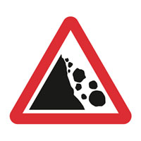
Although the Department for Transport Traffic Signs Manual indicates that this sign indicates the risk of falling rocks, it is used for all kinds of landslides, including debris flow.
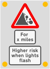
At Rest and Be Thankful on the A83 we have instigated the first ever use of 'Wig Wag' road signs for landslides. These warn road users when there is a higher risk of landslides than is normal. The sign will flash a warning when the risk is higher.
Like all warning signs this does not mean that the road is closed but acts as a warning to road users who must exercise caution when using the road.
If the wig wag signs are flashing, motorists should avoid stopping, particularly on bridges or next to watercourses but instead to proceed with increased caution.
Procedures for activating Wig Wag signs
 The risk of landslide occurrence along the A83 Rest and Be Thankful has been identified under the Scottish Road Network Landslide Study: Implementation.
As part of the management actions to mitigate the risk of landslides, trialling of Wig-Wags on an identified section of the A83 trunk road has been recommended to provide a warning to road users of the increased risk of landslide occurrence at times of heavy or persistent rainfall.
This procedure identifies the specific monitoring and operational requirements that need to be put in place as a result of a Heavy Rainfall Warning being issued for heavy or persistent rainfall along this particular section of route.
| Threshold Level | Stage | Actions |
|---|---|---|
| 25mm/24hr rolling threshold or 4mm/hr over any 3hour period (Agreed trigger values for Heavy Rainfall Warning) | 1 | Warning Phase
|
| 2 | Monitoring
|
|
| 3 | Wig-Wags Triggered
|
|
| 4 | This plan is linked to the existing OC Emergency Response Plan for a landslide occurrence. |
| Threshold Level | Stage | Actions |
|---|---|---|
| 25 mm/24hr rolling threshold or rain to fall at 4 mm/hr over any 3 hour period 6 hours after expiry of rainfall warning, the Wig Wags/VMS can be switched off. | 1 | Monitoring
|
| 2 | Wig Wags Switched Off
|
South West Landslide Action Plan
Action Plan and Programme
Our action plan has been developed taking into account the risk level determined by regular monitoring undertaken by our operating company. We have used this information, balanced with competing priorities across the trunk road network, to determine a delivery programme.
This programme features information on schemes with a risk level above ‘medium’, including up to date progress. Further information can be accessed for each scheme at the South West Monitoring Sites page.
Our programme may vary throughout the year due to unforeseen circumstances for example weather, emergency events and budget priorities, but we will update the programme to reflect any changes as they occur. It is difficult to predict what our budget priorities may be beyond this financial year, therefore the programme is indicative and subject to change.
| Scheme location/Name | Delivery dates for improvement works | What we are currently doing/Further details |
|---|---|---|
| A76 Blackwood (GA05) | 2024/2025 |
Monitoring of the slope is on-going at intervals not exceeding 6 months. Option selection and detailed design currently ongoing during 2024. |
| A76 Glenairlie (GA17) | 2024/2025 |
Monitoring of the slope is on-going at intervals not exceeding 6 months. Option selection and detailed design currently ongoing during 2024. |
| A77 Carlock Wall Rock Face (GA15) | 2024/2025 |
Monitoring of the slope is on-going. Improvement works design currently ongoing during 2024. |
| A77 Glengall (GA9) | 2024/2025 |
Monitoring of the slope is on-going at intervals not exceeding 6 months. Option selection and detailed design currently ongoing during 2024. |
| M80 Earnock Cut (GA01) | 2024/2025 |
Monitoring of the slope is on-going. Improvement works design currently ongoing during 2024. |
South West Monitoring Sites
Transport Scotland has monitoring requirements for particular areas of the network with earthworks present. In the South West unit, we currently have a total of 16 sites. Our operating company, Amey, conducts monitoring of these areas on our behalf in accordance with the methodology outlined in the Design Manual for Roads and Bridges. Site monitoring regime comprises: 3 sites that require 3-monthly monitoring, 10 sites that require 6-monthly monitoring, 3 sites requiring annual monitoring.
Sites recognised as having above medium risk and being considered for further remediation are summarised below:
A76 Blackwood (GA5)
The site is located along the A76 Dumfries – Kilmarnock Trunk Road at approximate National Grid Reference E290321, N588210. The A76 is a single carriageway, trending at this location broadly northwest - southeast. The trunk road in this area is constructed within a cut section bordering the carriageway to the east and supported on an embankment to the west.
It sits on an embankment approximately 5m above the River Nith which runs along the southwest of the road. The embankment rises at gradient of 1(v):1.5(h) from the toe of the embankment slope which is immediately adjacent to the river. At the crest of the embankment a verge of approximately 0.5m width separates the pavement from a safety barrier. To this east is a cut extending into the adjacent hills to the east. This site is subject to a slope stability monitoring regime at intervals not exceeding six months.
The embankment supporting the carriageway is displaying signs of distress with small areas of slip and terraces forming along a length of the embankment. The verge has settled locally with the adjacent barrier showing signs of distortion over approximately 50m length, brought about by ground movement. Remedial patching of the carriageway is evident at this location. Cracks in the northbound lane, outwith the patching, running parallel to the verge are likely to be associated with the instability of the embankment. The face of the embankment is covered by dense vegetation, shrubbery and mixed woodland. The presence of inclined tree trunks suggests that a creep or minor historic landslide has occurred. Drainage can be seen in the verge as grips perpendicular to the carriageway.
A76 Glenairlie (GA17)
The site is located on the A76 trunk road, approximately 4km south of Mennock and 3km north of Enterkinfoot. Glenairlie Bridge crosses the River Nith immediately north of the Glenairlie embankment section and connects the trunk road to the local roads on the west side of the river.
The scheme comprises a single carriageway trunk road located on sidelong ground sloping from northeast to southwest towards the River Nith. The ground to the south-west of the A76 comprises a river slope / embankment with a height in the region of 7m and an estimated gradient of 1(v):0.75(h), which is shallower towards the toe of the slope. A verge separates the A76 carriageway from the slope adjacent to the northbound lane, where a vehicle restraint system (VRS) is in place. The upper slope to the north-east of the A76 comprises sidelong ground which was noted to be in generally good condition. The face of the embankment is covered by dense vegetation, shrubbery and mixed woodland
A 45m section section of the A76 Glenairlie site at approximate National Grid Reference 283565,605640 has been identified as showing signs of slope instability from the asset monitoring inspections. This site is subject to a slope stability monitoring regime at intervals not exceeding six months. Signs of instability observed during the asset monitoring inspections include Vehicle Restraint System (VRS) verticality, exacerbated carriageway camber, surface water washout between the VRS posts, and bending of trees towards the River Nith at the toe of the slope.
A77 Carlock Wall Rock Face (GA15)
The site is located adjacent to the A77 trunk road network, at approximate National Grid Reference E209286, N577030. The A77 is a single carriageway, trending broadly north to south, constructed on sidelong ground falling steeply to Altikelly Burn located at the toe of the Altikelly Glen to the east and rising to the west to Carlock Hill. The rock slope face can be summarised as approximately 100m long, with height varying from 10 to 15m. adjacent to the northbound carriageway verge. It is covered in draped rock fall netting throughout the site extents, pinned at the crest of the rock slope face. This site is subject to a slope stability monitoring regime at intervals not exceeding six months.
The rock slope face is showing signs of deterioration. Rock fall debris has accumulated behind the rock netting at the rock face toe. Vegetation comprising mainly shrubs are prominent on the rock slope face. North of the site unfavourable bedding cleavage and fracture cleavage can be seen in exposed rock face adjacent to the turn off leading to Carlock House.
A77 Glengall (GA9)
The site of Glengall is located in a cut adjacent to the M77/A77 Glasgow – Stranraer Trunk Road, immediately southeast of Ayr at approximate National Grid References E235174, N618896. At this location, the A77 is a single carriageway. The cut can be broadly described as 7.5m to 15m high. Only the east side of the cut, adjacent to the southbound lane, has been recognised as at risk. At the crest of the cut east of the A77, arable farmland extends east on broadly flat ground. Extending from the crest of the cut west of the A77 is grassland bordered by a residential estate. The cut adjacent to the northbound lane shows no sign of instability. This site is subject to a slope stability monitoring regime at intervals not exceeding six months.
The cut adjacent to the southbound lane shows signs of instability including tension cracks, terracing at the crest of the cut and bulging at the toe. A boundary fence bordered by arable farmland is located at the top of the cut. The ground of this field, bordering the cut, was noted as partially saturated on all occasions during the geotechnical monitoring particularly towards the southern end of the site. An open drainage ditch runs along the top of the slope and a herringbone drainage system is present throughout the cut. A single tier of gabion baskets extend along the toe of the cut, adjacent to the southbound lane. The majority of these have tilted to some degree, but some have settled extensively in one localised area.
M80 Earnock Cut (GA1)
The site is located adjacent to the northbound carriageway of the M80 Glasgow – Stirling Trunk Road, at approximate National Grid Reference E262701, N667429. The M80 is a motorway, trending at this location broadly northeast - southwest. The site location is at a point where the M80 sits in a cut slope, running between a railway line and a residential development. The monitored slope is located adjacent to the northbound motorway lanes. The slope rises approximately 10m above the adjacent motorway lanes. This site is subject to a slope stability monitoring regime at intervals not exceeding six months.
Deterioration and instability of this slope is shown over a length of approximately 250m. The slope shows signs of distress with tension cracks developing and terrace forming in the top half of the slope. Bulging is evident throughout the slope mainly along the toe. Erosion channels can be seen throughout the slope suggesting historic drainage issues, confirmed by presence of herringbone drains along the length of the cut. Monitoring equipment is installed in two areas of the cut. The cut slope is covered partially by trees and vegetation which continues along the northern boundary of the site. It can be assumed that the existing vegetation contributes to the stability of the slope.
Sites recognised as having low or negligible risk have not been considered further but will continue to be monitored in accordance with the requirements outlined above. These sites comprise:
- A77 Bennane (GA06)
- A77 Carlock Hill (North of Altimeg Farm) (GA07)
- A77 Drumbo Kennels (GA10)
- A77 Holmston (GA11)
- A77 Mark Church (GA12)
- A77 Cairnryan (GA14)
- A77 North of Stena (GA16)
- A76 Enterkin Cottage (GA18)
- A77 Carlock Hill 2 (North of Carlock Cottage) (GA19)
- A78 Chriswell (GA21)