A83 improvements
Overview
The A83 is the gateway to Argyll, a vital road running from Campbeltown to Tarbet via the ferry port at Kennacraig.
A comprehensive route study, conducted by Jacobs, concluded that work needs to be done across the length of the road. Transport Scotland has developed a programme of improvement works that target the issues identified by the route study.
A major part of the project involves landslide prevention at Rest and Be Thankful, the highest point of the road. The rest of the work will involve speed control measures, road improvements and pedestrianisation.
Objectives
Transport Scotland aims to:
- reduce accident rates and severity on the A83
- improve pedestrian and cycling amenities in the settlements along the A83
- improve journey time reliability
- reduce the economic impact on the A83 Study area by reducing the frequency and duration of road closures caused by landslide
Programme of works
The A83 improvements programme may vary throughout the year due to unforeseen circumstances for example weather or emergency events, but we will update the programme to reflect any changes as they occur.
It is difficult to predict what our budget priorities may be beyond this financial year, therefore the programme beyond 2017/18 is indicative and subject to change.
This page features information on each scheme, including up to date progress and additional details.
| Scheme location/ Name | Work due to commence | Planned Completion | What we are currently doing | |
|---|---|---|---|---|
| Pedestrian Assessments | Ardrishaig | Complete | Complete | |
| Tarbet | Complete | |||
| Inveraray | Complete | |||
| Landslide Risk Reduction | A83 Cairndow | No work to date | 2017+ | Lowest Priority site - Continued monitoring of the slope |
| A83 Glen Kinglas | 2017 | 2017 | Negotiations on land entry | |
| A83 Loch Shira | Autumn 2013 | 2015 | Phase I complete, monitoring continuing | |
| Rest and Be Thankful ("The Red Option") | Debris netting All Phases | Complete | Construction of debris netting complete. | |
| Woodland Planting | 2018 | 2020+ | Design and Planning stage with Forestry Commission. | |
| Slope Erosion Measures | Autumn 2013 | Spring 2015 | Works at channel below A83 complete. Continue to monitor other channels below A83 | |
| Slope Monitoring Improvements | Complete | Additional monitoring equipment has been procured and installed. | ||
| Landslide mitigation | 2017 | Spring 2018 | Catch-pits at high frequency channels at Phases 5, 7 and 9 under construction | |
| Road Improvements | Dunderave (Resurfacing) Phase 1 | Complete | Complete | |
| Dunderave (Resurfacing) Phase 2 | 2017 | Ardganavan/Drishaig scheme in programme for delivery in 2017 | ||
| Erines | Unfunded scheme | |||
| Barmore Road, Tarbert | Complete | The feasibility report on options is currently being finalised. | ||
| Strone Point | Autumn 2017 | Summer 2018 | Awaiting construction programme | |
| Speed Control Measures | Ardrishaig | Complete | Report has been compiled and recommendations are being taken forward by Transport Scotland. | |
| Minard | Complete | |||
| Lochgair | Complete | |||
Taskforce
The A83 taskforce was set up in August 2012 to:
- oversee delivery of actions to construct an emergency division route
- oversee delivery of wider study into the permanent risk reduction measure for landslides at this area
- ensure communications to wider stakeholders and ensure views of the wider stakeholder group are taken into account in the study
- consider the actions from the A83 Trunk Road Route Study and agree the next action
Below are the minutes and presentations from taskforce meetings since its inception.
Taskforce minutes
- 5 June 2019
- 15 November 2018
- 6 March 2018
- 24 October 2017
- 14 March 2017
- 7 September 2016
- 25 January 2016
- 7 July 2015
- 14 January 2015
- 10 June 2014
- 18 March 2014
- 4 September 2013
- 25 February 2013
- 14 December 2012
- 15 October 2012
- 15 August 2012
Taskforce information
- 7 September 2016 - Presentation
- 25 January 2016 – Presentation
- 7 July 2015 - Review - Supporting Information
- 7 July 2015 – Review - Frequently Asked Questions
- 7 July 2015 - Presentation
- 14 January 2015 - Presentation
- 10 June 2014 - Presentation
- February Newsletter
- August newsletter
- November newsletter
- January newsletter
- A83 Rest and Be Thankful - Military Road V Forest Track Report
Diagrams of slope failures and mitigation works
- Location plan of slope failures and mitigation works
- Wig-wag Activation Flowchart
- Wig-wag Activation Procedure
- A Technical and Perceptual Evaluation of Wig-Wag signs at the A83 Rest and be Thankful
- Contingency Planning Workshop – Debrief report
- A83 Landslide Events 28 Oct 2014 - Debrief Report
- A83 Landslide Events 28 Oct 2014 - Debrief Report - BEAR SCOTLAND Action Plan
Kennacraig and Campbeltown trunking
The A83 between Campbeltown and Kennacraig is a 51km stretch of single carriageway which carries about 2500 vehicles a day.
In August 2013, Scotland's First Minister announced that the A83 between Campbeltown and Kennacraig would be trunked. Transport officials are taking forward the formal trunking process and have opened discussions with Argyll and Bute Council.
Landslides
Many sections along the A83 are high-risk areas for potential landslides. Alongside significant work at Rest and Be Thankful, the Route Study identified three key areas for landslide protection work. In Autumn 2013 Transport Scotland instructed BEAR Scotland to produce detailed report into each of the following known landslide areas.
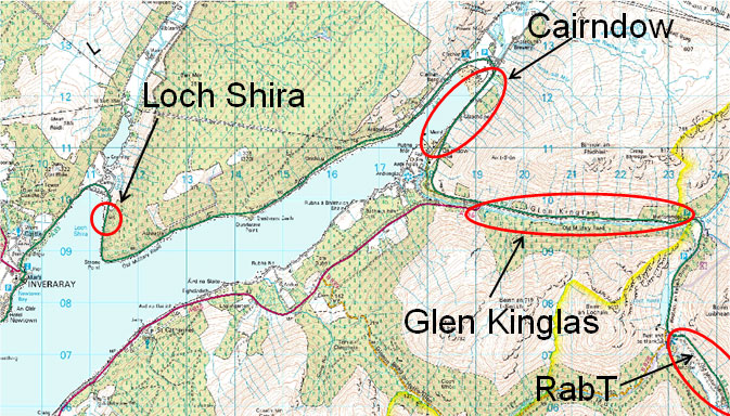
Loch Shira
In the mid-70s, a major landslide severely impacted the trunk road passing by Loch Shira. Since then, the slopes above the road on the eastern shore have been a source of concern.
In 1994, contracts were awarded to cut back the slope, install cut-off drains and the rockfill blanket. Ongoing slope movements, however, have led to signs of distress in these installations. The rock blanket and cut-off drains are now at the end of their useable life.
A number of options to replace them have been investigated. The preferred options are:
- Phase 1 - Installation of a new flexible, on-slope drainage system.
- Phase 2 - Construction of a new, improved rock blanket that includes deep, counterfort drains and carriageway drainage improvements.
Glen Kinglas
The Glen Kinglas study area is located between Butterbridge in the east and the settlement of Cairndow in the west. It is approximately 5.5km long and contains 32 channels that flow perpendicular to the Trunk Road. Typically events in Glen Kinglas are less dramatic that those experienced at the Rest and Be Thankful.
A number of potential risk reduction methods were considered during the assessment process, including:
- forestry planting
- enlarging and re-aligning existing culverts and associated ditches
- flexible (steel) debris barrier
- catch pits
- linear catch ditches with associated bunds
The preferred option is a combination of linear catch ditches and bunds. This could take the form of a an earthworks ditch and associated bund, which will be in t he region of 1.5m to 2.5m high.
Cairndow
The Cairndow study area is situated immediately north of the hamlet of Cairndow. A comprehensive desk study and site walkover survey were conducted to identify potential hazards and assess factors that influence the likelihood and severity of a potential landslide. These factors include, but are not limited to:
- slope geomorphology
- topography
- drainage
- vegetation
- land use
- probable ground model
- history of instability
Additional elements contributing to road user exposure were also considered, including parking spaces and the suitability of existing infrastructure.
A review of the site observation and desk study information determined the primary hazard to be from shallow landslide failures and channelised debris flows, the likelihood and severity of which vary throughout the route.
The study of the A83 concluded that the Cairndow study area is the lowest risk of the three highlighted landslide areas.
Minor upgrades
The A83 improvements project consists of many localised projects along the length of the road, according to issues identified in the route study.
Strone Point
Strone Point is a tight corner on the A83 outside Inveraray. £1.3 million of the A83 budget will go towards refining this section of the road.
The scheme will involve:
- realigning the carriageway and cutting back the rock slope to improve visibility for drivers
- widening the road to present-day standards
- upgrading the the drainage systems to improve road safety in wet conditions
- erecting a new road safety barrier and bike guard
- new road markings
- improved signing
These plans have been designed to stop any encroachment on the Loch Fyne SSSI, moving the road inwards instead of onto the loch.
Dunderave
The route study recommended improving the road around Dunderave, covering 5km of the A83 between Ardgenavan and Dunderave castle. The works will include:
- improvement to carriageway condition
- localised widening
- drainage
- safety barrier improvements
This scheme is being progressed in three phases so it can begin sooner. Phase 1 will improve the condition of the carriageway and, where possible, will also aim to incorporate localised road widening.
Barmore Road, Tarbert
One of the Route Study's recommendations involved widening the narrow section of Barmore Road in Tarbert.
Schemes in residential areas, however, come with several extra considerations. Alongside the widening project, the study also anticipated improvements to the footways, road markings and traffic signage. We have completed a survey of the area and preliminary design to give us the information we need to complete a feasibility assessment of this location. Our Operating Company, Bear Scotland are in the process of finalising the feasibility report on options at this location.
Layby review
We have progressed a review of the layby provision on the A83 Trunk Road to investigate and review the condition of all existing laybys on the route. Investigations are currently ongoing and as we progress with this study, we will update our programme of works to reflect the outcomes of the study.
Pedestrians
The A83 Route Study highlighted possible pedestrian measures at the following points along the road:
- Ardrishaig
- Inveraray
- Tarbert
These areas were highlighted after consulting local communities, who drew attention to areas that had been ignored in previous studies. We have commissioned Jacobs to undertake further studies in these areas.
Assessment of pedestrian facilities, and particularly pedestrian crossings, requires consideration of a range of elements to establish its potential benefits. We consider each location based on the site and its constraints, but the types of things which could be covered include:
- Where pedestrians currently cross the road. If there is a single obvious route or 'desire line', this would be a possible place to locate a crossing. Where there are multiple desire lines it may reduce the suitability of a crossing as people are more likely to cross without the use of a crossing where there is a quicker route.
- Number of accidents in the area, particularly involving pedestrians. The accident history influences the decisions for pedestrian facilities, as we need to make sure that implementing a new crossing does not create a new hazard on the route.
- Traffic speeds. Where there are high speeds, it is unlikely that a pedestrian crossing would be considered a safe option.
- Volume of pedestrians crossing the road. We need to balance many different elements for this aspect. As trunk roads are considered strategic routes, keeping journey times and delays to a minimum is an important factor to both Transport Scotland and road users. The continued maintenance and initial cost of installation needs to be justified by a level of people that would use the crossing.
- Pedestrian delay times. We look at the amount of delay that pedestrians crossing the road experience. If this is significant, then a crossing may be considered as an option.
A83 Route Study
The A83 Route Study was undertaken to identify and appraise potential options to minimise the effects of road closures with the objectives of:
- Reducing the impact on journey times by reducing the frequency and duration of road closures caused by landslides, and:
- Reducing the economic impact to the A83 Study area by reducing the frequency and duration of road closures caused by landslides.
The final A83 Route Study report and associated consultation feedback paper were published on 22 February 2013.
Part A examines the landslide issues at the Rest and Be Thankful. It identifies and appraises potential options to minimise the effects of road closures.
Part B examines a range of trunk road issues along the length of the A83 Trunk Road between Tarbet and Kennacraig such as investigating the feasibility of removing traffic pinch points and improve pedestrian safety in villages.
- A83 Route Study - services brief
- A83 Route Study FAQs
- Stakeholder Consultation Workshop: Summary of Discussion
Main report
- A83 Trunk Road Route Study Report Part A - Rest and Be Thankful
- A83 Trunk Road Route Study Report Part A - Appendix A - Available on request by email
- A83 Trunk Road Route Study Report Part A - Appendices B-G
- A83 Trunk Road Route Study Report Part B - Tarbet - Kennacraig
- A83 Trunk Road Route Study Report - Consultation Response
Summary report
TRL/Transport Scotland reports
This joint TRL and Transport Scotland report examines the merits of a number of ecological and related landslide mitigation options for the southwest facing slopes of Beinn Luibhead in Glen Coe above the A83 trunk road. The use of explosives and issues related to livestock and vegetation planting are reviewed.