Project Corridor Options - Access to Argyll and Bute (A83)
We asked for comments on the following 11 project corridor options, and any other options you though we should be considering by Friday 30 October.
The feedback received will inform the progression of Stage 1 data collection, assessment of corridors and sifting work and we will provide an update on that work as it progresses.
We will then look to make recommendations for a preferred route corridor with alignment options in Spring 2021.
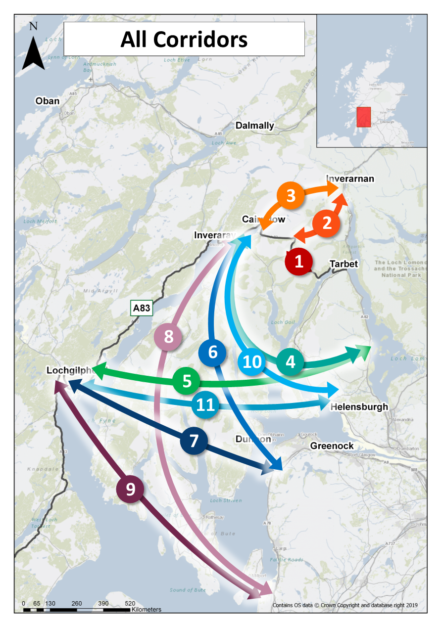
Overview map of the eleven options
This map indicates schematically the eleven options that are under consideration during the first stage of the development work. More detailed maps of each individual option can be found below.
Project Corridor Option Drawings - See descriptions below
- View Corridor 01 - A83 Access To Argyll And Bute
- View Corridor 02 - A83 Access To Argyll And Bute
- View Corridor 03 - A83 Access To Argyll And Bute
- View Corridor 04 - A83 Access To Argyll And Bute
- View Corridor 05 - A83 Access To Argyll And Bute
- View Corridor 06 - A83 Access To Argyll And Bute
- View Corridor 07 - A83 Access To Argyll And Bute
- View Corridor 08a and 08b - A83 Access To Argyll And Bute
- View Corridor 09 - A83 Access To Argyll And Bute
- View Corridor 10 - A83 Access To Argyll And Bute
- View Corridor 11 - A83 Access To Argyll And Bute
Corridor Option 1 - Glen Croe (Existing A83)
This corridor was identified in the A83 Trunk Road Route Study Report, published in 2013.
The Glen Croe (A83 online) sub corridor is adjacent to the existing road corridor starting from the bridge over Coire Croe Burn between the Cobbler and Beinn Luibhean. It is offset from the existing A83 Trunk Road and re-joins the alignment of the existing A83 Trunk Road before the bend prior to the junction with the B828 and the access to the Rest and Be Thankful car park. It is approximately 1.5 kilometres long and would generally follow a similar profile to the existing road.
The Glen Croe (southern side) sub corridor is an off-line corridor within Glen Croe in the area of forestry on the south-west side of the valley. The corridor is approximately 4.3 kilometres in length and ties-in to the existing A83 Trunk Road approximately 3.2 km north-west of Ardgartan, in the vicinity of the A83/Forestry Commission Track & the Old Military Road junction, and the north side of the Rest and Be Thankful car park at the B828. The corridor generally follows the Forestry Track and road structures and ground engineering measures would potentially be required to fit the new road into the topography of this side of Glen Croe.
Corridor Option 2 - Glen Kinglas
This corridor was identified in the A83 Trunk Road Route Study Report, published in 2013.
The Glen Kinglas corridor is off-line within Glen Kinglas and follows the wide valley floor, from the A83 Trunk Road west of the Rest and Be Thankful, heading north-east towards Loch Sloy, and then continuing to the A82 Trunk Road north of Ardlui. The overall length of the corridor is approximately 12 kilometres. The corridor passes through similar terrain to that of the Rest and Be Thankful. Road structures and ground engineering measures would likely be required to fit the new road in the topography of the valley.
Corridor Option 3 - Glen Fyne
This corridor was identified in the A83 Trunk Road Route Study Report, published in 2013.
The Glen Fyne corridor is off-line within Glen Fyne and follows the wide valley floor, from the A83 Trunk Road at the head of Loch Fyne, heading north-east, to the A82 Trunk Road north of Inverarnan. The overall length of the corridor is approximately 15 kilometres. The corridor passes through similar terrain to that of the Rest and Be Thankful. Road structures and ground engineering measures would likely be required to fit the new road in the topography of the valley.
Corridor Option 4 - A82 - Cowal - Cairndow
This corridor was identified in the A83 Trunk Road Route Study Report, published in 2013.
This corridor would be a combination of new offline carriageway and online upgrading works which generally follows the existing road network with a new fixed link crossing at Loch Long.
From east to west, the corridor initially follows the existing A817 and A814 from the A82 Trunk Road north of Arden, to Whistlefield, near Garelochhead, with a new length of road and an approximate 1.4km fixed link crossing at Loch Long to Barnacabber. The corridor then generally follows the existing C09 and A815 to tie back into the A83 Trunk Road at Cairndow. The approximate length of the corridor where no road currently exists is approximately 5.5km with the full corridor approximately 57.9km in length. Construction is required in the vicinity of the Ministry Of Defence (MOD) bases of Faslane and Coulport with a section of the proposed corridor utilising the MOD owned carriageway.
Corridor Option 5 - A82 - Cowal - Lochgilphead
This corridor was initially identified by the Cowal Fixed Link working group and has subsequently been considered as a potential corridor by Transport Scotland’s Strategic Transport Projects Review team.
This corridor would be a combination of new offline carriageway and online upgrading works which generally follows the existing road network with new fixed link crossings at Loch Long and Loch Fyne.
From east to west, the corridor initially follows the existing A817 and A814 from the A82 Trunk Road north of Arden, to Whistlefield, near Garelochhead, with a new length of road and an approximate 1.4km fixed link crossing at Loch Long to Barnacabber. The corridor then generally follows the existing C09 and A815 to Dalinlongart and then the existing B836, A886, C11 and B8000 to Otter Ferry, on the eastern shore of Loch Fyne. An approximate 2.7km fixed link crossing of Loch Fyne ties into the A83 Trunk Road at Port Ann. The approximate length of the corridor where no road currently exists is approximately 5.5km with the full corridor approximately 76km in length. Construction is required in the vicinity of the MOD bases of Faslane and Coulport with a section of the proposed corridor utilising the MOD owned carriageway.
Corridor Option 6 - Inverclyde - Cowal - Cairndow
This corridor was initially identified by the Cowal Fixed Link working group and has subsequently been considered as a potential corridor by Transport Scotland’s Strategic Transport Projects Review team.
This corridor would be generally online linking the A78 Trunk Road at Inverclyde to Cowal, with the provision of a fixed link crossing of the Firth of Clyde.
From south to north, the corridor includes a connection from the A78 Trunk Road to Cowal via an approximate 3.9km fixed link crossing of the Firth of Clyde and upgrades along the A815 corridor, to its connection with the A83 Trunk Road at Cairndow. The approximate overall length of the full corridor is 50.7km in length. The fixed link crossing over the Firth of Clyde will present considerable challenges. This area is used by large marine vessels as well MOD submarines which are based at Faslane and Coulport. The structure will require to span a deep section of the Firth of Clyde as well as have adequate clearance for large marine vessels.
Corridor Option 7 - Inverclyde - Cowal - Lochgilphead
This corridor was initially identified by the Cowal Fixed Link working group and has subsequently been considered as a potential corridor by Transport Scotland’s Strategic Transport Projects Review team.
This corridor would be generally online linking the A78 Trunk Road at Inverclyde to Cowal, with the provision of fixed link crossings of the Firth of Clyde and Loch Fyne.
From south to north, the corridor includes a connection from the A78 Trunk Road to Cowal via an approximate 3.9km fixed link crossing of the Firth of Clyde and upgrades along the A815 corridor between Dunoon and Dalinlongart. The corridor then generally follows the existing B836, A886, C11 and B8000 to Otter Ferry, on the eastern shore of Loch Fyne where an approximate 2.7km fixed link crossing of Loch Fyne ties into the A83 Trunk Road at Port Ann. The approximate overall length of the full corridor is 43.6km in length. The fixed link crossing over the Firth of Clyde will present considerable challenges. This area is used by large marine vessels as well MOD submarines which are based at Faslane and Coulport. The structure will require to span a deep section of the Firth of Clyde as well as have adequate clearance for large marine vessels.
Corridor Option 8a - North Ayrshire - Cairndow via Colintraive
This corridor was identified by Transport Scotland’s Strategic Transport Projects Review team.
This corridor would be a combination of new offline carriageway and online upgrading works which generally follows the existing road network, with new fixed link crossings to the Isle of Bute and Cowal. The corridor includes a connection from the A78 Trunk Road in North Ayrshire to Cowal via a 2.65km and 2.53km fixed link crossing between the mainland (within the vicinity of Portencross) and the Isle of Bute via Little Cumbrae Island and a 0.5km fixed link crossing between the Isle of Bute and Cowal (within the vicinity of the Colintraive to Rhubodach ferry crossing).
From east to west, a new section of carriageway will be required between the A78 Trunk Road and the fixed link crossing to the Isle of Bute. Once on the Isle of Bute, the corridor then generally follows the existing B881, A844 and A886. Once on Cowal the corridor generally follows the A886 again and thereafter the A815 to tie back into the A83 Trunk Road at Cairndow. The approximate length of the corridor where no road currently exists is approximately 6.7km with the full corridor approximately 89.8km in length. The fixed link crossings to the Isle of Bute will provide significant technical challenges. This area is used by large marine vessels as well MOD submarines which are based at Faslane and Coulport.
Corridor Option 8b - North Ayrshire - Cairndow via Dunoon
This corridor was identified by Transport Scotland’s Strategic Transport Projects Review team.
This corridor would be a combination of new offline carriageway and online upgrading works which generally follows the existing road network with new fixed link crossings to the Isle of Bute and Cowal. The corridor involves a connection from the A78 Trunk Road in North Ayrshire to Cowal via a 2.65km and 2.53km fixed link crossing between the mainland (within the vicinity of Portencross) and the Isle of Bute via Little Cumbrae Island and a 2.23km fixed link crossing between the Isle of Bute and Cowal (within the vicinity of the Craigmore and Toward).
From east to west, a new section of carriageway will be required between the A78 Trunk Road and again between the fixed link crossing from the Isle of Bute to the B881. Once in Cowal, the corridor then generally follows the existing B881, A844 and A815 past Dunoon, meeting corridor option 8a again at the junction with the A886 near Strachur, to then tie back into the A83 Trunk Road at Cairndow. The approximate length of the corridor where no road currently exists is approximately 6.7km with the full corridor approximately 76km in length. The fixed link crossings to the Isle of Bute will provide significant technical challenges. This area is used by large marine vessels as well MOD submarines which are based at Faslane and Coulport.
Corridor Option 9 - North Ayrshire - Cowal - Lochgilphead
This corridor was identified by Transport Scotland’s Strategic Transport Projects Review team.
This corridor would be a combination of new offline carriageway and online upgrading works which generally follows the existing road network with new fixed link crossings to the Isle of Bute and Cowal. The corridor includes a connection from the A78 Trunk Road in North Ayrshire to Cowal via a 2.65km and 2.53km fixed link crossings between the mainland (within the vicinity of Portencross) and the Isle of Bute via Little Cumbrae Island and a 0.5km fixed link crossing between the Isle of Bute and Cowal (within the vicinity of the Colintraive to Rhubodach ferry crossing).
From east to west, a new section of carriageway will be required between the A78 Trunk Road and the fixed link crossing to the Isle of Bute. Once on the Isle of Bute the corridor then generally follows the existing B881, A844 and A886. Having crossed to Cowal the corridor generally follows the A886 again up to Ballochandrain. Thereafter to corridor generally follows the C11 and B8000 to Otter Ferry, on the eastern shore of Loch Fyne where an approximate 2.7km fixed link crossing ties into the A83 Trunk Road at Port Ann. The approximate length of the corridor where no road currently exists is approximately 6.7km with the full corridor approximately 62.7km in length. The fixed link crossings to the Isle of Bute will provide significant technical challenges. This area is used by large marine vessels as well MOD submarines which are based at Faslane and Coulport.
Corridor Option 10 - Helensburgh -Cowal - Cairndow
This corridor was identified by the Cowal Fixed Link working group and has subsequently been considered as a potential corridor by Transport Scotland’s Strategic Transport Projects Review team.
This corridor would be generally online linking the A814 at Helensburgh to Cowal, with the provision of fixed link crossings at Gare Loch and Loch Long.
From east to west, the corridor involves a connection from the A814 to Cowal via approximately 0.68km and 2.98km fixed link crossings to the Rosneath Peninsula and the corridor generally follows the B833 whilst on the Rosneath Peninsula. Having crossed Loch Long on the western side of the peninsula, the corridor generally follows the existing A880, C09 and A815 to tie back into the A83 Trunk Road at Cairndow. The approximate overall length of the full corridor is 50.3km in length. The fixed link crossing over Gare Loch and Loch Long will present considerable challenges as both lochs are used by large marine vessels as well MOD submarines which are based at Faslane and Coulport.
Corridor Option 11 - Helensburgh -Cowal - Lochgilphead
This corridor was identified by the Cowal Fixed Link working group and has subsequently been considered as a potential corridor by Transport Scotland’s Strategic Transport Projects Review team.
This corridor is generally online linking the A814 at Helensburgh to Kintyre via Cowal, with the provision of fixed link crossings at Gare Loch, Loch Long and Loch Fyne.
From east to west, the corridor involves a connection from the A814 to Cowal via approximately 0.68km and 2.98km fixed link crossings to the Rosneath Peninsula and the corridor generally follows the B833 whilst on the Rosneath Peninsula. Having crossed Loch Long the corridor generally follows the existing A880 to Ardbeg and the A815 to Dalinlongart, before then following the B836, A886, C11 and B8000 to Otter Ferry on the eastern shore of Loch Fyne. A 2.7km fixed link crossing of Loch Fyne ties into the A83 Trunk Road at Port Ann. The approximate overall length of the full corridor is 48.6km in length. The fixed link crossing over Gare Loch and Loch Long will present considerable challenges as both lochs are used by large marine vessels as well MOD submarines which are based at Faslane and Coulport.