Record of Determination
Project Details
Scheme Background
In September 2016, Amey was commissioned by Transport Scotland to undertake the design and assessment for the A90/A937 Laurencekirk Junction Improvement scheme. The A90 at-grade junctions at Laurencekirk have historical issues relating to safety and delay, and the junctions have been subject to a range of measures aimed at reducing accident frequency and severity. Safety improvements were undertaken in 2005 on the A90 on the approaches to the south junction with the A937, which included the introduction of a 50 miles-per-hour (mph) speed limit and the installation of speed cameras. However, a long running campaign led by the local community, resulted in a petition to the Scottish Government being lodged in February 2009 seeking the construction of a grade separated junction at the A90/A937 southern junction. In January 2016, the Scottish Government announced £24 million for the design and construction of a new grade-separated junction at Laurencekirk as part of a package of additional investment alongside the Aberdeen City Region Deal.
The A90/A937 Laurencekirk Junction Improvement scheme is to comprise of the construction of a grade-separated junction approximately 600m southwest of Laurencekirk in Aberdeenshire. This will replace the existing at-grade crossing where the A937 meets the A90. The scheme will consist of a full diamond layout with dumb-bell roundabouts and four slip roads forming the A90/A937 junction to the south of Laurencekirk. Figure 1.1 within the relevant Environmental Impact Assessment Report (EIAR) drafted in 2019 (hereafter referred to as the 2019 EIAR) for the scheme shows the location of the scheme within Aberdeenshire.
The 2019 EIAR (Volume 2 – Assessment) prepared and published for the proposed scheme, was prepared by Amey and issued to satisfy the requirements of the Environmental Impact Assessment (EIA) Directive (85/337/EEC).
The Roads (Scotland) Act 1984 (Environmental Impact Assessment) Regulations 2017 (Ref. 1.3) implements the Environmental Impact Assessment Directive 2014/52/EU Directive in Scotland in relation to construction projects for new roads and any improvement and maintenance projects for roads. The updated directive provides guidance on the topics to be included within an EIA, such as biodiversity, noise, air quality and landscape. The published 2019 EIAR set out the findings of the full EIA that was undertaken for the scheme.
The project was determined in 2018 as a relevant project in terms of section 20C(16) and section 55A(16) of the Roads (Scotland) Act 1984 as it is a project for the improvement of a road and the completed works (together with any area occupied by apparatus, equipment, machinery, materials, plant, spoil heaps, or other such facilities or stores required during the period of construction);
- exceed 1 hectare in area
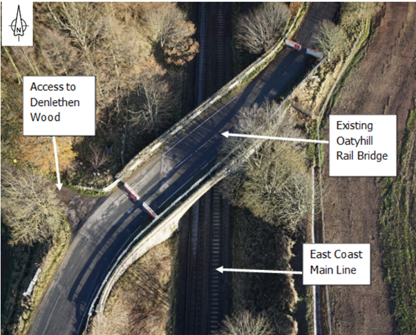
The screening undertaken in 2018 used the Annex III criteria to determine whether a formal Environmental Impact Assessment was required under the Roads (Scotland) Act 1984 as amended by Environmental Impact Assessment (Scotland) Regulations 1999 with a Record of Determination dated 01/11/2018 determining that an Environmental Impact Assessment (EIA) was required for the project. As part of the Laurencekirk junction improvement works, access to an area entitled Oatyhill (currently accessed via a central reserve crossing point) was assessed as part of the 2019 EIAR with the initial intention to close the Oatyhill junction and access the area via the U91K local road over the Oatyhill Rail Bridge connecting to the A937 local realignment. The bridge has since been closed to vehicle traffic for safety reasons (although Non-Motorised Users (NMUs) can still use the structure). The existing Oatyhill major/minor priority junction joins the A90 northbound carriageway approximately 900m southwest of the existing A90/A937 junction. A central reserve opening on the A90 allows for access to the southbound carriageway towards Dundee.
It is therefore proposed to close the Oatyhill junction and the associated central reserve crossing point on safety grounds. With the closure of the existing Oatyhill Rail Bridge and the proposed closure of the Oatyhill junction to the A90, an alternative means of access is required to the four Oatyhill dwellings (and Denlethen Wood) and to allow the A90/A937 Laurencekirk Junction Improvement Scheme to progress. It was concluded that this scheme should therefore involve the provision of a replacement bridge and associated roads spanning the East Coast Main Line at Oatyhill, Laurencekirk.
This Record of Determination considers whether the addition of the replacement bridge and associated roads spanning the East Coast Main Line at Oatyhill, Laurencekirk will result in additional significant impacts or worsening of significant residual impacts than those reported in the EIAR.
Scheme Description
The Access to Oatyhill element of the proposed scheme comprises a new bridge structure crossing over the East Coast Mainline Railway and associated local road realignment to accommodate the new bridge situated along the U91K road linking the area of Oatyhill with Laurencekirk. This element of the scheme is approximately 2.11ha in area (including areas of servitude).
The U91K realignment will tie into the existing road network further along the old trunk road on the eastern side of the existing Oatyhill bridge and tie into the existing road network and local access track towards Denlethen woods on the western side of the existing bridge. The singletrack U91K will contain 1.00m hardstrips, these will change to a carriageway running lane of 3.50m along with a 0.60m hardstanding (northern verge) and a 2.50 hard standing (southern verge) when passing over the new structure. A passing place with a width of 2.55m will be located on the eastern end of the realigned U91K just prior to the new structure, this will increase the overall road width to 8.05m.
For active travel users it is anticipated that all users will share the single track U91K, with a 2.50m wide footpath provided over the structure.
The construction programme is assumed to start in 2026 and anticipated to last for approximately 18 months. This will allow the construction of the structure, local traffic management and phasing for the embankment and all road relating construction. As part of this traffic management, Denlethen Wood Community Woodland will have its vehicular access maintained from the A90 while the works progress by the construction of a temporary access road. The temporary access road will be provided along the western boundary of the acquired land. Pedestrian access will be maintained from the existing access off the B9120 to the west of Laurencekirk. The temporary track will also provide residential, refuge and emergency access to Denlethen Cottage while the works continue until the permanent solution is in place.
Location
The existing Oatyhill major/minor priority junction joins the A90 northbound carriageway approximately 900m southwest of the existing A90/A937 junction at National Grid Reference NO 70222 70102 (refer to Figure 1: Scheme Location).
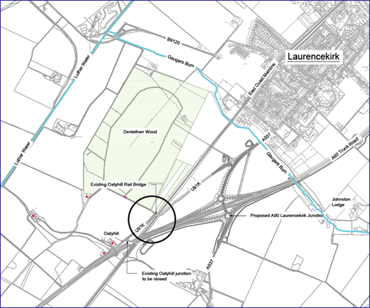
The Oatyhill Rail Bridge is located approximately 500m to the southwest of the existing A937/A90 junction and carries the unclassified U91K over the East Coast Main Line (ECML) Dundee to Aberdeen railway line (refer to Figures 1 and 2).
Description of local environment
Air quality
Baseline air quality levels are likely to be influenced by vehicle traffic from the A90 carriageway and residential/industrial activities from the town of Laurencekirk. The Annual Average Daily Flow (AADF) in 2023 for the A90 carriageway within the scheme extents (estimated count point: 80572), accounted for 17,016 vehicles, with 2,389 of these being Heavy Goods Vehicles (HGVs).
No residential receptors are present within 200m of the scheme extents. A non-residential air quality sensitive receptor in the form of Denlethen Wood Ancient Woodland has been identified within 200m of the scheme extents (to the immediate north).
The Department for Environment, Food and Rural Affairs (DEFRA) UK Ambient Air Quality Map indicates that background NO2 annual mean concentrations are below 10 µg/m³. PM10 background annual mean concentrations are below 13 µg/m³ in the area surrounding the structure whilst PM2.5 background annual mean concentrations are between 3-5 µg/m³. The levels present are all well below the Scottish National Air Quality Objectives of 40 µg/m3 for NO2, 18 µg/m3 for PM10 and 10 µg/m3 for PM2.5.
Aberdeenshire Council has not declared any Air Quality Management Areas (AQMAs). The Aberdeenshire Council’s 2022 Air Quality Annual Progress Report indicates that air quality within their region is good and pollutant concentrations are generally falling.
The Scottish Pollutant Release Inventory (SPRI) has not identified any polluting facilities, locations or points within 1km of the scheme extents other than the town of Laurencekirk.
Cultural heritage
The PastMap resource has not identified any designated culturally significant assets within 300m of the scheme extents. This resource has identified multiple non-designated culturally significant assets within 200m of the scheme (see Table 1, below).
| Name and Designation | Reference Number | Description | Distance from Scheme |
|---|---|---|---|
| Oatyhill, Laurencekirk Environment Record (HER) | NO66NE0342 | Farmstead. | 190m southwest |
| Menmuir - Northwards Canmore | 240498 | Roman Road. | 110m southwest |
| Gavrock Parish HER | NO77SE0032 | Site of former Hunting Lodge. | 40m north |
| Gavrock Farm HER | NO77SW0016 | Polish stone axe of spherulitic rhyolite found c.1964. | 42m north |
| Laurencekirk HER | NO77SW0037 and NO77SW0011 | Site of healing well (believed to be) and location of roman coins (found). | 45m north |
| Kincardineshire Canmores | 80795, 36429, 186853 and 83678 | Axehead found, socketed axehead found (bronze), battleaxe found and general Canmore for Kincardineshire (historic). | 57m north |
| St Medan's Well, Inglismaldie, Gavrock | 36524 | Holy well. | 57m north |
| St Medan's Well HER | NO77SW0036 | Holy well. | 57m north |
Landscape and visual effects
The 1km study area encompasses a few farm steadings and rural properties. The principal land uses consist of arable agricultural land and the ancient woodland of Denlethen Wood. The agricultural land is fairly level and open in character with field boundaries of post and wire fences allowing open views. The largest area of trees is the Community Woodland of Denlethen Wood which is owned and managed by Forestry and Land Scotland. This has been designated as Ancient Woodland, comprising principally coniferous species with mixed, deciduous species on the periphery. There are young to mature trees alongside the Oatyhill Road leading to Oatyhill Rail Bridge.
There are fourteen visual receptors within the 1km study area. Seven of which are residential receptors, four are recreational receptors (including Denlethen Wood and its associated core paths). Other receptors include motorists, farm workers and Friends of Denlethen Wood who maintain Denlethen Wood.
The Scheme is located in the Landscape Character Type (LCT 22) Broad Valley Lowlands – Aberdeenshire and between two local landscape designations:
- Garvock and Glenbervie – located mainly to the east of Denlethen Wood and Laurencekirk; and
- Howe of the Mearns – mainly to the west of the Oatyhill Road leading to Oatyhill Bridge.
There are no designated landscapes of national, regional or local landscape importance within the study area, and there are no Gardens and Designed Landscapes (GDL), Special Landscape Areas (SLA), Conservations Areas (PastMap) or Tree Preservation Orders. Scotland’s Ancient Woodland Inventory (AWI), however, identifies four areas of priority woodland habitat within proximity to Oatyhill Junction. The priority woodland habitat areas are:
- Denlethen Wood – Woodland is primarily coniferous woodland plantation with scattered broadleaved woodland plantation along the boundary of Denlethen Wood. Located in close proximity approximately 10m north of the works;
- Unnamed woodland by Oatyhill Cottage – Located approximately 420m south-west of the works;
- Unnamed strips in fields – Located approximately 370m south of the works; and,
- Unnamed minor woodland by Newton Cottage – Located approximately 420m of the works.
The landscape fabric can be described as being large-scale with generally open views due to the large fields, post and wire fences and low topography with a backdrop of distant hills. Denlethen Wood is located immediately north of the Scheme restricting views across the landscape. The topography begins to rise to the east of the A90. The A90 acts as a barrier to movement, particularly non-motorised users (NMU), to the southeast of Oatyhill Rail Bridge. The A90 also influences the landscape character and visual amenity by introducing a linear feature, noise and movement into the area. Throughout the landscape of the study area there are occasional stone-built farmsteads, cottages and houses that give the area a settled rural character.
Scotland’s Soil Map classifies the land as ‘2’ with regard to the Land Classification for Agriculture. Scotland’s Historic Land-Use Map lists the land surrounding the scheme extents as a mixture of rough grazing, plantation, managed woodland, rectilinear fields and farms and major motorways and roads.
Biodiversity
Habitats of ecological interest noted within the area include arable land, which could support breeding birds and provide potential feeding grounds for overwintering bird populations. In addition, watercourses such as field drains and the Luther Burn could provide commuting routes for aquatic species.
No designated European sites have been identified within 2km of the scheme extents. No nationally designated sites (such as Sites of Special Scientific Interest (SSSIs) or local/national nature reserves) have been identified within 200m of the scheme extents however, West Bradieston and Craig of Garvock SSSI (NatureScot Site ID: 1603) is present at the edge of the study area and outside the Zone of Influence of the scheme (NatureScot’s Sitelink).
Scotland’s AWI, has identified four areas of priority woodland habitat within proximity to Oatyhill Junction. The priority woodland habitat areas are:
- Denlethen Wood – Woodland is primarily coniferous woodland plantation with scattered broadleaved woodland plantation along the boundary of Denlethen Wood. Located in close proximity approximately 10m north of the works;
- Unnamed woodland by Oatyhill Cottage – Located approximately 420m south-west of the works;
- Unnamed strips in fields – Located approximately 370m south of the works; and,
- Unnamed minor woodland by Newton Cottage – Located approximately 420m of the works.
Follow-up protected species surveys were carried out in 2022.
No invasive species were identified within the footprint of the Scheme, or in proximity to Oatyhill Junction itself.
Geology and soils
The scheme is not located within 200m of any Geological Conservation Review sites (GCRs), or SSSIs designated for their geological significance (NatureScot’s Sitelink).
The James Hutton Institute Soil map of Scotland indicates the majority of soils within the study area to be either brown forest soils with gleying, some brown forest soils and noncalcareous gleys or humous-iron podzols freely drained soils, both derived from Lower Old Red Sandstone marls, mudstone or sediment
Bedrock Geology is described within a 250m study area as the Cromlix Mudstone Formation. Superficial deposits within the study area comprise of till (Devensian – Diamicton).
The site has a limited industrial history with potential sources of contamination being the road and railway and made ground associated with both.
The study area contains a number of Water Framework Directive (WFD) and non-WFD watercourses. Luther Water, Ducat Water and Devilly Burn have all been classified under the WFD, while Gaugers Burn and a number of minor, unnamed watercourses have not been classified. None of the watercourses within the study area are designated under European or UK law, and the watercourses are further not hydrologically connected to any designated sites. Gauging data is only available for Luther Water where the monitoring point lies out with the study area and shows the Q95 as <1.0m3/s.
The study area is underlain by the bedrock aquifer Old Red Sandstone (South). This is the principal aquifer for the region and is classified as a sedimentary aquifer which is dominantly non-calcareous. The aquifer is defined by the British Geological Survey as of moderate to very high productivity.
The Laurencekirk groundwater body (Scottish Environment Protection Agency (SEPA) ID: 150963) is present below the study area. This is classified under the WFD as having an overall status of ‘Poor’ (SEPA).
Previous interviews with local landowners for the A90 Improvements at Laurencekirk scheme have further indicated that groundwater is of some use to the local community, particularly agriculture, through the use of private water supplies supplied by springs and wells.
Material assets and waste
Material resources may originate offsite, with some from on-site such as excavated natural materials, or recycled road plainings. Surplus materials generated from the construction process which are unsuitable for re-use on-site are designated as waste. The existing railway bridge that was assessed within the 2019 EIAR preferred option is not being demolished as part of this project.
Quantities include high-level cut and fill estimates for the Scheme, along with estimates of materials required for the structure, road pavement and areas of site clearance required.
Table 2 presents the key material use and waste generated estimates for the construction of the Scheme.
| Material | Quantity |
|---|---|
| Length of structure (m) | 36 |
| Volume of Cut (m3) | 2154 |
| Volume of Fill required (m3) | 8559 |
| Volume of Suitable excavated material (m3) | 6238 |
| Imported material (m3) | 6405 |
| Aggregate (m3) | 839 |
| Asphalt (m3) | 661 |
| Concrete (m3) | 486 |
| Metal/steel (t) | 94 |
| Wood (m3) | 635 |
| Disposal of acceptable material (m3) | 3311 |
| Potential to generate hazardous waste | Slight |
The following five operational landfill sites have been identified within the Aberdeenshire Council area (using 2022 data) (SEPA):
- Easter Hatton Environmental LTD, Balmedie – Non-hazardous landfill with 1.73 million tonnes remaining capacity and an annual capacity of 190,000 tonnes. The estimated date for ceasing landfill for this site is 2057.
- Stoneyhill Environment Park, Peterhead, Aberdeen – Non-hazardous landfill with 773,000 tonnes remaining capacity and an annual capacity of 355,000 tonnes. The estimated date for ceasing landfill for this site is 2025.
- Joss (Aberdeen) LTD, Parkhill, Dyce, Aberdeen – Inert landfill with a remaining capacity of 120,000 tonnes and an annual capacity of 100,000 tonnes. The estimated date for ceasing landfill for this site is 2035.
- Chap (Aberdeen) Quarries LTD, Park Quarry, Kincluny Farm, Durris - Inert landfill with a remaining capacity of 653,000 tonnes and an annual capacity of 75,000 tonnes. The estimated date for ceasing landfill for this site is 2032.
- Savoch Quarry Landfill Site, Peterhead, Aberdeen – Non-hazardous landfill with 59,000 tonnes remaining capacity and an annual capacity of 24,999 tonnes. The estimated ceasing date for landfill at this site is 2069. The low capacity of this landfill means it is unlikely to be able to serve the Scheme.
There is only one waste facility registered for special wastes in Scotland: Avondale Hazardous Landfill Site, Falkirk. This was only anticipated to remain in operation until 2023 however, it would appear to still be in operation.
The main sources of contamination are considered to be made ground on site, associated with the railway line, the U91K road and the A90 trunk road.
Noise and vibration
Baseline noise levels are likely to be influenced by vehicle traffic from the A90 carriageway and residential/agricultural activities. The AADF in 2023 for the A90 carriageway within the scheme extents (estimated count point: 80572), accounted for 17,016 vehicles, with 2,389 of these being HGVs.
Three residential noise-sensitive receptors have been identified within 600m of the scheme extents with the closest of these (Oatyhill) located approximately 380m east). No non-residential noise sensitive receptors have been identified within 600m of the scheme extents. No vibration sensitive receptors have been identified within 100m of the scheme.
Scotland’s Noise Map indicates the consolidated day-evening-night (Lden) noise levels within the scheme extents to be between 51dB and 73dB. The A90 carriageway adjacent to the scheme extents is not located within a Candidate Noise Management Area (CNMA) as defined by the Transportation Noise Action Plan (Road Maps) Transportation Noise Action Plan (TNAP).
Population and human health
The study area (500m) is predominantly rural with scattered private properties. The projected percentage change in households in Aberdeenshire between 2016 and 2041 is between 10% to 25% increase and there is one area of land allocated for housing within the study area, known as OP2. The site was granted Full Planning Permission in October 2012 for 210 properties. There are four private properties to the west of the scheme that require access via the Oatyhill Rail Bridge.
Denlethen Wood is located approximately 270m north west of the existing Oatyhill Rail Bridge. The Oatyhill Rail Bridge would provide vehicle access to the woodland.
The nearby town of Laurencekirk provides community land and assets including Laurencekirk Primary School, Mearns Academy Community Campus, Dickson’s Community Hall, Mearns Community Centre, the Post office and library, Laurencekirk Cemetery, Kinner Square, Memorial Park and several Community Housing areas.
There are no areas of land allocated for strategic employment, development land areas or existing businesses/employment sites within the study area.
Agricultural practices appear to be predominantly arable within the study area with some fields for animal grazing.
The local carriageway and the A90 carriageway within the study area is not street-lit and contains little-to-no pedestrian footways (although the current Oatyhill structure is still open to non-vehicle traffic). A layby (northbound) is present within the study area on the A90 carriageway whilst passing places are present on the U91K local road present. No bus stops are present within the study area. Field access points are also present within the study area.
Aberdeenshire Council Core Path 511.01 has been identified within the study area within Denlethen Wood.
No National Cycle Network (NCN) routes have been identified within the study area.
Road drainage and the water environment
The study area lies within the River North Esk (Tayside) Catchment. According to SEPA’s Water Classification Hub there are four surface watercourses within this catchment, that flow directly through the study area. These are:
- Gaugers Burn - there is no information relating to the overall water quality of this Burn.
- Kirk Burn - there is no information relating to the overall water quality of this Burn.
- Luther Water - (Source to Dowrie Burn confluence) (SEPA ID: 5706) is classified as being in ‘Moderate’ condition under the WFD. The watercourse has been designated as ‘Heavily Modified’ on account of physical alterations that cannot be addressed without a significant impact on the drainage of agricultural land.
- Ducat Water - (SEPA ID: 5709) classified as being in ‘Good’ condition. The watercourse has been designated as being ‘Heavily Modified’ due to physical alterations for agricultural land drainage.
- Devilly Burn - (SEPA ID: 5708) classified as being in ‘Good’ condition under the WFD. The watercourse is not designated as ‘Heavily modified’.
According to the Drinking Quality Regulator for Scotland (DWQRS) there are no Type A or Type B Private Water Supplies fed by surface water within the study area. Previous interviews with landowners for the A90 Improvements at Laurencekirk Project, have however revealed that groundwater is of some use to landowners in the wider Laurencekirk area.
According to SEPA's Water Classification Hub, there are two groundwater bodies that are present below the study area: Laurencekirk (SEPA ID: 150963) and North Esk Sand and Gravel (SEPA ID: 150803).
The Laurencekirk groundwater body covers an approximate area of 308.6 sq. km and covers the majority of the study area. It is classified under the WFD as having an overall status of ‘Poor’. The water quality of the groundwater is impacted by diffuse pollution from rural sources.
The North Esk Sand and Gravel groundwater body lies below a small section of the study area. Similar to the Laurencekirk groundwater body, it is classified under the WFD as having an overall status of ‘Poor’. The water quality is impacted by diffuse pollution from rural sources.
SEPA’s Flood Map has indicated localised areas of the verge of the A90 carriageway adjacent to the scheme extents, and areas of the railway line traversing the area of works to be at a ‘Medium’ (approx. 0.5%) to ‘High’ (approx. 10%) risk of surface water flooding each year. No areas of the area of works are at risk of river water flooding according to this resource however, the Luther Water to the north of the scheme is at a ‘High’ risk of river water flooding each year.
The A90 carriageway adjacent to the scheme extents, and the local road within are drained via top-entry gullies.
The scheme extents are contained within the Scottish Government’s Strathmore and Fife (including Finavon) Nitrate Vulnerable Zone (NVZ). NVZs are areas designated as being at risk from agricultural nitrate pollution. Areas such as the Strathmore and Fife (including Finavon) NVZ either result or would likely result in a concentration equal or exceeding 50mg/l of nitrates in either surface or groundwater as a result of agriculture.
Climate
Table 2 within the Material Assets and Waste sets out the estimated material quantities required to construct the scheme. The current operational maintenance Greenhouse Gas (GHG) emissions, and operational user GHG emissions are unavailable at the time of writing.
The Met Office generates climatologies for different areas of the UK, known as climate districts, including historical regional climate information. The schemes is located within Eastern Scotland’s regional climate. High-level climate observations for Eastern Scotland over a 30-year averaging period between 1981-2010 are presented in Table 3 below.
|
Parameter |
Eastern Scotland’s Climate Observations |
|---|---|
|
Temperature |
Annual mean temperatures vary from 9 °C close to the Firth of Forth to less than 6 °Cover the higher ground of the Grampians, A90/A937 Laurencekirk being situated closer to the latter. The mean temperature drops to its coldest around January where it can range from 2 °C in areas of East Lothian and Fife bordering the Firth of Forth and on the NE coast of Grampian, to less than -2 °C covering the higher ground. Temperatures are generally at their highest in July where daily maximum temperatures at low levels inland approaching 20 °C, and less than 17 °Cover the higher ground and along the coast of the Grampian region. |
|
Sunshine |
The number of hours of bright sunshine is controlled by the length of day and by cloudiness. In general, December is the dullest month and May or June is the sunniest. Sunshine duration decreases with increasing altitude, increasing latitude, distance from the coast, sheltered topography and pollution. Eastern Scotland includes the sunniest places in Scotland, these being on the coast of Fife where the average is about 1,500 hours per year |
|
Rainfall |
Rainfall is generally well-distributed throughout the year. The frequency of Atlantic depressions is normally greatest during the autumn and winter but, unlike other parts of the UK, Scotland tends to remain under their influence for much of the summer too. The wettest months tend to be in autumn and early winter. High altitudes are associated with greater rainfall. Much of Eastern Scotland is sheltered from the rain-bearing westerly winds. This shelter reaches its greatest potential along the coasts of East Lothian, Fife and the Moray Firth and these areas receive less than 700 mm of rainfall in an average year. In contrast, the wettest area is the southern Grampians where the average annual rainfall is over 1500 mm. These values can be compared with annual totals of around 500 mm in the driest parts of eastern England and over 4000 mm in the western Scottish Highlands. In winter (December to February), there are about 30 wet days on average along the coasts of East Lothian and Fife, rising to over 55 days in the Grampian mountains. In summer (June to August) the East Lothian and Fife coasts have about 27 wet days and the Grampian Mountains over 40 days. Periods of prolonged rainfall can lead to widespread flooding, especially in winter and early spring when soils are usually near saturation and snowmelt can be a contributing factor. |
|
Wind |
Eastern Scotland is one of the windier parts of the UK, being relatively close to the track of Atlantic depressions. The strongest winds are associated with the passage of deep areas of low pressure close to or across the UK. The frequency and strength of these depressions are greatest in the winter half of the year, especially from December to February, and this is when mean speeds and gusts (short duration peak values) are high. The penetration of westerly winds into eastern Scotland is controlled to a large extent by topography, with the Central Lowlands assisting this but the higher ground on either side providing shelter. Springtime tends to have a maximum frequency of winds from the north east. |
|
Snowfall |
Over most of the area, snowfall is normally confined to the months from November to April, but upland areas often have brief falls in October and May. Snow rarely lies at lower levels outside of the period November to April. On average, the number of days with snow falling is about 20 per winter along the coast but over 80 days over the Grampians. The number of days with snow lying has a similar distribution, with less than 10 along the East Lothian coast but over 60 days over the higher ground of Grampian. These averages can be compared with the coasts of SW England where less than 3 days per year have lying snow. |
A Local Climate Impacts Profile (LCLIP) for Aberdeenshire Council was developed by the UK Climate Impacts Programme (UKCIP) to assist local authorities and organisations to assess their exposure and vulnerability to past weather events, as a step towards preparing for future risks.
Table 4 (below) summarises the primary weather events affecting the region between 2019 and 2022 and provides a high-level overview of the impacts experienced.
| Weather Event | Impact |
|---|---|
| Heavy rain/Flash floods | 13 incidents of excessive rainfall causing surface water flooding, town flooding, and building damage. This has led to significant infrastructure damage and service disruption, affecting community life and safety. |
| Storms and high winds | There were 18 storm incidents resulting in building damage, debris on roads, and power failure. These events have caused substantial economic losses for businesses and required financial assistance from government schemes. |
| Extreme low temperatures/ snow and ice | 11 periods of snow/ice had impacts like round-the-clock gritting and transport network disruption. This has disrupted council services, including waste management, transportation, and school operations. |
| Extreme high temperatures/heatwaves | 9 occurrences of heatwaves led to water shortage and increased air pollution. These events have highlighted the need for effective climate change adaptation strategies to manage future climate risks effectively. |
Future projected climate conditions and extreme weather events for the area encompassing the schemes for the 2020s and 2080s are detailed below. These time periods cover the assumed construction period (commencing in early 2026 for a period of 24 months) and the assumed 60-year operational life (2028 to 2087).
Using the historical baseline data, two methods were implemented to establish the future climate baseline:
- The changes in average climate conditions were obtained from the UKCP18 probabilistic projections of climate change
- The changes in extreme weather events were obtained using UKCP18 regional projections.
Climate change projections for a range of meteorological parameters are presented for different probability levels within the RCP8.5 high emission scenario for the near-term and long-term future time periods. Table 5 presents changes in extreme weather events for the 2020s and 2060s, such as number of heavy rain days and Table 6 presents expected changes in climate conditions, such as mean temperature and precipitation for the 2020s and 2080s.
| Parameter | Baseline (1981 - 2010 | 2000s Min | 2000s Mean | 2000s Max | 2060s Min | 2060s Mean | 2060s Max |
|---|---|---|---|---|---|---|---|
| Temperature: Number of frost days (daily minimum temperature equal or lower than 0°C) | 48.2 | 46.1 | 44.0 | 40.2 | 39.2 | 36.0 | 32.1 |
| Temperature: Heatwaves (2 days with a maximum temperature higher than 29°C and a minimum temperature higher than 15°C) | 0.2 | 0.1 | 0.8 | 1.6 | 2.6 | 3.5 | 4.4 |
| Temperature: Annual Count of Tropical Nights (minimum temperature above 20°C) | 0.1 | 0.1 | 0.2 | 0.5 | 0.8 | 1.5 | 2.6 |
| Precipitation: Dry spells (10 days or more with no precipitation) | 6.2 | 5.4 | 6.4 | 7.0 | 6.4 | 7.2 | 8.0 |
| Precipitation: Annual number of days per year when precipitation is greater than 25mm per day (Met Office definition of 'heavy rain). | 1.4 | 1.0 | 1.6 | 2.2 | 4.1 | 5.2 | 6.6 |
| Wind above 10m/s | 1.1 | 0.2 | 1.0 | 2.4 | 0.2 | 1.1 | 2.7 |
| Parameters | Baseline | 2020s: 10th percentile | 2020s:50th percentile | 2020s:90th percentile | 2060s: 10th percentile | 2060s: 50th percentile | 2060s: 90th percentile |
|---|---|---|---|---|---|---|---|
| Temperature (°C): Mean winter daily temperature | 4.5 | -0.2 | 0.7 | 1.7 | 0.5 | 2.2 | 3.6 |
| Temperature (°C): Mean summer daily temperature | 16.1 | 0 | 0.7 | 1.7 | 0.8 | 2.7 | 4.2 |
| Precipitation (% change from baseline): Winter mean precipitation rate | 2.3mm | -5 | 12 | 25 | -10 | 18 | 42 |
| Precipitation (% change from baseline): Summer mean precipitation rate | 2mm | -15 | -5 | 12 | -40 | -15 | 10 |
Policies and Plans
This Record of Determination (RoD) has been undertaken in accordance with Roads (Scotland) Act 1984 (Environmental Impact Assessment) Regulations 2017 (RSA EIA Regulations) along with Transport Scotland’s Environmental Impact Assessment Guidance (Guidance – Environmental Impact Assessments for road projects (transport.gov.scot)). Relevant guidance, policies and plans accompanied with the Design Manual for Roads and Bridges (Design Manual for Roads and Bridges (DMRB)) LA 101 and LA 104 were used to inform this assessment.
Other national, regional and local planning and policy documents used to inform this Record of Determination include:
- Scotland’s National Planning Framework (NPF4) of which sets Scotland’s spatial principles, regional priorities, national developments and national planning policy and thus brings together plans and strategies for transport development in Scotland;
- The Aberdeen City and Shire Strategic Development Plan 2020 of which details the strategy for the growth of the Aberdeen City and Aberdeenshire areas of northeast Scotland; and
- The Aberdeenshire local Development Plan (LDP) 2023 of which promotes a successful, sustainable, low carbon, natural, resilient and connected Aberdeenshire.
Description of main environmental impacts and proposed mitigation
Air quality
Impacts
- On site construction activities carry a potential to produce airborne particulate matter and dust and generate emissions that may have a temporary impact on local air quality levels and act as a nuisance to nearby residents. Light and Heavy-Duty vehicle trips will be generated over the schemes construction phase, resulting in additional emissions of NOX, NO2, PM10 and PM5 on the local road network surrounding the scheme.
- As a result of increased proximity, there is the potential for the access to Oatyhill element of the scheme to result in minor effects (from dust emissions etc.) on Denlethen Wood Ancient Woodland and properties within 250m.
Mitigation
- Best practice and measures as outlined in the ‘Guidance on the assessment of dust from demolition and construction (January 2024)’ published by the Institute of Air Quality Management (IAQM), which includes (but is not limited to the following mitigation relevant to this scheme will be followed:
- The site layout will be planned (including plant, vehicles and Non-Road Mobile Machinery (NRMM)) so that machinery and dust causing activities are located away from receptors, as far as reasonably practicable;
- Materials that have a potential to produce dust will be removed from site as soon as possible, unless being re-used on site (cover or fence stockpiles will be used to prevent wind whipping);
- Cutting, grinding or sawing equipment will be fitted or used in conjunction with suitable dust suppression techniques such as water sprays or local extraction, e.g. suitable local exhaust ventilation systems;
- Drop heights from conveyors and other loading or handling equipment will be minimised;
- Vehicles carrying wastes and materials entering and leaving the work area will be covered to prevent escape of materials during transport;
- Equipment will be readily available on site to clean any dry spillages, and clean up spillages as soon as reasonably practicable after the event using wet cleaning methods; and
- When not in use, plant, vehicles and NRMMs will be switched off and there will be no idling vehicles.
- Plant, vehicles and NRMM will be regularly maintained, paying attention to the integrity of exhaust systems to ensure such fuel operated equipment is not generating excessive fumes.
- Green driving techniques will be adopted, and effective route preparation and planning will be undertaken prior to works.
- Where possible, materials will be sourced locally.
- Surfaces will be swept where loose material remains following planing.
Conclusion
The 2019 EIAR assessed air quality impacts at sensitive receptors for the entirety of the A90/A937 Laurencekirk Junction Improvement scheme and all were found to be negligible, at worst case receptor locations. The regional air quality effects were found to be not significant. With best practice mitigation measures in place, as set out in the EIAR, it is considered that addition of the Access to Oatyhill will not result in any new or different baseline conditions or significant effects to those reported in the EIAR and will not alter the findings or conclusion of the EIAR assessment.
Cultural heritage
Impacts
- There is the potential for non-designated culturally significant assets to be impacted by the scheme.
- There is potential for works to encounter unknown heritage assets where the options impact land not previously impacted by existing rail and road infrastructure. Where the scheme impacts subsurface remains, the nature, value and impacts on any assets will be unknown.
Mitigation
- It is recommended that the site induction for the construction phase will make all site operatives aware of the potential for buried archaeological material to be uncovered during the works.
- Any offline route elements through greenfield areas will be subject to preliminary archaeological investigation. Measures will be outlined within a Written Scheme of Investigation (WSI) in line with the Chartered Institute for Archaeology (CIfA) relevant Standards and Guidelines which should consider the use of trial trenching, geophysical survey and other appropriate methods, in line with Transport Scotland’s Guidance Note on Archaeology and Trunk Roads, and will be undertaken ahead of the construction stage to permit suitable identification, investigation, recording and retrieval of all appropriate materials.
Conclusion
The 2019 EIAR identified five undesignated HERs in close proximity to each other within the field west of the works at Oatyhill bridge. Due to the introduction of the Access to Oatyhill element of the scheme, these cultural heritage assets are now closer to the construction works however, there will be no change to the assessment of significance within the 2019 EIAR as these are all previous finds and the mitigation proposed within the 2019 EIAR remains valid. With best practice mitigation measures in place, it is considered that addition of the Access to Oatyhill will not result in any new or different baseline conditions or significant effects to those reported in the EIAR and will not alter the findings or conclusion of the EIAR assessment.
Landscape and visual effects
Impacts
- The alteration and loss of landscape fabric has the potential to alter the landscape character by changing land cover, the pattern of vegetation in the landscape and therefore the way in which the landscape is perceived.
- The alteration and loss of landscape fabric also has the potential to result in impacts upon visual receptors by opening up views across the landscape or changing the composition and quality of views. Construction activities, task lighting, storage of materials and traffic management will temporarily be visible resulting in constantly changing views during construction.
- The effects of removal of vegetation will be long term. New structures such as the bridge and signage may require the removal of the existing vegetation.
- Impacts within the construction corridor may persist into the operational stage prior to mitigation becoming established or as a result of permanent loss of vegetation.
- The Denlethen Wood Ancient Woodland is likely to be impacted by the scheme. Trees situated within the Ancient Woodland Denlethen Wood are not expected to be affected, however removal of existing vegetation and trees within the buffer zone of the ancient woodland will likely have an effect on the landscape with partial loss or noticeable damage to the existing character.
- The baseline landscape and visual conditions from the 2019 EIAR remain unchanged, with the same 2km landscape study area previously used still relevant in this instance regarding the Access to Oatyhill element. Therefore; the overall residual effects on landscape and visual amenity remain unchanged with the introduction of the Access to Oatyhill scheme.
Mitigation
- It is recommended that a Landscape Maintenance and Monitoring Plan (LMMP) is developed. This plan would set out the mitigation measure and commitments agreed to and delivered, together with any specific management needed and/or monitoring requirements over an agreed timeframe.
- During construction the working corridor will be minimised to reduce the need to remove existing vegetation and minimise disturbance to existing ground and soil. As the development requires the clearance of vegetation within the working area only trees or vegetation adjacent to the working area can be retained.
- Construction compounds will be sited and designed to minimise effects on vegetation and soil. Construction traffic and plant and the presence of task lighting and signage will be managed to minimise effects which will be of short duration.
- Mitigation will include the following:
- Siting and design of construction compounds to minimise visual impact;
- Use of hording to minimise visual impact of construction compounds and activities;
- Use of cowls and directional units for task lighting; and
- Siting and heights of storage materials to minimise visual impacts.
- Mitigation planting will seek to avoid emphasising the scheme as a new feature visible in the landscape and will take into account the need to preserve key views across the open landscape or to important features such as woodland.
Conclusion
The baseline landscape and visual conditions from the 2019 EIAR remain unchanged, with the same 2km landscape study area previously used still relevant in this instance regarding the Access to Oatyhill element. With best practice mitigation measures in place, it is considered that addition of the Access to Oatyhill will not result in any new or different baseline conditions or significant effects to those reported in the EIAR and will not alter the findings or conclusion of the EIAR assessment.
Biodiversity
Impacts
- During night-time programming, misdirected site lighting and additional noise could cause temporary disturbance to any surrounding nocturnal species.
- There is potential for protected species to be active within the surrounding area and for the works to result in disturbance to these species.
- There is potential for the Denlethen Wood ancient woodland to be impacted by the scheme.
- There is potential for aquatic pollution (through diffusion into the surrounding environment) as a result of the scheme.
Mitigation
- Any vegetation clearance will ideally be undertaken out with March to August inclusive, in order to avoid the bird nesting season. Otherwise, an Ecologist/Ornithologist will carry out a nest check within 48 hours prior to the vegetation being cleared.
- A pre-construction survey will be undertaken to ensure no change from the baseline identified during previous surveys.
- All site lighting will be directed away from sensitive ecological receptors such as woodland and watercourses.
- Felling (where necessary) will take place between October and January (inclusive) within woodland.
- Mitigating impacts on aquatic species predominantly includes maintaining the quality of the water environment. Therefore, pollution prevention and sediment control measures will be in place to ensure impacts are minimised.
- In the event that protected species are sighted, works will temporarily be suspended until the animal has moved on.
- All works and storage of plant, machinery, vehicles and equipment will be restricted to hardstanding areas where applicable.
- Noise mitigation measures as outlined in the Noise and Vibration section and pollution control mitigations as outlined in the Road Drainage and the Water Environment section will be adhered to during the works.
Conclusion
Due to time lapsed since the 2019 EIAR, protected species surveys were repeated to ensure the original assessment of the area surrounding the scheme remains accurate. The results of these surveys confirm that there are no substantive changes to the ecological baseline of the A90/A937 Laurencekirk Junction Improvement Scheme and consequently, the potential impacts of the scheme on biodiversity will be largely unchanged following the introduction of the Access to Oatyhill element. With best practice mitigation measures in place, it is considered that addition of the Access to Oatyhill will not result in any new or different baseline conditions or significant effects to those reported in the EIAR and will not alter the findings or conclusion of the EIAR assessment.
Geology and soils
Impacts
- There is potential for pollutants to enter groundwater or enter runoff to surface waters, adversely affecting water quality during excavations of potentially contaminated soils or from spills, leaks or seepage of fuels from machinery.
- Excavation will result in soil disturbance, which can create adverse conditions, including erosion and polluted soils.
- The generation of concrete dust can raise the pH of soil resulting in erosion and soil infertility.
- Plant, vehicles and machinery on the soft-verge have the potential to impact soils.
- Should piling be utilised as a construction method, there is the potential for direct impact on soils, geology and the water table.
- Once operational, impacts on geology, soils and groundwater may occur due to spillages or contamination from routine maintenance operations.
- The introduction of temporary access tracks, and the taking of farmland for the scheme will impact the soils present.
Mitigation
- One of the main ways to reduce the impact on geology is to reuse excavated material on site to reduce the requirement for importing virgin materials.
- All excavated material reuse will be undertaken in accordance with guidelines provided within the Government’s ‘Construction Code of Practice for the Sustainable Use of Soils on Construction Sites’, and SEPA guidance ‘Promoting the sustainable reuse of greenfield soils in construction’.
- Adherence to good practice measures and pollution prevention measures will ensure any impacts on soils from pollution will be minimised.
- Techniques used will include catching any surface water run off before it enters ground/surface water drains to full soils and groundwater geochemical classification and utilising safe systems of work.
- Contingency measures will be put in place to manage any localised hotspots of land contamination and other as yet unidentified areas of land contamination during earthworks including safe working practices and materials reuse/ disposal assessments.
- Excavated soils must be appropriately contained/covered and protected from the elements. Excavation of soils should be kept to a minimum and only where necessary, with any excavated soils being re-used on site as far as reasonably practicable.
- Dust suppression systems, such as dampening down or use of collection vacuums, must be used when cutting concrete.
Conclusion
The Access to Oatyhill element to the A90/A937 Laurencekirk Junction Improvement scheme will not alter the baseline conditions, impact assessment, mitigation measures, and residual effects from the 2019 EIAR due to the area of works being contained within the original study area. With best practice mitigation measures in place, it is considered that addition of the Access to Oatyhill will not result in any new or different baseline conditions or significant effects to those reported in the EIAR and will not alter the findings or conclusion of the EIAR assessment.
Material assets and waste
Impacts
Table 7 sets out the main impacts of the Scheme with regard to materials and wastes.
| Assessment Category | Result |
|---|---|
| % overall material recovery/recycling (by weight) of non-hazardous Construction and Demolition Waste (CDW) | 79 |
| Reused/recycled content of imported aggregates | in line with relevant regional percentage target |
| % reduction or alteration in the regional capacity of landfill | <1 |
| % of project waste for disposal outside of the region | 0 |
| Significance category | Slight |
- The works will result in contribution to resource depletion through use of virgin materials.
- GHG emissions will be generated by material production and transportation to and from site.
- Energy will be required for the scheme in the form of non-renewable fossil fuels for transport of materials and personnel, and for plant operation. The use of non-renewable fuels to power plant and machinery will be a contributing factor to Greenhouse Gas (GHG) emissions.
Mitigation
- As with every construction project, best practice will be followed at all times to reduce wastage and reduce the quantity of raw materials needed to construct and maintain the project.
- Throughout the construction of the scheme, it is recommended that recycling and reuse policies be followed wherever possible, in order to reduce wastage and minimise surplus materials. Waste streams will be segregated and stored appropriately. Disposal of waste will follow duty of care protocols and waste will be removed off site by licensed waste carriers.
- A Site Waste Management Plan (SWMP) will be developed by the contractor, to maximise use of existing resources and reduce waste. This approach will also reduce costs associated with transport and sourcing fill materials.
- Any vegetation removal will be mulched, subject to regulatory permissions and approval, and used within new landscape areas. Topsoil stripped during site clearance and initial ground preparation would be stored and reused on verges and embankments.
- To maximise the reuse of existing materials on site, consideration will be given to recycling road planings and use as aggregates in the sub-base layers. This would be subject to agreement and appropriate registration with the SEPA prior to work commencing. Recycled aggregates can be sourced for road construction to reduce costs and improve sustainability of the scheme. SEPA has provided guidance in documents ‘Guidance on the production of fully recovered asphalt road planings’ and ‘Recycled Aggregates from Inert Waste’.
- The Use of locally sourced materials and ordering materials only as and when required, can reduce the amount of excess materials wastage and reduce transport costs and carbon footprint.
Conclusion
The Access to Oatyhill element of the A90/A937 Laurencekirk Junction Improvement Scheme, and the volumes associated with materials required and wastes generated will not impact the outcome of the 2019 EIAR. With best practice mitigation measures in place, it is considered that addition of the Access to Oatyhill will not result in any new or different baseline conditions or significant effects to those reported in the EIAR and will not alter the findings or conclusion of the EIAR assessment.
Noise and vibration
Impacts
- Prolonged noise and vibration heavy works will likely be required, which could cause disturbance for nearby sensitive receptors such as protected species, residential properties at Oatyhill and nearby amenity users such as those utilising Denlethen Wood.
- With regard to the future road surface, TS2010 road surfacing is shown to have superior durability and noise reducing features compared to standard road surfacing mixes. Vehicle travellers and nearby local amenity users will benefit from improved road surfacing as a result of the scheme.
Mitigation
- It is advisable to limit construction works to the daytime period during weekdays, avoiding night time and weekend working where practicable.
- Wherever possible, noise will be controlled at source as this limits the spread of noise.
- All compressors will be sound reduced models fitted with properly lined and sealed covers, which will be kept closed whenever the machines are in use. All ancillary pneumatic percussive tools will be fitted with mufflers or silencers of the type recommended by the manufacturers.
- Plant and machinery in intermittent use shall be shut down in intervening periods of non-use or, where this is impracticable, they shall be throttled down to a minimum.
- Unattended plant outside normal working hours will, if possible, be electrically-powered otherwise acoustic enclosures will be necessary to minimise noise levels.
- Where possible, plant with directional noise characteristics will be positioned in such a way as to minimise noise at adjacent properties.
- Static machines shall be sited as far away as practicable from inhabited buildings (or other noise sensitive premises) and/or behind temporary screens or enclosures.
- Plant will be well maintained and effectively silenced.
- If noise cannot be controlled at source, then alternative methods of reducing the noise impact will be introduced. These can include noise reducing screens, noise barriers and earth bunds.
Conclusion
Three new residential receptors (properties around Oatyhill) were brought into the operational assessment (600m parameter) as a result of the introduction of the Access to Oatyhill element of the scheme with none being identified within the construction noise parameter of 300m and the construction vibration parameter of 100m. However, as there will be no change to existing traffic flows, it can be concluded that there is no increase in noise on the receptors in the study area operationally. With best practice mitigation measures in place, it is considered that addition of the Access to Oatyhill will not result in any new or different baseline conditions or significant effects to those reported in the EIAR and will not alter the findings or conclusion of the EIAR assessment.
Population and human health
Impacts
- There will be land take associated with the scheme.
- Access to the residential properties around Oatyhill will be affected during construction; however, traffic management will ensure access to residents is maintained with minimal disruption.
- Driver stress is likely to temporarily increase during the construction phase, in the form of road works, diversions, road narrowing, temporary traffic management, reduced traffic speeds, increased uncertainty and reduced lighting to varying degrees during the construction phases of the scheme.
- Construction site lighting during night-time hours could cause disturbance for residential properties in close proximity, and for the nearby amenity users.
- Impacts related to noise and vibration, air quality and landscape and visual effects have been discussed in the appropriate sections.
- Access to Denlethen Wood (and its associated core paths) will be affected by the scheme including via slightly increased vehicle journey lengths causing a very minor introduction of severance.
- Land-use and Accessibility are considered comparable to the assessment completed for the 2019 EIAR. This concluded that the Access to Oatyhill, with the assumed, required provision of the temporary access to Denlethen Cottage and Denlethen Wood, does not result in any new or additional significant effects on community severance, agricultural land etc. The A90/A937 Laurencekirk Junction Improvement Scheme, following the Access to Oatyhill, does not result in the identification of any potential adverse health outcomes for the local population, as per the appropriate Air Quality, Noise and Vibration and Landscape and Visual Effects sections above.
Mitigation
- The provision of temporary access during construction will be in place to ensure that properties and recreation users of Denlethen Wood do not experience inconvenience or excessive diversion.
- Traffic Management (TM) restrictions/arrangements and any expected travel delays will be publicised within the local and wider area, in an effort to minimise disturbance to vehicular travellers. When in place, TM will be monitored to ensure it is effectively managing traffic flow.
- Temporary site lighting used throughout the scheme will be directional and pointed only at the area of works.
- Site specific control measures regarding landscape and visual effects, noise and vibration and air quality can be found in the relevant sections.
- Discussions with the local authority and local residents regarding scheme contacts, proposed working hours, access/egress etc. will be held in advance of the works.
- Where land take is required from community land or assets and agricultural land holdings, consideration will be given to amending earthworks to reduce/remove the land take requirements where possible. New accesses to the agricultural land plots will be provided as part of the design where required and landowners will be compensated in line with statutory procedures.
- During operation, where field accesses are impacted these must be reinstated in its existing position where possible or an alternative provided to ensure minimal disruption to agricultural operating conditions so as not to compromise the overall viability of the agricultural holding.
Conclusion
Land-use and Accessibility are considered comparable to the assessment completed for the 2019 EIAR regarding the introduction of the Access to Oatyhill. This concluded that the Access to Oatyhill, with the assumed, required provision of the temporary access to Denlethen Cottage and Denlethen Wood, does not result in any new or additional significant effects on community severance, agricultural land etc. The A90/A937 Laurencekirk Junction Improvement Scheme, following the Access to Oatyhill, does not result in the identification of any potential adverse health outcomes for the local population, as per the appropriate Air Quality, Noise and Vibration and Landscape and Visual Effects sections above. With best practice mitigation measures in place, it is considered that addition of the Access to Oatyhill will not result in any new or different baseline conditions or significant effects to those reported in the EIAR and will not alter the findings or conclusion of the EIAR assessment.
Road drainage and the water environment
Impacts
- If not adequately controlled, debris and runoff from the works could enter surrounding surface water environment. In the event of a flooding incident, this debris may be mobilised and could enter the road drainage system, thus having a detrimental effect on the surrounding local water environment.
- Potential for spills, leaks or seepage of fuels and oils associated with plant to escape and reach drainage systems and watercourses if not controlled, which may negatively affect the surrounding water environment.
- Should flooding occur, this may impact the scheduled works.
- The Scheme will require offline excavations to accommodate minor sections of new road as well as a new structure over the railway line. The new structure is located at a different location to the existing structure and so new foundations will be required. As a result, there is some potential for contaminates to infiltrate down into the groundwater environment during construction and impact the quality of local groundwater.
- The scheme will not intersect any water wells or private groundwater abstraction points during the operation phase, and given the historic groundwater levels in the area, impacts on levels and flows will also be unlikely.
- The Scheme will require minor levels of offline construction to accommodate minor sections of new road which tie into new structures. The excavations and vegetation clearance required are unlikely to impact flood risk and the nearest residential dwelling to these options is located over 300m to the south.
Mitigation
- Operational impacts on flood risk will be limited as drainage will be embedded as part of the design.
- All debris which has the potential to be suspended in surface water and wash into the local water environment will be cleaned from the site both during and following the works.
- Debris and dust generated as a result of the works will be prevented from entering the drainage system. This will be via the use of drain covers or similar.
- Appropriate measures will be implemented onsite to prevent any potential pollution to the natural water environment (e.g., debris, dust, and hazardous substances). This will include spill kits being present onsite at all times, and the use of funnels and drip trays when transferring fuel etc.
- Visual pollution inspections of the working area will be conducted frequently, especially during heavy rainfall and wind.
- Weather reports will be monitored prior to and during all construction activities. In the event of adverse weather/flooding events, all activities will temporarily stop, and only reconvene when deemed safe to do so.
- All storage of materials/fuel and any refuelling activities will be more than 10m away from any drainage inlet at all times and placed on a hardstanding surface.
- Storage areas will be located away from areas that see high vehicular movement to prevent accidental damage.
- All oils and fuels will be returned to storage area after use.
Conclusion
The Access to Oatyhill element to the A90/A937 Laurencekirk Junction Improvement Scheme does not bring forward any new surface watercourses or groundwater aquifers. Therefore; residual effects, impacts on policy and legislation, methodology, mitigation measures and limitations and assumptions assessed within the 2019 EIAR remain valid. With best practice mitigation measures in place, it is considered that addition of the Access to Oatyhill will not result in any new or different baseline conditions or significant effects to those reported in the EIAR and will not alter the findings or conclusion of the EIAR assessment.
Climate
Impacts
- The schemes would result in GHG emissions during construction as well as changes to emissions during operation. The duration of the construction works for the project is expected to be approximately two years.
- The potential sources of GHG emissions during the construction phase of the project are listed in Table 8, reproduced from DMRB LA 114.
|
Sub-stage of life cycle |
Potential sources of GHG emissions |
|---|---|
|
Product stage: Raw material supply, transport and manufacture |
|
|
Construction process stage: Transport to/from works site and construction/installation processes |
|
|
Land use change |
|
- The potential GHG emissions during the operation phase of the project are listed in Table 9, reproduced from DMRB LA 114.
Sub-stage of life cycle
|
Potential sources of GHG emissions |
|
|---|---|
|
Use of the infrastructure by the end-user (road user) |
· Embodied GHG emissions associated with the required raw materials. · Vehicle emissions for transportation prior to factory gate. · Industrial and energy emissions in the manufacture of materials |
|
Operation and maintenance, including repair, replacement and refurbishment |
· Energy consumption for infrastructure operation and activities of organisations conducting routine maintenance including extraction manufacture, transportation and installation energy use. |
|
Land use change and forestry |
· Ongoing land use GHG emissions/sequestration each year during the lifetime of the infrastructure. |
- Climate change is expected to lead to changes in temperature and weather patterns which have the potential to impact on the construction of the Project:
- During construction, an increase in the frequency of extreme weather events could cause damage and delays, leading to health and safety impacts and increased costs.
- Increased temperatures, and prolonged periods of hot, dry weather could exacerbate dust generation and dispersion, leading to health and safety impacts on construction workers.
- Increased precipitation, and intense periods of rainfall, may result in flooding and soil erosion, an increased risk of waterbody contamination, disruption to the supply of materials and goods, and landslides.
- Climate change is projected to increase peak rainfall intensity, and thus increase highway runoff rates and volumes. Flooding in watercourses is similarly expected to increase; therefore scour, bank erosion and exceedance of current minimum future climate design specifications for civil assets will potentially be more likely in the future. These effects could lead to increased risk of damage and/or requirements for maintenance during operation.
- An increase in climatic variability could lead to higher groundwater levels and more saturated soils but also an increased risk of extreme drought. Both impacts can affect ground stability in locations on vulnerable soils. Increased seasonal variability could lead to soil moisture fluctuations and therefore potentially increased risk of shrink-swell related failures.
- Vegetation stress due to drought conditions could also be a risk to the infrastructure depending on the width of the soft estate, steepened slopes and potential damage to root systems. In addition, increased wind velocities due to climate change are predicted. These impacts could result in an increased loss/damage to trees.
Mitigation
- The primary method of mitigation with regards the Scheme is minimising the use of natural materials and maximising the re-use of site won materials.
- The contractor may be able to consider the application of low carbon or reduced resource consumption solutions (including technologies, materials and products) to minimise resource consumption during construction and operation.
- Aligned with Transport Scotland’s National Transport Strategy (2023), which outlines the agency's goal to diminish carbon emissions, and in accordance with the UK Government’s carbon reduction plan objectives, along with the principles outlined in DMRB GG 103 for sustainable development and design, the project will endeavour and will persist in its efforts, to minimise GHG emissions to the greatest extent feasible.
- All weather and climate-related risks to construction activities are expected to be mitigated through best practice site management. The best practice site management measures and relevant specific measures would provide a level of resilience to the schemes throughout construction.
Conclusion
Whilst the Access to Oatyhill element to the A90/A937 Laurencekirk Junction Improvement Scheme would result in GHG emissions due to construction materials and activities during the construction and operational phases, the assessment of the schemes impact with regard to climate will not result in significant effects. As discussed, the section of the 2019 EIAR relating to GHGs was prepared using the guidance within DMRB Volume 11 Section 3 Part 1 (HA 207/07) Air Quality. Following the revocation of this guidance, GHGs have since been assessed within DMRB LA 114 Climate and as such, an LA 114 Climate assessment is being completed to consider both the A90/A937 Laurencekirk Junction Improvement Scheme, encompassing the Access to Oatyhill element.
Vulnerability of the project to risks, accidents and disasters
The drainage design is required to account for any anticipated future increases in precipitation and flood events and therefore construction and operational impacts on flooding have been assessed as negligible. The project nor the works are anticipated to result in a greater risk of major accidents or disasters or have high susceptibility to major accidents or disasters.
The project and the works will be constructed and managed in accordance with: Environmental Impact Assessment Record of Determination Transport Scotland
- Environmental, Health and Safety Management systems;
- Supplier management environmental health and safety standards (e.g. Construction Skills Certification Scheme);
- Risk management systems; and
- Construction and Environmental Management systems (including a CEMP).
Assessment cumulative effects
Due to the final construction programme for the scheme not yet having been confirmed, it is not possible to identify any road works, planning applications or other nearby works contributing to cumulative effects at this time. At the time of writing, the Scottish Road Works Commissioner's Interactive Map has highlighted minor suites of works within the town of Laurencekirk and on the A937 carriageway adjacent to the A90 carriageway. These works are programmed to be undertaken in October 2024. Aberdeenshire Council’s Planning Portal shows that there are planning applications in the vicinity of the Scheme related to small scale developments such as a new dwelling house and home improvements. These developments will not result in cumulative effects in combination with the alterations to access at Oatyhill.
No other nearby schemes which may result in a combined effect on nearby receptors have been identified.
Any future schemes will be programmed to take into account already programmed works, and as such any effect (such as from TM arrangements and potential construction noise) will be limited.
With best practice mitigation measures in place, it is considered that addition of the Access to Oatyhill will not result in any new or different baseline conditions or significant effects to those reported in the EIAR and will not alter the findings or conclusion of the EIAR assessment when considering cumulative effects.
Assessments of the environmental effects
The following environmental parameters have been considered within this Record of Determination:
- Air Quality;
- Cultural Heritage;
- Landscape and Visual Effects;
- Biodiversity;
- Geology and Soils;
- Material Assets and Waste;
- Noise and Vibration;
- Population and Human Health;
- Road Drainage and the Water Environment;
- Climate; and
- Cumulative Effects.
In summary, this Record of Determination finds that the above environmental parameters with regard to the Access to Oatyhill element of the A90/A937 Laurencekirk Junction Improvement Scheme pose no change to the original assessment within the 2019 EIAR. No different significant effects or residual impacts have been identified as a result of the Access to Oatyhill being added to the overarching scheme.
The following environmental surveys/reviews/consultations have also been undertaken:
- Amey (2019) – A90/A937 Laurencekirk Junction Improvement Scheme – Environmental Impact Assessment Report – Volume 2 Assessment (and associated surveys and consultations).
- Amey (2019) – A90/A937 Laurencekirk Junction Improvement Scheme – Environmental Impact Assessment Report – Volume 4 Technical Appendices.
- Amey (2021) – An Assessment of Options for Access to OatyhillA90/A937 Laurencekirk Junction Improvement Scheme.
- Amey (2022) – Protected Species Surveys and Associated Report.
- Amey (2022) – Oatyhill Farmhouse Noise Assessment Review.
Statement of case in support of a Determination that an EIA Addendum for A90 A937 Laurencekirk Junction Improvement Scheme Access to Oatyhill is required
This is a relevant project in terms of section 20C(16) and 55A (16) of the Roads (Scotland) Act 1984 as it is a project for the improvement of a road and the completed works (together with any area occupied by apparatus, equipment, machinery, materials, plant, spoil heaps, or other such facilities or stores required during the period of construction) exceed 1 hectare in area.
The project has been subject to screening using the Annex III criteria to determine whether a formal Environmental Impact Assessment is required under the Roads (Scotland) Act 1984 (as amended by The Roads (Scotland) Act 1984 (Environmental Impact Assessment) Regulations 2017). Screening using Annex III criteria, reference to consultations undertaken and review of available information has not identified the need for a statutory EIA.
The project will not have significant effects on the environment by virtue of factors such as:
Characteristics of the scheme:
- The risk of major accidents or disasters is considered to be
- Works are not expected to result in significant disturbance to protected species that may be present in the wider area.
- No in-combination effects have been identified.
- The works entail a like-for-like asset replacement with already existing infrastructure and non-significant resource use.
- No direct linkages to watercourses have been identified within proximity to the works.
Location of the scheme:
- Works are not located within an area designated for its specific landscape character or quality.
- The scheme is not situated in whole or in part in a sensitive area.
- Any impacts to the local landscape during the construction phase will be minor, temporary and not considered significant. In addition, no operational adverse impacts are anticipated.
- Any impacts to the local receptors during the construction phase will be minor, temporary and not considered significant. In addition, no operational adverse impacts are anticipated.
Characteristics of potential impacts of the scheme:
- Containment measures of the working area will be in place to prevent debris or pollutants from entering the surrounding environment.
- Any potential impacts of the works are expected to be temporary, non-significant, and limited to the construction phase.
- Measures will be in place to ensure appropriate removal and disposal of waste.
- No in-combination effects have been identified.
To conclude, the above determination has been undertaken due to the total area of works for the Access to Oatyhill aspect of the A90/A937 Laurencekirk Junction Improvement Scheme exceeding 1ha. This determination has not identified the need for a Statutory EIA.
An addendum to the 2019 EIAR will be to assess the effect of the addition of the Access to Oatyhill element to the overarching A90/A937 Laurencekirk Junction Improvement scheme and thereby provide confidence in the conclusion of no significant effect on the surrounding environment. As set out in the above impact assessment sections, this is considered appropriate as the Access to Oatyhill increases the proximity of the project to a number of sensitive receptors and could have minor impacts on these, for example Denlethen Wood and adjacent residential receptors.
The majority of the 2019 EIAR was prepared using the environmental assessment guidance documents outlined within Volume 11, Section 3 of the DMRB; guidance that was originally published in mid-1990s. Since the publication of the 2019 EIAR, the DMRB has been updated and the majority of the guidance documents relating to the environmental assessment process have been re-issued with new and updated guidance. As a result of this, much of the guidance that was used to prepare the 2019 EIAR has been superseded and the assessment process within each technical chapter updated. For some environmental topics, this has included minor amendments to the assessment methodologies. As a consequence, the proposed addendum will also detail any relevant changes to guidance and assess the validity of the original assessment using the latest DMRB guidance documents in conjunction with the Access to Oatyhill design change.
References of supporting documentation
Amey (2019) – A90/A937 Laurencekirk Junction Improvement Scheme – Environmental Impact Assessment Report – Volume 2 Assessment
Amey (2019) – A90/A937 Laurencekirk Junction Improvement Scheme – Environmental Impact Assessment Report – Volume 4 Technical Appendices
Amey (2021) Assessment of Options for Access to OatyhillA90/A937 Laurencekirk Junction Improvement Scheme Revision 1
Amey (2022) – Protected Species Surveys and Associated Report.
Amey (2022) – Oatyhill Farmhouse Noise Assessment Review.