4 Sustainability Appraisal: Targets, Findings and Future Opportunities
4 Sustainability Appraisal: Targets, Findings and Future Opportunities
This section provides an overview of the sustainability objectives as detailed in the Sustainability Appraisal Framework Table in Appendix 2.
A summary of the targets and indicators used to measure performance against each of the identified objectives is provided. Appendix 3 (Indicator Results Table) provides more detailed results of the indicators. Future opportunities for each target are also identified where relevant.
Performance against sustainability targets is measured by indicators. The results of the indicators in this appraisal are based upon the Stage 3 design of the FRC proposals. The Stage 3 design may be refined in the development of the detailed design, and the Contractor will be required to use the indicators and results presented here to further measure progress against the objectives. No results can be provided for those indicators that do not apply until the scheme is operational, however the rationale behind target development is outlined.
It is hoped that these targets and indicators may be of use in future Transport Scotland project sustainability appraisals. In some cases the targets and indicators may be of use in Transport Scotland’s future KPI regime.
The majority of the indicators are quantitative but in a few cases qualitative indicators are considered to be more relevant.
4.3 Sustainability Objective 1: To Design, Build and Operate a Reliable Crossing
4.3.1 Target 1: To reduce the number of planned daytime lane closures on the FRC (excluding hard shoulders) compared to the existing Forth Road Bridge (FRB)
Target Selection
Lane closures adversely affect journey reliability and therefore as a target for improved reliability, the proposed scheme should aim for fewer planned closures than experienced on the existing crossing.
Indicators
- Predicted number of planned closures.
- Actual number of planned closures.
Appraisal Findings
To obtain this performance figure, data on actual planned closures on the Forth Road Bridge were obtained from bridge log books maintained by FETA covering 2004-2008 (FETA 2008). Works requiring planned closures include inspection, maintenance and resurfacing.
The value for this indicator was quantified in terms of the number of hours where only one lane was open to traffic (expressed as lane-hours). For the years 2004 to 2008, the mean proportion of hours lost due to lane closures was 123 hours (refer to Appendix 3 for calculation). This figure can be used to compare future performance on the FRC scheme. This figure can be used to compare future performance on the FRC scheme and numbers of closures can be monitored during operation.
The Stage 3 design of the proposed scheme should facilitate an improvement on this baseline figure. For example, provision of hard shoulders and the central margin between the carriageways on the Main Crossing should reduce the impact of planned maintenance activities on traffic flow. It is also assumed that maintenance activities on the Main Crossing will be less than currently experienced on the Forth Road Bridge, which is requiring ongoing monitoring and maintenance of the cables.
Future Opportunities
Careful choice and specification of carriageway surfacing on the Main Crossing will reduce the frequency at which resurfacing is required. Surfacing options have been investigated by Jacobs Arup and the Employer’s Requirements will specify that the Contractor must choose the most appropriate surfacing for the scheme based on the recommendations provided by Jacobs Arup.
4.3.2 Target 2: To reduce the number of unplanned lane closures on the FRC caused by non-weather events (e.g. vehicle breakdowns) compared to the existing FRB
Target Selection
Lane closures adversely affect journey reliability, and therefore as a target for improved reliability, the proposed scheme should aim for fewer unplanned closures than experienced on the current crossing.
Indicators
- Predicted number of unplanned (non-weather) closures.
- Actual number of unplanned (non-weather) closures.
Appraisal Findings
To measure performance against this target, statistics for breakdowns and accidents for the FRB were obtained for 2001-2008 (FETA 2008). The impact of each vehicle recovery on the operation of the FRB is not known. However, as the FRB carriageways do not have hard shoulders, any vehicle breakdown or accident on the bridge that requires recovery will block one or both traffic lanes on the carriageway concerned. The average number of breakdowns and accidents per year experienced on the FRB is 183 and the average time taken to clear these incidents is 21 minutes. For the purposes of determining this indicator it is assumed that 75% of incidents will affect one lane only of the carriageway concerned and that 25% will affect two lanes. On this basis, the actual number of unplanned closures experienced by FRB is 80 lane-hours/year (refer to Appendix 3 for calculation). This figure can be used to compare future performance on the FRC scheme and numbers of closures can be monitored during operation.
The Stage 3 design of the proposed scheme should facilitate an improvement on this baseline figure through the following measures:
- provision of hard shoulders on the Main Crossing will reduce the disruption impact of accidents and breakdowns on traffic flow;
- windshielding on the replacement crossing will also reduce the occurrence of accidents and incidents due to the "wind shadow" effect; and
- use of an Intelligent Transport System (ITS) that will allow incidents to be managed more efficiently to minimise disruption to traffic.
Future Opportunities
Future development of the managed motorways utilising ITS will be facilitated by the future proofing of the design.
4.3.3 Target 3: To reduce the number of FRC closures due to adverse weather conditions compared to the existing FRB
Target Selection
Significant disruption to traffic on the existing Forth Road Bridge is caused by adverse wind conditions giving rise to closures or restrictions. As a target for improved reliability, the proposed scheme should aim for fewer occurrences of restrictions than are experienced on the current crossing.
Indicators
- Predicted number of closures to any class of vehicle due to adverse weather conditions.
- Actual number of closures to any class of vehicle due to adverse weather conditions.
Appraisal Findings
To measure performance, data were obtained from FETA on occurrences of weather-related emergency warnings on the adjacent highway network from 2002-2008 (FETA 2008).
The average number of hours when restrictions are in place on the Forth Road Bridge due to high winds is 843 hours/year (refer to Appendix 3 for calculation). This figure can be used to compare future performance on the FRC scheme and numbers of closures can be monitored during operation.
The proposed FRC will include windshielding along the full length of the Main Crossing with the objective that all classes of vehicles will be able to cross the bridge in extreme wind conditions if they are able to reach the bridge using the adjacent road network. This would have a major positive impact on the reliability of the crossing during high winds.
Future Opportunities
There are no future opportunities identified for this target at this time.
4.4 Sustainability Objective 2: To Contribute to the Improvement of Cross-Forth Access to Economic Opportunities
4.4.1 Target 1: To contribute towards improved journey time reliability
Target Selection
The more ‘reliable’ or ‘predictable’ a journey is, the easier it is to access economic opportunities. Improvements to cross-Forth journey time reliability, and therefore cross-Forth access to economic opportunities, are considered in relation to the existing situation.
Indicators
- Percentage of road journeys that do not take longer than 115% of the average journey time (Traffic Scotland Local Trunk Road Congestion Indicator 4).
Appraisal Findings
The higher the percentage of journeys that do not exceed 115% of the average, the more ‘reliable’ or ‘predictable’ a journey is. The performance of the existing road network has been assessed using journey reliability indicators for monitored relevant routes.
Table 1: Percentage of journeys that do not take longer than 115% of the average journey time
| Monitored Route |
Forth Road Bridge approach from the north |
M8 Junction 2 to M9 spur |
|---|---|---|
Existing road network (Traffic Scotland 2006 data) |
98.4% northbound 96.7% southbound |
89.3% northbound 94.8% southbound |
The proposed scheme is expected to improve on these figures through features such as a dedicated public transport corridor, hard shoulders, wind shielding and an ITS throughout the scheme. The ITS will include variable message signage on the gantries which will inform the public of the current conditions on the road network including congestion, road closures, broken down vehicles and adverse weather.
A variety of network performance indicators (e.g. journey time savings, air emissions, etc) are being developed by transport specialists.
Future Opportunities
Once the ITS is in place, the optimum settings for the system and the road network can be achieved through minor adjustments. These settings could contribute to future congestion monitoring by Transport Scotland.
4.4.2 Target 2: To contribute towards increasing the employment catchment areas of major centres of economic activity by public transport
Target Selection
Cross-Forth access to economic opportunities may be enhanced by improving public transport so that the population catchments of major centres of economic activity are increased.
Indicators
- The proposed scheme is designed to not preclude improvements in public transport, but responsibility for their delivery (and therefore monitoring) lies beyond the scope of this project. An indicator for monitoring this target has therefore not been identified.
Appraisal Findings
It is considered that the proposed scheme could contribute to this target by providing the dedicated public transport crossing and access routes.
The structure of public transport service delivery in Scotland is such that much of it is delivered from other private and public sector agencies. The proposed scheme is designed to not preclude any future improvements in public transport, and Transport Scotland is currently investigating possibilities for improvements with partner delivery organisations (see below). It should be noted however that the scope of this is outside of the remit of the FRC project team for delivery or monitoring.
Future Opportunities
Outwith the FRC project, Transport Scotland is currently investigating possibilities for improvement of public transport with partner delivery organisations. These include:
- taking into account future new and improved car/bus interchanges;
- improving reliability for bus services (refer also to Target 1, Section 4.4.1); and
- providing scope for additional services and routes.
The proposed scheme presents an opportunity to assist the above future aspirations by improving cross-Forth infrastructure. There is also an opportunity for the ITS to be linked to the Park and Ride facility at Ferrytoll, informing the public of up-to-the-minute status of parking facilities, promoting the use of public transport.
4.4.3 Target 3: To contribute to the reduction of lost travel time associated with traffic congestion
Target Selection
This target addresses the issue of travel time lost to congestion rather than travel time unreliability associated with congestion which is covered by Target 1 (Section 4.4.1).
Indicators
- Average time lost per vehicle kilometre (veh-km).
Appraisal Findings
As per target 1 (Section 4.4.1), this indicator is taken directly from Traffic Scotland’s existing congestion monitoring reporting process, along the same route sections.
Table 2: Average time lost per vehicle kilometre (seconds)
| Monitored Route |
Forth Road approach from the north |
M8 Junction 2 to M9 spur |
|---|---|---|
Existing road network (Traffic Scotland 2006 data) |
3.35 secs northbound 7.07 secs southbound |
9.48 secs northbound 5.98 secs southbound |
As noted for Target 1 (Section 4.4.1) the proposed scheme is expected to improve on these figures through the provision of a dedicated public transport corridor, the addition of hard shoulders, wind shielding and an ITS.
Future Opportunities
Once the ITS is in place, the optimum settings for the system and the road network can be achieved through minor adjustments. These settings could contribute to future network efficiency improvements utilising ITS in a wider and more strategic context in response to network wide congestion monitoring by Transport Scotland.
4.5 Sustainability Objective 3: To Contribute Towards the Development of Cross-Forth Public Transport Opportunities
4.5.1 Target 1: Maximise the opportunities for multi-modal travel across the Forth Estuary
Target Selection
This target was selected to capture improvements to cross-Forth public transport and thus support moves to reduce the reliance on the car, which in turn would bring a range of social and environmental benefits.
Indicators
- Provision of cross-Forth infrastructure to facilitate multi-modal transport.
Appraisal Findings
The proposed revision to the Ferrytoll park and ride layout will improve access for car/bus interchanges. Bus services using the park and ride will also benefit from direct access onto the dedicated FRB public transport crossing, therefore improving the interchange experience for park and ride users.
Other "Park and Choose" (either car-bus, car-rail, car-car sharing) interchanges are currently being investigated by Fife Council at Rosyth (Pitreavie) and Halbeath. The FRC scheme does not preclude improvements for these other proposed interchanges. The proposed scheme will provide direct access onto a dedicated public transport crossing.
Improved reliability for bus services will be possible through the provision of a dedicated public transport crossing which helps to improve the predictability of bus journey times in peak periods by allowing them to use an uncongested route. Providing scope for additional services and routes would be possible to predict although no evidence is available at this time. Bus services are deregulated and it is left to operators to decide how to specify them based on their commercial objectives. Whilst it is possible to identify where there appear to be gaps in the network and also to identify how the bus network has expanded and changed in recent years, it will only be hindsight that tells how operators actually respond. The commercial objectives of operators are not known since they are in competition and responses to a new opportunity like this cannot be reliably predicted.
The proposed scheme also retains existing cross-Forth walking and cycling infrastructure.
Future Opportunities
Given that the posted speed limit of the new crossing will be 70mph compared to 50mph on the existing Forth Road Bridge, it will be feasible for many existing cross-Forth express services that have no commercial advantage in stopping at South Queensferry to use the new crossing instead, especially during relatively congestion-free off-peak periods.
It may be possible for the scheme ITS to provide improved information to potential Park and Choose users (e.g. no. of spare spaces, services available, etc) to encourage greater use.
4.6 Sustainability Objective 4: To Minimise the Scheme Footprint and Severance of Land
4.6.1 Target 1: Minimise land-take for the scheme
Target Selection
This target recognises the economic importance of current land uses and the importance of avoiding and reducing the amount of land-take by the scheme.
Indicators
- Proportion (%) of land returned to agricultural use.
- Proportion (%) of landholdings, businesses, residential properties and areas of community land significantly affected as a result of land-take.
- Absolute area of agricultural land lost by land type.
Appraisal Findings
The development of the Stage 3 design has reduced impacts on land use and therefore the amount of productive land taken by the project through maximising the use of existing infrastructure, early identification of sensitive land uses and consultation with landowners. The results for the indicators are presented in Table 3.
Table 3: Appraisal Findings for Objective 4 Target 1
| Receptor |
Residual Impact after Design Mitigation |
Land or Land Holding Type |
|---|---|---|
Agricultural, Sporting, and Forestry land |
7 agricultural interests impacted by land-take. 100 ha agricultural land lost to scheme (this takes into account 12.5 ha of land which could potentially be returned to agricultural use, equating to 11% of the total) |
3 agricultural interests (43%) significantly impacted. Land lost to the scheme includes:
|
Commercial properties |
11 properties impacted by land- take |
5 properties (45%) significantly impacted (i.e. moderate or above). |
Residential properties |
2 properties impacted |
1 property (50%) significantly impacted. |
Community land |
7 community land interests directly impacted by land-take |
1 land interest (14%) significantly impacted due to high sensitivity. |
Development land |
Land-take would impact 8 development allocations |
1 land interest (13%) significantly impacted where land-take is over 5 ha. Land-take would be very limited for all other affected development land. |
Future Opportunities
There may be opportunities to improve on the result of the indicators at the final design and construction stage through minor refinements to the location of the design reducing encroachment onto certain land interests. However any design components will be required to be located within the land acquisition boundary and therefore there may be limited scope for improvement.
4.6.2 Target 2: Minimise the negative impacts of land severance
Target Selection
This target recognises the importance of severance effects that can result from land-take. Severance effects may include disruption to access or the remaining area of severed land being unsuitable for continued use.
Indicators
- Proportion (%) of affected agricultural land holdings where the degree of severance is less than 10% of the total land holding.
- Proportion (%) of land holdings affected by severance where access will be maintained through the provision of new or upgraded overbridges/underpasses as part of the scheme or through accommodation works.
Appraisal Findings
Findings for this target are summarised below in Table 4.
Table 4: Appraisal Findings for Objective 4 Target 2
Indicator |
Outcome |
|---|---|
Percentage of agricultural land holdings affected by severance where the degree of severance = <10% of total land holdings |
86%: 6 out of the 7 land holdings affected by severance would be affected by less than 10%
|
Percentage of all land holdings affected by severance where access will be maintained |
100%: Alternative access will be provided for all agricultural land holdings, residential and commercial properties where existing access arrangements would be affected |
The alignment of the proposed scheme reduces severance impacts by making use of existing infrastructure. Although some sensitive uses, including community land, residential and commercial land, and also areas allocated for future development would be affected by land-take, severance of these areas is generally avoided. The main exception is for fields to the west of South Queensferry where the connecting roads to the southern bridgehead pass through an area used for informal recreation which is also allocated for housing development in the Local Plan (CEC 2006).
The potential impact of severance of agricultural land would be mitigated through the provision of appropriate field access.
Further information regarding the potential impacts of the proposed scheme on existing and future land use, as well as mitigation measures to reduce impacts, is reported in the ES.
Future Opportunities
There may be opportunities to improve on the result of the indicator for the degree of severance at final design and construction stage through minor refinements to the location of the design. However any design components will be required to be located within the land acquisition boundary and therefore there may be limited scope for improvement.
4.7 Sustainability Objective 5: To Adopt Sustainable Resource Management in Design and Construction
4.7.1 Target 1: Develop a Sustainable Resource Management Framework
Target Selection
This target was selected to reflect the importance of managing resources carefully, specific materials planning and responsible sourcing to meet ethical, social and environmental standards.
Indicators
- A sustainable resource management framework in place and in use.
Appraisal Findings
The production of the framework will mean that the target has been delivered at the design stage. Taking this forward via the employer’s requirements will ensure that the framework can be used to good effect during construction. This framework has been produced and is provided in Appendix 5.
Future Opportunities
As noted in Section 3.2, the Contractor should consider sustainability throughout the construction of the project, and therefore the vision and objectives of the Sustainable Resource Management Framework, should be followed.
4.7.2 Target 2: Minimise material use through careful design and adopting material reduction measures
Target Selection
This target was selected to focus on materials use and to investigate the methods available for calculating embodied energy and carbon, minimising the generation of waste and the depletion of finite resources.
Indicators
- Development of a specific materials plan.
- Percentage reduction in specific materials as compared with Stage 3 design.
Appraisal Findings
A materials plan is included in the Sustainable Resource Management Framework (Appendix 5). It sets out targets that have been developed based on the Stage 3 design, including materials recovery, re-use and recycling, and the use of locally sourced materials.
Future Opportunities
Design innovations could improve the proportion of use of recycled materials and reuse of materials in the design. The Contractor will ultimately be responsible for sourcing materials although he could commit to using new technologies in his materials for example:
- the use of pre-cast technologies to minimise material use; and
- the use of kerbs formed from recycled materials.
4.8 Sustainability Objective 6: To ensure that community engagement takes place at all the key stages in the FRC project process as set out in 'Engaging with Communities’
4.8.1 Target 1: To make sure that all groups whose interests are affected by the proposed scheme are identified and have access to information and opportunity to engage
Target Selection
This target was selected to make sure that the approach to engagement was fully inclusive and to capture performance against Transport Scotland’s FRC commitment to encouraging public interest and involvement as set out in ‘Engaging with Communities’ published in September 2008 by Transport Scotland for the Forth Replacement Crossing project.
Indicators
- Demonstrate a thorough and inclusive stakeholder identification process.
Appraisal Findings
The outcome shows that all the groups whose interest would be affected by the scheme have been identified. The stakeholder identification process, and list of key stakeholders will be reported in the evolving Consultation & Engagement Report (to be published by Transport Scotland in 2009). The environmental consultation process is described in Chapter 6 of the ES.
This is a defined outcome at Stage 3 Design and indicates that the target has been achieved for this stage.
Future Opportunities
There will be opportunities to maintain the level of engagement and consultation as the project moves through to construction by requiring the Contractor to adopt, where appropriate, equal or improved practices.
4.8.2 Target 2: To select appropriate methods of engagement for target audiences and to make sure information is made available at appropriate stages in the project
Target Selection
This target was selected to ensure the use of appropriate consultation methods to reach target audiences and the provision of information to stakeholders at appropriate stages in the project.
Indicators
- Range of methods of engagement and communication channels.
- Delivery of consultation commitments in ‘Engaging with Communities’.
Appraisal Findings
A portfolio of methods (e.g. printed newsletters, ezines, press releases) was used to target as wide an audience as possible, and will be detailed in the Consultation and Engagement Report (Transport Scotland 2009b).
Engagement took place on an ongoing basis but meetings were specifically set up with stakeholders at key junctures in the project as follows:
- Spring 2008 to outline details of the selected crossing, introduce project team members, outline the programme of works and establish working relationships with stakeholder groups;
- early 2009 (to outline details of the revised crossing strategy and road corridor selection and gain feedback on the developing proposals);
- Spring 2009 to consult on proposed amendments to the road layout and junctions; and
- Summer 2009 to consult on landscaping and mitigation, construction approach and construction compounds.
A series of public exhibitions were also held at various locations throughout Edinburgh, Fife and the Lothians for a period of two weeks in January 2009. These were attended by more than 2,200 people. The exhibitions provided the general public with the opportunity to gain more information on the developing scheme proposals, and have their questions answered by representatives from Transport Scotland and Jacobs Arup, who staffed the exhibitions.
To support the exhibitions, information packs were produced containing a summary of the information on display, maps of the proposed scheme and feedback forms. The packs were also made available at information points set up in libraries and community centres.
In August 2009, information display boards were placed at various venues to the north and south of the Forth for a period of two weeks. The display boards provided communities with the latest information about the proposals specific to their area, incorporating feedback from the consultations held in January 2009. The boards also confirmed that further public exhibitions would be held in November 2009 to present the Bill documents to the public.
This is a defined outcome at Stage 3 Design and indicates that the target has been achieved for this stage.
Future Opportunities
There will be opportunities to maintain the level of engagement and consultation as the project moves through to construction by requiring the Contractor to adopt, where appropriate, equal or improved practices.
4.8.3 Target 3: To provide opportunity for two-way dialogue and ensure stakeholder feedback is considered during the design development process
Target Selection
This target was identified to reflect the importance of taking stakeholder views into account during design development. It is important to demonstrate that two-way dialogue has taken place and that there is a feedback mechanism in place.
Indicators
- Facilities for stakeholders to feed into the project development.
- Demonstrate stakeholder comment has been taken into consideration during the project development.
Appraisal Findings
Opportunities for two-way dialogue included:
- stakeholder meeting (including community councils, resident associations, public meetings);
- FRC email enquiry line;
- FRC enquiry telephone line; and
- letter, address details on website.
The public exhibitions in January 2009 and ongoing community liaison provided further opportunity for stakeholders to feedback their views and contribute to the design stage. The results from this are reported in the Public Information Exhibitions: Feedback and Outcomes Report (Transport Scotland, 2009a) and the Consultation and Engagement Report (Transport Scotland 2009b).
This is a defined outcome at Stage 3 Design and indicates that the target has been achieved for this stage.
Future Opportunities
There will be opportunities to maintain the level of engagement and consultation as the project moves through to construction by requiring the Contractor to adopt, where appropriate, equal or improved practices.
4.9 Sustainability Objective 7: To improve local accessibility and reduce community severance
Impacts on communities and local accessibility are addressed within the ES in Chapter 17: Pedestrians, Cyclists, Equestrians and Community Effects.
The assessment on pedestrians, cyclists, equestrians (also referred to as non-motorised users, NMUs) and communities was undertaken in accordance with DMRB (Highways Agency et al., 1993) and focused on the impacts on paths (changes in journey lengths/times and amenity value) and impacts on links between communities and their facilities, resulting from the proposed scheme. Potential impacts on access to the outdoors were also considered using SNH guidance on EIA (SNH, 2006).
Provision for NMUs and local accessibility has been incorporated in the proposed scheme including overbridges, underbridges, and footpaths/cycleways.
Once draft proposals were available, consultation meetings were held with SUSTRANS and the Local Authorities’ access officers. A local disability access group was also consulted (refer to Section 4.10). Comments from the consultees informed the development of the scheme design and mitigation proposals incorporated into the environmental assessment.
4.9.1 Target 1: Reduce community severance by reducing traffic on local roads within 400m of the main carriageway centre line
Target Selection
This target was selected in recognition of the potential of the scheme to change local traffic patterns. Existing community severance is considered to be the severance of communities from their facilities, as caused by the existing road network. A reduction in severance can result where traffic flows are reduced by over 30%.
Indicators
- Number of pedestrian/cycle paths which would experience a reduction in traffic flows at non-signalised road crossing points
Appraisal Findings
The most appropriate indicator for identifying any reductions in existing community severance is to report reductions in road traffic flows at path crossing points. However, it should be noted that whilst there may be reductions, there may not be any existing severance at these locations. Existing severance is characterised by roads which separate or divide a community catchment, where Average Annual Daily Traffic (AADT) flows are more than 8,000 and may therefore act as a barrier to NMU movement. Therefore any traffic reductions on roads with less than 8,000 AADT are not considered to be significant and are unlikely to provide any severance relief.
Relief from existing severance would occur at one location, south of South Queensferry, east of the proposed Queensferry Junction, where an approximate 70% decrease in traffic flow is predicted.
Whilst reductions are noted at five other crossing points, traffic flows on these local roads are less than 8,000 AADT, which is considered to be unlikely to provide any significant severance relief in terms of DMRB criteria. Some minor local benefits could however be experienced.
Future Opportunities
No future significant opportunities are identified.
4.9.2 Target 2: Improve walking and cycling provision and integration within the scheme catchment
Target Selection
This target was selected to reflect the importance of walking and cycling as sustainable transport options and the national initiatives of promoting healthy living.
Indicators
- Number of paths/cycleways improved/created/disrupted.
Appraisal Findings
The following improvements have been identified:
- 28 existing paths/ cycleways would be improved as a result of the proposed scheme. The majority of these improvements would be due to slight changes in amenity value;
- realignment of the B981 would include a replacement footpath and a new cycle path (part of NCR 1) to maintain safe access along it. Access from St Margaret’s Marsh would also be maintained;
- realignment of the A90 from Ferrytoll to the Forth Road Bridge would include realignment of the combined footpath/ cycleway (part of NCR1); and
- at Ferrytoll and Queensferry Junctions access would be maintained across the proposed scheme by footpaths and cycleways (parts of NCR76 at Ferrytoll) with improved crossing provisions.
New footpaths and cycleways would be created at the Ferrytoll and Queensferry Junctions. New footpaths at B980 (Castlandhill Road) and from the A8000 overbridge would also improve accessibility by increasing the links between existing paths.
The proposed scheme would directly sever and affect access along some existing paths and cycleways. Access would however be maintained in all cases via replacement paths, new paths and diversions.
Future Opportunities
The improvements to the path network as part of the proposed scheme take into consideration the current and future plans of local authorities for improving accessibility within their authority boundaries. Through the proposed core path networks, opportunities exist for local authorities to further improve accessibility in the Forth area, utilising the path and cycle infrastructure implemented as part of the proposed scheme.
4.9.3 Target 3: Contribute to the improvement of access to public transport
Target Selection
This target recognises the general need to improve walk/cycle access to public transport services. This offers a number of positive outcomes including the reduction of social deprivation, and improved general accessibility to work opportunities and essential services etc.
Indicators
- Percentage increase in the number of households within 400m of a high frequency bus service.
Appraisal Findings
Statistics have been compiled on the number of dwellings in the SESTran area within a short (defined as less than 400m) walk of a bus stop providing access to high frequency bus services (defined as an average of 4 buses per hour across a typical weekday daytime).
As shown in Table 5, the results indicate that, based on data for 2007, approximately 29% of dwellings in the SESTran area are within 400m of a high frequency bus service.
Table 5: Access to public transport within the SESTran area (2007)
Indicators |
Totals |
|---|---|
No. of dwellings in the SESTran area within 400m of a high frequency bus service (2007) |
198,495 |
Total no. of dwellings in SESTran area (2007)* |
692,209 |
Percentage of dwellings in SESTran area within 400m of a high frequency bus service |
28.7% |
* General Register Office for Scotland (2007)
A number of bus services cross existing junctions of the A90/M90, and in the south are routed along the A904, B9080 and B924. Vehicle access and bus routes along these roads would be maintained with the proposed scheme. As part of the proposed scheme, new bus links would be provided northbound from the A90 to the A8000, and southbound from the Forth Road Bridge to the A90. These would facilitate public transport movements to and from the Forth Road Bridge and improve travel times, benefiting the public transport network and commuting population. It is not anticipated that the position of existing bus stops on the A904 and B924 would be affected by the proposed scheme. The proposed realigned footpaths would provide continued access to the bus stops. The bus stops located at either end of the Forth Road Bridge would also be unaffected by the proposed scheme.
Responsibility for delivery (and therefore monitoring) of public transport services is largely a matter for other private and public sector agencies, outwith the scope of the FRC scheme and Transport Scotland. Therefore future predictions of changes in access to high frequency buses are currently unknown and will be determined by any changes implemented by public service providers.
Future Opportunities
The scheme provides opportunity for further development of public transport and the development of these opportunities could be expected to increase levels of patronage.
4.10 Sustainability Objective 8: To provide a scheme that accommodates the needs of disabled people
Transport Scotland’s duty, as a public authority, means that it must comply with the Disability Discrimination Act (2005) (DDA 2005). Transport Scotland has developed an action plan including professional development, promotion and auditing of the existing trunk road network to help the authority meet its duties under the terms of the DDA compliance. Subsequently, Transport Scotland produced the "Disability Discrimination Act Good Practice Guide for Roads" (Transport Scotland 2009c). The Forth Replacement Crossing will be Transport Scotland’s first major project where the Guide will be fully incorporated. Consultation has also taken place with local access groups.
4.10.1 Target 1: Ensure all non-motorised user routes impacted by the scheme are designed in accordance with Transport Scotland’s "Disability Discrimination Act Good Practice Guide for Roads"
Target Selection
This target was selected to underline the importance of meeting the needs of disabled people in the design of routes for pedestrians and cyclists.
Indicators
- The number of pedestrian or cyclist networks retained or amended on their current alignment, or aligned in accordance with Transport Scotland’s "Disability Discrimination Act Good Practice Guide for Roads".
Appraisal Findings
NMU routes have been assessed against their compliance with the recommendation made in Transport Scotland’s "Disability Discrimination Act Good Practice Guide for Roads" (Transport Scotland 2009c). Consultation has taken place with local disabled groups to discuss compliance with the Stage 3 design and this consultation will continue to the detailed design stage. In line with Transport Scotland’s guidance (Transport Scotland 2009b), a Focus Group has been established for the FRC made up of local disabled people and representatives of disability organisations, including The Scottish Disability Equality Forum (SDEF) which acts as an umbrella body for most Access Panels in Scotland. The Group first met in July 2009 and will meet again in early December 2009. This close liaison has allowed for feedback and suggestions to be considered in further optimisation of the design.
All existing pedestrian and cyclist routes will be maintained with the proposed scheme. Where practicable, they will also be improved in accordance with Transport Scotland’s "Disability Discrimination Act Good Practice Guide for Roads" (Transport Scotland 2009b). Some routes will retain their current alignment while others will be realigned, however, all will benefit from design measures such as minimum footway widths, tactile paving and best practice at pedestrian crossings while shared routes will be designed in accordance with the Scottish Executive’s "Cycling by Design" (Scottish Executive 1999). A new access ramp linking the B981 and the west side of the Forth Road Bridge has also been designed in accordance with Transport Scotland Guidance and will be DDA complaint. This will maintain and improve on the existing access for disabled users to the Forth Road Bridge.
Due to the existing topography longitudinal gradient is the one area of the Guide where the standard will not be achieved. Pedestrian routes in the vicinity of Ferrytoll Junction are currently in excess of the minimum 5% specified in the Guide. Due to the constraints created by topography and the land available to make improvements, the existing gradients will be retained.
Future Opportunities
The design and build contractor will be required to establish regular meetings with the Focus Group over the life of the project and will be expected to appoint an Access Champion to ensure the needs of disabled NMUs are addressed within the scheme.
4.10.2 Target 2: Ensure the needs of disabled people are given due consideration in the design of all aspects of the scheme
Target Selection
This target was selected to underline the importance of meeting the access requirements of disabled people in all aspects of the scheme design.
Indicators
- Consideration of disabled access in the development of the design
- Emergency telephones accessible to disabled people.
- Temporary footpaths/ cycleway diversions during construction in accordance with Transport Scotland’s "Disability Discrimination Act Good Practice Guide for Roads" (Transport Scotland 2009c).
Appraisal Findings
Emergency telephones, accessible to disabled people, will be provided. Attempts will be made to co-locate emergency telephones with signalised gantry hard standing areas and where this is not possible, stand alone sites will be adopted. In any case the principles of the Guide will be applied to ensure the needs of disabled people are incorporated into the design.
Construction work will not act as a barrier to disabled people. The contract will specify that any temporary NMU routes be designed in accordance with the Guide.
Future Opportunities
DDA good practice could be extended to full bus routes around the Forth area, thereby ensuring the needs of disabled people are fully accommodated throughout their journey.
4.11 Sustainability Objective 9: To contribute to the promotion of healthy lifestyle opportunities and social inclusion
4.11.1 Target 1: Maintain the quality and accessibility of open or green space
Target Selection
This target was selected to capture effects on healthy lifestyle opportunities.
Indicators
- The number of open/green spaces in the vicinity of the scheme experiencing significant positive/negative effects, measured according to direct loss, effects on amenity, views and accessibility.
Appraisal Findings
Chapter 17 (Pedestrians, Cyclists, Equestrians and Community Effects) of the ES has identified potential impacts on access to the outdoors. The assessment takes account of journey lengths along footpaths leading to outdoor areas, and direct amenity effects such as noise levels and views. In addition Chapter 7 (Land Use) of the ES assesses direct potential impacts arising from land-take of the outdoor areas. The outdoor areas include playing fields, parks, woodlands, greenspaces and areas identified as open space within Local Plans.
In the vicinity of the proposed scheme the only outdoor area identified as potentially experiencing significant adverse affects is the informal recreation area at the Echline fields, west of South Queensferry. The recreational value of the Echline fields would be reduced by the proposed scheme as a result of the loss of local paths and an approximate 57% loss of land. Reduced access from South Queensferry to the west of the proposed scheme would result in residual impacts of moderate significance. The proposed scheme will however maintain access routes to the recreational area to the west of the mainline via paths and cycleways on the Queensferry Junction and routes via Society Road.
Residual beneficial impacts are predicted on the Echline and Ferry Glen community woodlands, associated local paths and Inchcolm Park in South Queensferry. Users of these areas are likely to experience a more pleasant environment as a result of the proposed scheme due to decreased noise levels and improved air quality.
Future Opportunities
Through the proposed core path networks, opportunities exist for local authorities to further improve accessibility to open and green spaces in the Forth area, utilising the path and cycle infrastructure implemented as part of the proposed scheme.
4.11.2 Target 2: Seek to create training and employment opportunities
Target Selection
This target was selected to capture social inclusion issues.
Indicators
- Training places provided that are recognised and accredited by the CITB-Construction Skills and which lead to a qualification of at least Scottish Vocational Qualification (SVQ) Level 2 or higher.
- Training places provided that are recognised and accredited by Professional Bodies (such as the Institution of Civil Engineers) leading to membership of the Professional Body.
- The number of employment opportunities for those who are currently long-term unemployed.
- Proportion of training and employment opportunities taken by local people, and for residents of deprived areas.
Appraisal Findings
There is currently no data available at Stage 3 design to report against the identified indicators.
Future Opportunities
This target can be monitored by the Contractor during the construction stage using employee post-code data and SIMD data.
4.11.3 Target 3: Contribute to the improvement in public transport access to economic opportunities for communities where this is a factor in deprivation
Target Selection
This target was selected in recognition of the important role that public transport plays towards alleviating social deprivation though improved access to economic opportunities.
Indicators
- Public Transport journey times to key economic centres in the region for communities where geographic access is a factor in high levels of deprivation.
Appraisal Findings
This target is complementary to objective 2, target 2 (refer to Section 4.4.2). Of the immediately adjacent Community Health Partnership (CHP) areas to the scheme, Edinburgh is significantly better off than Scotland as a whole in terms of the majority of health and wellbeing indicators. West Lothian, Dunfermline and West Fife are largely rural, although both contain significant urban settlements. These CHP areas are also significantly better than average compared to the rest of Scotland, but not to the extent of Edinburgh.
As with all locations, smaller pockets of relatively more deprived areas will be found within the overall area. Instead of addressing major economic centre catchments for the population as a whole, focus should be given to those smaller population centres where transport-related social exclusion is a more significant element of social deprivation.
Journey time information will be used to enable this indicator to be monitored.
Future Opportunities
There could be opportunities for local public transport providers working with public authorities to encourage an improvement in bus services. Changes in accessibility and journey times between these areas where transport-related social exclusion is a more significant element of social deprivation and economic centres can be monitored.
4.11.4 Target 4: Avoid increasing health inequalities during the construction process
Target Selection
This target was selected to test whether the construction of the proposed scheme would disproportionately affect health along its length.
Indicators
- The proportion of the population in deprived communities directly affected by construction impacts.
- The proportion of the population in non-deprived communities directly affected by construction impacts.
Appraisal Findings
The proximity of deprived and non-deprived communities to the proposed scheme was assessed.
The Scottish Index of Multiple Deprivation (SIMD) (Scottish Government 2009c) ranks 6,505 data zones across Scotland according to deprivation indicators, 1 being the most deprived and 6,505 the least deprived. The overall SIMD rankings provide a picture of relative deprivation, and areas can be divided into 10-percentile brackets, with the areas ranked 0 to 646 identified as the most deprived 10% (1) and the areas ranked 5855 to 6505 identified as the least deprived 10% (10). A plan of SIMD rankings in the vicinity of the proposed scheme is provided in the Health Impact Assessment (HIA) (Jacobs Arup 2009h).
An analysis was undertaken of the proportion of SIMD rankings, by % area, within 200m of the proposed scheme as a whole (refer to Table 6).
Table 6: Summary (by % area) of SIMD rankings across the whole study area compared with areas affected by construction
| SIMD Percentile (1 to 10, 1 = most deprived |
% of study area within each SIMD percentile |
|---|---|
| Areas within 200m of the proposed scheme |
|
1 |
0% |
2 |
0% |
3 |
0% |
4 |
0% |
5 |
11% |
6 |
18% |
7 |
35% |
8 |
0% |
9 |
31% |
10 |
3% |
The results show that the areas directly affected by the proposed scheme are all within SIMD percentile groups 5 to 10, or the 60% least deprived areas within Scotland. The most deprived areas located along the proposed scheme route are in SIMD percentile 5, and these comprise 11% of the total area. The proposed scheme does not appear therefore to disproportionately affect more deprived communities.
Future Opportunities
There will be opportunities for the successful contractor to work with local training and skills providers to develop relevant construction skills. This will potentially enable local people to benefit from job opportunities during construction.
The contractor should undertake monitoring and corrective action to ensure that adverse construction impacts do not disproportionately affect more deprived communities.
4.12 Sustainability Objective 10: To provide a safe design for both vehicle travellers and non-motorised users
4.12.1 Target 1: To reduce the risk / likelihood of accidents as compared to the existing FRB
Target Selection
This target was selected to illustrate safety issues relating to the proposals.
Indicators
- Predicted accident rates.
- Actual accident rates.
Appraisal Findings
The proposed scheme complies with the DMRB with appropriate departures from standard identified at a number of locations where environmental or cost constraints have merited their inclusion.
As the Main Crossing is a new bridge, default accident rates have been applied for the purpose of calculating forecast accident costs (using Cost Benefit Analysis (COBA) software). The Forth Road Bridge has a relatively good safety record. It is anticipated that the provision of widened hard shoulders, wind shielding, the introduction of controlled crossing points for pedestrians and others, and ITS management will maintain a suitable level of safety on the Main Crossing.
The ITS system will assist in managing safety on the road network through lane signalling, mandatory variable speed signalling, variable message signs, incident management and information on adverse weather conditions. It is predicted that the ITS will assist in reducing accidents on the FRC scheme by approximately 26% (calculated using COBA software in line with the transport analysis guidance (Department for Transport 2009).
An initial road safety audit (unpublished) has been completed which has assisted in informing the development of the scheme design. This audit will be provided to the contractor and the contractor will be responsible for undertaking further road safety audits based on the detailed design.
Future Opportunities
Accident statistics will be monitored in the future.
4.13 Sustainability Objective 11: To Reduce, Reuse and Recycle Materials and Products Where Practicable
Objective 11 has been prepared with the aim of achieving sustainable construction of earthworks for the proposed scheme.
4.13.1 Target 1: Minimise absolute volumes and difference between cut and fill earthworks quantities
Target Selection
This target was selected to capture resource use issues relating to scheme earthworks.
Indicators
- Predicted (Stage 3 and tender design) and actual (as built) cut and fill design volumes
- Predicted and actual proportions by volume of cut material that is used on site as part of the works.
- Predicted and actual proportions by volume of fill material that is site won (including modified material).
- Actual quantities of recycled materials used during construction.
Appraisal Findings
An earthworks strategy has been developed for the proposed scheme which reviews the earthworks material available on site, potential sources of imported material, the earthworks balance, options available for improving the earthworks balance and the impact that the proposed construction programme will have on the earthworks balance. Attention is paid to earthworks geometry (flat slopes to allow lower grade material to be used in fill or steepened slopes with reinforcement, soil nails or reinforced embankments) in an attempt to reduce cut and fill quantities and to minimise the need to import fill to site (or export fill from site).
The earthworks strategy has allowed the development of the Stage 3 design and will be further developed to aid the final design within the constraints of the EIA and ES, minimising both the volume of imported material required and the surplus destined for disposal.
Table 7 presents the estimated cut and fill volumes for the proposed scheme, divided into three sections: North of the Firth of Forth, South of the Firth of Forth and M9 Junction 1A.
Table 7: Summary of Estimated Cut and Fill Volumes for Proposed Scheme (Stage 3)
| Summary of Performance |
Reference |
Comments |
|---|---|---|
Assessment of cut and fill volumes (1000m3): North Cut / Fill: 295 / 340(45 deficit) South Cut / Fill: 535 / 585 (50 deficit) Jct 1A: Cut / Fill: 165 / 300 (135 deficit) |
Stage 3 Scheme Assessment Report |
Vertical and horizontal alignment requirements to be considered in appraisal |
NB. 1. bulking of material has not been used above in keeping with other cut and fill volumes presented in the ES and Stage 3 report. Figures are rounded to the nearest 5,000m3. Potential reduction in import volumes due to bulking will further reduce the apparent deficits in Table 7 for North, South and Jct 1A areas. The deficits (in this case, other solutions may have surplus) assumes full use of all cut material for use as fill. This is clearly an idealised situation as there will likely be some additional out of balance due to material being not viable for use in earthworks as apparent from the table below. 2. Volumes related to structures are not included in these calculations.
Table 8 presents the estimated successful incorporation or use of site won material in the scheme, where 100% is all cut material being used in the scheme (i.e. zero export). Quantities are divided into three sections: North of the Firth of Forth, South of the Firth of Forth and M9 Junction 1A.
Table 8: Summary of the Estimated Successful Incorporation of Site Won Material in the Scheme (where 100% is all cut material being used in the scheme) (Stage 3)
Summary of Performance |
Reference |
Comments |
|---|---|---|
Assessment of cut and fill volumes (1000m3). Maximising use of site won materials (minimising export): North Cut used / Total Cut: 255 / 295 (86%) (40,000m3 exported) South Cut used / Total Cut: 480 / 535 (89%) (55,000m3 exported) Jct 1A: Cut used / Total Cut: 145 / 165 (87%) (20,000m3 exported) |
Stage 3 Scheme Assessment Report |
Consideration of north, south and Junction 1A as individual entities reduces possible economies of scale. The assessment assumes the following volumes of unsuitable material have been processed to allow incorporation in the works thereby reducing import (and export) volumes: North 38,000m3, South 167,000m3 and Junction 1A 66,000m3. |
NB. 1. bulking of material has not been used above in keeping with other cut and fill volumes in the ES and Stage 3 report. Figures are rounded to the nearest 5,000m3 2. Volumes related to structures are not included in these calculations.
Table 9 presents the estimated volume of imported fill compared to required fill. The imported fill should consist, where possible, of recycled material. The lower the percentage value the more sustainable the solution. Clearly this indicator also impacts on Objective 11, Target 2 where haulage distances are addressed. Quantities are divided into three sections: North of the Firth of Forth, South of the Firth of Forth and M9 Junction 1A.
Table 9: Summary of the Estimated Import of Earthworks Materials to the Site (where 0% is no imported fill to the site) (Stage 3)
Summary of Performance |
Reference |
Comments |
|---|---|---|
Assessment of cut and fill volumes (1000m3). Minimising imported volumes: North: Imported fill / Fill used: 85 / 340 (25%) South: Imported fill / Fill used: 105 / 585 (18%) Jct 1A: Imported fill / Fill used: 155 / 300 (51%) |
Stage 3 Scheme Assessment Report |
Consideration of north, south and junction 1A as individual entities reduces possible economies of scale. The assessment assumes the following volumes of unsuitable material have been processed to allow incorporation in the works thereby reducing import (and export) volumes: North 38,000m3, South 167,000m3 and Junction 1A 66,000m3. |
NB. 1. bulking of material has not been used above in keeping with other cut and fill volumes in the ES and Stage 3 report. Figures are rounded to the nearest 5,000m3 2. Volumes related to structures are not included in these calculations.
Future Opportunities
The Stage 3 assessment results will be compared with the participating contractor’s final design allowing a qualitative comparison to be made. The results throughout the construction period and on completion will be gathered to inform future projects.
4.13.2 Target 2: Maximise Percentage of earthworks materials sourced locally
Target Selection
This target was selected to ensure earthworks materials are sourced locally where appropriate.
Indicators
- Predicted % materials by type sourced locally – within 10km.
- Predicted % materials by type sourced locally – within 80km.
- Actual % materials by type sourced locally– within 10km.
- Actual % materials by type sourced locally – within 80km.
Appraisal Findings
The indicators identified for this target quantify percentage of materials sourced within 10km and 80km of the FRC Scheme split into North, South and M9 Junction 1A areas each with its own focal point.
The availability of earthworks material for import to the site has been assessed. The Contractor will be required to work with National Industrial Symbiosis Programme (NISP) and consider possible opportunities for beneficial local solutions.
Table 10 presents the results of this assessment split into earthworks fill materials which are sourced at a distance of less than 10km from the site, between 10 and 80km from the site and greater than 80km from the site. Optimum performance is linked to the results in Table 8 above where the primary aim is to eliminate the need to import fill, thereafter the aim, as herein, is the reduction of haulage distance for imported fill. The choice of distances ranges (less than 10km. between 10 and 80km and greater than 80km) are illustrative, it is also possible to assess the indicator in terms of m3.km or even tonne.km.
Table 10: Summary of distance travelled of imported fill
| Summary of Performance |
Reference |
Comments |
|---|---|---|
Assessment of local sourcing of earthworks materials (%): North distance travelled: <10km: 0% >10, <80km: 100% >80km: 0% South distance travelled: <10km: 100% >10, <80km: 0% >80km: 0% Jct 1A distance travelled: <10km: 100% >10, <80km: 0% >80km: 0% |
Stage 3 Report |
Consideration of north, south and junction 1A as individual entities reduces possible economies of scale. |
A similar assessment can also be made for imported products (types as per Target 3 below) to show local manufacture / sourcing for the entire road form and not just earthworks materials.
In addition the haulage distance for exported material can also be considered. For initial purposes, this is provided below assuming all materials are sent to Lochhead Landfill located some 14km from the site (average distance for North, South and M9 Junction 1A). The results are shown in Table 11. Alternative locations should be considered to limit the quantity of material transported over the Forth Road Bridge. Material will need to be classified and landfill requirements incorporated in any disposal strategy.
Table 11: Summary of distance travelled for exported cut material (assumed non-hazardous).
| Summary of Performance |
Reference |
Comments |
|---|---|---|
Assessment of local landfill or excess earthworks materials (%): North distance travelled: <10km: 0% >10, <80km: 100% >80km: 0% South distance travelled: <10km: 0% >10, <80km: 100% >80km: 0% Jct 1A distance travelled: <10km: 0% >10, <80km: 100% >80km: 0% |
Stage 3 Report |
Split landfill sites between area North and areas South and Jct 1A thereby changing haulage distances for South and Jct 1A compared to those shown. |
Future Opportunities
The Stage 3 assessment results will be compared with the participating contractor’s final design allowing a qualitative comparison to be made. The results throughout the construction period and on completion will be gathered to inform future projects.
4.13.3 Target 3: Maximise use of reused/recycled products
Target Selection
This target was selected to ensure recycled materials, other than earthworks fill, are incorporated into the design where appropriate. The Scottish Government currently sets a target of at least 10% material by value to be recycled or re-used in publicly procured construction projects over £1 million (Scottish Executive 2006).
Indicators
- Predicted % of materials used that are from recycled sources.
- Actual % of materials used that are from recycled sources.
Appraisal Findings
There are a number of products used in the construction of a road that could be derived from recycled materials such as kerbing, fencing and plastic pipes. The use of any recycled materials should comply with the Manual of Contract Documents for Highway Works (MCHW) (Highways Agency 1992) and British Standards.
Future Opportunities
The Stage 3 assessment results will be compared with the participating contractor’s final design allowing a qualitative comparison to be made. The results throughout the construction period and on completion will be gathered to inform future projects.
4.13.4 Target 4: Promote the restoration and development of brownfield/contaminated sites within areas affected by the scheme
Target Selection
This target addresses the issue of brownfield and/or contaminated areas of land in the scheme area and aims to promote the improvement of sites where this would be appropriate.
Indicators
- Area of brownfield/contaminated land brought back into beneficial use, according to environmental risk.
Appraisal Findings
The beneficial use identified in this indicator is determined in relation to environmental risk and includes use such as industrial land, housing, business, and agriculture. Road infrastructure could also be considered to be of benefit since it would provide access to the future development of brownfield sites.
The proposed scheme passes through and adjacent to areas of development land, some of which are allocated for residential use in the future. The scheme would therefore improve accessibility to these development sites providing benefit to the area.
Future Opportunities
Where appropriate, the detailed design will seek to facilitate the restoration and development of brownfield/contaminated land by providing improved access to these sites.
4.14 Sustainability Objective 12: Seek to minimise embodied energy and carbon associated with key materials and their transport to site
4.14.1 Target 1: Seek to minimise the embodied energy and carbon associated with key materials and their transport to site.
Target Selection
This target acknowledges the importance of greenhouse gases and hence carbon emissions and their contribution to climate change, and addresses the embodied carbon associated with materials used in the scheme.
Indicators
- Estimated embodied energy and carbon.
- Actual embodied energy and carbon in materials, transportation and waste.
Appraisal Findings
Appendix 6 comprises an Energy and Carbon Report which provides detailed findings of the embodied energy and carbon assessment for the FRC.
The assessment of embodied energy and carbon was based on estimated material quantities (based on Stage 3 design) for key components of the scheme and their associated energy and carbon coefficients.
The total material (for transport calculations see below) embodied energy for the scheme is estimated to be 3,129,574 GJ and the total embodied carbon would be 232,074 tCO2 (This is based on the assumption that Option 1 would be used for the Main Crossing superstructure (i.e. orthotropic single deck box girder for the cable-stayed bridge and twin composite box girder for the approach viaduct). Figure 3 below provides a summary of total embodied carbon for each component of the scheme.
Figure 3: Summary of total embodied carbon for each component of the scheme
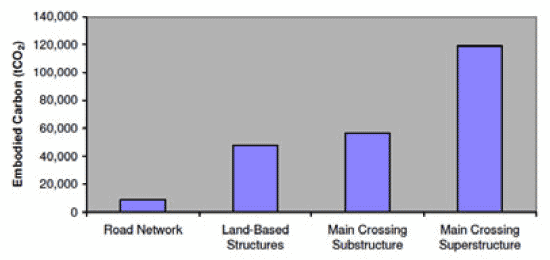
Steel is estimated to account for approximately 75% of total embodied carbon. Quarry sourced materials (soil/earth, aggregates, stone, etc) make up around 14% of total embodied carbon, while cement and concrete account for around 11%.
The energy and carbon report also contains an initial examination of carbon emissions associated with the transport of materials to site. Emissions from transport will depend on:
- the quantity of material to be transported;
- where the material is sourced from (i.e. distance to site); and
- the predominant mode of transport used.
By way of illustrative example, four possible sourcing scenarios for steel were considered. These options are presented in Table 12.
Table 12: Sourcing Options for Steel
| Option 1 |
All steel sourced a distance of 400 km (approximate distance Edinburgh to Sheffield) from site and transported by rail to site |
|---|---|
| Option 2 |
All steel sourced a distance of 400 km from site and transported by road to site |
| Option 3 |
All steel sourced from Rotterdam, the Netherlands, (approximately 730km) and transported by sea to site |
| Option 4 |
All steel sourced from China (approximately 17,000 km), being the furthest producers from site, and transported by sea to site |
The results are summarised below in Table 13. These calculations are for emissions associated with transport only. Of the three options, Option 3 would result in the lowest amount of CO2 being emitted, while Option 4 would result in the highest. Choosing option 3 over option 4 would result in a carbon saving of 10,397 tCO2.
Table 13: Carbon emissions associated with the different sourcing options for steel
| Material |
Total Mass of Steel Material (tonnes) |
Carbon Emissions associated with Transport (tCO2) |
|||
|---|---|---|---|---|---|
| Option 1 |
Option 2 |
Option 3 |
Option 4 |
||
| Steel |
90,000 |
1,148 |
3,096 |
466 |
10,863 |
Future Opportunities
A number of potential measures have been identified with the aim of reducing embodied energy and carbon associated with construction materials to be used in the scheme. Examples of such measures include:
- using recycled aggregate instead of quarried aggregate – it is estimated that the embodied carbon of recycled aggregate is 54% lower compared to quarried aggregate;
- using an increased proportion of recycled steel – the embodied energy and carbon of steel from secondary sources is significantly lower than that from primary sources. The potential for use of recycled steel is dependent on the required steel specification;
- steel could be sourced from a number of locations and transported to site using different transport options; and
- other sustainability factors also need to be considered in the scheme design and materials planning, such as durability and the life span of products, performance, ability to reuse materials after decommissioning. These issues are addressed within the Sustainable Resource Management Framework (Appendix 5). Section 5 of this report also provides a further discussion of how sustainability has influenced and informed scheme design.
The Contractor will be provided with the relevant data to calculate embodied energy and carbon in their final design. This can then be compared to the calculations presented in Appendix 6 and this should preferably improve on the baseline condition.
4.14.2 Target 2: Minimise energy use and all carbon emissions during construction.
Target Selection
This target was selected to promote the minimisation of energy use and carbon emissions during construction.
Indicators
- Predicted energy requirement and CO2 emissions.
- Actual energy used and CO2 emissions.
Appraisal Findings
Predicted energy use and CO2 emissions during construction have not been estimated for Stage 3 design, since detailed methods of construction are not known at this stage. Once the Contractor develops the detailed design and construction methodology, meaningful figures can be calculated. Actual energy use and CO2 emissions will be monitored during construction.
Future Opportunities
A number of measures are being considered for incorporation into the design of the scheme aimed at reducing energy consumption and/or carbon emissions during construction. Examples of such measures include:
- installing energy-efficient lighting systems;
- sourcing electricity from renewable/sustainable sources;
- programming of earthworks to minimise ‘double-handling’ of materials; and
- a ‘Green Travel Plan’ to be developed by the Contractor for site workers. This will promote sustainable forms of travel (car sharing, public transport etc) for employees travelling to and from site, where practicable.
The Contractor will be required to implement a site energy management plan, demonstrating measures to reduce energy consumption and/or carbon emissions during construction.
4.15 Sustainability Objective 13: To Minimise Carbon Emissions Once the Scheme is Open to Traffic
4.15.1 Target 1: Seek to reduce CO2 emissions from vehicles crossing the Forth at Queensferry compared with existing FRB
Target Selection
This target recognises the impact of CO2 emissions from vehicles crossing the Forth and seeks to identify design measures to reduce emissions.
Indicators
- Predicted CO2 emissions per veh-km.
Appraisal Findings
In terms of emissions of greenhouse gases such as CO2 associated with the operation of the scheme, the ES (Chapter 15: Air Quality) reports a predicted increase in CO2 with the proposed scheme in place, due to more vehicle kilometres being travelled. The scheme will increase the length of the majority of cross-Forth journeys by about 1km because the new crossing is slightly further west than the Forth Road Bridge.
The increase in CO2 emissions produced by the proposed scheme in 2017 is 14,952 tonnes. This figure is derived from strategic modelled traffic data covering the national road network using established Department for Transport methodology. Although small in an overall Scottish context, this increase does not contribute to the requirement in the Climate Change (Scotland) Act 2009 to reduce emissions by 42% by 2020 (interim target) and 80% by 2050. Therefore, the increase in CO2 as a result of the proposed scheme will require to be offset by greater reductions elsewhere within Scotland.
Further assessment was carried out to more fully capture the localised effect of "stop-start" motoring conditions on the congested approaches to the Forth Road Bridge and the localised benefits to be derived from relieving these conditions (refer to Appendix 6). The assessment involved modelling a local network in the vicinity of the Forth Replacement Crossing using an alternative approach that better takes into account the emissions from such "stop-start" traffic conditions. Initial findings indicate that during the congested morning peak period, increased CO2 emissions from the additional distance travelled may be mitigated by reduced congestion that the proposed scheme will deliver relative to the situation without the scheme. There is less congestion relief in the evening peak and therefore the mitigating effect referred to above is less evident during this period.
As noted in Appendix 6, the scheme includes a number of features aimed at reducing CO2 emissions. These include:
- use of Intelligent Transport Systems to improve network efficiency and decrease congestion;
- infrastructure to facilitate modal shift, particularly through the provision of a dedicated public transport corridor on the FRB and associated public transport public transport lanes and public transport links; and
- encouraging and facilitating active modes of transport (e.g. cycling) by minimising impacts on paths and cycle routes and improving these where feasible.
Future Opportunities
There are no future opportunities identified for this target at this time.
4.15.2 Target 2: Minimise the energy requirements of the scheme (once it is open to traffic) to the minimum necessary for safe operation
Target Selection
This target was selected to ensure energy is used efficiently and sustainably during operation of the scheme.
Indicators
- Predicted energy requirements.
- Actual energy requirement.
Appraisal Findings
Energy requirements have been an important factor in the design of the proposed scheme and a number of design measures aimed at reducing energy use have been discussed within the project team. These included the use of energy efficient lighting and ITS equipment.
The predicted operational energy use for the following scheme components in the Stage 3 design is:
- Main Crossing dehumidification system (deck cells, southern approach viaduct and towers): 1,067,625 kWh per year;
- lighting (for road infrastructure including provision for Main Crossing, excluding any saving through dimming): 1,000,196 kWh per year; and
- ITS (based on 65 fully equipped gantries): 1,959,922 kWh per year.
These estimates are based on worst-case assumptions, and therefore present maximum KWh likely to be required. During development and refinement of the detailed design these energy requirements may be reduced.
Actual energy use will be assessed during operation.
Future Opportunities
ITS will be implemented throughout the scheme to improve operational efficiency, reduce vehicle emissions and improve air quality and noise levels through the use of traffic control measures.
The lighting to be installed along the scheme will allow for dimming and remote control for future energy reduction to support government objectives to reduce carbon emissions, pollution of the night sky and to reduce impacts on the rural landscape where this can be achieved safely and effectively.
4.15.3 Target 3: Maximise the percentage of required energy for the scheme (once opened to traffic) acquired from renewable sources
Target Selection
This target reflects the importance of sourcing energy for the scheme in a sustainable way. Using renewable energy has a variety of sustainability benefits, especially in terms of reducing dependence on fossil fuels and lowering overall carbon emissions.
Indicators
- Predicted energy sources.
- Actual energy sources.
Appraisal Findings
The potential for incorporating renewable energy technology into the scheme or sourcing energy from renewables was discussed within the project team and it was agreed to continue to review the potential for renewables during the tender stage.
Future Opportunities
The relevance of the targets in respect of construction are uncertain but will be reviewed during the tender stage to consider any potential, associated with the operation of the scheme.
4.16 Sustainability Objective 14: To protect and enhance the natural heritage including local biodiversity
This objective is achieved through careful alignment and design based on constraints identified in baseline surveys as well as complying with the DMRB (Highways Agency 1993), and following IEEM 2006 EIA guidance. In addition the mitigation design has been agreed with Scottish Natural Heritage (SNH).
There are two targets associated with achieving this objective and performance on each is summarised below.
4.16.1 Target 1: To minimise number of sites designated for natural heritage conservation and protected species affected and significance of any adverse impacts
Target Selection
This target reflects the importance of achieving a design that minimises impacts on natural heritage.
Indicators
- Number and type of sites (e.g. international and local) and protected species impacted and significance of predicted impacts.
- Actual impacts on sites and protected species during construction.
Appraisal Findings
The proposed scheme crosses over land that is of high ecological value, including the Firth of Forth SPA, St. Margaret’s Marsh SSSI, and Ferry Hills SSSI. The scheme’s design was informed by ecological constraints identified from data collection that included consultation, desk based searches and field surveys. This enabled impacts to natural heritage including woodland, other semi-natural habitats and protected species to be minimised.
The direct and indirect effects of the scheme on sites of European importance have been considered in Reports to Inform Appropriate Assessments for the Firth of Forth SPA, Forth Islands and Imperial Dock Lock, Leith SPAs and the River Teith SAC (Jacobs Arup 2009c, 2009d, 2009e). The conclusions of the reports are that the integrity of the sites would not be affected. The conclusions of the relevant EIA chapters of the ES were also that provided the committed mitigation is robustly implemented there would be no significant effects on local nature conservation and that the scheme provided some opportunities to enhance local biodiversity in the longer term.
There are no predicted residual impacts on the following protected species during construction or operation: badgers; terrestrial wintering and breeding birds; amphibians, reptiles and terrestrial invertebrates.
Table 14 provides a brief summary of residual impacts on protected species and habitats as a result of the proposed scheme. More detailed appraisal findings are available in the ES Chapters 10 (Terrestrial and Freshwater Ecology) and Chapter 11 (Estuarine Ecology).
Table 14: Summary of Residual Impacts on Protected Species and Habitats
Terrestrial Habitats |
Significant positive residual impact at Swine Burn Significant positive residual impact at St. Margaret’s Marsh (pending further consultation and agreement). |
Bats |
During construction some significant negative residual impacts of negligible magnitude at Port Edgar Barracks and West of South Queensferry. Significant positive residual impacts of high magnitude are predicted at North and South Queensferry during operation, due to the provision of a third crossing over the Firth of Forth which would facilitate further bat movements between Fife and the Lothians. |
Otters |
During construction, there would be some significant negative residual impacts of low magnitude at the Swine Burn, Niddry Burn and River Almond. In the long- term these impacts are not considered to be significant. |
Freshwater Ecology |
Significant positive residual impacts of medium magnitude during operation for all receptors through the inclusion of meanders and bends as part of the Swine Burn realignment, in addition to the provision of riparian planting. Significant positive impact of low magnitude for freshwater fish would remain due to increased cover provided by the new culvert on the Swine Burn and extensions to existing culverts on Swine Burn and Niddry Burn. |
Estuarine Ecology |
During construction, residual impacts from noise and vibration on estuarine ecology have been assessed as extremely unlikely to occur. IN the event impacts do result they would be of low magnitude. During construction, residual impacts of temporary and permanent benthic habitat loss are certain to occur resulting in a residual impact of low magnitude. During construction, mitigation would reduce the likelihood of a chemical spill during the construction phase and an impact is extremely unlikely to occur. Should a spill occur it may result in a significant residual impact of low magnitude. During operation, the impact of a spillage from a road traffic accident on the Main Crossing on all receptors is extremely unlikely to occur. Should a spill occur it may result in a significant residual impact of low magnitude. |
Future Opportunities
A significant positive residual impact of medium magnitude could be achieved through the management of wetland habitats at St. Margaret’s Marsh SSSI during operation, pending further consultation and development/agreement of between Transport Scotland and SNH.
4.16.2 Target 2: To protect and enhance biodiversity
Target Selection
This target reflects the importance of achieving a design that conserves and enhances local biodiversity.
Indicators
- Number of watercourses impacted and significance of predicted impacts.
- Actual number of watercourses impacted and significance of impacts.
- Actual impacts on water quality.
- Number of reported roadkills of protected species.
- Percentage area of new habitats compared with areas lost.
- Number of new records of species and habitats of nature conservation value.
Appraisal Findings
A number of design features have been incorporated into the design to protect and enhance biodiversity including semi-natural habitats and protected species. Where possible, the proposed scheme has been designed to avoid important habitats for plants, birds and animals.
There are 10 waterbodies within the study area that would be potentially impacted by the proposed scheme. With mitigation, during both construction and operation, residual impacts on all of these waterbodies would however be reduced to slight or negligible significance. Impacts on water quality would be reduced to negligible for all 10 waterbodies.
The number of roadkills will be monitored during operation.
Some of the land-take for the proposed scheme will encroach upon ecological habitat. Wherever possible, replanting has been incorporated into the scheme design as mitigation to offset habitat lost to the scheme. As a result of the scheme there is predicted to be net gain of 35ha of semi-improved grassland, 19.2ha of plantation mixed woodland, 5.8ha of dense/continuous scrub and less than 1ha of swamp. Habitats which are predicted to experience a net loss are poor semi-improved grassland (4.9ha), plantation broadleaved woodland (3.2ha), semi-natural broadleaved woodland (1.2ha) and scattered scrub (1.1ha).
In addition to planting to reduce and offset potential adverse impacts on ecology, the following mitigation measures are described in the ES:
- translocation of important species;
- provision of replacement badger setts; otter holts and bat boxes;
- use of mammal underpasses and fencing to guide animals to the tunnels;
- integration of mammal ledges in new culverts;
- ensuring that culverts and watercourse realignments are constructed in accordance with best practice guidelines;
- employing an Ecological Clerk of Works to supervise the works;
- sensitive timing of construction activities; and
- the use of acoustic deterrents during key construction periods to deter sensitive marine species from entering the area.
Future Opportunities
A significant positive residual impact of medium magnitude could be achieved through the management of wetland habitats at St. Margaret’s Marsh SSSI during operation, pending further consultation and development/agreement between Transport Scotland and SNH.
4.17 Sustainability Objective 15: To protect the landscape, historic environment and cultural heritage
4.17.1 Target 1: develop alignment and design to avoid or minimise impacts on the landscape resource and character, and setting of cultural heritage features
Target Selection
This target was selected in order to promote the minimisation of impacts on landscape and cultural heritage in the scheme design.
Indicators
- Reported significance of residual landscape effects
- Number of and significance of direct and indirect residual effects on cultural heritage sites
- Actual number of and significance of direct and indirect residual effects on archaeological sites and monuments
Appraisal Findings
This objective is achieved through careful alignment design as well as complying with the DMRB and following the relevant landscape and historic environment legislation.
A summary of the appraisal findings of ES Chapter 12 (Landscape) indicate the following:
- north of the Firth of Forth: the Main Crossing and northern route would have significant adverse impacts for the landscape of Ferry Hills and the area of reclaimed coastal flat, which features St. Margaret’s Marsh, west of North Queensferry; and
- south of the Firth of Forth: the landscapes of South Queensferry and the farmland of Duddingston, to the west of South Queensferry, would be adversely affected by the Main Crossing and southern connecting roads. Main Crossing impacts are considered adverse in this location owing to the presence of the bridge abutment and approach road structures. The designed wooded landscape of Dundas would also be adversely affected by significant impacts from the proposed scheme. Elsewhere, impacts upon the surrounding landscape would not be significant.
In terms of cultural heritage, there are two sites which are predicted to experience residual direct impacts of moderate significance: Beamer Rock Beacon and Dundas Castle Designed Landscape. Significant residual impacts on setting are predicted for five sites: substantial at St. Margaret's Hope, St. Margaret's Hope Relict Country Estate and Port Edgar Harbour Barrack Complex; and moderate at Ferry Craig, South Queensferry, Inchgarvie House and Inchgarvie House Lodge. All other residual impacts would be of slight or neutral significance, with slight positive impact on the setting of the Forth Road Bridge.
In order to reduce impacts on cultural heritage features and landscape resource and character the following mitigation measures will be put in place:
- building recording prior to construction;
- vibration monitoring of buildings during construction;
- integration of the alignment and earthworks with the surrounding landform;
- formation of new rock cuttings to achieve a natural appearance;
- provision of false cuttings;
- replacement stone walls and noise barriers; and
- planting mixed or scrub woodland, hedges and standard trees to reflect existing boundaries and/or provide screening.
Future Opportunities
It is considered that through careful alignment design development and the mitigation measures described above this target has been met. No future opportunities are identified at this stage.
4.18 Sustainability Objective 16: To reduce noise and air emissions
4.18.1 Target 1: Manage effectively construction noise impacts and reduce and mitigate significant operational noise impacts where practicable
Target Selection
This target was selected in order to promote the reduction and mitigation of impacts associated with construction and operational noise where practicable.
Indicators
- Noise level changes and associated changes in nuisance levels at quantified numbers of dwellings/groups of dwellings within 600m in accordance with DMRB methodology.
- Number of legitimate complaints about noise nuisance.
Appraisal Findings
Construction noise has been assessed as part of the environmental assessment process, with some temporary adverse impacts potentially occurring within the vicinity of the construction compounds. Mitigation has been suggested (where appropriate) to reduce the level of impact from construction activity and a Code of Construction Practice (Jacobs Arup 2009f) has been developed to assist the Contractor in ensuring that disruption during construction is kept to a minimum.
Where operational impacts are likely to result in significant adverse effects, noise barriers have been proposed and noise insulation requirements have been highlighted at qualifying properties in the ES. At some properties, particularly close to the Forth Road Bridge, the proposed scheme will have beneficial changes in noise level.
A noise nuisance analysis was undertaken as part of the noise assessment in Chapter 16 (Noise and Vibration) of the ES. In summary, noise level increases of less than 3dB(A) would affect 2180 fewer dwellings than without the proposed scheme and 990 more dwellings would be subject to increases of greater than 3dB (A). Noise level decreases of less than 3dB(A) would affect 560 more dwellings than without the proposed scheme and 630 more dwellings would be subject to decreases of greater than 3dB (A).
Complaints concerning noise nuisance will be monitored throughout construction and operation.
Future Opportunities
The Code of Construction Practice (Jacobs Arup 2009f) and Employer’s Requirements will assist in ensuring that noise and air emission impacts are properly managed.
4.18.2 Target 2: Air quality limit values (absolute concentrations) not to be exceeded (40µg/m3 for NO2; 18µg/m3 for PM10) at selected residential properties and other sensitive receptors
Target Selection
This target aims to minimise the opportunities for air quality limits to be exceeded as a result of the proposed scheme at residential properties and other sensitive receptors for both 2017 and 2032.
Indicators
- Absolute concentrations (µg/m3) for NO2 and PM10 at selected residential properties and other sensitive receptors.
Appraisal Findings
Sensitive receptors are all located within the local air quality study area, together with representative residential properties within 200m of road links affected by the proposed scheme outside the local study area.
At all residential properties and sensitive receptors, the concentrations of NO2 and PM10,as a result of the proposed scheme, are not predicted to exceed 40µg/m3 and 18µg/m3 respectively. The highest values predicted for the receptors assessed within the study area in 2032 (do-something) are 29µg/m3 for NO2 and 14.4µg/m3 for PM10.
The predicted impacts on local air quality as a result of the proposed scheme are generally very small, therefore no mitigation measures are proposed with respect to operational traffic. During construction the Contractor will implement a Dust and Air Quality Management Plan to limit the air pollution from transportation and storage of materials and from construction plant and vehicles.
More detailed appraisal findings are available in the ES Chapter 15 (Air Quality).
Future Opportunities
A dust and air quality monitoring programme for construction activities will be agreed with the local authorities and it will be the Contractor’s responsibility to monitor air quality throughout the construction period.
4.18.3 Target 3: Dust deposition to be contained within rate limit values
Target Selection
This target was selected to ensure that dust deposition rates do not exceed limit values at sensitive receptors as a result of the construction of the scheme.
Indicators
- Dust deposition rates during construction that exceed 200mg/m2/day.
- Dust deposition rates for biological SSSIs that exceed 1000mg/m2/day.
Appraisal Findings
Dust nuisance is the result of the perception of the soiling of surfaces by excessive rates of dust deposition and is defined as a statutory nuisance by the Environmental Protection Act (1990). Potential nuisance arising from dust is likely to occur at sensitive receptors where deposition rates exceed 200mg/m2/day and for sensitive plant species at rates of greater than 1000mg/m2/day (Highways Agency 2007).
As reported in the ES, without mitigation the risk of dust nuisance occurring on receptors up to 200m from the construction of the proposed scheme would be high. This would be due to the location of sensitive receptors in close proximity to the site boundary, and the duration of the works, rather than the level of dust generated from the works. The amount of dust generated from the construction of the proposed scheme is not predicted to exceed 200mg/m2/day at the construction sites or sensitive receptors.
The Contractor has an obligation under the Environmental Protection Act 1990 to use best practicable means to prevent or counteract the effects of any dust nuisance. The Contractor will prepare and implement a Dust and Air Pollution Management Plan to set out the controls to be implemented to limit dust and air pollution due to the works. Dust mitigation measures as set out in the Code of Construction Practice, ES and Employers Requirements will aid the minimisation of dust nuisance at sensitive receptors. This will generally reduce this risk to medium to low and would occur on a short to medium term basis only for all properties other than Inchgarvie House where, due to the close proximity to the construction works for the Main Crossing, it is anticipated that the risk of dust nuisance may be higher during certain activities.
Future Opportunities
Site layout of construction compounds (not yet established) can further help to reduce dust arisings at residential receptors.
Dust monitoring results would indicate whether dust mitigation measures are effective and deposition is below the specified rates or whether additional measures are required.
4.19 Sustainability Objective 17: To protect water quality, geomorphology and maximise the use of sustainable drainage systems for environmental and hydrological benefit
4.19.1 Target 1: Limit impacts and significance of residual effects on water quality and pass majority of runoff through SUDS
Target Selection
This target was selected to ensure water quality is not significantly affected as a result of the proposed scheme. This will be achieved by passing the road surface runoff through a series of Sustainable Drainage Systems (SUDS).
Indicators
- Percentage of mainline drainage passing through SUDS.
Appraisal Findings
The different SUDS systems filter out contaminants from the runoff before the runoff enters the nearest watercourse. SEPA generally requires 2-3 levels of SUDs be achieved for new sections of road.
In addition, any increase in pavement area requires the runoff to be controlled so that no additional flooding occurs. This requires detention basins to be designed and constructed which hold the road runoff and then empty over approximately 24hours to control the rate of flow going in the watercourse. Agreement on flooding control is required with the Local Authorities
After consultation with SEPA and subsequent alignment changes to help with the road drainage the vast majority of surface runoff for the trunk roads including motorways passes through SUDs. The only exception to this is the Main Crossing over the Forth. The sections of the crossing that are over land and the intertidal zones will drain back to a SUDs basin on either side of the crossing. The centre section of the crossing will drain directly into the Forth.
The design will result in approximately 80-85% of the drainage from the Trunk Roads including motorways passing through SUDs.
The residual impact significance for all assessed watercourses would be reduced to negligible in terms of water quality.
Future Opportunities
The maintenance contractor will be expected to ensure the efficient operation of the SUDS network.
4.19.2 Target 2: Limit watercourse re-alignments and limit number of watercourse crossings
Target Selection
This target was selected to avoid and reduce impacts on watercourses as a result of the scheme infrastructure where practicable.
Indicators
- Attainment of Controlled Activities Regulation (CAR) Licence.
Appraisal Findings
The new scheme makes use of existing infrastructure where possible, with the result that watercourse crossings and re-alignments have been kept to a minimum.
The southern section of the new scheme is the only part that has any direct effect on watercourse alignments. Initially the alignment of the new northbound slip from the M9 to the M9 Spur required a number of new culverts on the Swine Burn. After discussions between the FRC team, SNH and SEPA the alignment of the slip was altered and a realignment of Swine Burn was proposed to reduce the number of crossings of the Swine Burn. The realignment has resulted in only one new crossing of the Swine Burn and the new culvert has been reduced to approximately 65 metres in length. The realignment has the added benefit of providing a more natural channel for Swine Burn as the current channel (designed to previous standards) is straight and has the appearance of being heavily engineered.
The indicator for target 2 is the attainment of the CAR licence. The licence will require a report to be submitted outlining in detailing the five watercourse crossings, realignments and culvert extensions that are being proposed. In addition plans showing the drainage outfall details will be prepared.
Consultations have been held with SEPA regarding the CAR licence and it is the intention to pursue a CAR licence from the agreement in principle.
Future Opportunities
The base case will be the Stage 3 design. The participating contractor will be expected to meet or improve on this during detailed design.